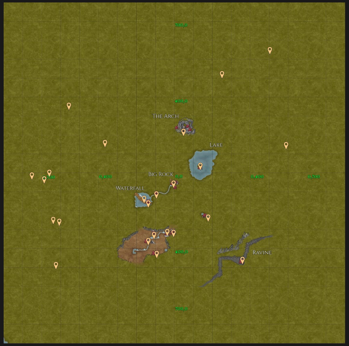
Below is a compendium of the locations of all Elder Crystals! I managed to find 16, but the rest were found/shown to me by other members of the community! All the help given in finding the locations to compile into this list is greatly appreciated!
Key: New coordinates added will have a star next to them (to be added)
Raw Elder Crystal Coordinates
South x West Coordinates
- 14.2 S x 550.0 W
- 17.9 S x 596.2 W
- 318.5 S x 14.6 W
- 61.0 S x. 7 W
- 324.0 S x 40.7 W
- 367.3 S x 141.0 W
- 493.3 S x 623.9 W
- 2 S x 664.7 W
- 269.2 S x 612.0 W
- 161.0 S x 144.4 W
- 12.7 S x 751.8 W
- 327 S x 110 W
- 133 S x 164 W
- 255.6 S x 638.2 W
- 419.1 S x 97.6 W
- 395 S x 37 W ⭐
- 466 S x 141 W ⭐
- 732 S x 731 W ⭐
- 111 S x 97 W
- 147 S x 616.2 W ⭐
South x East Coordinates
- 50.8 S x 13.4 E
- 47.1 S x 14.1 E
- 72.3 S x 7.6 E
- 50.1 S x 7.6 E
- 231.2 S x 161.1 E
- 480.5 S x 349.6 E
North x East Coordinates
27.26.8 N x 136.2 E
28. 233.6 N x 14.5 E
29. 245.6 N x 70.7 E
30. 253.5 N x 85.1 E
31. 147.8 N x 474.6 E
32. 517.9 N x 247.2 E
33. 654.4 N x 496.9 E
North x West Coordinates
- 162.5 N x 375.5 W
- 362.1 N x 563.0 W
Below is a location based list of the coordinates, contributed by @west axle (thank you) with some heavy editing done by me as coordinates have been added by others!
Location Based List of Coordinates
Snowy Mountain Peaks
- 517.9 N x 247.2 E
- 654.4 N x 496.9 E
Snow Ridge
- 162.5 N x 375.5 W
Arch
- 233.6 N x 14.5 E
- 245.6 N x 70.7 E
- 253.5 N x 85.1 E
Big Rocks
- 47.1 S x 14.1 E
- 50.1 S x 7.6 E
- 50.8 S x 13.4 E
- 61.0 S x 0.7 W
- 72.3 S x 7.6 E
Island
- 26.8 N x 136.2 E (On the tall rock's ledge)
Pride Rock
- 231s 161e
World Tree/Jrahkon Falls
- 111s 97w
- 133 S x 164 W
- 161 S x 144 W (on a ledge 3/4 the way up a waterfall)
Sanctuary
- 319.0 S x 14.9 W (On the rock ledge overlooking the south end of the pond)
River
- 317.5 S x 14.8 W
- 324.0 S x 40.7 W
- 327 S x 110 W
- 367.3 S x 141.0 W
- 420 S x 97 W (On a ledge on the south wall, 23. kind of out of the way)
- 395 S x 37 W ⭐
- 466 S x 141 W ⭐
Lime/Misty Lake
- 362.1 N x 563.0 W (Next to a small rock shelf a small distance from "Lime"'s shore, between it and Misty Lake)
Flight Rock
- 147.8 N x 474.6 (On the rock spire)
Elder Forest
- 0 S x 664 W
- 12.7 S x 751.8 W
30.17.9 S x 596.2 W (Rock Ridge border between Elder Forest and "Lime") ⭐ - 255.6 S x 638.2 W
- 269.2 S x 612.0 W
- 493.3 S x 623.9 W (Big Tree Pond, under the roots of the Big Tree and partially in the water)
- 732 S x 731 W ⭐
- 147 S x 616.2 W ⭐
Ravine
- 480.5 S x 349.6 E (On the largest land platform)


 ty
ty


 could we put a star next to the newly added cords as i'm blind and dumb lol


 honestly doesnt seem right but whatever.
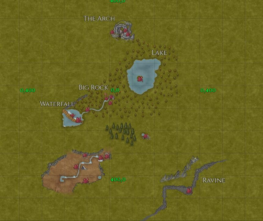


 nice thing is too is ASD can launch itself off that rock and right into trees to escape fliers


 The Weasel map isn't the best, but even with a better map you can't solve the main problem here: DoD has a huge generic, natural looking locations/areas, but there's a lack of really usable/game relevant points of interest. It might be good if you want to explore the landscapes of Northern Europe or Canada in Microsoft Flight Simulator, but for a dragon fantasy game it's unlucky world design.


