#enfusion_terrain
56 messages · Page 1 of 1 (latest)
 clever timber
and it was a custom heightmap I did manually from scratch not one imported.
idk whatcha mean? I have the terrain folder and the data. just for some reason it refuses to load it
they changed the directory order in 1.7 for how maps are configured so the way I had it prior everything is sideways now
but 1.6 update and prior never had this issue with how all the files were set.
Terrain folder (these are the original files that were working before 1.7)


so all the files are still existing like you said. but enfusion is not locating or reading any of it.
And if i shift the folders into different subfolders etc it tends to just crash tools at launch
If I shift my .ent world into the Worlds subfolder and leave Terrain subfolder in main directory and layers in main directory I get this

which either option does nothing.
 silk basin
clever timber
idk whatcha mean? I have the terrain folder and the data. just for some reason i...
silk basin
clever timber
idk whatcha mean? I have the terrain folder and the data. just for some reason i...
In case you don’t know Lou is a moderator plus part of the Bohemia team. It sounds like you have a huge issue/bug. seems like he’s offering to look into it for you.
clever timber
I have to have my DoungIsland_Layers subfolder in the Worlds folder I created (there was no Worlds folder prior in my map directory I had to manually create one today)
So now that I just put the DoungIsland_Layers subfolder in and the .ent file is ALSO in the Worlds folder, this is what everything looks like

Notice I have a terrain entity.
and I have the Terrain folder with all the files
therefor I HAD a working terrain
clever timber
silk basin
In case you don’t know Lou is a moderator plus part of the Bohemia team. It soun...
i did not know
yee i was talking with him this morning
silk basin
clever timber
i did not know
All good. Sounds like he may be offering to have you send your project over somehow for them to look at. I could be wrong. I’d offer to try and help on a screen share I just don’t know when I’ll have time.
clever timber
i have all the data for the terrain but if I move the terrain folder into the world subfolder. it crashes with a Invalid authorization exception saying it cant find a string
OOOO
That being said yeah im willing to send files over.
@civic lava im EST Based by the way. I will DM you and if you'd like I can send over the folder in a zip
i can even open all the terrain files in resource browser as well
 tawny roost
silk basin
All good. Sounds like he may be offering to have you send your project over some...
tawny roost
silk basin
All good. Sounds like he may be offering to have you send your project over some...
Hey man your YouTube Vids are a life saver
silk basin
tawny roost
Hey man your YouTube Vids are a life saver
Thank you always appreciate hearing they help! The large majority of the info comes from all the helpful people on this channel and the Atlas guide.
 stable pecan
Hey guys, I need your help with setting the grass (surface) draw distance in the editor.
The problem came up when I wanted to make an airport, and the runway just wouldn't render. Can someone help me with this?

Can you tell me how you did it?
 cyan knot
stable pecan
Hey guys, I need your help with setting the grass (surface) draw distance in the...
cyan knot
stable pecan
Hey guys, I need your help with setting the grass (surface) draw distance in the...
gonna go out on a limb cause its late asf; Repaint surface area with asphalt or whatever. Export textures and rebuild sat map import then lay airport and clean up?
 cerulean hare
stable pecan
Can you tell me how you did it?
cerulean hare
stable pecan
Can you tell me how you did it?
certainly give me a second
only for the mist right?
inside resource browser "Arma reforger" -> "Prefabs" -> "Particles" -> "Water" here you will find a couple of effects for a swamp i prefer the quick and easy "water_steam_02" while technically steam it does work for a little bit of scenic fog
 manic pollen
Does anyone here know of any good vanilla assets for creating tunnels using the new "Holes Tool"?
cerulean hare
yup, just a sec
cerulean hare
manic pollen
Does anyone here know of any good vanilla assets for creating tunnels using the ...
just done on that looks like this
 manic pollen
Do you also know a few involving earth?
cerulean hare
this is what it comes down to. use those mine assets for the base and upcale it, same with the concrete pipe
 cerulean hare
manic pollen
Do you also know a few involving earth?
cerulean hare
manic pollen
Do you also know a few involving earth?
as in a dirt tunnel
manic pollen
cerulean hare
this is what it comes down to. use those mine assets for the base and upcale it,...
Already tried this Prefabs but im not happy with it 😄
cerulean hare
pretend i'm an ai for a sec what do you like the tunnel to look like, materials, size, general look
manic pollen
something like that but i dont think it´s possible with Vanilla Prefabs
 manic pollen
cerulean hare
i got some ideas
manic pollen
cerulean hare
i got some ideas
Thanks mate
 floral wharf
Can you flip trenches upside down? Never used them , just wondering if they would work for your tunnel
manic pollen
floral wharf
Can you flip trenches upside down? Never used them , just wondering if they woul...
Well that Sounds interesting. I´ll try haha
manic pollen
floral wharf
Can you flip trenches upside down? Never used them , just wondering if they woul...
Yea it look pretty good. Thanks! The Topside looks a bit weird, but that's okay.
 floral wharf
I'll have to give it a go sometime.
You could also have rocks on top of you wanted a different surface on ceiling or walls.
I have used rocks inside underground bunkers for a varied surface. Looks okay sometimes.
manic pollen
I'm going to try out a few different things to see what looks best. Rocks are so basic... 😄
cerulean hare
i got this thing down but i need to find something to replace the floor with


 bleak geyser
Hey guys, is there a way to get this leaves generator to go on top of a road?

experimenting and figured this would be good for putting leaves along the kerbs
 twilit prawn
Hey currently establishing a community. It's gonna be a Life/RP community. My skills are sorely, coding, so i will build the server. What i need is someone that is good with map knowledge and terrains.
Message me if interested!
bleak geyser
twilit prawn
Hey currently establishing a community. It's gonna be a Life/RP community. My sk...
I would post this is in #creators_recruiting instead my guy, more likely to be seen and get a response. Will just get lost in here.
twilit prawn
bleak geyser
I would post this is in <#292271129303842817> instead my guy, more likely to be ...
Apreciate it mate, can be hard to navigate this discord 😄
 solemn dune
so anyone figured out how to start making terrains ? 🙂
solemn dune
coolio 😄
 buoyant lark
oh i should post in #world_editor
 lament crown
oh, now THIS is the most important channel
 fringe pasture
oh hey this channel exists
 neat trellis
Hope this helps people get a few steps further into making terrains in Enfusion.
- File\New world
- Save world (needed to make a terrain object later)
- Bottom-left, select the 'Create' tab, next to Hierarchy.
- Search 'GenericTerrainEntity'
- Drag it into the game perspective window
4.1 - Switch back to Hierarchy tab from the Create tab.
4.2 With object selected in hierarchy, Bottom-right - in the Object Properties: Set X, Y, Z co-ords to 0 for each - Right side of screen - Object Properties: Right-click 'GenericTerrainEntity', under the search 'Filter components' - Select 'Create new terrain'
For a quick test, set Terrain grid size to 1024 - keep everything default. Select 'Create'
You now have access to the Terrain tools! Either:
A. Press the mountain button on the buttons toolbar
B. Tools\Terrain Tool
Terrain tool will appear in the bottom-right. You can now import height map, sat map etc.
Supported file types are .png and .asc for heightmaps
Credits to a twitch streamer called 'theemperorfox' who I was watching do this
 true hearth
neat trellis
Hope this helps people get a few steps further into making terrains in Enfusion....
true hearth
neat trellis
Hope this helps people get a few steps further into making terrains in Enfusion....
Can this be pinned till the Wikis are live?
neat trellis
With that I was able to get my heightmap/sat map in - https://i.imgur.com/Nayko9W.png
 stray briar
errain grid size to 1024 ! where do you find it? I do not below GenericTerrainEntuti
fringe pasture
lol it just crashes for me every time I try and save
 mental pecan
fringe pasture
lol it just crashes for me every time I try and save
mental pecan
fringe pasture
lol it just crashes for me every time I try and save
Don't save the world to a locked folder in Armareforger
 burnt torrent
Are you guys launching this via Arma Reforger Tools in Steam and then pressing Launch?
fringe pasture
yes
burnt torrent
oh weird. I had been trying to press Create New before opening Reforger for the first time and it wasn't letting me go anywhere but now that actually worked
 left tangle
neat trellis
Hope this helps people get a few steps further into making terrains in Enfusion....
left tangle
neat trellis
Hope this helps people get a few steps further into making terrains in Enfusion....
4.1 zero all coordinates of terrain entity to 0, last time i had the entity moved collision of the terrain itself didn't work
burnt torrent
neat trellis
With that I was able to get my heightmap/sat map in - https://i.imgur.com/Nayko9...
Kiska?
neat trellis
burnt torrent
Kiska?
Sorta, it's Skira from Operation Flashpoint: Dragon Rising, which is a sort of recreation of Kiska. I initially tried to make Kiska but ultimately ran into the same problems the people making the map did - it isn't fun to play on, nor has any real points of interest, so I instead decided to recreate Skira.
burnt torrent
Oh okay. That explains the few differences that I saw then. I had almost made an island based on that back in the A2 days but more of a temperate Chernarus type place.... actually at this point I've probably have had plans to make a terrain based on every island in the world at some point 😄
 zinc ruin
@burnt torrent HI mate 😉
burnt torrent
zinc ruin
<@162688169580429312> HI mate 😉
Hey Miro! Those your blender tools in the reforger tools?
burnt torrent
buoyant lark
there's too many channels on all this stuff now
Yeah I'm not sure which I'm supposed to be posting in now. I figured terrain makers is probably more of a arma 3 thing at this point though maybe?
buoyant lark
whats an arma 3?
fringe pasture
fair
zinc ruin
burnt torrent
Hey Miro! Those your blender tools in the reforger tools?
some bLT stuff slipped to Enfusion Blender Tools yeah ... namely ASC import/export ... the rest is more game assets creation focused
burnt torrent
zinc ruin
some bLT stuff slipped to Enfusion Blender Tools yeah ... namely ASC import/expo...
Nice! I'll have to try those out. Congrats to you and your coworkers on the release! It's looking great so far!
zinc ruin
Thanks mate, glad to hear!
 humble apex
 grave basin
Anyone else's world editor crashing when saving?
fringe pasture
save to your own folders
grave basin
oh
 raven lance
Can't save read only stuff. 😛
grave basin
yeah I'm coming from UE4/UE5 so I'm too used to that haha
buoyant lark
cant paste/copy paths into the file selector stuff in workbench ;_;
and it doesn't use the native file selector and instead uses the one from qt
 lone sinew
neat trellis
With that I was able to get my heightmap/sat map in - https://i.imgur.com/Nayko9...
lone sinew
neat trellis
With that I was able to get my heightmap/sat map in - https://i.imgur.com/Nayko9...
That's the Codemaster's game island isn't it
grave basin
Dragon Rising?
buoyant lark
strange question for the BI boys.... do you guys happen to have some (basic) mapping of A3 objects to some Enforger thing? I'd like to see if I can just write basic converted of old object list to new ones.... 😄
Well... it imports 😄
 buoyant lark
its the saaremaa that is NOT AT ALL saaremaa 😄
but i liked doing that port from BF2 PR because it took like 2 days i think.....
 sinful brook
It been a long time since I played pr
buoyant lark
https://steamcommunity.com/sharedfiles/filedetails/?id=902483985 it confused people so much
 sinful brook
Try operation marlin
buoyant lark
because its not at ALL like the real terrain.... but its the BF2 pr
buoyant lark
from the BF2 pr ones? No
buoyant lark
@left tangle if you're feeling bored... how do the surface masks work? Is it a black/white mask per mat or global color banded surface mask like RV?
Can the old ones be imported somehow?
 whole onyx
Importing Heightmap the heightmap does nothing for me.
fringe pasture
black and white mask
whole onyx
Yes indeed
fringe pasture
drop on a material on the right
right click on the material and import the black and white mask
whole onyx
Will try, thanks man
buoyant lark
whole onyx
Importing Heightmap the heightmap does nothing for me.
asc definitely works here. I was not telling it to resize heights and am telling it to flip Z
fringe pasture
can i not paste screen shots here?
whole onyx
Had to start my tools up again but I think I might be a bit blind 😅 can't see the option for material
buoyant lark
 fringe pasture
 whole onyx
Thanks
fringe pasture
buoyant lark
<@201264565680340992> if you're feeling bored... how do the surface masks work? ...
it would be pretty easy to convert the color masks to individual b/w masks
buoyant lark
fringe pasture
it would be pretty easy to convert the color masks to individual b/w masks
ye i just wanna include it gtt by default
fringe pasture
oh yeah
buoyant lark
i cant remember if already do it for UE4 export... i basically never finished that 😄
fringe pasture
you make that
left tangle
buoyant lark
<@201264565680340992> if you're feeling bored... how do the surface masks work? ...
yep, grayscale masks, one for each surface
surfaces are in .emat file (TerrainMaterial material type) and are organized in Paint tab within Terrain Tool, to which you drag'n'drop them from Resource Browser
buoyant lark
merci, i guess i gotta check the specs, bit confused with the pixel formats and so
IE mask export being 4033 for a 4096m terrain with 2 cellsize
well i wont be bored this weekend 😄
 sweet sedge
it is because similar to overlapp in a3
buoyant lark
ye but in a3 your importable files didn't have that, so I'm wondering if I can make sure to include it
sweet sedge
but here it is more inteligent in how it goes together
buoyant lark
for ref, i "just" want to make GTT be able to give pretty okay starting files for Enfusion 🙂
sweet sedge
ground textures?
buoyant lark
heightmap already a-okay, just gotta make it export to PNG for satmap
zinc ruin
buoyant lark
strange question for the BI boys.... do you guys happen to have some (basic) map...
be more precise... you want to just place objects on terrain right?
buoyant lark
sweet sedge
ground textures?
attribute mask based on either OSM data or https://www.orfeo-toolbox.org ground classification
sweet sedge
ahh
yeah
so each surface each gets a grescale and the blendinig is a bit more complicated.
buoyant lark
zinc ruin
be more precise... you want to just place objects on terrain right?
Yeah. Pretty much take a list of existing terrain builder style .txt and place "similar" entities (at least vegetation and so) VERY ROUGHLY on similar spots on enfusiont errain
 fiery bluff
sweet sedge
fiery bluff
sweet sedge
adanteh thehre are generators for that in the software thaht are pre made
zinc ruin
buoyant lark
IE mask export being 4033 for a 4096m terrain with 2 cellsize
IT'S BEEN GAMIFIED MUHAHAHA
sweet sedge
just give us some time to put out all stuff thtte next few days
buoyant lark
sweet sedge
adanteh thehre are generators for that in the software thaht are pre made
ah coolio
sweet sedge
i will have an example terrain anyone can do whatever with that works
and give it out as components you gotta put together
sweet sedge
it is fun to work in soon as you get the basics
now, what you would easily figure out adanteh, is if you open the layer files
in herarchy you make layers
in there you can place objects
then edit that and see how the matrix is and you can convert object placement from a3
buoyant lark
you mean the .layer file itself?
zinc ruin
buoyant lark
Yeah. Pretty much take a list of existing terrain builder style .txt and place "...
definitely possible you just have to use correct prefab names(.et) ... I got Tanoa into Enfusion this way, using python
fringe pasture
is there just brush tools or can we mass place forest via mask?
buoyant lark
zinc ruin
definitely possible you just have to use correct prefab names(.et) ... I got Tan...
that was my plan... 😄
sweet sedge
so you should be able to do that if you want
lancer
do this
on menu on top is a squiggly
lets you open vector tool
there you can make polylines
fringe pasture
can I use images?
sweet sedge
make a 100x100m or so one and let me know when you have
no i am showing you how the basic is realy kwik
to apply a generator
in the vector tool you can make polylines or vectors
a polyline is same as in a3
roads and rivers use vectors
zinc ruin
fringe pasture
can I use images?
nope ... but in QGIS you should be able to convert raster to vector
sweet sedge
forest generators use polylines
 tawny pike
When Nogova ? Just joking.
sweet sedge
in prefab library under generators you find stuff to add
you simply drag them onto your newly created polyline or spline in hierarchy
save first
 rancid isle
is there lakes above sea level in enfusion?
rancid isle
awesome lol
buoyant lark
... Can I have underwater terrain?
zinc ruin
sure
rancid isle
id play around in-game a bit more, but it looks like the old 1650 super isnt cutting it anymore
 wintry cypress
rancid isle
id play around in-game a bit more, but it looks like the old 1650 super isnt cut...
wintry cypress
rancid isle
id play around in-game a bit more, but it looks like the old 1650 super isnt cut...
fr
 paper ermine
how do you add the imported asc to the viewport?
wintry cypress
the game has gone from being mostly cpu dependent to gpu, which is a good thing, I just need to upgrade gpu now lol.
rancid isle
yep.. 3060 is in my shopping cart as we speak..
paper ermine
zinc ruin
https://discord.com/channels/105462288051380224/976159873517629500/9762298164351...
thanks
wintry cypress
anyone else's world editor crashing upon launch? any fix.
sweet sedge
launch it from folder, not steam mght help
wintry cypress
ok
rancid isle
sweet sedge
roads and rivers use vectors
im assuming this will be explained in documentation.. with time?
im also curious if lighting classes are set up in a similar fashion to a3
fringe pasture
well this is easy https://cdn.discordapp.com/attachments/435852895070715924/976260072135077929/unknown.png
 rancid isle
i've been looking at the weather systems but i haven't been able to get anything to work yet lol
sweet sedge
yes lancer
buoyant lark
sweet sedge
adanteh thehre are generators for that in the software thaht are pre made
Last question for this night. You mean workbench will have convertes from RV attribute mask to the mat masks or am I misunderstanding?
sweet sedge
no
i was talking about object placement conversion
if you have source files for your a3 map, you are ok. conderping a TB project. forget it
what you do is split your 5 colours situations into 5 greyscale masks
and import each
after adding the surfaces you want in the stack in world edtor
you just drag them from resource browser
buoyant lark
Names get matched right?
sweet sedge
no you import each
buoyant lark
Like it imports based on which names your mats got
sweet sedge
and if you are smort, you import, save, then do the next
dont ask tools problems here pls
fringe pasture
So for importing forests im looking to import the mask with the Shapefile import button?
sweet sedge
no
personally
when i do a shape
this is what i do
i will already have imported 3 surfaces in the area
so say i add a forest shape
with decidous trees
i quickly paint under the trees with a huge brush
you can make your own brushes
rancid isle
yeah i was wondering, how does brush creation work?
sweet sedge
i mean just spreading the surface nocely with a brush with a low setting sort of like spraypaint
you can make 500x500m shapes in like half a minute each
sinful brook
How will the object library be when people start uploading object mods to workshop will they appear in your library that you can place them on the map or will you have to import them your self somehow (talking about buildings, rocks, trees etc)
sweet sedge
i am not entirely sure as i have yet to use the public builds
sinful brook
For exmpl people upload buildings from a3 and you whant to make map with them
sweet sedge
i dont even have the game in my own steam yet :3
sweet sedge
you will be able to use things on your maps
fringe pasture
Can I import vector shapes for use as forest/road/river/lake masks
sinful brook
What you think what's the biggest terrain possible to make but to have good fps on it
sweet sedge
you will be able to make your mod depend on stuff similar to what you are used to but this is off topic to here kinda
not sure i can make a recommendatioin thehre
the question you should be asking is how big can you possible make a map and iit be good
sweet sedge
nont really
sweet sedge
you just have to find the balance of what is realistic
sweet sedge
i have had 60km maps in testing
i could finish them
i might have some screenshots actuualy i can show from years ago
sinful brook
Pleasw
Well i was thinking on making real world terrain
Is it possible to have a satelite image overlay
sweet sedge
it is absurdly easy if you use instant terra and enfusion
that is my combo with photoshop inbetween
that was my workflow for some of everon areas
whole onyx
Probably already asked what file type for satellite?
sweet sedge
png or tif or something
sinful brook
There is a good plugin online for high resolution satelite image for free
It's called fireshot
If anyone needs it
whole onyx
Have used QGIS but edited it so it's a BMP xd
sinful brook
This plugin just download it like a picture I think it's png format
 sinful brook
I saw this idk where
whole onyx
Wow
sweet sedge
i never posted that anywhere
sweet sedge
oh theres an arma 3 veresion
whole onyx
Vidda right?
sweet sedge
but the point is porting doesnt really work
yes
but recreating is much better
and relatively fast if you can manipulate thte source files
fringe pasture
Can I adjust the brightness of the satmap somewhere?
sweet sedge
when importing
please take a screenshot of the import diaog cause i donæt remember it top of my head
i doont have tools here
there is a setting to use the right colour mode
fringe pasture
 fringe pasture
for an 8k map?
sweet sedge
it is not the size of the whole map
well just try
but that linear thing should fix the sat
sweet sedge
ah
but it doesnæt need to be very high and you still get similar looking distance anyway
fringe pasture
any blending options between satmap and detail textures?
sweet sedge
yes
youll figure it out
its simple
just make sure when you edit materials in WB and looking in WE at the same time, to save the materials.
it isn't automagic. you still kinda have to work on it. you cant simply throw some colours in there and hope they don't look too bad
fringe pasture
wait, is it color matching or real blending between the textures?
OK so theres Detail, Middle, and Sat afaik
 vagrant radish
Does the engine support rivers above ASL and underground structures/carving?
fringe pasture
can i blend sat into detail and middle?
fringe pasture
sweet
sweet sedge
just play with things
remember to always have all the panels visible
cause clcking on different things in WE will make them do different things
fringe pasture
Ok, The only thing I hate
not being able to paste directories when looking for a file to import
buoyant lark
Yeah the non native qt file browser is a pain too
fringe pasture
I'm kinda confused as to why roads are like 2 meters above the spline level
sweet sedge
because not enough verts
they dont follow the terrain
they follow road curve
and they can modify the terrain annd do smoothing themselves
 brittle girder
does anyone know how this engine wants the mask image set up? I try to import it and it says "No surface masks to import were found in the import directory"? I have it set as a png and called mask.png?
fringe pasture
yeah but I placed the splines at terrain level and they are raising terrain level by like 2 meters or more
sweet sedge
in the panel where you select surfaces, select thte surface you want to import a mask for and select prio. mask import
brittle girder
okay im looking for that right now not seeing it. I only see the part where to import and export terrains which just defines the path as to where the mask lives instead of the actual mask file
fringe pasture
drag those surfaces into the paint tab. then right click one of them and do what blud said https://cdn.discordapp.com/attachments/936515575612596234/976253771174781038/unknown.png
brittle girder
gotcha ok will attempt to do that now 👍
is there a way to change the render/view distance for WE?
 odd yew
Is there a detailed tutorial for making a terrain then using it in reforger
paper ermine
there's supposed to be documentation coming up very soon
sweet sedge
 odd yew
paper ermine
there's supposed to be documentation coming up very soon
odd yew
paper ermine
there's supposed to be documentation coming up very soon
That would be nice. I really want to get into devolving stuff. But it feels all overwhelming with all the channels and stuff
brittle girder
phenomenal thanks again @sweet sedge u the man
paper ermine
also are you supposed to do anything after importing the heightmap? for me nothing happens on completion
sweet sedge
always let it sit a little between big operations
make sure to not do much when the thing is doing stuff like generating textures. (says in the upper right corner)
definitely don't do anything that will alter surfaces then
odd yew
Is there an asset library with like trees and stuff
sweet sedge
yes
prefab library

never place anything but prefabs on the map
now if you wanna make a forest.. see earlier
odd yew
sweet sedge
now if you wanna make a forest.. see earlier
Could you link it please, the see earlier part
Also how would you apply gamemaster to your terrain to test it???? Or something along that lines
sweet sedge
i really have no idea
brittle girder
odd yew
Also how would you apply gamemaster to your terrain to test it???? Or something ...
I think u have to add the Eden entity but im not 100% sure on that
sweet sedge
i just know about maps but nothing else to be honest
brittle girder
Ok so these locked folders in the examples in the screen shots above we cannot see them in the explorer right? so when we set up our folder structure I'm assuming we place everything wherever the project file is that we created but that's also not visible in my explorer
Basically I'm still trying to figure out my materials.. I have them all custom made from substance painter.. but i'm still not sure exactly where they go to show up in WE. I don't have .emats created for them yet so maybe that's required in order to see them?
 terse bear
 rich socket
Any issues with the workbench crashing when importing a skybox?
 dire ruin
hi, im trying to have the copy of the Eden map so I can make changes on my own copy on it etc, how can I do that?
burnt torrent
Atlas Reborn!!! 😄

 feral olive
Anyone know the max terrain size? And the max change in elevation the engine can handle?
burnt torrent
Don't think anyone knows yet
I think the max for 2m was something like 12-15km total size though or else it runs out of memory
rancid isle
i still havent figured out how to actually playtest the terrain and set the lighting up
burnt torrent
throwing together a quick tutorial here. Some of you are much further along than me probably though but might be helpful for people trying to catch up in the chat: https://docs.google.com/document/d/1viZSm7OquK8vhahskP0Bthy9uQufmz2PA01g1SHzFd0/edit#heading=h.53pum3epvxer

Google Docs
Thanks Special thanks to pond, RedisMad, Miro, Ivan, and Blud (and probably a bunch of others but there’s 3 different terrain chats right now and it’s getting hard to track) Introduction New terrain tools for Arma Reforger was released at the same time as the game. The community has been picking...
 short helm
I feel the camera movement is weird
am I the only one?
@fringe pastureYo how was you able to add water in your Vector tool?
like in the shape you put
short helm
yea
fringe pasture
the directory there
short helm
I cant see uh
fringe pasture
drag one of those onto your spline or polyline
 silent pebble
i got a 20x20km map, had to save, close program and open again to get past invisible barrier
fringe pasture
PrefabLibrary/Generators
fringe pasture
anything in there can be dropped on any polyline or spline in the Hierarchy
sweet sedge
you can make your own presets
fringe pasture
roads, rivers, lakes, forests, walls
sweet sedge
for everything
fringe pasture
ect..
fringe pasture
no idea what your saying
short helm
I dont understand you also uuuh
Can you actually screenshare
will be actually easier
short helm
Polyline
fringe pasture
is it listed on the left?
fringe pasture
now go find the river thing
short helm
Join sub_alpha channel
fringe pasture
with like .et at the end
fringe pasture
wrong water
short helm
Which one
short helm
yea
short helm
Ok btw for the road Ive found but the texture doesnt appera
@sweet sedge How did you make the road im actually curious I did a Polyline and dropped a Asphalt texture I moved a bit so it upper the ground but no texture of road appear except a semi transparent block
burnt torrent
Did you draw a polyline in the tools?
burnt torrent
Is it more than two vertices?
sweet sedge
Use spline for road
 pallid elbow
How do i use satellite map
feral olive
pallid elbow
How do i use satellite map
What sort of satellite map? Is the map a black-white gradient, or a texture showing Greenery and water ect?
short helm
@sweet sedgeHow to make appear the road it transparent for me
short helm

Started to understand how it work ! 
Still need to learn how to make the road visible
pallid elbow
short helm
https://cdn.discordapp.com/attachments/694280610381824139/976332329071042602/unk...
how did you do that
short helm
Do whatg
pallid elbow
alright
feral olive
short helm
Started to understand how it work ! <:Thumbsup:547532888468619265>
Brilliant
Is it a distribution paint for plants?
short helm
No paint needed
you can juste do Polyline
once done
put your Tree in it
and it spray naturaly
pallid elbow
bro im so confused on how to use this
short helm
Dont worry I was also !
feral olive
Hmm, can't tell if your terms are different to spintires'/mudrunner's
Or if it is a different system
pallid elbow
oh ok
short helm
Those are differant
I still need to figure how to make road visible
it so bothersome
feral olive
Can you say 'make this area a random assortment of these three trees with slightly different sizing'
With the polyline?
short helm
it randomly assorted
want me to show you?
Join sub_alpha
@feral olive
imma show you
feral olive
😂 on the train so unfortunately I can't, but will be taking a look later today!
short helm
Ahhhh rip
pallid elbow
how did you do texutres
 flat owl
Question for ya'll, how do you actually place a character down and walk around in the map?
 pallid elbow
how do you get textures lol
 tardy hemlock
@short helm gotta do the trees like X-CAM
 pallid elbow
how do you make a depression in the terrain
 river chasm
ALT + Left Click
pallid elbow
how do you make the entire terrain one texture
short helm
i didnt found a better way yet
river chasm
no
short helm
pretty sure there is one
flat owl
How do the generators work? I'm trying to generate a forest, but the polyline area that I drag the forest generator on isn't doing anything
short helm
Hmm
pallid elbow
how do you make water
flat owl
I'd post screenshots, but I can't in this channel
pallid elbow
how do you use a polyline lol
flat owl
What about it?
short helm
Nah was just curious..
flat owl
WELCOME TO HELL
feral olive
Beautiful
short helm
how you removed the damn fog
short helm
Engine crashed?
flat owl
So we're starting small lmao
pallid elbow
how do you even use satelite map
flat owl
Yeah, sat map was my basis for height map, and I just erm... borrowed the arma map texture for my sat map
feral olive
Ah that's a shame that it's not handling larger maps well
flat owl
Yeah, It seems like the limit is <1024x1024 for size, and a terrain size no larger than ~10km^2
The issue is anything larger and it crashes, or if it doesn't crash, the invisible wall and fog make it impossible to work on
Eitherway, I still don't get forest generation, but I should probably paint the group first shouldn't I
feral olive
Fog should be disablable? Id hope
flat owl
short helm
but we need to find it
How did you end up removing grass?
It appears that there's no sand texture for me to paint
short helm
I used another surface
flat owl
Or at least, I can't find it
flat owl
short helm
I used another surface
Another surface? Wdym?
flat owl
Ah, I see

 flat owl
Hm,. interesting
I'm having an issue with certain textures being unable to paint certain areas
 jaunty bronze
man i have no clue how you guys are getting started 😭
flat owl
For example: I'm trying to paint a path texture along the surface
But for whatever reason, the dirt_01 and dirt02 textures just aren't being painted
it's weird
 naive haven
reached max amount of textures per cell?
 mental lion
how did you get stratis in so quikclyt!
 mild ermine
Hi, I'm trying to modify Eden's terrain but for the moment impossible, do you know how to do it?
mental lion
sweet sedge
if anyone know my A3 maps they might recognize this:
is that Montana?
mental lion
😦
flat owl
and i do NOT know what I am doing
hell, I don't even know how to get an ocean into this map
Speaking of, anyone have any clue?
mental lion
the fact this game isnt even a day old and people are going nuts doing this stuff is impressive.
I wonder how big the maps can be
 junior latch
if i try to save my world, the Editor instantly crashes.. :/
burnt torrent
It might be the folder you're trying to save it to
junior latch
Ok. This was the Problem, thank u
left tangle
flat owl
How many can you have per cell?
5 per block (or cell as you might know it)
left tangle
mild ermine
Hi, I'm trying to modify Eden's terrain but for the moment impossible, do you kn...
editing of packed terrains, either official or once you pack and publish your own, is locked
mild ermine
left tangle
editing of packed terrains, either official or once you pack and publish your ow...
thanks
 sterile atlas
I figured out how to do water right away but unfortunately im not on my pc for the rest of the night
i remember it being simple
I'll be up around 10:30 EST if you still need help figuring it out, good luck!
 static imp
just go into the world entity I think and add a water material / behaviour material or whatever it's claled
called*
under environment I think
 jagged loom
I'm good. Debated calling in sick today to play more forger ngl. I'm really excited at the possibilities we've been given for the future man.
static imp
Yeah the tooling is pretty excellent
 silver radish
can anyone tell me how to create a prefab?
 fiery onyx
neat trellis
Hope this helps people get a few steps further into making terrains in Enfusion....
fiery onyx
neat trellis
Hope this helps people get a few steps further into making terrains in Enfusion....
may we get this pinned?
left tangle
silver radish
can anyone tell me how to create a prefab?
in short you drag'n'drop Entity from Hierarchy in World Editor to Resource Browser, give it a name and there you go
 grizzled island
Since this is still heightmap-based I'm guessing we still can't have overhangs or tunnels as part of the terrain?
feral olive
left tangle
in short you drag'n'drop Entity from Hierarchy in World Editor to Resource Brows...
Would love a reply to that question above.
left tangle
grizzled island
Since this is still heightmap-based I'm guessing we still can't have overhangs o...
no tunnels, but as the engine is always evolving, who knows 🙂
 soft heart
Did anyone figure out how to add the ocean yet?
 pine echo
anyone successfully get height maps working? I says I've imported one but it doesn't seem to affect the terrain world
 soft heart
Oh my, its looking beautiful
 subtle schooner
pine echo
anyone successfully get height maps working? I says I've imported one but it doe...
subtle schooner
pine echo
anyone successfully get height maps working? I says I've imported one but it doe...
Maybe you have to adjust the min max heights at the import window
pine echo
subtle schooner
Maybe you have to adjust the min max heights at the import window
holy mother of caverns
i wish i could send you a pic but it's not letting me
huh how are other people sending images in chat
neat trellis
pine echo
huh how are other people sending images in chat
Vet roles and Bohemia roles can, others if they want to need to upload to like imgur and link back
 grim tinsel
left tangle
no tunnels, but as the engine is always evolving, who knows 🙂
grim tinsel
left tangle
no tunnels, but as the engine is always evolving, who knows 🙂
I guess it is possible to do old A3 hack with making indents in the ground and covering it with custom modeled "ground" objects
But I wonder how well navmeshes would interact between each other
pine echo
neat trellis
Vet roles and Bohemia roles can, others if they want to need to upload to like i...
thank you good sir
 turbid plover
How would I go about testing/playing on a map that I created?
zinc ruin
turbid plover
How would I go about testing/playing on a map that I created?
as simple as
 turbid plover
zinc ruin
as simple as
turbid plover
zinc ruin
as simple as
I have seen that. But it just puts the camera in the ground and I can't move at all or do anything.
zinc ruin
ah right you need one or both of these(taken from eden) ... @left tangle should know more 🙂

 feral flame
With the spline discussion above, can we import custom procedural models to be used?
Houdini plug-in would be amazing for example
 obtuse temple
neat trellis
Hope this helps people get a few steps further into making terrains in Enfusion....
zinc ruin
feral flame
With the spline discussion above, can we import custom procedural models to be u...
obtuse temple
neat trellis
Hope this helps people get a few steps further into making terrains in Enfusion....
zinc ruin
feral flame
With the spline discussion above, can we import custom procedural models to be u...
nope
mental pecan
burnt torrent
throwing together a quick tutorial here. Some of you are much further along than...
@ dwarden this was also useful :)
neat trellis
Saw my message is pinned. I am fairly active on Discord so should there be any improvements, additions I can make then feel free to @ me and I'll make changes
feral flame
zinc ruin
nope
What’s the current approach to procedural model generation for things like fence lines and such?
 rapid locust
Hi, I was just wondering if somebody could explain to me why my height maps are extremely over exaggerated?

 feral olive
Change the intensity
rapid locust
doesn't seem to change anything
feral olive
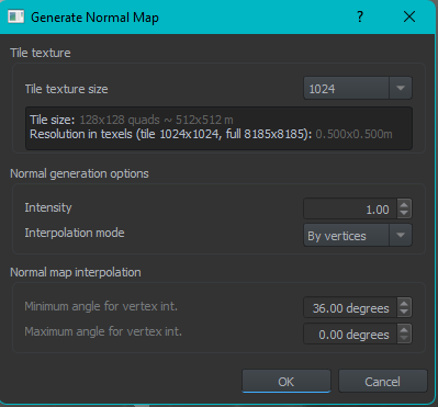
Is the 'tile texture size' correct? IE, the same as you're source heightmaps res?
rapid locust
now there's a good question, and the answer to that is I don't know. I have been using this website to get height maps:
https://tangrams.github.io/heightmapper/#14.75/43.5161/7.0516
but to be fair I have no idea what I'm doing with height maps at this point
feral olive
Right click the image in you're file browser and click 'details'
should tell you in there
Nah thats fair haha
rapid locust
Ah roger, that kind of res
so they need to be square
so If I set terrain size as 1024 then the image should be 1024
feral olive
It needs to be exactly what that drop-down says, possible the dropdown has a custom input? But I haven't played with it
grim tinsel
Did someone check how editor handles "non-island" terrains?
rapid locust
What should the Pixels/Inch be? 72 as standard?
feral olive
Not sure, haven't done it myself.
rapid locust
fair
neat trellis
rapid locust
Hi, I was just wondering if somebody could explain to me why my height maps are ...
Not entirely certain without being in the editor, but when importing your heightmap there's an option for minimum and maximum height. Tweaking that prevents the large differences in terrain you are having
 warm stirrup
I'm trying to use the same tools but coming up with very much the same results
rapid locust
Tools just crashed and now it wants me to locate the reforger project
sweet sedge
grim tinsel
Did someone check how editor handles "non-island" terrains?
Not possible
rapid locust
neat trellis
Not entirely certain without being in the editor, but when importing your height...
I'll mess around with that, thank you
rapid locust
rapid locust
Tools just crashed and now it wants me to locate the reforger project
Of which I can not
left tangle
turbid plover
I have seen that. But it just puts the camera in the ground and I can't move at ...
 sweet sedge
No landlocked terrain n yet. Only island unless you want end of the world drop
warm stirrup
Blud, any tips on height map importing from tools such as Tangram?
left tangle
rapid locust
Hi, I was just wondering if somebody could explain to me why my height maps are ...
is Terrain entity zeroed on 0 0 0 coords?
sweet sedge
Use ASC format
whole onyx
How do you implement water flow from a higher point on a map?
whole onyx
Ah, might have missed it then. Thanks for the answer though
rapid locust
I'll get back you but i'm having an issue with reforger tools itself now
turbid plover
zinc ruin
ah right you need one or both of these(taken from eden) ... <@201264565680340992...
Thx, worked for me. But just for a while. I now still have those two managers and I could move around. Just that I suddenly can't do it anymore and the character/player is now just stuck.
rapid locust
I dunno if this goes into trouble shooting at this point but https://gyazo.com/c6ae0c1cce96dbb6566768adac4489a0
It lost itself after a crash
turbid plover
Try launching Arma Reforger and then the Tools.
grim tinsel
sweet sedge
No landlocked terrain n yet. Only island unless you want end of the world drop
Oh, that is a bummer
rapid locust
turbid plover
Try launching Arma Reforger and then the Tools.
Thanks that actually worked
rapid locust
left tangle
is Terrain entity zeroed on 0 0 0 coords?
Yes it is
rapid locust
sweet sedge
Use ASC format
how would I get an ASC, all exports come out as png
turbid plover
rapid locust
Thanks that actually worked
That should also be the fix for that message every time you get it.
rapid locust
thanks mate
sweet sedge
You can use png but it is not recommended
You will have to import.it a lot of times with different settings as it doesn't know min/max
feral olive
sweet sedge
You will have to import.it a lot of times with different settings as it doesn't ...
Is there geo tiff support?
sweet sedge
It is better to turn geotif into ASC in qgis
Or better yet a world.generator like instant terra where you can do important edits and resampling
I will share my personal workflow next week
feral olive
qgis give's a read out of
min height elevation:
max height elevation:
When you select an area to export (as the black-white gradient rescales to the selected area's max/min height)
Can this be directly entered into the terrain system, or do you have to fiddle with the intensity settings until you get something that 'looks' right?
Would be fascinating to see, cheers for that. Also I get a world generator would be beneficial but there is a great amount of real world high resolution (1, 5 and 10m) geo tiff data out there.
sweet sedge
Export to ASC from qgis and it is 1:1
With image formats, it is not accurate to the decimal as ASC and your source files must be exposed properly
World editor also exports ASC perfectly so you can use other world makers to work on your data
feral olive
sweet sedge
With image formats, it is not accurate to the decimal as ASC and your source fil...
Not 100% sure what you mean by that, any chance of further elaboration?
rapid locust
Is QGIS a better software for heightmaps?
sweet sedge
If you are a newbie, look at instant terra
rapid locust
fair
feral olive
QGIS worked great when I had been playing with it, never directly generated terrain (nothing like l3dt) but it handled 200gb tiff heightmaps like a champ
sweet sedge
There are modern game terrain tools that do everything very quickly and easily
200gb tif is a waste
feral olive
200gb due to the size of the area, this was a very large coastal area of real-world 1m heightmap data.
sweet sedge
You can only use 16kx16k
feral olive
Source file to be massively cropped to the area that you're map will actually be.
sweet sedge
Do that in qgis
feral olive
I had been.
 royal turret
left tangle
royal turret
left tangle
In regards to "Playing" in the world editor, I am getting this strange issue.
When I click play everything seems to be exceedingly dark, I stole what I could find from eden, but I still get the dark issue on my terrain. Does anyone have any idea as to what I might be missing?
https://ibb.co/1JKyj6W (This is what the issue looks like)
https://ibb.co/ncLggYM (This is my current Hierarchy)
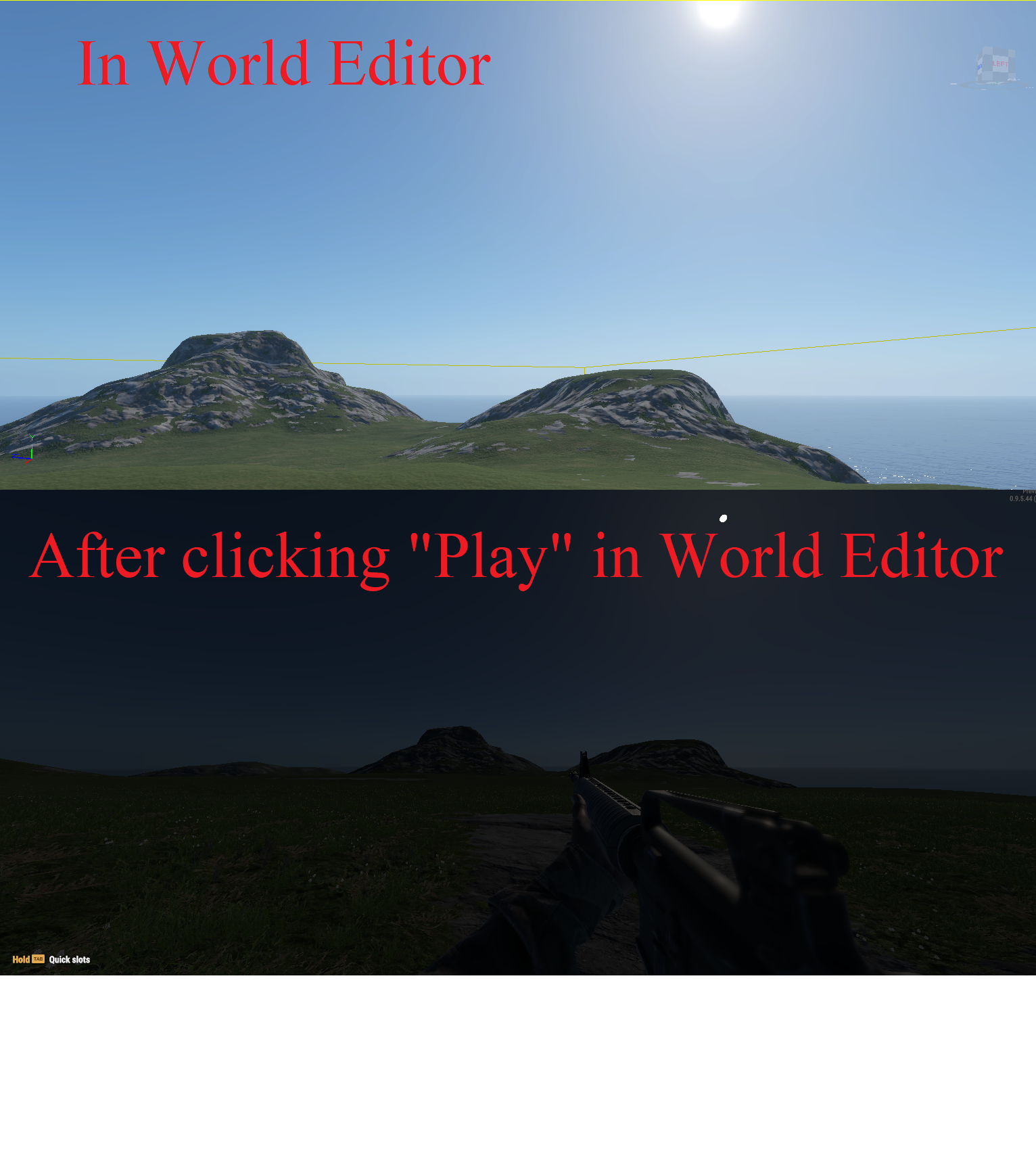
 left tangle
royal turret
In regards to "Playing" in the world editor, I am getting this strange issue.
W...
left tangle
royal turret
In regards to "Playing" in the world editor, I am getting this strange issue.
W...
check weather tool if you have it similiar to mine, otherwise i'm not sure right now
 royal turret
Thanks, I have it set as the same but it still seems to persist. I will play around some more, I am sure its probably just a number wrong somewhere
I fixed it!
https://ibb.co/3SpLLfR All of these are required
 whole onyx
left tangle
check weather tool if you have it similiar to mine, otherwise i'm not sure right...
whole onyx
left tangle
check weather tool if you have it similiar to mine, otherwise i'm not sure right...
Hey, regarding this. I seem to be unable to set a Master cycle even if I have the file for some reason. I am probably doing it wrong but what way would I go about doing it?
left tangle
whole onyx
Hey, regarding this. I seem to be unable to set a Master cycle even if I have th...
can you elaborate please?
whole onyx
I am having issues keeping my settings in the Weather tool so when I re-enter it resets even if I save a preset, I am also having issues setting a cycle. The bottom part of the image you sent.
I am sort of bad at explaining but I will probably figure it out.
left tangle
when you are in the weather tool, make sure to hit OK to confirm the changes
whole onyx
I was being a bit dumb, I mean more the date resets for some reason. Same with the Timezone settings. Cycle duration, Time and Update frequency stays the same.
left tangle
ah yes, because that setting is stored in the WeatherManager prefab you have in hierarchy
(at least that's my guess)
whole onyx
Ah, thanks for clarification then. It was driving me crazy
pine echo
does anyone know how to change your camera position by coordinates in the world editor?
i seem to have lost my position
left tangle
pine echo
does anyone know how to change your camera position by coordinates in the world ...
 feral olive
pine echo
does anyone know how to change your camera position by coordinates in the world ...
feral olive
pine echo
does anyone know how to change your camera position by coordinates in the world ...
Select something in the hierarchy and press f
left tangle
either F or double click on it in the hierarchy
turbid plover
left tangle
check weather tool if you have it similiar to mine, otherwise i'm not sure right...
How does one use that .conf file? I tried but it just won't let me use it.
feral olive
left tangle
Just gotta say, I love that you guys have even included this in the tools. Many game editors skip out on the smaller things that.
left tangle
turbid plover
How does one use that .conf file? I tried but it just won't let me use it.
documentation will be your best bet, i have no experience with it
pine echo
is the documentation up yet?
turbid plover
Why can't one send images in this channel? Seems very counterintuitive to block it.
 left cairn
https://i.ibb.co/qx6kdr0/22.png
How to smooth the steps? This is imported ASC heightmap
 feral olive
turbid plover
Why can't one send images in this channel? Seems very counterintuitive to block ...
feral olive
turbid plover
Why can't one send images in this channel? Seems very counterintuitive to block ...
Yeah I think a lot of these modding channels would benefit from it
 sweet sedge
left cairn
https://i.ibb.co/qx6kdr0/22.png
How to smooth the steps? This is imported ASC he...
sweet sedge
left cairn
https://i.ibb.co/qx6kdr0/22.png
How to smooth the steps? This is imported ASC he...
You this is from using images
You have to treat them right in qgis
Or other software
feral olive
sweet sedge
You this is from using images
Oh, is there no internal 'smoothing' tool for terrain in the editor?
sweet sedge
You also can do that
turbid plover
Doesn't work on that though does it?
sweet sedge
But it is best to do it every ght before you load source files
feral olive
sweet sedge
But it is best to do it every ght before you load source files
For sure yeah.
sweet sedge
It does work, use the brushes
turbid plover
turbid plover
https://cdn.discordapp.com/attachments/727972049313595406/976448090217283604/unk...

With this stuff
warm stirrup
left cairn
https://i.ibb.co/qx6kdr0/22.png
How to smooth the steps? This is imported ASC he...
hello dude
Im using Insta Terra and getting much better results
pine echo
anyone know how to increase world size
i imported a height map, but it doesn't fit into my current world boundaries
warm stirrup
 pine echo
woah
warm stirrup

Its significantly cleaner than PNG as Blud makes very clear.
only thing I've got to nail down is the scale is abit 'off'
sweet sedge
iti s easiest to use a purpose made terrain simulation and sculpting tool to at the very least process your height map
because you also use that data to generate masks
I am working on some sample files for the community and am using instant terra to create those actually
warm stirrup
lovely cheers
 frank iris
What is maximum resolution for arma terrain?
sweet sedge
16k
warm stirrup
still gonna explore the F out of it, enjoying the tools
pine echo
sweet sedge
I am working on some sample files for the community and am using instant terra t...
Do you then import the finished terrain file as an asset?
sweet sedge
no
you import the data you need. such as the heightmap
then you use the simulation tools to generate your masks
frank iris
sweet sedge
16k
Cheers
feral olive
sweet sedge
16k
Is this dependent on world size, or a cap in software?
sweet sedge
see this?

i export that mask and that is all i need for defining rock surface on my map
pine echo
Oh I see what you mean
sweet sedge
then you just force import that into your rock surface and you are set
pine echo
Gotcha, I already have a heightmap
sweet sedge
it is recommended to do this with your 3 most important surfaces on your map
then hand paint the others
so basically underwater default texture, rock and grass
everything else you just paint by hand as you place things
this is the same island
 pine echo
You can import colorized height maps into enfusion?
sweet sedge
in my workflow, i would use that data to paint my own sat map inside photoshop, using the distant ground textures in contextual locations using those masks inside photoshop aswell
no you just export it as sat map files
however you want
there are several ways you can do colour grading of it once you get the hang of it
pine echo
Ok ok, sorry if I'm a little slow at this, all new to me. I'm a programmer but new to engines
 eternal fractal
Whoa this satellite map thing is nice
whole onyx
Might have to give Instant terra a try
 empty sluice
left cairn
https://i.ibb.co/qx6kdr0/22.png
How to smooth the steps? This is imported ASC he...
empty sluice
left cairn
https://i.ibb.co/qx6kdr0/22.png
How to smooth the steps? This is imported ASC he...
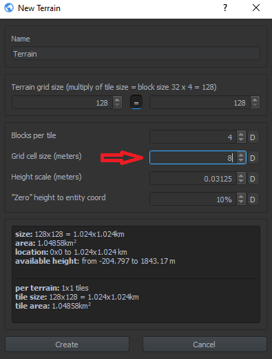
after you press create terrain, in the setup box you need to raise the grid cell size...
won't let me post a picture.. otherwise i'd show it
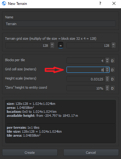 zinc ruin
empty sluice
after you press create terrain, in the setup box you need to raise the grid cell...
zinc ruin
empty sluice
after you press create terrain, in the setup box you need to raise the grid cell...
well that's not really a good way ... I mean you sacrifice terrain resolution to get smoother look
empty sluice
is there a better way?
zinc ruin
first let me understand what file you trying to import
rapid locust
Was wondering if anyone knew how to add water to the world?
like the base sea level
rapid locust
I think thats more for ponds
empty sluice
zinc ruin
first let me understand what file you trying to import
so far just trying with an .asc heightmap.. have considered giving a png height map a try.. but TB never did well with those.. so haven't tried yet
zinc ruin
can you share asc file?
rapid locust
zinc ruin
https://discord.com/channels/105462288051380224/976159873517629500/9764069201203...
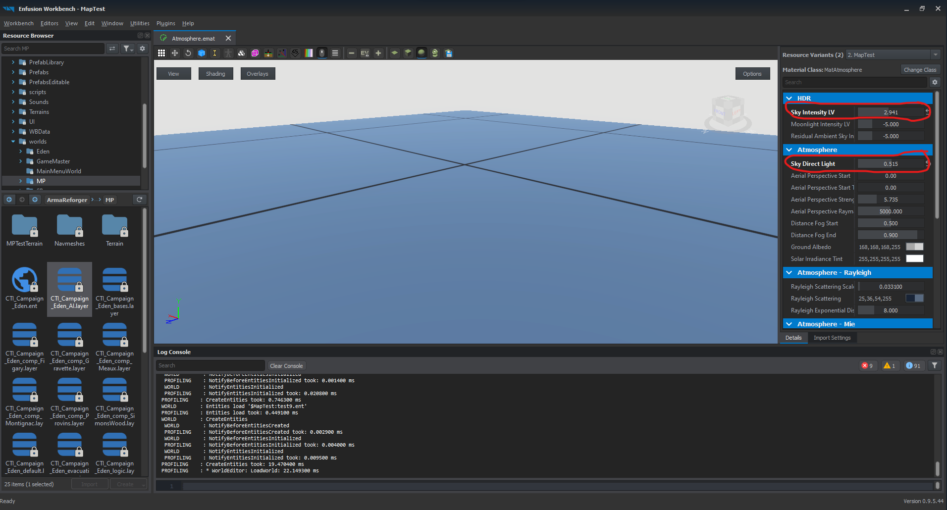
Done most of that but its mega bright, could it be something in those presets?
warm stirrup
yeah its blinding
zinc ruin
rapid locust
Done most of that but its mega bright, could it be something in those presets?
screenshot maybe ... just DM it
 rapid locust
zinc ruin
screenshot maybe ... just DM it
rapid locust
zinc ruin
screenshot maybe ... just DM it
Nah all good now, managed to figure it out
but thank you
Another question now, I seem to be limited as to where my camera goes, is this a setting? and is there any way to extend my view distance?
 austere shell
rapid locust
Nah all good now, managed to figure it out
austere shell
rapid locust
Nah all good now, managed to figure it out
how did you fix it?
austere shell
rapid locust
Another question now, I seem to be limited as to where my camera goes, is this a...
after saving and re opening it worked with camera bounds being correct
rapid locust
austere shell
how did you fix it?
For starters I clicked this
https://gyazo.com/733e0646ddeb8786645a2e1ce9457d98

It switched me to another editor

I then selected a secondary resource value
I then edited these 2 values till it was some-what bearable
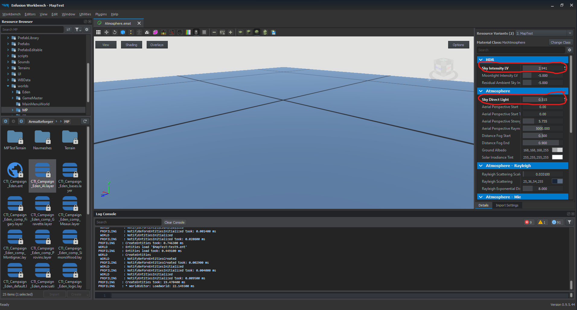
Then you hit save
 woeful osprey
What are you guys using to get your height maps?
Want to start working on a terrain so I know how to do it in the future but what would be the starting point? I'd assume the height map but then again I've only messed with Unreal lol
neat trellis
woeful osprey
What are you guys using to get your height maps?
They're either from online sources, there are websites where you can select an area and get the heightmap from it, or generated using software like L3Dt
woeful osprey
okay so similar to Unreal engine then
neat trellis
If Unreal Engine can take in heightmap data, sure
woeful osprey
I was saying its similar to the Unreal engine Terrain creation thing but yea.... long story short trying to figure out how to do stuff in this workbench and just like uhhhhhh xD
neat trellis
Eventually I am sure people will make comprehensive tutorials to do everything, until then people are in the same boat
woeful osprey
yea I've been reading thru this all day xD
 noble cloud
yeah spent hours lastnight just working out how to get terrain in then fixing its collision it was missing for some reason lol
woeful osprey
i'll probably work on it this weekend, My end goal is to make a "Training Terrain" that will be suitable for Infantry based stuff, Vehicle based stuff, and some long flat areas to be used later for Arma 4 (Jets & Helicopters)
rapid locust
QGIS is brilliant for height maps
and there are a few youtube vidoes that are easy to find that show how to use it for arma
sweet sedge
Tomorrow or Friday we will have a sample terrain out. It is an OK sized island anyone can build on and do what they want with. It will only have basic nature, masks and everything and every type of generator and function used and modifyable
grave basin
Will there be documentation also on how to implement terrain as well or is that coming at a later date?
noble cloud
whats the max size of terrain u can do? i seem to always crash it when trying to do 8x8km terrain creation. ?
blocks per tile : 2
Grid Cell Size : 8
Grid Size 1024 x 1024. ..
crashes on that tho
left tangle
noble cloud
whats the max size of terrain u can do? i seem to always crash it when trying to...
- max limit is for you to find out
- make sure to save the map outside of Reforger folders (with the small lock icon)
noble cloud
put blocks per tile to "4" and it worked. so max ive got out so far is 8x8km
left tangle
noble cloud
put blocks per tile to "4" and it worked. so max ive got out so far is 8x8km
i tried 32k and it worked fine, you need to play with the various values present in the terrain creation window
noble cloud
yeah seems it doesnt like some settings and crashes out . will keep messing with it. 🙂
left tangle
As I've said, please make sure to save the world somewhere else than the Arma Reforger folder. 🙂
noble cloud
yeah have done. its in its own folder out of the locked stuff
left tangle
The issue with the saving crash is reported and should be hopefully fixed in an upcoming version of the tools. 👍
noble cloud
yeah its all good 🙂 starts back up fast atleast lol
 kindred goblet
How does the hand painting work, Im familiar with UE4 editor, but cant figure out how to do actually the painting
got materials already in there
 odd wren
Managed to do a simple terrain. Once I figured out how not the most intuitive tool set but 100x better then modding a2 lol next is materials I guess
kindred goblet
oh lol never mind figured it out
sweet sedge

 desert igloo
whats a good way to place enough trees to have a forest
i mean i can place em 1 by 1
but isnt there a way to brush them or something?
odd wren
Just noticed this but i cant seem to move from corner to corner of the map? invisible wall!
noble cloud
world bounds
desert igloo
i dont know what polyline is
mental lion
Can someone recreate the state of Rhode Island? 1:1? That place could use a small war
kindred goblet
turbid plover
https://cdn.discordapp.com/attachments/727972049313595406/976449968808275988/unk...
Cant find this
odd wren
Where do you change the world bounds :. Not seeing anything happen when i click would bound tools
river chasm
@desert igloo did you figure it out or do you still need some help?
desert igloo
i need some help still
raven lance
Are there any transform options for the satmap? I imported mine and it appears to either be offset slightly, or rotated. Hard to tell. 🤔
desert igloo
DM
left tangle
Sorry Aaron if I'm faster, for everyone, how to create a forest (and much more);
- Select Vector Tool
- Click on New Polyline
- First left click into the scene, then Ctrl+LMB adds point in front, Alt+LMB click at back
- Once you are done, go to object properties and check Is Closed box (at the bottom)
- Look for FG_ in Prefab Library or Resource Browser
- Find what forest you are looking for and drag'n'drop it right into Hierarchy in WE straight onto the vector
- You have a forest
You can edit vectors only while in Vector Tool.
noble cloud
Is there a reason why if ur terrain is not at 0,0,0 it has no collision?
river chasm
@left tangle all good!
left tangle
noble cloud
Is there a reason why if ur terrain is not at 0,0,0 it has no collision?
Not sure exactly why, but it is a certain "limitation" we have.
kindred goblet
Alright got the lighting sorted, trying to playtest it on editor cant move or am I missing spawn entity or something?
noble cloud
ok was just making sure i wasnt going mad 😄 lol
one last quesiton lol. the invis walls in the editor., anyway to edit them? as when terrain is at zero. it pokes out at one end so cant get to that end.
raven lance
Save and close the editor, and then open it again. Seems to recalculate the world bounds then.
noble cloud
cheers
raven lance
@left tangle Am I correct in the assumption that those numbers should be the same?

Currently have the oddity that things are offset. 🤔

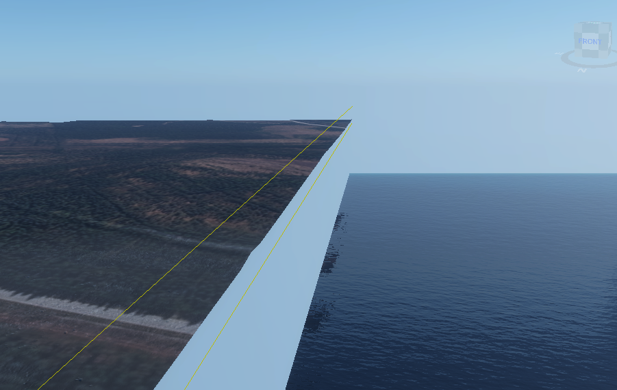 river chasm
perfect
kindred goblet
Maybe this is the reason I cant play it 😛
sweet sedge
noble cloud
one last quesiton lol. the invis walls in the editor., anyway to edit them? as w...
Reload the map..when you change a heightmap, you gotta
It is good practice to do that often
fringe pasture
raven lance
Currently have the oddity that things are offset. 🤔
heightmap imported wrong? There is a flip x or y checkmark that you need to do. Or is it a different issue
raven lance
Not sure, I unchecked the flip thing.
fringe pasture
I think the flip might be required
raven lance
Interesting.
I find it more strange that the resolution calc for the satmap does not match the overall map size.
raven lance
fringe pasture
I think the flip might be required
A flip on both X and Z. (Engine uses Y axis up) appears to have sorted things out. 🙂
sweet sedge
raven lance
<@201264565680340992> Am I correct in the assumption that those numbers should b...
no
it resamples your source to what it needs
so the size you see there is what you want to make your source hf from then on
if you settle on that res
flat owl
is there any way to increase the render distance in the World Editor?
Or to at least restrict the fog?
raven lance
Camera settings tab at the top of the viewport.
Min and max clip ranges change when things clip out of view.
so the size you see there is what you want to make your source hf from then on
Interesting...
flat owl
So I'm having an issue rn
Whenever I import my sat map, my editor keeps crashing
This is the image, and i'm importing it onto a 512x512, ~25km^2 map
I've gotten the height map working properly, but the sat map is causing me my issues now
 paper arrow
Is there any tutorial or resources for creating a sat map from instant terra data? I have my masks for rock + grass etc but no satmap for distant textures
sweet sedge
ill have a smoll guide for it later how to do it the most basic ways incl the files
but what you should do is export masks
one for each surface that you would use to generate the basic nature.
then import those
 primal lark
How do you make roads?
sweet sedge
then import those as layers or masks in photoshop and fill them with the average colours from the ground texture middle textures
flat owl
primal lark
How do you make roads?
You need to create a spline using the vector tool
sweet sedge
how to make roads has been explained a few times if you scroll up
flat owl
or that too lmao
flat owl
sweet sedge
then import those as layers or masks in photoshop and fill them with the average...
Any recommendations on getting those aforementioned masks?
Or generally, how would one go about creating them?
sweet sedge
the search function is your friend. we have gone over all the tools already for by far not the last time 😄
flat owl
Hahah fair enough
sweet sedge
in instant terra there are like 10000 things you can do to make masks
not even kidding
they have videos and tutorials for all of them and guess what.. it is called masks in instant terra too
just import your heightfield. you can export it from enfusion with roads and everything
then you can do some serious mask business in IT
or l3dt
or photoshop
flat owl
Awesome, thanks blud, i'll take a look




 river chasm
keep going 
 tawdry elk
I've made a custom terrain using l3dt and have imported the heightmap to the terrain but for some reason it has no collision?
flat owl
Holy hell, Instant Terra is amazing. Thank you @sweet sedge, I now have a new program to get addicted to
noble cloud
what do i need to change to increase distance u can see the ground texture? its white further away.
grave basin
Anyone else crashing when importing a heightmap file?
sweet sedge
I'm the.material
 hexed cape
flat owl
Holy hell, Instant Terra is amazing. Thank you <@135542085095915520>, I now have...
hexed cape
flat owl
Holy hell, Instant Terra is amazing. Thank you <@135542085095915520>, I now have...
Gaea is also very good terrain creator. There is a free version on their site.
sweet sedge
If you crash when Importing height map. Try other settings. It.csn be whatever reasons
grave basin
sweet sedge
If you crash when Importing height map. Try other settings. It.csn be whatever r...
Alright thanks I'll mess about
hexed cape
I have my heightmap imported but how does one put a material on the surface such as grass?
tawdry elk
hexed cape
I have my heightmap imported but how does one put a material on the surface such...
I've figured out that if you go to paint mode in terrain tools you can drag and drop textures into the open area and then paint brush them onto your terrain
hexed cape
ty, will try!
sweet sedge
That is also where masks are imported
hexed cape
One more question. How do I up the view distance so I can see more then what looks like 500m of my map before its lost in the fog?
raven lance
hexed cape
ty
sweet sedge
ben is going to do this a few thousand more times before it dies down
100% accurate estimate
short helm
@sweet sedgedid you use Squadspinne for your map or Scuplt by hand?
sweet sedge
no idea what squadthingy is and also which map?
short helm
sweet sedge
if anyone know my A3 maps they might recognize this:
this
it look amazing
Im talking about this

QuadSpinner is the creator of Gaea, the most loved terrain design tool for VFX, games, and virtual experiences.
Terrain generation
sweet sedge
oh right
someone gifted me that software
long ago
i wish they hadn't and that is all i am gonna say about it
hexed cape
I use the free version lmao
sweet sedge
some might like it
sweet sedge
i recommend this personally: photoshop, qgis and instant terra
hexed cape
Can not figure out how to add a skybox for the life of me.. fml
short helm
Neither I
sweet sedge
qgis for working with map data
turbid plover

 sweet sedge
if you dont recreate real terrain, you dont need it at all
sweet sedge
you can juse use instant terra and enfusion
turbid plover
turbid plover
https://media.discordapp.net/attachments/727972049313595406/976557691008843837/u...
So uh is it normal that one has to change the Enviroment Probe Entry for every new building placed down?
left tangle
turbid plover
So uh is it normal that one has to change the Enviroment Probe Entry for every n...
I think there is something wrong with your lighting, you shouldn't be touching probes at all (to make them work).
turbid plover
ok
cause I somehow managed to get my general lighting to not look way to bright and white
but basically with trial and error :/
Is there an ETA on the terrain documentation?
 pulsar lodge
turbid plover
Is there an ETA on the terrain documentation?
pulsar lodge
turbid plover
Is there an ETA on the terrain documentation?
likely when possible. Patience.