
#Weather and geological phenomena
1 messages · Page 5 of 1
Fuck
Melissa Likely to Stay South of Jamaica and Become a Category Five Hurricane by Monday Evening:
︀︀
︀︀Although tropical storm #Melissa remains a heavily-sheared and vertically misaligned system, it’s this lack of structural integrity that will likely cause it to miss hitching a ride with a passing mid-latitude trough to the north (in contrast to what has been persistently predicted by the more easterly model solutions such as the GFS) and have that corridor closed as the ridge builds back in and imparts a westerly to west southwesterly steering flow in about 48 to 60 hours. In the meantime, very weak steering currents should result in a slow northwesterly or north-northwesterly movement towards the aforementioned weakness. Despite this being by far the most probable scenario (80%), a more northerly to northeasterly track towards Hispaniola can’t be completely ruled out (20%). But, as noted above and over the past couple of days, that would require Melissa to be…


very long post, would rec. the full read.
Very bad trend for TS Melissa


Model output if you want to look at it


More and more models are suggesting a potential worst case scenario of it stalling out SW of Jamaica, intensifying, then turning NE.

I'm so concerned about storm surge.
Specifically these two areas- Primary concern is marked in pink,

Closer zoom of the two areas,


Old Harbor Bay+ Tarentum are my primary surge concerns, although Saint Andrew/ Kingston could easily see issues.
I could easily see 12-20(+) ft of storm surge occurring if Mellissa ends up taking the exact current estimate, which at that rate, even if your home doesn't get swept away- you would on the roof.
The worst thing is that- due to how slowly the system is moving- these conditions could worsen (and be maintained) for potentially a few days.
NOAA Hurricane Hunters returning to base after a flight through #Melissa. https://t.co/uKJ4mDmT62


Thunderstorm: exists
Texas power grid: “my job here is done. Goodbye yall on your own”
No wonder why my Google Home shut down 
(There is a minor chance of seeing a tornado today or tomorrow, i'm personally got my eyes on the Del Rio area)


(Well now that i look at the models again, switched to ol' reliable, Fort Worth-Dallas.)
Well fuck 
Good reason to get me Meshtastic devices charged
If shit happens, get to highest point and turn on the devices
We're looking at will likely be an unprecedented catastrophe for Jamaica if these trends continue. (Highlighting by me.)


You should be a paid meteorologist at this point, wtf
The closest match to a prior event I can find would be Hurricane Gilbert (1988), Hit the island head on at high end Category 3, producing a 19 ft storm surge+ an additional 32 inches of rain, "Unofficial estimates state that atleast 30-70 people were killed [varies a lot], and had estimates that "500,000 people were left homeless" (per https://www.upi.com/Archives/1988/09/16/The-nations-official-death-toll-from-Hurricane-Gilbert-climbed/9643590385600/),
The population of Jamaica at the time was 2 million.

Of course- massive change in the area since, but it is also of note that the current path for Mellissa is further south, which I would expect to increase storm surge risk due to that local geography (water being shoved further and further into the bay, and not being able to get back out until the system moves on somewhat)
I am concerned that 20+ft of storm surge may be seen from this system for parts of Jamaica.
For additional context in terms of a "recent USA equivalent", Hurricane Ian (2022) of 10-15ft for parts of Florida. (Had predictions of 12-18 ft before landfall), this is typically considered unsurvivable without pure luck if you were in low lying areas.
Hurricane Milton (2024) had a max of 10ft S of Tampa, (Predictions were 12-15ft for Tampa, lucked out due to a change in pathing, which ended up drawing water out instead of pushing more in, i have a graphic I made in...probably this chat explaining that somewhere, will try to find)
Realistically, 10+ inches of storm surge is certainly on the table, 20 is upper end worst case in my eyes.


Expecting tornado potential to kick up in a few hours, (3-4 maybe? Most of the FW/DAL area shouuuld be aight for tornado risk, maybe southern Dallas could see something?)
(But overall, lookin at decent wind gusts+ lightning for that area's general risks imo)
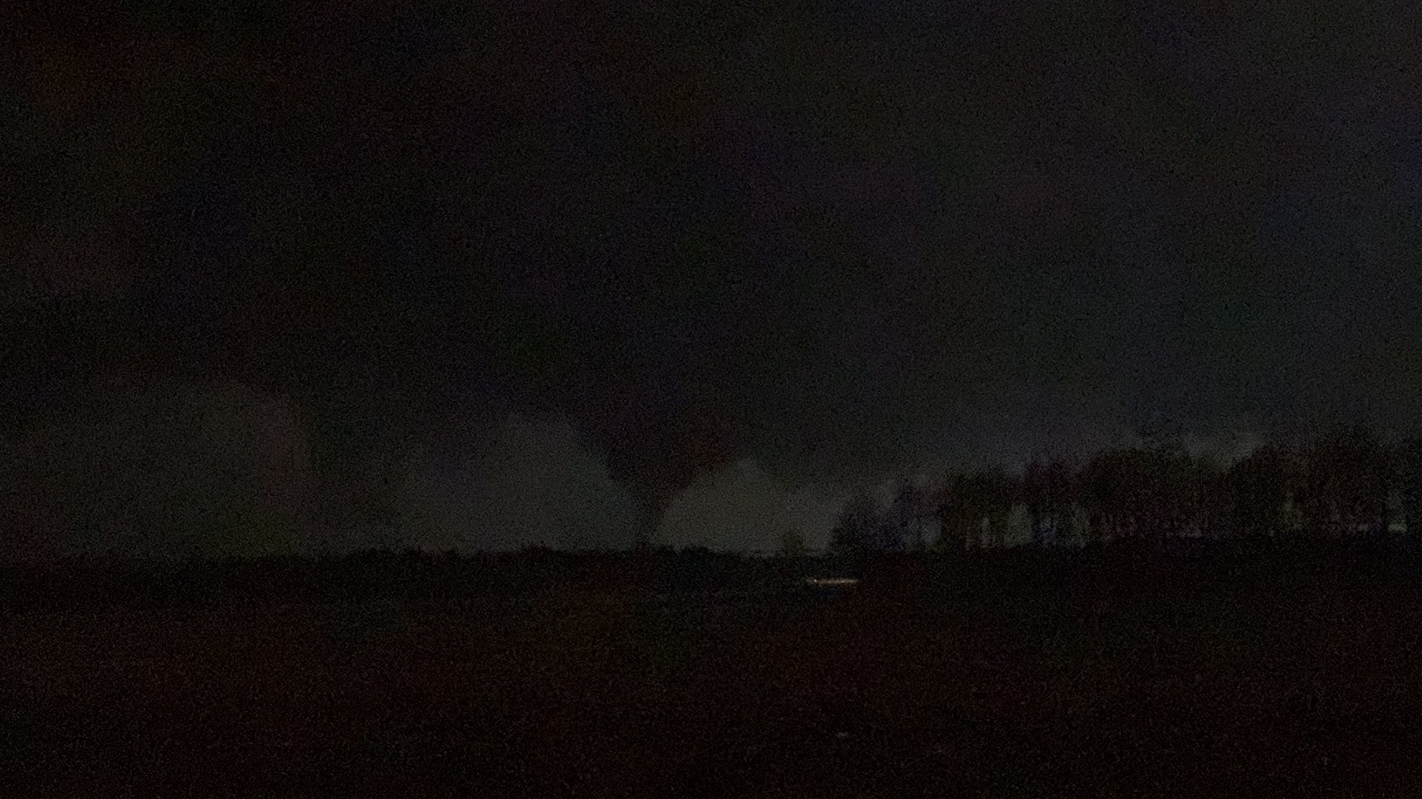
Likely a brief tornado occurred close to Fort Worth,


I mean honestly you get the one wave and then you're aight for the night (Unless flooding is a notable concern for ya.)
QLCS setup,
Sounds like a decently strong tornado occurred near if not over TCU's campus.
Reports of powerlines downed+ 1 "potentially collapsed structure" (First responder report, always sketchy)
(^Update on this- sounds like a building had roof damage? Hate y'alls scanner tbh, i can never get the levels right, but likely not a "collapse" like initially reported.)
geolocating damage for a NWS office at 1 AM 🙃


...This is a new worst case scenario I haven't thought of- specifically if you're concerned about storm surge in Kingston...

...It'd be held in the front right quadrant (Worst spot to be) for like 2 days if this ends up 100% verifying

If the forecast holds- I am extremely tempted to make a thread for this thread focusing on the impacts and recovery of Jamaica in the (bare mininimum) months to come.


Breaking: Melissa is now a major hurricane! Category 3 with 115 mph winds.
At 11 a.m. ET, it was a 70 mph tropical storm.
That means it's intensifying at DOUBLE the rate needed to classify as "rapid intensification."
Likely to be a Category 4 by sunrise, if not soone.r


National Hurricane Center Deputy Director Jamie Rhome provides a LIVE update on Major Hurricane #Melissa. The Atlantic hurricane season continues until November 30.
Follow us on social media to get the latest updates! Stay tuned for posts during tropical events and LIVE updates on Facebook, YouTube, and Instagram.
Facebook & YouTube - @ NOAA/N...

Great lil graphic, but this is why storm surge specifically concerns me.
Some of the responses i'm reading from Jamaicans (mainly via Twitter,) are very... Katrina-esque rhetoric, for lack of a better term, "We'll be fine- we've gone through this before", "There's nowhere to evacuate to so i'll stay home" (in a low-lying area), etc.
"The rainwater will flow away, we're built for this" ("this" being a 10th of the rainfall that is projected)
I fear that the absolute worst case scenario is unfolding. (A significant impact+ a notable swath of the population not taking as many precautions that could have been done)
...After Katrina, back in 2005, bodies were being recovered from floating in the streets for weeks, there's still 600+ people unrecovered from that one, 20 years later.
The best comparison I can tie this to is that this looks like it could very well be Jamaica's Katrina.
And I know that gets slung around quite often from newer members in the community- but i genuinely believe that the level of human anguish that will be seen in the coming weeks/ months will be comparable.
BREAKING: The Jamaica government issued a mandatory evacuation order for specified vulnerable communities, effective immediately, amid major Hurricane Melissa:
1. Port Royal, Kingston
2. Portland Cottage, Clarendon
3. Rocky Point, Clarendon
4. Old Harbour Bay, St. Catherine
5.

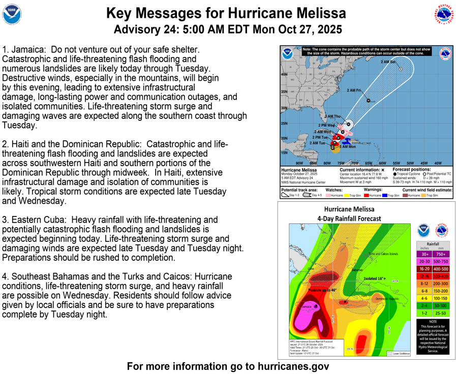
10/27 5am EDT: #Melissa has strengthened to a Category 5 hurricane with 160 mph winds and a 917 mb central pressure, confirmed by the Air Force Reserve Hurricane Hunters. Conditions in #Jamaica will rapidly deteriorate later today and tonight. Here are the key messages:
See

Almost unheard moment where Hurricane Hunters aircraft had to leave the storm to ensure the safety of the crew and airframe.

Just to clarify on the announcement- as long as Melissa is actively a threat to Jamaica+ surrounding countries- it will be in here, with coverage focused on the system itself, and i will try my best to preface each update message w/ the name of the system, so searching later will be easier,
When we start moving towards a extremely long term coverage of the direct aftermath and recovery for the island (Which may shake up political aspects) - that is likely when it will get it's own thread in Regions.
Best case scenario, one will not be needed, it depends on how this ends up occurring (And for lack of a better term, the "vibe" of how much impact it has on a national/international scale), we may not know the full extent of damage as far as the 29th in my opinion, depending on how well the underlying communication/power infrastructure holds.
(Excuse my typos- just woke up, just a breakdown of my thinking of why a thread may be needed, and why one isn't quite up yet, because it will sorta move out of the strict "weather" box i've made for myself here)

📱 FREE WEATHERWISE RADAR APP:
• iOS: https://apple.co/44wDDKH
• Android: https://bit.ly/42RyZEu
• Browser: https://web.weatherwise.app/
• Main Site: https://www.weatherwise.app/
• WeatherWise Tutorials: https://www.youtube.com/@WxWiseApp
🛒 SHOP MERCH:
• Weather radios, Y'all-O-Meters, and more at https://shopryanhall.com
...
Landfall is not expected for many hours- but a good livestream going over the Hurricane Hunter's readings.
I have however noticed that Melissa has not quite turned to the NE as quickly as forecasted,
Forecast models vs where the path has been so far (Black X for recorded positions of the eye)
(00Z run w/ verif. for all positions up to 18Z)

it has currently overshot what I would consider to be the "majority" of the model consensus, waiting to see how this run fares in the next few verification cycles.
(18Z run)

Similar concerns can also be seen for the intensity forecast, (1st image is the 0Z run, 2nd is the 18Z run)


For context- as of this post, it is 22:48Z,(24HR format) next time I can pull this data is at 0Z.
Fun little side note- the reason why the NWS uses military time is because the NWS initially was a part of the military!
Also, it just makes more sense. 😉
decently long thread with videos from the Hurricane Hunter flights recently
(I certainly recommend looking at all of them, especially this one.)
https://fxtwitter.com/FlynonymousWX/status/1982915178221191411

Third pass through Melissa. GoPro in side window as different camera looking forward shooting in ultra high res 8k. Not sure when that might get processed as the file turned out ridiculous. Barely had HD space for it and MacBook Pro promptly chocked when I tried to edit it

Join us for LIVE coverage as the Government of Jamaica provides the latest updates on Hurricane Melissa — its projected path, national preparedness measures, and critical public safety information. This broadcast aims to ensure that every citizen is informed and prepared as Jamaica continues to monitor and respond to the evolving weather situa...
3 fatalities reported in Jamaica already relating to preparations for Melissa
13 injuries reported.
Well, it's no longer moving W.


18:41 vs 19:51, no movement. (Maybe 0-1 MPH NW?)
If you're interested in the geography that is behind the concerns for the flooding/mudslide risk, i can only recommend this video by TheGeoModels,
https://www.youtube.com/watch?v=QQ4a_01mGQY

Hurricane Melissa will be disastrous for Jamaica, and the island's rough topography will make inland impacts even worse. Jamaica is home to huge mountains and crazy rivers that will explode with the predicting rainfall amounts from the slow-moving storm. This video shows some elements of the central and eastern Jamaican landscape that will make ...
LORD... this thing refuses to stop intensifying. I mean, meteorologically WOW. Hurricane Melissa now has 175 MPH sustained winds with wind gusts to 215 MPH. It probably will strengthen more overnight. There will be a path near the center of tornado like damage and near total

....they had a 240 MPH wind gust recorded, decent ways above the surface, but within "mountain" territory heights.
Geolocated initial flooding video,
@pjdohertygis @sainty876 I have my suspicions this is at "Oswald Seafod Restaurant & Bar" (17.86793299559531, -77.56526556685317), Certainly in this "rough area" given the terrain.
**💬 1 👁️ 6 **


About 2 hours until landfall. It looks like Alligator Pond will be the area to watch.

Someone did a video here:
https://bsky.app/profile/stevebowen.bsky.social/post/3m47utsq33c2d

What we're witnessing with #Melissa is ultra rare in the history of known hurricanes in the Atlantic. This level of sustained intensity and feasting on every joule of ocean heat content without any real disruption is incredible.
Not hyperbole: Jamaica is facing a generational catastrophic event.
Reposts
2616
Likes
5499
Quotes
424
Replies
263
(prolly tack on another hour to this estimate, didn't accelerate as quickly as I assumed it would.)

Gizmodo
Seven live video feeds from locations all over Jamaica. Whatever the original purpose may have been, any live video feed can become a valuable resource.

SkylineWebcams
View from Barbican Square in Kingston, Jamaica Live cam
Recon has found an extrapolated pressure of 893.5mb.
Unbelievable.
#Melissa

Live Beaches
Jamaica Webcams View live webcams in Jamaica and see what’s happening at popular beach resorts in the Caribbean. Check current weather conditions, enjoy scenic views of the beaches, and discover the best places to visit. Jamaica Vacation Packages Popular Islands in the Caribbean Jamaica Cayman Islands The Bahamas U.S. Virgin Islands Br...
we are here-ish.


Still waiting for this flight to conclude- they may get some more readings, pressure dropped notably since the last probe. (Signs of it continue, or, had continued to intensify over the past few hours)
Would watch for reports of tornadoes as Melissa starts to cross over the island.
Could see a notable uptick in tornado reports for multiple island nations in the area today, to be honest, Primarily Haiti with those outer bands.
Personal assessment given the current pathing.
Significant wind risk- Black River, Billy's Bay, Calabash Bay, [potentially up to] Auchindown. (A notable portion of structures could see some degree of major failure, [roof or more])
Significant storm surge risk- Alligator Pond, Gut River, Fraquhars Beach, . (A notable portion of structures could see notable water ingress (10+ ft entirely possible.)
UN support prepped for Haiti https://news.un.org/en/story/2025/10/1166194
ODPEM have opened shelters : https://www.odpem.org.jm/weather-alert-melissa/

UN News
Millions of people across the Caribbean are bracing for the impact of Hurricane Melissa as it reached Category 5 status on Monday – the most powerful on the scale – defined by sustained winds of at least 157 mph (252 kmh).
Support pledges coming in from various places (does this storm need its own thread?)
https://www.jamaicaobserver.com/2025/10/27/eyeonmelissajamaica-receiving-pledges-support-pm/

KINGSTON, Jamaica - Jamaica has been receiving pledges of support for hurricane preparation and recovery from its regional and international partners, says Prime Minister, Andrew Holness. “We have received calls of support from our partners – the United Nations, United States, the British, the French, the European Union, the Caribbean Disast...
It looks likely that the recovery will get one, had a mini discussion about that decision yesterday.
Oh sorry. Been pre-occupied so missed it
It's back up here if you want to read through my reasoning for that.
Forward speed has more than tripled to 7 MPH (Was at around 2 MPH), expecting that to accelerate further later, (Likely once it gets past Jamaica.)

New pass, 892.5 mb now.
Landfall is likely occurring very soon if not now

Most recent dropsonde measured 252mph winds just a couple hundred meters above the ground.
This is important to note, as many areas of Jamaicas coast are elevated / hilly.

9:35 am. Crashing sounds —like an explosion. Wreckage flying down the street. Trees bending way over. Very unpleasant pressure in the ears. #Hurricane #MELISSA in Crawford, St. Elizabeth Parish #Jamaica
Anyone seen storm surge estimates? Is the water too deep for significant surge? Some of these western areas look relatively low-lying
Water really high already

Watch Flat Bridge Jamaica LIVE 24/7 and experience one of Jamaica’s most historic and scenic landmarks in real time. This live camera shows the Rio Cobre River and constant traffic over the Flat Bridge, located in Bog Walk Gorge, St Catherine. Known for its stunning views and unpredictable river flow, Flat Bridge remains a vital link between S...
That is flooding from rainfall headed downstream
18.06136916149487, -76.98461373525544
It is.
The hurricane has just hit land, looking at sustained winds of 185mph!

BBC News
The US National Hurricane Centre warns of an "extremely dangerous and life-threatening situation" as the violent category five storm hits the island.
Residents across Kingston, St Andrew, St Catherine and St Thomas are being urged to exercise extreme caution as heavy rains and flooding associated with Hurricane Melissa may drive crocodiles out of their natural habitats into communities.
Cave valley, St Ann
House Submerged
#TrackingMelissa #HurricaneMelissa #Jamaica @CVMTV


Yo this is at least a 2 storey house (upstairs and downstairs) which is anywhere between 16 - 25 feet. 25 feet of fucking water. God of Daniel, what is this?
Extremely significant damage reported in Black River, Jamaica.
We haven't heard from Morgerman since landfall, his service is likely fully out, was last known to be in Crawford.

Jamaican government minister: "The parish of Saint Elizabeth is under water. The damage to Saint Elizabeth is extensive." (Saint Elizabeth Parish population is around 150,000.)
(from press conference)
Quarter of one cell networks down https://www.jamaicaobserver.com/2025/10/28/eyeonmelissa-digicel-says-26-mobile-network-offline-vaz/

KINGSTON, Jamaica — Telecommunications company Digicel reported 26 per cent of its mobile network as being offline Tuesday morning, in large part due to the widespread loss of power. “There’s a further 209 sites running on generators and nine on batteries. For fibre to home (cable) customers, we’re seeing 20 per cent [of] customers offli...
Worth noting that there is no river to speak of in this area, on the opposite side of the island as the storm. It's a tiny stream.
The bumpy karst topography is literally just filling up in the low points, like when you make ice cubes with a tray
The water can't escape by rushing down a river because it usually just seeps into the ground.

What Hurricane Melissa has left behind
︀︀Brigade Street
︀︀Black River, St. Elizabeth, Jamaica
I'm extremely concerned that Melissa is undergoing rapid intensification – or I suppose rapid reintensification – again as it approaches Cuba.
The core/eye have RAPIDLY reorganized and the EEL – Enveloped Eyewall Lightning – signature has re-appeared.
Cat-4 impact possible!


Black River Anglican Church...built in the 1700s...gone. I was christened in that church. My grandmother and I used to go to church every Sunday as a child. My mom still has a certificate my grandmother got from Sunday School in 1937. 😢😢😢.
Still concerned about communities on both sides of Black River,

Still internally debating on if a recovery thread is needed,
This has been absolutely catastrophic, but we did avoid the worst case scenario (it deviating more the the E like the initial track had.)
Government is already pretty organized with a (what seems like) a solid plan to rebuild quickly

11pm EDT: After weakening while crossing over Jamaica, Hurricane #Melissa has strengthened some and re-organized, with its eye becoming better defined as it approaches Cuba.
︀︀
︀︀Melissa is now a category 4 storm. Conditions will continue to deteriorate across eastern Cuba tonight.

That’s some damn horror movie levels of damage
Damn, I just noticed that the structure is actually upside-down as well.
NEW: Devastating imagery from Jamaica, before & after Category 5 Hurricane Melissa.
︀︀
︀︀White House — Landfall point.


Entering the northwest side of the eye and exiting southeast for the 1547Z fix on Cat 5 Hurricane Melissa. Flight by TEAL76, a USAF Reserve Hurricane Hunter crew from the 53d Weather Reconnaissance Squadron.
Prior to landfall in Jamaica, but a higher qual of that thread I sent earlier.
https://x.com/floydgreenja/status/1983701263792718082?t=Xb5_8ZAvRxk9RwD_EWLWog&s=19
Confirmed alive and ok per locals, assisting cleanup (Like usual)
Ran into @iCyclone today in Black River. Commended him for his approach.
Man. #Hurricane #MELISSA. Incredible power. Perhaps the mightiest hurricane of the 83 I've witnessed.
︀︀
︀︀My location (Crawford, a tiny beach town in St. Elizabeth Parish #Jamaica) took the full force of the inner right eyewall and may have seen the peak winds in this historic, record-smashing hurricane.
︀︀
︀︀First pic: as it started to get scary. Bone-rattling gusts were making roofs explode into clouds of lethal confetti. The grand palm tree out front was starting to bend obscenely—in a way I found unnatural.
︀︀
︀︀Second pic: after we bolted the door shut because it was getting too dangerous even to watch the storm. (I'd randomly ended up in the hotel's kitchen with a local family.)
︀︀
︀︀The hurricane's inner eyewall was a screaming white void. All I could see through the cracks in the shutters was the color white—accompanied by a constant, ear-splitting scream that actually caused pain. (Notice the woman in the pic holdi…


In the aftermath of Hurricane Melissa, the town of Black River, Jamaica has been left in crisis. The storm — one of the most destructive to hit the island in years — has devastated homes, infrastructure, and livelihoods.
With supplies running dangerously low and aid still struggling to reach the area, residents have begun clearing out super...
Major thing of note for me in this video is the snapped palm trees seen at 4:20- certainly was still a major hurricane at landfall (130+ MPH), In this area you can also see fully swept away structures+ Some concrete/brick failures+ washed out asphalt.
There also seem to be multiple cell/radio towers that are partially downed,
#Jamaica - Satellite-based analysis of Crawford Village (Black River District, Saint Elizabeth Parish) following TC #MELISSA25.
All 1,089 buildings in AOI identified as damaged or destroyed as of 29 Oct 2025: https://unosat.org/products/4211
@UNITAR @IFRC @UNDP @OCHA @UNJamaica https://t.co/bwps4doZbm


So Canada may have gotten their 1st ever EF5 last year. (Elie 2007 was before they used the EF scale, was rated F5.)
One problem-
wasn't standard tornadogenesis, but Pyrotornadogenesis
Report on the Jasper wildfire was just released. It mentions the likely fire tornado had damage consistent with an EF4-EF5 tornado. Truly an extraordinary event. #abstorm #abfire ostrnrcan-dostrncan.canada.ca/entities/publication/31c65715-0abd-4b66-b558-8e34c13472f0


For context- the strongest fire-induced tornado that we know of in the USA is the 2018 Carr Fire tornado (143 MPH EF3)
Video of the Carr Fire tornado per https://www.fire.ca.gov/
Another angle of the devastation from a violent tornado today in Rio Bonito do Iguacu, Brazil. The downtown area took a direct hit and many homes and other buildings appear to be completely leveled. This is about as bad as it gets. https://t.co/0rKNRhhjSS

Strong tornado in Brazil
Also Tennessee?
Source for that turns out to be “watching Max Velocity”. Reportedly short touchdown north of Franklin.
Likely a very brief spin up SW of Nashville, hasn't been too much for the States

Gif I grabbed at the time (using a nearby airport's radar), was likely actively doing damage for like... 5 minutes at most
It was so brief that it never had a tornado warning on it, did have a severe thunderstorm warning (primarily for the 1+ inch hail) with a tornado possible tag
The damage photos I'm seeing out of Brazil however, does suggest quite the strong tornado occurred, with the potential to have been decently violent.
https://fxtwitter.com/TornadoClipss/status/1986940921271714029?t=6JlvDYhOMLDHZSQd3-qSBw&s=19
Violent tornado damage
Citation de Volcaholic 🌋 (@volcaholic1)
︀
👀 More footage from Rio Bonito do Iguaçu, Paraná, Brazil, shows extensive destruction after a powerful tornado struck late this afternoon 🌪️
**❤️ 2 👁️ 126 **


It is important to note that is practically peak tornado season for South America's tornado alley. (Although this did occur maybe a tiny bit more east than i'd expect,)
Like how the USA is anything east of the Rockies, for S. America it's a bit of a channel east of the Andes.
Vast oversimplification, gets the gist across
Geolocated to -25.492235667799747, -52.52930972802504
Source I pulled for video, https://www.facebook.com/reel/2014254806040432

Very rough "degree of damage", my personal scale is green to red, just a simple "in context for the area, what structures are the most damaged."
This sort of pattern suggests the camera is on the (what is likely) right edge of the damage path. (Assuming the tornado moved south east through this area)
..On further review- most of the significant damage is south of this footage, mostly residential areas, not well constructed homes/ unfortunate placements (in terms of the types of forces applied by a tornado) , gaps under the house (akin to mobile home setups in the States- allows wind to get under and lift the entire structure), large, open overhangs facing the wind direction (Again, allowing wind to get in and get trapped, akin to a standard garage failure mode)


This is a unique damage path in terms of damage points, likely didn't require as high of winds as normally expected (despite the better construction material in some of these homes)

This was the outlook for today, with the area that got hit being abouut dead center of the outlook, (SE of Cascavel, W of Guarapuava)
Really wish this had caught my eye- certainly caught theirs down there,
"It is possible that one or two significant tornadoes may occur."

also they use June 8, 2017 as an analog... (the Maratá tornado (https://www.youtube.com/watch?v=lfaPAn72OF4) was estimated at "low end F4")
Actually had to look into what they were talking about, but it was one of the strongest in Brazil's recent history

Daylight reveals horrific destruction in Rio Bonito do Iguaçu, Brazil — a municipality of nearly 15,000 that took a direct hit from a violent tornado just hours ago. At least 5 people are dead and dozens more injured.
The most significant damage I've seen so far from this tornado, marked w/ the "!" symbol, used to be 4 buildings in what seems to be a school,


I wonder if the building that is mostly gone was not secured to the foundation...as the shipping container next to the building is noticibly displaced but is still in the area.
The more I look at this- the more baffled I become-
the jut out portion of the building is somewhat left, did the rest of the building fail as one unit? (And get shoved to the SE? [direction the camera is facing in the drone footage])

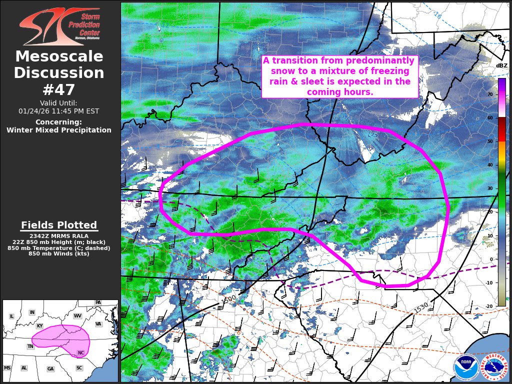
How uncertain is the NWS about snowfall rates for the next few days?
This uncertain.

"<11 inches" and "anywhere from 1 to 15"
So it’s basically “there’s gonna be snow, so prep I guess”
NWS has more updated guidance:
https://abc7chicago.com/post/chicago-weather-snow-possible-sunday-monday-winter-storm-watch-warning-advisory-cook-will-porter-lake/18133390/
Pink area could see a foot of snow in 24 hours.

ABC7 Chicago
ABC7 meteorologists have issued an AccuWeather Alert for Monday, as the possible snowfall could create dangerous travel conditions during the morning commute. Rounds of snowfall were expected to start late Saturday.
The Chicago National Weather Service (NWS) issued a significant statement regarding an intense lake effect snow event. In over a decade, this is the strongest wording I have seen from them. It's rare for us to experience a north or northwest flow that results in lake effect snow

Important note that this was Accuweather, not the NWS,
A good chunk of the community do not respect them to put it lightly, lobbying and other political stuff (and the fact they would profit from the privatization of meteorology, long story.)
(Honestly- it is kindof scummy they'll gladly sell you $60-$120 subscriptions using data they get from the NWS for $0
Pelo menos 8 tornados foram identificados em SC e PR na última sexta-feira. O tornado mais significativo, que atingiu Rio Bonito do Iguaçu, recebeu classificação *preliminar* de F4 no nosso banco de dados com base nos danos na cidade. Vamos atualizar os dados nos próximos dias.

Prelim of F4 👀
(Brazil does not use the EF nor the IF scale.)
It's always so weird to hear about other countries' tornados. They seem to be a lot less common than the US. It's that true or is that just my Americanized view?
They're certainly less common, but still somewhat frequent, China's a great example, receiving an est 100 or so a year. (USA usually records around 1,200 a year)
Europe in general get around 100-200 a year, most of which occur around Germany/France/Austria/Poland
Australia gets around 50-100,
The USA has the exact right conditions for it to be more "widespread", but here's South America's "Pasillo de los Tornados" ("Tornado Corridor") in red.
I'd estimate they get somewhere around the 100-200 rate a year (Still a very developing field in meteorology, very little tornadic data from this part of the world), but these are known to be decently strong sometimes- and is frequently called the "2nd most active" spot on the Earth for tornadoes.

How very interesting!
SNOWSPOUT OFF OF LAKE MICHIGAN EAST OF CHICAGO @NWSChicago


▶ Play video
 FxTwitter
·
FxTwitter
·
Reports of 30 people injured at a campground in Portugal after a tornado tracked through the area.
Radar data shows a hook shaped core when the tornado happened, this could be the cause of this disaster.

Wonderful piece of storytelling from @nytimes. I am still SO ANGRY about this tragedy. It was a floodplain with HISTORY. The incompetence of the leadership at this camp cannot be overstated. Unavoidable tragedies do happen.. This was not one of them. https://t.co/ra3aFvOPfX
I will note that a small subsect of the weather community shares the same reasoning (me included), the management at the camp were horrifically negligent.
(For example, they should have had a weather radio, especially being a campground for children, you can buy a decent one for about $50.)
even if you believed flooding was never an issue.... SEVERE WEATHER IN GENERAL WOULD BE- This area is on the edge of one of the most active tornado-producing areas in the world! (Corridor from San Antonio onwards is what you start thinking about when you think about a "TX/Dixie type tornado" (Panhandle is more Plains-esque,), and typically sees comically large hailstones! (3+ inches)
The Dixie sorta-type of tornado is a pure blob of rain (usually at night) that conceals your tornado almost entirely from an outsider's perspective.
The Plains sorta-type is your photogenic, low rain/high visibility types (usually at day.)
They either didn't- or didn't listen to it.
(internal discussion from me about this topic on July 17th, 13 days after the incident.)

Sorry about the mini rant but this led to 27 deaths out of the county's 117. (23%.)


In reviewing the data- a 252 MPH wind gust was recorded from Hurricane Melissa.
..I believe it's the 2nd highest wind gust recorded in human history [non-tornadic*], (1st being from Cyclone Olivia, 254 MPH)
(Estimated fastest ever windspeed that was recorded is an estimate of 281-321 MPH from the 1999 Bridge Creek-Moore F5)
(An additional calculation in the 2013 El Reno tornado also suggests **that **tornado had subvorts which potentially had 257-336 MPH winds)
(This is more debatable as the peak windspeed could have been < 3 seconds, which technically wouldn't quite qualify it as a standard wind gust reading)


Fairly light damage reported so far, trees down+ roof damage (One unlucky home owner also had both happen to them when their tree went through their roof)
Got my eyes on this cell just north of Mongomery, AL

...could show some potential in a bit,


... This scrawny one to the NE might actually beat it to the punch at this rate, I actually had ruled it out initially, but well, decided to get it's act together

... Might have produced an extremely brief and weak tornado. (If it was active, wasn't by the next scan, 3 minutes later.)

(Also might be a "leafnado", an extremely weak one that only really popped up on radar due to an abundance of "loose debris" in the environment, eg- dead leaves.)
two tornadoes documented for the Houston area yesterday, Cyprus EF1 (Prelim of 105 MPH) and the Louetta EF2 (115 MPH)


Relation to downtown Houston

Canada is altering their weather alert scales:
https://www.cbc.ca/news/canada/nova-scotia/eccc-weather-warning-system-changes-9.6991783
Environment and Climate Change Canada has changed its weather warning system across the country.
General watches and warnings are being replaced with a colour-coded, risk-tiered system so you have a better idea how the forecast will impact you and how you should prepare.
The changes align with recommendations from the World Meteorological Association and follow updates already implemented by 31 weather agencies across Europe.
Notable quake, right next to Anchorage, AK

hey everyone, im a geologist, so i felt compelled to check out this channel for obvious reasons
Welcome!
Klein TX EF2 upgraded slightly to 125 MPH (was 115 MPH)

Today marks Day 8 of nonstop Tule Fog across California’s Central Valley, and it may be at its greatest extent yet.
A sea of fog stretches from Lake Shasta all the way down to the Grapevine, nearly 450 miles long and has now spilled into the Bay Area.


Sacramento, California hasn't been above 47°F in over 110 hours.
Brutal stretch of Tule Fog continues.

Thought this might of interest here:
When a magnitude 8.8 earthquake ripped through the Kuril-Kamchatka subduction zone on July 29, 2025, it launched a Pacific-wide tsunami – and a rare natural experiment.
NASA and the French space agency’s SWOT satellite happened to pass overhead. The satellite captured the first high-resolution, spaceborne swath of a great subduction-zone tsunami.
https://www.earth.com/news/satellite-captures-the-first-detailed-look-at-a-giant-tsunami/
Abstract (with link to PDF)
https://pubs.geoscienceworld.org/ssa/tsr/article/5/4/341/718867/SWOT-Satellite-Altimetry-Observations-and-Source

Earth.com
A rare SWOT pass mapped a Pacific tsunami in detail, exposing hidden wave complexity and showing why forecasting models need a major update.
Nevada just had a pretty big false alarm go off in terms of earthquakes, incorrect M6.0 warning issued
Who else got that ShakeAlert? 🙋♂️ A supposed magnitude 5.9 earthquake centered near Carson City, Nevada triggered the alerts for most of Northern California!
And now the event has been deleted from the USGS website. 🤔
#CAwx @ABC10

I read a few raspberry pis also picked it up. Wonder what it was

(My initial theory of it being a bunch of smaller earthquakes around sensors also was erroneous btw, One station auto chucked a M3.0 estimation over.... nothing)
(So that's a lil confusing)

Mostly in the middle of nowhere, although i'd like to hear updates from the comically small area of Yakutat, Alaska
(Likely fine, but they probably got rocked a bit)
AK/CAN Earthquake update (since a few hours have passed)
USGS has assessed it as a M7.0 currently,
aftershocks so far are in the M3-M4 range as expected (Although a M5.0 and M5.1 were recorded)
(In the cluster around the red dot- the other ones to the side were much older ones)

Personally- doesn't seem like the M7.0 was a foreshock, based on this data coming in so far,
(Although the science behind trying to figure out what is and isn't a foreshock is still... debatable, but erring on the side of "nothing ever happens" with this one)
aftershock estimations for this specific earthquake,

Fun additional facts, an estimated 100 to 1,000 people felt this to any notable degree, initial reports are suggesting the much lower end of that range.
(Currently 0 reports of notable shaking due to how rural the area was)
Again- haven't heard squat from Yakutat, but again- they're likely fine and possibly the only people who notably felt this to any degree.
(Upwards to like VII on the Modified Mercalli Intensity scale if i had to guess, but was likely much lower, potentially to the III-IV range.)
This is one of those events where we get a pass to nerd out about it because absolutely no one got hurt/ inconvenienced from what we can tell currently
(And oddly, like the 2nd/3rd of a intense major** one doin that this year.)
[Edit-** brain flipped to using tornado terminology, oops.]
Notable aftershock (Same reasoning as above, likely very few people felt this, but in hindsight, this entire ridge has been quite active this year, slowly expanding it's range)

If that trend continues, i wouldn't be too shocked to see some light quakes start kickin up closer to Vancouver along the same fault line.
(Likely wouldn't be all that strong-)
BREAKING: 7.2-magnitude earthquake hits off northern Japan, tsunami advisory issued - JMA

Well, I was asleep for this one.
"Hokkaido-Sanriku Megaquake advisory issued"- an internal source I have via an earthquake fourm, absolutely trying to get some official verification, (in english)
🚨 The Japan Meteorological Agency is currently reviewing whether to issue the “Hokkaido–Sanriku Offshore Subsequent Earthquake Advisory,” which would mean the likelihood of a megaquake in Northern Japan is higher than normal, with this quake possibly acting as a precursor.


Every Hour. Every Day. Live News from Japan, Asia and the World.
Latest News On Demand:
https://www3.nhk.or.jp/nhkworld/en/news/programs/?cid=wohk-yt-org_site_newslive-202203-001
Top Stories:
https://www3.nhk.or.jp/nhkworld/en/news/?cid=wohk-yt-org_site_newslive-202203-001
For More Quality Programs:
https://www3.nhk.or.jp/nhkworld/en/ondemand...
Weird having people you know IRL be close enough to actually experience it
Highest recorded tsunami height as of now, 0.5m (50cm/ 19 inches)
(Per https://www.jma.go.jp/bosai/map.html#8/41.276/142.443/&elem=warn&contents=tsunami&lang=en)

Technically my "boss" felt this one lol
(Freelance research stuff for YT)
two coworkers for me
We're getting another 100 year flood in the PNW
https://bsky.app/profile/cascadiadaily.com/post/3m7nn7fzp422f

-# ↩ Cascadia Daily News (@cascadiadaily.com)
Large debris, root balls and logs moving quickly down under the last bridges before the North Fork joins the Nooksack. Video from @simonelli.bsky.social.
Live updates are outside our paywall. Click the link above to read more.
shttps://fxtwitter.com/brianemfinger/status/1999129544633029006


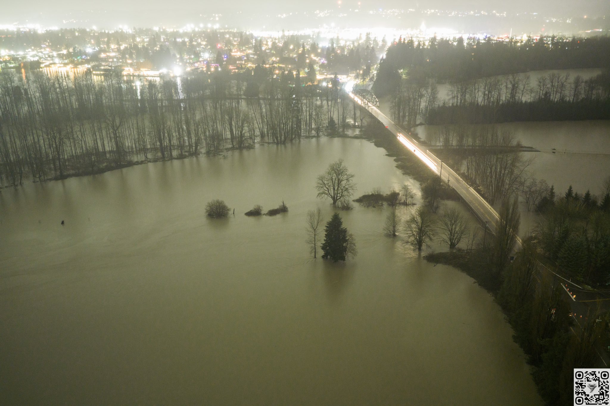

Are there any pics of Concrete, WA that youve seen? Skagit county ordered an evacuation of around 75k people yesterday. I think the Skagit River is going to crest at 46 ft in concrete and 42 in Mt Vernon last I checked
I drove through some of it yesterday around noon and it was starting to get bad
Haven't seen anything, sorry, Twitter's been fairly quiet for that area too,
Makes sense. I imagine most evacuated. A friend of mines family lives in Mt Vernon. They had to evacuate
Cascadia Daily News has all their flood coverage outside of their paywall as well

Skagit County remains under evacuation Thursday morning as the Skagit River is expected to crest in Concrete around 10 a.m. The Nooksack River at North Cedarville hit its crest overnight but flood waters remain in Everson. Check back for live updates throughout the day.
-# Thursday update: Skagit County under evacuation; Nooksack River at Cedarville crests | Cascadia Daily News
Most rivers in Whatcom and Skagit County will be in major flood stages throughout the day
Strong quake near Japan, prelim of M7.0
(Edit- downgraded to M6.5 roughly)

Absolutely EPIC meteor shower viewing TONIGHT (Saturday night) worldwide (weather permitting) as the Geminid meteor shower peaks! GREEN fireballs will streak across the sky, with 50+ visible every hour to observers under ideal conditions (even factoring in human field of view, etc.)
︀︀
︀︀The slender crescent moon won’t rise until about 1 a.m. local time, meaning there’s nothing really to outshine the fainter meteors.
︀︀
︀︀How can you enjoy them? Simply find a clear, dark location. Avoid city lights and turn off your phone screens to allow your eyes to adjust to the darkness. (No telescopes or binoculars needed!)
︀︀
︀︀And there's no specific time! As long as it's dark. 9 PM to 1 AM will probably be best before the tiny crescent moon rises.
︀︀
︀︀Each individual meteor is actually only the size of a grain of puffed rice. But they're entering Earth's atmosphere at 22 miles per second, generating enormous frictional heat. So t…


I'll admit I don't know where to start to factcheck this one. Any idea if this is based on some modeling or is it pure scaremongering?
https://bsky.app/profile/weatherprof.bsky.social/post/3m7wcbhh63224

Pineapple Express will deliver a barrage of tropical fire hoses directed at the US West Coast over the next two weeks. Pockets of 12-18” of rain and flash flooding. The first round hits the Seattle Area early this week, as rivers are already at historic levels. Be ready to take immediate action.
...Yes, this is a direct pull from ECMWF (as seen in the top left),
This is specifically the 12Z (Zulu) run that was initialized on December 13th, 2025, valid for the given time period (top right)
(If i were to guess, this was pulled from pivotal weather, https://home.pivotalweather.com/)
Excessive rainfall outlook for the 14th, 15th, 16th,


Also of note- the NWS forecast discussion, as per https://www.wpc.ncep.noaa.gov/discussions/hpcdiscussions.php?disc=qpferd

Jeff Berardelli is also a degreed meteorologist out of Tampa FL, specifically for WFLA-TV, and used to be the meteorologist for CBS NY.
As an aside for general "non-thunderstorm specific" type weather,
the Weather Prediction Center will prolly be your best bet (WPC and the SPC are two different "branches" of NOAA)
(In total, there's the AWC- Aviation Weather Center, CPC- Climate Prediction Center, EMC- Enviromental Modeling Center, NCO-(you don't really need to care about this one, internal stuff), NHC- National Hurricane Center, OPC- Ocean Prediction Center [general boat stuff mainly goes here], SPC- Storm Prediction Center, SWPC- Space Weather Prediction Center, and finally, the WPC- Weather Prediction Center)
all of these are under the NOAA
AWC- https://aviationweather.gov/
CPC- https://cpc.ncep.noaa.gov/
EMC- https://emc.ncep.noaa.gov/emc.php (This is primarily just research papers tbh about the weather models the others use)
NHC- https://www.nhc.noaa.gov/
OPC- https://ocean.weather.gov/
SPC- https://www.spc.noaa.gov/
SWPC- https://www.swpc.noaa.gov/
WPC- https://www.wpc.ncep.noaa.gov/
Confused yet? I haven't even gotten to the more niche subsites some of these use, such as water.noaa.gov (https://water.noaa.gov/) which tracks only flood gauges.
If it's weather/ nature related in some sort- odds are the government has either a branch covering it or a specific site for it)
(There's probably a lot of these i don't even know about)

The Seattle Times
The swollen Green River tore a hole Monday in a heavily saturated levee system near Tukwila, forcing broad evacuations and emergency repairs.

For over three straight weeks, California's Central Valley has been entrenched in a seemingly never-ending fog. While this kind of fog is not uncommon in the Central Valley, an event of this duration is quite unusual. In this video, we break down the meteorology behind this fog event, including what causes it, why it's been so persistent, and if...
3+ weeks of significant fog for central Cali
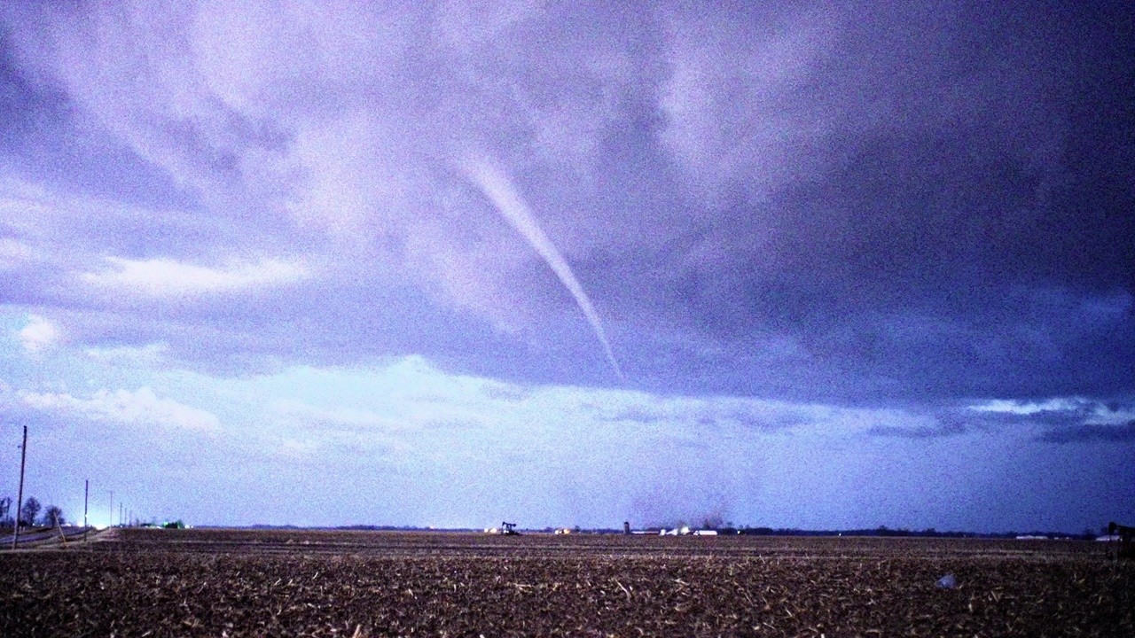
First tornado watch in a bit,


Good ol QLCS setup up top, producin a bit of spin in SW Kentucky,

down in this area the line gets a lot more broken up, which is of note, as that wasn't quite what the initial forecast for today had, (these are somewhat discrete supercells instead of being blobby messes.)


how powerful is that compared to the scale USA uses…? Hold on I’ll google
Ok fuck that’s powerful
IF is focused around European (usually) tornadoes,

Here's the PDF document from ESSL going into the IF scale
Some contries use a modified version of the IF scale too it gets messy
the underlying purpose is that it's relative to construction (styles, building type, and construction quality in general), atleast the EF scale is
But overall, IF5 ≈ EF5 according to my googling
If you're sheltering in an average house, built to code, you should reliably survive anything under EF4, (key word is should.)
Once you start getting past that range it starts becoming pure luck, as you'll start to see significant debris intrusion/ structure failure.
My common shorthand is "if there's a room you could have rode it out in- (eg- a bathroom/closet), prolly around DOD8, Once you start seeing everything collapse into a pile... DOD9, if the pile is down the block, DOD10.
(As long as it is a decently constructed building and is secured to it's foundation, else that'd be like, DOD5.)

i do like how they've subdivided everything into what we'd just shorthand as the vague "Upper end/ Low end", but they only do this for the lower end of their scale

like if you hear someone say "Upper end EF3", that could be like... anywhere from like 145 or 150 MPH to the limit of the rating itself (165 MPH) tbh, It's really messy,
(By the way, i'm trying to get into the practice of rounding all of the windspeed estimates to the nearest 5 MPH to align with the new EF scale revision that's been in the works since like 2010, still waiting for that to get public.)
How will storm chasers remember 2025? This documentary film follows my entire 2025 storm chase season—from early struggles and missed opportunities to violent, deadly tornadoes and unforgettable intercepts across Texas, Oklahoma, New Mexico, Missouri, and beyond.
In recent years, many chasers remember 2018 and 2020 as lackluster seasons—ye...
New Pecos Hank vid reviewing his year, would recommend.


Tornado in Illinois
...ight be surprisingly strong- little rare to see that spiraling signal in your CC (bottom half of both screenshots)


(suggests a lot of debris, and a good chunk was lofted quite high)

We are live right now tracking a significant tornado on the ground in Illinois. This storm is producing major damage and lofting debris 15,000 feet into the air. Do not wait to take shelter if you are in the path. Tune into the live stream immediately for coverage. www.youtube.com/watch?v=ErWPNZ1IsDc


What seems like another brief strong one up north, near St. Anne, IL

Tornado damage in Mount Zion, Illinois. Search and Rescue still underway in some homes.
︀︀@NWSLincolnIL @MyRadarWX @ryanhallyall
︀︀#ilwx #tornado


swarm of somewhat notable quakes in northern Canada+ Alaska.
Good couple in the M5-6 range in a quick period
Seems to have calmed down- atleast one of these is legit (Prelim M5.7), still checking to see if all of them are, (Would be a total of 5 of M5+ w/in 20 minutes if so,)
(Again- much better to get the energy out in these swarms over a long period instead of one big quake)
Sorry i've been real quiet on the tornado side of things, working on revamping an old metric for rating tornado outbreaks.. still putting it through the wringer!

(For example- under the current OIS system, the most notable tornado outbreak since 1/1/2020 would have been** March 13–16, 2025**(https://en.wikipedia.org/wiki/Tornado_outbreak_of_March_13–16,_2025)- 118 tornadoes, ||MOIS-210, OIS-147||
(Under my current modification, it points at May 19–27, 2024, (https://en.wikipedia.org/wiki/Tornado_outbreak_sequence_of_May_19–27,_2024)- 248 tornadoes ||MOIS-267.1, OIS-112||
A short explainer.
The current OIS scale only looks at tornadoes rated EF2+ of a given outbreak, (EF2- 2 points, EF3-5 points, EF4-10 points, EF5-15 points)
my modification just includes the lower end, (EFU-0.1 point, EF0-0.5 point, EF1-1 point), which should account for events where more- but weaker- tornadoes occur, doing more damage in theory to a larger area.
working with this, you can then start doing "cursed metrics" like "MOIS/TOR", which... in theory could derive the average intensity of any given tornado out of a given outbreak (you have to look at the points given to each category) only 2 events have come close to having their M/T hit the "EF2 bucket" of 2, and obviously, none are close to the EF3 bucket (of 5 points) as an average. Most are solidly in the 1-2 range, although there are notable events as far down as 0.59![Just above the EF0 bucket of 0.5!].
I'm hoping to work out a MOIS/HOUR system, but i will need to get quite in the weeds for that, hoping to be as precise as possible using radar archives.
Is this a little unhinged? Sure, but i'm hoping some level of pattern can be found if i expand this dataset (theoretically to the 1880's! Would need to get some historians if I go that far)
Notable earthquake, Mexico
Prelim of M6+
Edit- USGS gives it a M6.5, https://earthquake.usgs.gov/earthquakes/eventpage/us7000rm3k/executive

So far not seeing anything too concerning in terms of damage/reports (or at all,) lotta people mentioning being woken up by it, (primarily checking posts on Twitter/ FB.)
Probably will be a relatively minor news story (Not ruling out very light damage as of now closer to the epicenter,) , but certainly a way to wake up from a nap.
Reports of trees/utility polls down and video of buildings shaking in Mexico City per La Jornada and La Reforma. At least one fire is seen in the videos.

La Jornada
La mañana de este viernes 2 de enero de 2026 se registró un sismo de magnitud 6.5 de magnitud en la Ciudad de México, con epicentro al suroeste de San Marcos, Guerrero.
On 1/1/26 at ~1:05 PM, the first tornado (landspout) of the year nationally occurred near Three Points.
This occurred over open desert w/ no known damage. The pics show a funnel w/ a faint surface reflection. #azwx
📸Eric Allan/Washington Weather Chasers

First tornado of 2026 occured in Arizona, doing no damage 🥳
Looking at a potential severe weather event (Maybe) Thursday, (Likely) Friday, and (maybe) Saturday.


Strong quake, southern Japan, prelim of M6+

I have to use JQuake for this one as my program doesn't have a lot of stations for that area.


I personally wouldn't expect to see too many strong tornadoes (if any) off a setup like this, but they might be moving quite quickly (45-60 MPH forward speed roughly)
... Primarily a straight line wind threat imo.

Not really an update to this as we get closer to the event, will forward the discussion though, 5% TOR, 15%WIND, 5% HAIL risks,
Biggest conclusion is that the models are not exactly agreeing and confidence in any more exact forecast is.... limited.

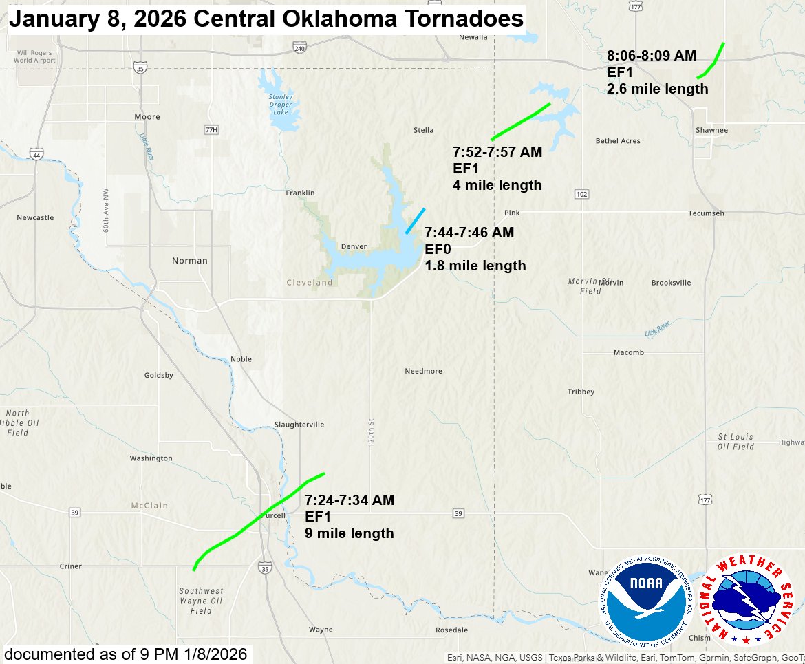
Tornado crossed I 35 near Purcell. Semi flipped (driver ok) and I can see some minor damage in town. #okwx @NWSNorman

Tornado spam today in Oklahoma
Four tornadoes have been documented so far from this morning's storms across central Oklahoma. EF1 tornadoes struck Purcell, Shawnee and near Shawnee Twin Lakes, and an EF0 tornado occurred near Lake Thunderbird. Investigation continues in these and other areas of damage. #okwx

First tornado for today (imo the models have really not impressed me on this, looks to be a pure blobfest of a day again)
Tornado likely went active roughly around :25, likely stopped doing damage at :32 or :36 and you start seeing (very light) debris fallout.


^Likely had one brief tornado NE of Auburn
@unborn timber Godspeed for us Texans. The power grid gonna implode on us

... Yeah I'm gearing up to take the brunt of it
Last "big snowstorm" we had up here in the Appalachians, we lost electricity for over 2 weeks, caused a genuine crisis around here back then.
Godspeed over there
Dang I’ll have to visit my local Walmart to pick up a tool to scrape ice from my car
After work though
Y'all FEMA is not ready for a winter storm that needs the hurricane hunters deployed
Recon (aka the hurricane hunters) now have flights planned to help improve model guidance for the upcoming winter storm.

Yikes! We've got some stuff moving into SW SK tonight 90-100 kph winds, but nothing that will take us out for 2 weeks!
The worst I've experienced in 60 years is a 3-day outage that threatened to go much longer. At breakfast on the 3rd day, they didn't even have an ETA on arrival in our area, let alone on restoration of power. I started rationing the propane for our standby generator (tough at -30C) to give us 2 weeks (1 week is possible at 100% duty cycle). By bedtime, power was back.
This seems to be a pure scientific expedition,
I don't recall them doing this prior, but the data they grab would certainly be useful for improving forecasting going forwards.

Guidance for the Major Winter Storm shifted north a little overnight, further expanding the areas forecast to be impacted Friday through this weekend. Here are the latest Key Messages.

I am a Psychology and Computer Science student
Hi! I think you may have clicked on the wrong channel. We have a special channel for #introductions .


Starting to get mooore concerning wording now from some more local offices

All I'm going to be doing Sunday is shoveling snow
Watch out for wind chill btw as we get out of this!
My area might end up feeling closer like -12F on Tuesday


Over 144 million people are now under Winter Storm Warnings. This high-impact winter storm is forecast to bring widespread heavy snow and catastrophic ice accumulations from the southern Plains/Rockies to New England through the weekend. Please follow advice from local officials.


watch ERCOT instantly light up red I’ll be watching too
yes I’ll take every opportunity to shit on ERCOT
TX at 14k
US National Weather Center advising flash flood potential in portions of central Texas and the Hill Country as well as near Houston
#WPC_MD 0015 affecting portions of central Texas and the Hill Country, #txwx, https://www.wpc.ncep.noaa.gov/metwatch/metwatch_mpd_multi.php?md=0015&yr=2026


Power outages as of now

There's your ice band, suprisingly straight line of outages so far if you organize by county.
Remember everyone, it's much easier to shovel snow every few hours than waiting for the whole thing to be over
Depends how long you're prepared to wait? 😉
I have this whole routine where I hang my coat on the heating vent so it's super toasty and it sounds so nice outside when it's snowing
yaaay
🫠
..also- might have some tornadoes tomorrow in southern AL

Don't forget to open the door and let the Roomba go play in the snow.
Texas weather go brrrrrt

I’m not letting Clinton The Claymore Roomba outside! He’s a good boy who deserves a good inside of a house
But they get to clean so hard. It's their dream.
…who said mine cleans?
@plain blaze that's called deposition, when a gas turns directly into a solid
yes it goes by both terms, but I was using a double entendre as it also has critical theory meaning. https://www.sciencedirect.com/science/article/abs/pii/S0017931020330106
Interesting, I had never heard it called that before
New York winter storm update: Gov. Hochul restricts travel, deploys National Guard
Note on this, snow shoveling can increase risks of heart attacks due to sudden exertion:
https://newsroom.heart.org/news/snow-shoveling-can-be-hazardous-to-your-heart
American Heart Association
DALLAS, Dec. 15, 2022 — Clearing sidewalks and driveways of snow may be essential to keep from being shut in, however, the American Heart Association, the world’s leading nonprofit organization focused on heart and brain health for all, urges caution ...
Yep! Less strain with frequent shoveling is safer I think
Ja be careful, how's the Roomba
It's so happy, just like the time I took it to the beach and let it clean all the sand

Over half a million reportedly w/out power currently


This video shows the evolution of the last 24 hours of power outages with the ongoing ice storm. As of 7:00 AM EST Jan 25, there are close to 600K customers without power and climbing.


Nearing 1 million power outages

90% of Davidson is out- (TN county holding Nashville)
97% of Hickman (also in TN)

Brief tornado NW of De Funiak Springs, FL


The dogs are having the best time
NPR
Reporters from across the NPR Network are covering the storm in each state — the impact and how officials are responding.


Just had my first tree "explosion",
right outside my window, real loud pop, can confirm, sounds exactly like a muffled shotgun blast.
It gets to -15 (C) today,
... Lotta trees fell last night from the icing, going out to take pics

https://www.spc.noaa.gov/climo/dataviewer New very cool tool dropped today
I can now pull historical graphs like this!


BREAKING: SPC outlooks are getting a makeover this spring! New conditional intensity graphics will show more detailed breakdowns of tornado, hail & wind strength probabilities.

(Will say, a little visually confusing at first glance, even after having many months to poke at this)


Big changes are coming to Storm Prediction Center Convective Outlooks on or around March 2!
︀︀
︀︀-Introduction of three different types of hatching for significant severe weather, corresponding to increasing intensity of potential hazards
︀︀
︀︀-Addition of 75 and 90% wind contours
︀︀
︀︀Read more about the upcoming changes here: www.spc.noaa.gov/exper/conditional-intensity-information/
︀︀
︀︀What are your thoughts? Might get to work on a video discussing these changes in detail and how to interpret them.

The old 10% Significant hazard outline is being replaced by three intensity levels (two for hail). These thresholds are not tied to a probability. They are our best estimate of what the maximum hazard intensity could be based on expected storm mode and environmental parameters.

(We are in the "inbetween" periods of standard severe weather coverage, but- more time to look at cool data like this)
Notable quake, Myanmar. (very iffy on magnitude here, very few stations)

Sahara dust enhancement in cloud tops from 04.02. 2026 8:00 UTC, HRV and day snow fog MTG products https://view.eumetsat.int/productviewer


Enjoy this absolutely stunning alluvial fan in Albania which I found while working on leech list https://www.google.com/maps/@42.2337996,19.4558059,14013m/data=!3m1!1e3?entry=ttu&g_ep=EgoyMDI2MDIwNC4wIKXMDSoKLDEwMDc5MjA3MUgBUAM%3D


Ice on Lake Erie broke up today, several better animations out there I think though... Right above Cleveland


Little bit of a tornado threat today, looking at afternoon -> overnight

... Imo, if anything really tries to get strong it'll probably be closer to the MS river (Tylertown area?)
Today is primarily a straight-line wind and a minor hail threat.

QLCS tornado spam in Louisiana currently.

..wow, KPOE got a few good scans of a few very brief spinups.


https://www.youtube.com/watch?v=UDAZWxehMAI 4K live view of Mayon Volcano, one of the world’s most active and iconic stratovolcanoes, currently exhibiting heightened volcanic activity.
This 24/7 ultra-high-definition (4K) livestream provides a continuous real-time view of Mayon’s summit and upper slopes during an active phase marked by lava dome growth, frequent rockfalls, and occasional pyroclastic density currents (PDCs).
On January 6, 2026, the DOST-PHIVOLCS raised Mayon’s status to Alert Level 3, indicating an increased tendency toward a hazardous eruption. Monitoring data confirm ongoing effusive magmatic eruption, with slow but accelerating extrusion of degassed magma at the summit dome. Dome instability has led to hundreds of rockfall events, some displaying nighttime incandescence, and PDCs affecting gullies on the volcano’s southeastern flank.
This livestream is intended for public awareness, education, and scientific interest. It allows viewers to observe real-time changes in volcanic behavior, including dome collapse events, glowing rockfalls at night, ash emissions, and evolving weather conditions around the volcano.
⚠️ Safety Notice
A 6-km Permanent Danger Zone (PDZ) remains in effect. Entry into this zone is strongly discouraged due to the risk of rockfalls, lava flows, PDCs (uson), ashfall, and other volcanic hazards. Aviation authorities advise pilots to avoid airspace near the summit.
All interpretations of activity should rely on official advisories from PHIVOLCS and local authorities. More info: https://www.phivolcs.dost.gov.ph/
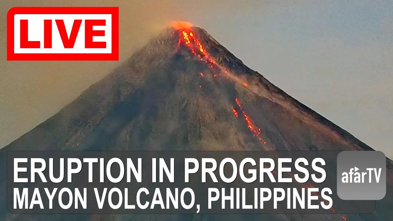
4K live view of Mayon Volcano, one of the world’s most active and iconic stratovolcanoes, currently exhibiting heightened volcanic activity.
This 24/7 ultra-high-definition (4K) livestream provides a continuous real-time view of Mayon’s summit and upper slopes during an active phase marked by lava dome growth, frequent rockfalls, and occasi...
I think this might be the most relevant spot to put this here but looks like an interesting conversation has been taking place
https://bsky.app/profile/armscontrolwonk.bsky.social/post/3meyp4e4jsc2p
I wonder if this event is the alleged China nuclear test: 22 June 2020/0 depth/41.27, 90.75/~150 km from the test site, just outside error ellipse. The P/S amplitude ratio might show if it was an explosion--need a real seismologist for that. kndc.kz/index.php/en...


related
https://bsky.app/profile/gbrumfiel.bsky.social/post/3mf2uwdii4c2k
https://bsky.app/profile/gbrumfiel.bsky.social/post/3mf2v5w3nyc2k
https://bsky.app/profile/jonatomic.bsky.social/post/3mf2xmeegik2q
BREAKING: Assistant Secretary of State for Arms Control and Nonproliferation Christopher Yeaw has revealed new seismic data that hinted the Chinese had conducted a nuclear test and taken steps to hide it from the outside world.
This is the event:
0918 Zulu/Kazakhstan PS23/around 2.7 magnitude

-# ↩ Geoff Brumfiel (@gbrumfiel.bsky.social)
Remarks are being made here:
www.hudson.org/events/assis...
-# Assistant Secretary of State Christopher Yeaw on the End of the New START Treaty
-# ↩ Geoff Brumfiel (@gbrumfiel.bsky.social)
Not verified until @armscontrolwonk.bsky.social tells us so
Independent experts did not immediately agree with that assessment. The ratios of different seismic waves is consistent with an explosion, said Ben Dando, the head of seismology and verification at NORSAR, a Norwegian organization that watches for possible nuclear tests. But, he added, the signal was weak, and it was recorded at a single station. Based on those limitations and others, he believes that it's still possible that this could have been a natural event.
"I would not say that there's really strong conclusive evidence," Dando told NPR. "We can't really confirm or deny whether a nuclear test took place at this point."

NPR
At a event in Washington D.C., A U.S. official said a remote earthquake in 2020 was caused by a Chinese nuclear test.

TERRIFYING WILD FIRE ongoing right now north of Hooker, OK! Be ready to EVACUATE @ryanhallyall @WxWiseApp
(Current fire-condition outlook)


KAKE
A dangerous wildfire environment is expected as wind gusts will be on the increase throughout the day and the relative humidity will be falling.

HUGE FLAMES are targeting livestock north of Hooker, Oklahoma currently. This is horrible… @ryanhallyall @WxWiseApp
a surprisingly vicious fire kicking up in the OK Panhandle


OMG. Absolutely terrifying pyro plume on the wild fire southeast of Tyrone, Oklahoma currently. Firenadoes ripping on the leading edge…
(0:30-ish for the pyrogenetic tornadoes along the edge there)
Stuff like this makes me twitch. I'm a retired volunteer firefighter in grassland/cropland country. I hate prairie fires so so much. From "let me grab a shovel" to "holy shit!" in the time it takes to get said shovel.
While I was still active, nearly 100% of all wildland fire training was on forest fires. Prairie fires are a completely different beast and most of what we claim to know of their behavior seems to be a kind of hand-me-down knowledge as opposed to derived from formal study.
Wind gusts for the area are consistently being reported in the mid/high 50's to low 60's (MPH)
FIRE WHIRL intercepted west of Englewood, Kansas as fast-moving wildfire is threatening the town. Firefighters battling the fire on the north side of town! WATCH: https://t.co/0Ex1dUESea

A different wildfire is causing quite the massive evacuation of Woodward, OK. (Population of ~11,000)
Warning specifically notes the southern half of the city currently.


Extreme Fire Threat in the Southern Plains - Oklahoma, Kansas and Texas
Download the BEST radar app, Radar Omega, today and watch me and several other storm chasers within the app! iOS: https://bit.ly/maxarcheriOS Android: https://bit.ly/maxarcherandroid #ad
Use this link to follow me on other social media platforms! https://linktr.ee/maxarc...
Chaser in Woodward, OK reporting the fire's jumped 22nd ST.

HEARTBREAKING First Light of the Ranger Road Fire aftermath across Beaver County, Oklahoma, this morning. The Ranger Road Fire has burned approximately 145,000 acres, injured four firefighters, and destroyed a few homes. Please keep everyone impacted by yesterday’s fires in your thoughts and prayers 🙏
So, bit of a tornado threat today for parts of the Midwest/ Ohio Valley

The MD notes that some decently strong tornadoes could occur, but imo this is the type of setup that if anything strays from ideal conditions, you won't see anything (High ceiling, extremely low floor type risk)


Tornado Warning including Robinson IL, Palestine IL and Flat Rock IL until 5:15 PM CST


Unfortunate news coming out of Crawford County. Authorities have confirmed at least two houses were destroyed by the tornado earlier this afternoon.
︀︀
︀︀Looking at the home in this image, the damage is devastating, it’s clear why the NWS issued this with a PDS (Particularly Dangerous Situation) tag.
︀︀
︀︀#ilwx #Tornado #CrawfordCounty #Illinois
︀︀
︀︀www.facebook.com/share/p/17JrVR91Xp/?mibextid=wwXIfr
**❤️ 1 👁️ 5 **


From initial damage reports (from the general public), Damage is quite minor to Bloomington itself, luckily.
I was able to geolocate this to (38.911662542737545, -87.75957796881993) thanks to this vid- https://www.facebook.com/reel/1575586390597517
Does help with figuring out where everything was specifically moved from (eg- that red shed on it's side)
(I have passed this on to the local NWS office in that area so they can survey this area if they were not able to (due to a lack of info on where this was in the first place.)


Bloomington tornado given an EF2 prelim (120 MPH), May change [in either direction] as damage surveys continue
Could have been real bad if this storm produced a tornado 10-20 minutes later instead.

Meanwhile NYC is not having a fun time with this snow system


JUST IN: Providence, Rhode Island has officially measured their most extreme snowstorm in recorded history, with 32.8 in of snowfall and climbing.
︀︀
︀︀The previous record was 28.6 in, set during the Blizzard of 1978.
︀︀
︀︀Historic radar loop.

On March 3, 2026, Storm Prediction Center severe weather outlooks are changing! SPC is introducing Conditional Intensity Groups (CIG) to their Day 1-3 outlooks, which allow them to provide more specific information on the intensity of severe hazards that they weren't able to convey before. There have been a ton of questions and concerns about th...
Short updater about the forecast displaying change i've been talking about on and off recently
it's always tornado season in illinois! this is a quick cut of one of the tornadoes near Bible Grove, IL on 2-19-26. i'm fairly certain there was a cyclonic tornado from this storm immediately before this one, but i don't have good footage of it.
So far- best tornado footage i've seen of any of the tornadoes that day.
(And it's from Styropyro of all people.)
US Embassy in Peru issues weather alert (link)
The Government of Peru declared a State of Emergency (Level 4) due to heavy rainfall and landslides in the following regions in Peru: Amazonas, Áncash, Arequipa, Cajamarca, Ica, Junín, La Libertad, Lambayeque, Lima, Madre de Dios, Piura, Puno, San Martín, and Tumbes.
Peru’s weather service (SENAMHI) forecasts a short break in the heavy rains after February 27 but warns that intense rainfall may return between March 5-6. Peru’s El Niño monitoring commission (ENFEN) reports that the coastal El Niño weather pattern could continue through November 2026
Severe weather chances will increase by mid week and will continue into the second week of March. The highest confidence days for severe weather at this time are Wednesday, March 4 and Friday, March 6.

The further west you are, the more blood there will be in tomorrow’s blood moon lunar eclipse
www.timeanddate.com/eclipse/glob...
Likes
126

To be more clear, the dark red glow of the eclipsed moon in the Earth's shadow will be more pronounced according to this chart in North America.
The new outlook graphic (and next two severe days, starting w/ tomorrow.)


You may notice that new key in the bottom right, changes per specific risk category you pick


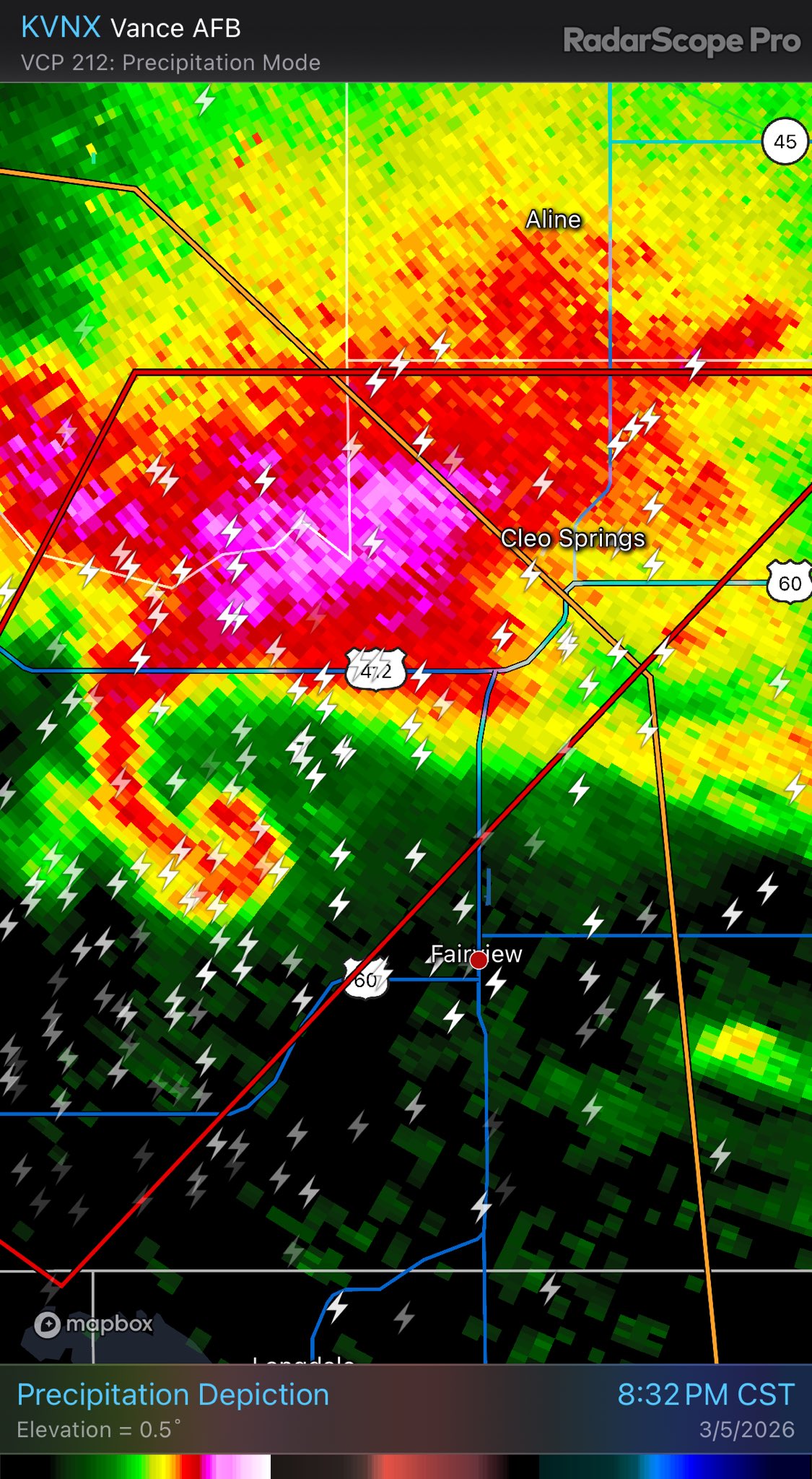

BREAKING: Large tornado moving towards Cleo Springs, Oklahoma

Likely missed Cleo Springs by ~1 mile or so. very close skim.


Southern Michigan*


... Likely a decently notable (and unexpected to a degree) tornado..

Look at how quick that spins up.
(Michigan?)
..yes, apologies, just got up from the alert.
still eepy brain, flipped part of the abbreviation apparently from MI to WI.
For context of why i was caught off guard- first likely strong tornado today occured in the red box.
Was not expecting a notable tornado for that area (hatched areas.)


▶ Play video
FxTwitter
·
So unfortunately there were 2 fatalities last night in NW Oklahoma from one of the more notable tornadoes, both from the same vehicle, prime example of the significant degree of damage these events can cause.

Fatalities not seen, but their vehicle (a sedan) is.
Agreed - the forecast map looks really rough for the bottom quarter of Wisconsin. Got really worried when I couldn't remember where Edwardsburg, Wisconsin was 🙂
And the main wave that i was waiting for is going to be starting soon™, probably next few hours for NE TX and eastern OK. (This watch will likely be expanded as the system continues.)

Meanwhile back in MI- a likely strong tornado is close (if not going into) Three Rivers, MI.


Footage just now coming from Lindsey Whitaker by Three rivers, MI.
︀︀
︀︀Big time PDS tornado causing damage
︀︀
︀︀#miwx #michigan #tornado
︀︀
︀︀www.facebook.com/share/r/1AYYGn8D7K/?mibextid=wwXIfr


🚨 PDS Tornado 🚨
︀︀
︀︀A confirmed large and extremely dangerous PDS TORNADO is on the ground near Three Rivers, MI. Debris is being lofted. Footage from Kainan Hix
︀︀
︀︀⚠️ LEONIDAS: You are next. Damage already reported in Mendon. TAKE COVER NOW! Basement or interior room.
︀︀
︀︀#miwx #tornado #michigan
(original source- https://www.facebook.com/reel/1477120963762962, rotated 90 degrees.)
Camera is at (41.934238, -85.650751)

Horizontal vortex reported. Likely very violent as this tracks into Union City, MI


VIOLENT TORNADO in Union City, MI!
︀︀
︀︀Horizontal vortices appeared several times!
︀︀
︀︀@MiStormChasers @NWSIWX
︀︀@ReedTimmerUSA
Please pray…multiple fatalities
We had a massive turnout of Samaritans helping everyone out as a community. It’s never easy to see this kind of destruction, but we dropped the chase and were able to help several people in the wreckage
Michigan strong ❤️
📍Union city, MI

Per a local resident- (Union City area.)

This one might be an issue in a looong term view, E of OKC.

Union City damage per https://www.facebook.com/share/p/1HVvJfHKJW/


Area affected. (42.057216, -85.184051)


Crossposting my thoughts from another server, the NWS doesn't usually have these pre-preliminary statements.

So the tornado is extra bad if they are saying all that. Fuck
very quick preliminary assessment of at least 150 MPH EF3 damage being noted for this tornado, assessments are still ongoing and are not expected to wrap up fully for atleast a few days.

Severe weather threat for Tuesday


The Union City, MI preliminary EF-3 tornado with max wind speeds of 160 mph is the earliest EF-3+ tornado on record in the calendar year for Michigan. It is also the strongest tornado to occur in Michigan since an F4 struck Kalamazoo and Eaton Counties on April 2, 1977.
For a minor scale of context of how weird this one was from a storm chasing perspective.
Union City damage itself is (comparatively) quite minor,
This tornado touched down, at ~4:35, started doing EF3 damage <90 seconds later (~4:36) for a very brief period, then tracked into town as it weakened and lifted at ~4:42 local.

Tracked around 4 miles in total over ~7 minutes (~34 MPH forward speed.)
That's a unique one- hardly felt on surface, was fairly deep

*really not expecting any damage, purely a "huh, that's neat" type quake,
https://earthquake.usgs.gov/earthquakes/eventpage/us7000s39n/executive
USGS puts it at a M6, 373.0 km deep (~230 mi)
First time we see a CIG2 being issued (for hail- decent confidence in seeing 2 inch [+] hailstones)


Slight update, CIG2 added to the tornado outlook, indicating that intense (EF4+) tornadoes are possible.


Could easily be quite a destructive hailstorm for the southern half of the risk.
First cell in the northern segment of the risk looks like it really wants to produce a tornado.

very strong tornado ongoing, Kankakee

BREAKING: Tornado confirmed on the ground near the Kankakee Fairgrounds south of Kankakee, Illinois.

OKC might get hit too here by a different cell.

This is looking to be a major tornado day for the Midwest,
Connor croft says it looked >1 mile wide
Tagged as "south of Kankakee" per https://www.facebook.com/reel/1626546878499180
Looks absolutely terrible
Possibly at 41.087719, -87.830621
Freddy McKinney confirms the Kankakee wedge has recondensed, again roughly a mile wide
Tagged as near Lake Village https://www.facebook.com/photo?fbid=854729460951560&set=pcb.854729894284850


Chaser reports fatalities at this location.
OKC likely lucked out- not ruling out they didn't get a very brief+weak spinup, but not expecting any notable damage at all for that area.
Meanwhile- the Kankakee-> Lake Village-> ect cell is still producing tornadoes,
Knox, Indiana is about to get hit if this keeps up.

TOR-E issued for Knox. Highest possible warning.

Looks like it went slightly north of town thankfully

Geolocated to 41.123127, -87.505614


Passed on to NWSChicago (office in charge for area.)
Tornado Warning continues for Roseland LA, Tangipahoa LA and Bolivar LA until 8:45 PM CDT

Extremely brief tornado, was active for one radar scan, gone the next.


KECI
Interstate 90 is closed down due to high winds betweenBozeman-Exit 309 and Big Timber-Exit 370.High winds along Interstate 90 in Park County toppled two semitr
Looks like a decently strong QLCS setup is forecasted late Sunday afternoon.


Monday looks to be particularly notable as well.


Forests may glow with coronae slightly in thunderstorms https://agupubs.onlinelibrary.wiley.com/doi/10.1029/2025GL119591

A tornado watch has been issued for parts of District of Columbia, Maryland, North Carolina, Virginia and West Virginia until 7 PM EDT


Mesoscale vortex in Libia - Suomi NPP true color + MTG dust product https://worldview.earthdata.nasa.gov/?v=14.825692317947102,26.11282657713943,28.093772699042802,33.61758454269668&l=Reference_Labels_15m(hidden),Reference_Features_15m(hidden),Coastlines_15m(hidden),VIIRS_SNPP_CorrectedReflectance_TrueColor&lg=true&t=2026-03-18-T15%3A42%3A00Z / https://view.eumetsat.int/productviewer?v=default


Worldview
The NASA Worldview app provides a satellite's perspective of the planet as it looks today and as it has in the past through daily satellite images. Worldview is part of NASA’s Earth Science Data and Information System. ESDIS makes the agency's large repository of data accessible and freely available to the public.
How do they figure this out?

USGS
Meteorites are fragments of rock or metal that fall to Earth from space. They are very rare, but many people find unusual rocks or pieces of metal and wonder if they might have found a meteorite. The USGS doesn't verify meteorites, but they have several properties that help distinguish them from other rocks:Density: Meteorites are usually quite ...

منطقة الجوف إعصار قمعي صغير جنوب محطة القطار سار الأربعاء ٢٠٢٦/٣/٢٥ الساعة ٢:٢٠ ظهرا
Tornado in the Middle East

Three active presumably radar indicated tornado warnings in Ohio right now... Here is the southern Ohio radar loop gif https://radar.weather.gov/ridge/standard/KILN_loop.gif
Unfortunately, the reception of last week's weather forecast genuinely means I can never go to Saudi Arabia or Oman.
Their General Authority of Media Regulation (GAMR) monitors digital platforms; I'd be heavily prosecuted for "inciting public opinion".
..archive since the tweet was deleted, likely got some pushback from the company he currently works for 😅

Notable quake, preliminary info: M 7.8 - 119 km WNW of Ternate, Indonesia https://t.co/YwK0JZeM0S
there is somewhat of a tsunami threat associated w/ this quake,
(It is currently 2308)

Slight update to the advisory

Deaths reported, multiple building collapses documented.
Cannot share due to very apparent graphic content in the footage,
I’m chilling listening to tree limbs drop into the parking lot, ice storm

a little iffy due to the low number of stations here, would not be shocked to see this be downgraded to ~upper M5
(eg 5.5-5.9)
yeup, USGS prelim M5.5

A tornado watch has been issued for parts of Illinois, Iowa, Kansas and Missouri until 10 PM CDT
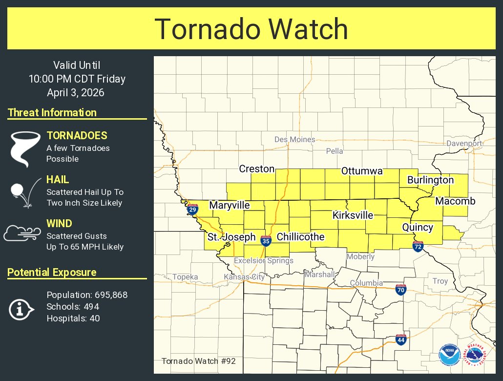
Imma just let yall know- and I won’t be the one to make it happen- but when the Juan de Fuca plate decides it wants to brrrtttt dip a bit, be careful
Keeping an eye on this odd merger, personally.

(apologies for the odd jump cut half way through, new scan came in, and Radarscope for some reason draws it before going back to where the loop was.)
Well it produced a very short lived tornado (was active for... ~2 minutes at most,)

but this storm will need to be watched as it tracks over Bloomington
Bloomington area is likely good now from the lead cell

but another cell further back is now acting up

^didnt do much in the long term
I’m thinking there are lots of dads checking on their sump pumps rn. It won’t stop raining, the ground is completely saturated already, and it’s very flat by me
Well that's an odd one.

that looks relatively close to uluru?
Yes, Uluru is just south of Yulara, which measured the strongest on that list on the right.
Estimated epicenter is at (-26.008, 130.7101) which puts it here

Well I was wondering about the epicenter, but it looks like it is in SA after all...
probably had some fairly moderate/strong shaking, little to no damage really expected to any structures really. (if any are unfortunate enough to be directly in the area)
Also VERY sparsely populated.
Pure "huh, weird" quake, 2nd or 3rd one this year.
USGS confirms the quake happened, prelim of M5.5
https://earthquake.usgs.gov/earthquakes/eventpage/us6000smm5/executive

This makes the distance to Uluru 80 km.
Very long term risk being looked at for western TX/OK, too far out for specifics but something to keep an eye on


Update on how this is looking now, looks like we're in for a decent period of severe weather, starting on Saturday and continuing to atleast Tuesday (Models are not agreeing on Wednesday)


I thought I’d lost my marbles when I saw this but it makes sense I guess; different color gradients for separate days of outlook due to uncertainty
This color scale is only for general risk of severe weather, all 4 days have the bare minimum confidence of 15%
You'll only see 15 or 30 on this, not really a gradient
Whenever we get into Day 3, Day 2, Day 1 ranges is when you start seeing the other colorset for percentages
Here's a note in their documentation for their methodology for creating these longer range forecasts
(Of note for terminology, today is marked as "Day 1", tomorrow is always "Day 2", etc, so Day 4 is three days out from today.)

Right, I was referencing the green/yellow/etc gradient for general severe weather as that’s what I’m used to, but it seems like they chose yellow/orange after day 4
Yeah, not sure why they went with that other than to potentially differentiate it than the 1-3 day
(i might actually email them about that)
(...after this event obviously, they might be a little busy now.)
Lol
They used to issue polygons I guess, and got way too heavy handed with the rating scale
So a moderate risk now would have been severe then, and it ended up being taken less seriously
Well, it's been in this format since rouughly the 2010s?
I can’t fact check you out of personal experience tbh but you’re probably right
And just like that... another era of @NWSSPC outlooks comes to an end. This is the first major change to SPC outlooks in 10-15 years. Excited for the future with the new conditional intensity outlooks! #wxtwitter
Quoting NWS Storm Prediction Center (@NWSSPC)
︀
11:07am CST #SPC Day1 Outlook Marginal Risk: across parts of the southern/central Plains into Missouri and western Illinois www.spc.noaa.gov/products/outlook/day1otlk.html

Looks like ~2011 (to maybe 2014), they added in the Marginal and Enhanced areas
(I'll have to dig through archives and figure out when exactly)
Personal (with no credentials, pure weather nerd hypothesis here) judgement is that Sunday-Monday looks to be the days with potentially the higher threat ceiling,
..However for Monday (the 13th), I am more concerned about MN/ WI, just outside that 15% confidence as of now, would defer to the SPC themselves* as we get closer to the event, but i'd keep it in mind that these risk areas can change, and isn't just limited to these areas, (<15% extends out in theory, as an example.)
(edit for clarity)
I'll hold off on throwing out ballpark guesses that could easily swing 15-30 miles in any direction given on what specific run the models are on until we get closer to the event (and again- i'll likely defer to the SPC themselves at that point, they're the professionals.)
I just feel like it is of slight concern that the risk might be slightly misconstrued for that area during this upcoming event,
Day 3 forecast

Days 4-7


Monday's 15% confidence swath was extended a decent way north, as expected-
Tuesday is also looking to potentially be an upper end day off of current data- i'd be most concerned about Central Iowa (~Around Des Moines) to northern Illinois, all the way to the Great Lakes (~ Chicago)
Full discussion,


The 12Z HRRR run does paint a concerning picture for Minnesota, including the Minneapolis metro.
Beyond a tornado threat, hail bigger than baseballs will be a concern with any established supercells. Dry air aloft, PWATs near 1.2" and steep mid-level lapse rates. MUMBO risk.

Precipitable Water (measuring water vapor in the atmosphere over that area), good chance of flooding conditions when you tack it on with the rest of the environment
But usually PWAT would be used more for looking at hail+ rain risks,
(Which for most of the metro, will be the likely highest risk factor.)
I am personally concerned on if 1-2 storms form in that area,
Ideally, you want either 0 (No risk,) or 20,000 (they smother and suffocate eachother, effectively no risk, still have to worry about flooding+ hail, but no tornado threat)
if 1-2 storms form in that corridor they will try really hard to produce a strong tornado, and it could track for quite a while if conditions really align.
Tuesday we shall see 🙂
Statistically speaking, most likely outcome(and best)- not much happens tomorrow,
worst case scenario. one or two tornadoes of decent intensity.
It’s the “nothing ever happens” vs “craps hitting the fan” dichotomy
There's still a fair few ways this can "fail", among the ways i said above, so we're again in a "low floor high ceiling" type of risk, i would not be entirely shocked to see a theoretical 2-5% CIG2 come out for the first time.
“Low floor high ceiling” is the same way I put it, only I said it much worse
Will say, this new model run- real good news, tornado threat's practically gone this run, hoping it stays that way (effectively hoping the prior runs were outliers, not this one.)
either way, Minneapolis itself is probably dealing with hail+ a fair bit of rain if i had to guess, could get quite pricey off that alone tbh.
At 2:05 PM PDT, 4 SE Vina [Tehama Co, CA] NWS Storm Survey reports Tornado. At 2:05 PM, video and radar evidence confirmed that there was a brief touchdown of a tornado near Vina, CA. No damage was reported. The peak wind gusts, path width and... #cawx https://t.co/ixE1jkXKFf

...Documented tornado in California today, bit of an oddity
I’m not worried about severe weather per se
Actually slightly relating to a case study i have underway, where a tornado W of the Rockies is a good sign that a severe weather event E of the Rockies 2-3 days later is particularly notable-
(Still testing this hypothesis, still completely unfounded officially as of now.)
Real data gatherers only

Tornado briefly touching down in Vina, CA Tehama County #CAwx @NWSSacramento
TX/OK Tornado probs upgraded slightly (2%->2% CIG1)

already have covered parking, but rescheduled a doctor's appt bc this storm looking kinda sppoky
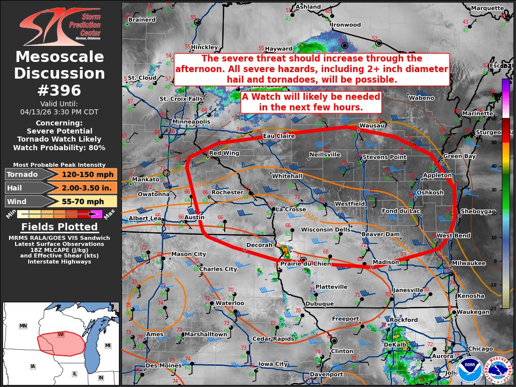
Forgot to talk about this here- but for the Minneapolis metro, tornado threat appears to now be be near non-existent, but hail chances are still present unfortunately.
It looks like the (forecasted) event trended slightly back south after a day or two up north,

Tornado north east of Truman, Minnesota taken a few minutes ago still on the ground. #mnwx
And I’m watching this storm get cracking
Ottawa, Kansas may get a close call, marked as weather spotter confirmed tornado in the warning text,

Tornado in Ottawa, KS


Likely a fairly strong tornado started near/in Ottawa and is continuing NE.
Another video of the Minnesota tornado
https://bsky.app/profile/paulhuttnerweather.bsky.social/post/3mjg3ncpahk2p

Amazing video of tornado west of Amby, MN around 6:30 p.m. from MPR News photojournalist Ben Hovland. Ben reports tornado lifted west of Amboy thankfully. Tennis ball sized hail with that storm!
#mnwx
(or is it a different one?)
W/b the same storm, might not be the same tornado- i know that cell produced a good few quick ones as it tracked from the Truman arae towards the Amboy area.
Ground surveys over the next week or so will clarify that 😅 , very hectic few hours.
Likely tornado ongoing near Mound City, KS

Strong tornado ongoing, just S of Kansas City.

Likely a new tornado from this one- didn't see a CC drop on the 1:30:32 scan, (#1 likely ended S of Pleasanton, KS at around 1:27:50Z, #2 likely started ~ 1:33:30Z, E of Pleasanton, KS)

Estimated path of (what i suspect to be) two tornados near Mound City and Pleasanton, KS-
I'd expect damage from the S side of Mound City around that lake.

Today's tornado forecast.

..already outdated, apologies,
5% in OK extended to KS, CIG2 added to IA/WI/IL


Today has the potential to be a very significant one in southern Wisconsin, northeast Iowa and northern Illinois.
A regional outbreak of tornadoes, some strong/intense, as well as large to giant hail is expected.
Schools in southern Wisconsin should dismiss early.

125 Million Americans are under a severe weather threat today. The greatest risk zone is from eastern Iowa into southern Wisconsin and northern Illinois.
︀︀
︀︀The SPC Warning Coordination Meteorologist, Evan Bentley, discusses these threat areas in greater detail.
Also- this caught me a little off guard, decent shake for Canada

Little to no damage would be expected from this, but probably caught a few people off guard.

Do you know if they distribute those products anywhere else than X?
They're also on the .gov website:
https://www.spc.noaa.gov/products/md/md0419.html
Severe weather, tornado, thunderstorm, fire weather,
storm report, tornado watch, severe thunderstorm watch,
mesoscale discussion, convective outlook products from the Storm
Prediction Center.
and there's a nice way to navigate them just above the mappings 🙂
Yesss thank you so much
Just a heads up though that there will usually be somewhat of a delay between the twitter post going up and the site actually updating to have the same info (Twitter version is usually 1-2 minutes quicker for some reason.)
A tornado watch has been issued for parts of Kansas, Oklahoma and Texas until 11 PM CDT


I missed this earlier, but the watch for IA/WI/IN is 80/60, that's fairly high

Ottawa KS tornado prelim 125 MPH EF2
Hillsdale KS prelim 115 MPH EF2
Mound City has an EF1 DI near it but the prelim isn't quite done yet


Most all of Michigan is under a flood watch their doesn't seem to be a specific, singular product that says this outside of this map? And each of the local offices of course https://www.spc.noaa.gov/products/wwa/
Severe weather information from the Storm Prediction Center.
Ah, that'd actually be under (atleast partially) the Excessive Rainfall Forecast because it's warning about Flash Floods,
https://www.wpc.ncep.noaa.gov/qpf/excessive_rainfall_outlook_ero.php
(chaotic a bit i know, lol)
But yeah, for some of those, there's not really a seperated "split" product to view,
Thank you so much sorry to make you my NWS tutor I think I just could've googled more but I certainly appreciate your help!
It is somewhat weird because the NWS sorta half gave up on having the general public use most of the site
and usually relies on communication via their twitter pages/ office specific pages
Let’s get it
Notable tornado likely ongoing W of Union Center, WI

Upgraded to PDS, the NWS is confident that this is a strong one.
Very rough centerpoint calculations- hopefully missed the small town to the north,

Very long term, Milwaukee might be under the gun from the cell by Watertown.
very rough gist of the terrain this one tracked through- this could (and likely is) off by ~0-1 mile in any direction, as these scans were elevated.

Any expert advice if I DM my area?
TBH, a more "up to date" minute by minute play would likely be covered by https://www.youtube.com/watch?v=Gpf7ssNZQXs
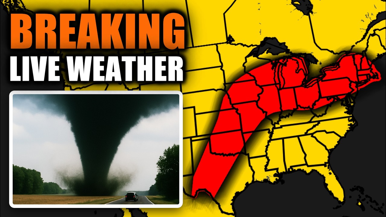
📱 FREE WEATHERWISE RADAR APP:
• iOS: https://apple.co/44wDDKH
• Android: https://bit.ly/42RyZEu
• Browser: https://web.weatherwise.app/
☎️ SIGN UP FOR YALLCALL AT:
• https://www.yallcall.app/
🌡️ WEATHERFLOW TEMPEST WEATHER STATION:
• https://shopryanhall.com/collections/weather-stations
🛒 SHOP MERCH:
• Official R...
I’m watching Max Velocity
I am bogged down with cataloguing potential damage paths a bit rn
That'll be good too
Yeah there's a good chance a big one tries to form W of Milwaukee,
Yup, not looking great


Nice, good info

Main event today is actually this supercell west of Del Rio, Texas (in Mexico) that likely just produced a strong tornado.

Wording's a bit scuffed- tornado occurred in Mexico- we're using Del Rio TX as a reference point
Big tornado W of Milwaukee, WI
Might have been a very brief but notable tornado, lost all signature of it by the time the 3rd timestamp came around

downtown Milwaukee now under a warning from this one incase it cycles real quick
the 1 frame of notable debris (23:27:39 Z), was gone by 23:31:13

Working out the math here- the longest this tornado could have been active for is from 23:24:26- 23:31:13 (~7 minutes),
Although i would go much lower to ~ 23:27:40 for that endstamp as there wasn't any sign of debris by that 3rd timestamp. (~3 minutes)

Incredible drone view of the #tornado east of Onslow, IA @ryanhallyall @WxWiseApp
One of the multiple tornadoes over the past hour, very astonishing footage of this one dying out
Beautiful
I think Milwaukee mostly avoided a bullet off this one, i do not think this storm's going to produce another tornado before it gets over the Great Lakes (if at all)
@tmj4 Reports of a structural collapse in Northern Sussex. May be tornado damage

Radar indicated one in central Ohio, Licking, Johnstown, New Albany in a system northeast of Columbus. I don't think there is as much energy here as these other systems mentioned
Credible reports of a complete structure failure north of Union City, WI, i have an image but no source of said image, i can verify it's the house but... again, i dont know who took it?
UNKNOWN SOURCE- remind me to double back on this and really find who took this
but this is at 43.690434, -90.293082


^my main concern is that it looks cropped from something (video?)
My photo of the home leveled west of Union Center, WI #wiwx
Quoting Nick Krasznavolgyi (@NickKrasz_Wx)
︀
Egan shared a few photos with me from the Union Center, Wisconsin tornado earlier today. I will not share them here, but here are some observations I made.
︀︀
︀︀Information on this home:
︀︀
︀︀N1503 Raese Rd, Elroy, WI
︀︀
︀︀- Single-story residence with a walkout basement (effectively two stories)
︀︀- Constructed in 2000
︀︀- Structure largely destroyed; most debris swept from the foundation
︀︀- Some subflooring and floor joists remain on foundation
︀︀- Majority of the home is gone
︀︀- Foundation appears to be secured with concrete nails, suggesting lower-end anchoring/construction quality
︀︀- The damage in my perspective supports at least a mid- to high-end EF3 rating (150-165 mph), though, this is up to the National Weather Service in La Crosse, Wisconsin.
︀︀
︀︀Thankful the homeowners weren't there, it…

LOUD video OTUS Project flies a 360 degree camera (via a drone) into a tornado from today,
||https://x.com/Jeff_Piotrowski/status/2044248134067306579||
^broke the embed intentionally and formatted it like that to hopefully protect your ears, or give you a heads up.
It's not graphic in the slightest, just harmful in a different way to the viewer.
Thank you for that warning! I should have heeded it more 😂 I see what you mean though, it's very loud.
That's a really cool video!
Next two forecasted days (today+ tomorrow) should be somewhat "calmer"- and i will use that to get some rest,
(General outlook+ tornado probs)


Friday looks like it may be of note.
(General outlook+ risk of hazardous conditions, [wind, hail, and/or tornadoes.])


PNS issued by NWS ARX at 15 Apr 2026 20:15 UTC
Prelim of 140 MPH EF3
Today's tornado probs,

I’m getting sick of this weather now
It does seem like the weather dislikes the driftless area in particular.
If it helps i'm looking much more at IL for tornadoes today (mainly the 2% and 5% CIG1 parts), so like Peoria, Bloomington, Springfield,
And i'm not exactly confident they'll really be strong tornadoes even possible today (maybe 1 if everything lines up perfectly), but this s/b much more of a wind threat today as these storms congeal into a line.
(We might see a 60%+ special upgrade during the event, will be the first time that this new system's seen a derecho-esque* event
(*Derechos are "officially" classified after the fact, and require some weirdly specific width+ path length conditions.)

Image #1- all you really need to read if you're looking in,
Image #2- pure in the weeds/ more specific discussion.


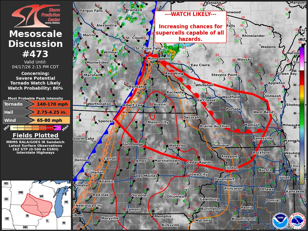
Slight update- they added a CIG2 area for their wind forecast, which does bump the event up to a MDT day for KS/MO

^CIG2 for wind probs means that the SPC is somewhat confident that these storms in this area could produce wind gusts of >70 MPH (but likely not >90, but cannot be ruled out.)

https://www.kaaltv.com/live/ First tornado for today- S of Rochester, MN

per 511mn.org

Yeah, hat tip to @quaint flame that Minnesota has a massive number of road cameras. If there's reports of tornadoes there's a chance it's getting streamed by MnDOT.

https://weathercams.faa.gov/map/-269.17187,10.30191,33.17188,75.58165
FAA Weather cams might be useful too
WeatherCams
FAA weather camera imagery, aviation and weather data, flight planning and weather monitoring tools, and other resources for pilots, forecasters, ...

Meteorologist Ben Dery was live on KARE 11+ as a tornado formed near the Rochester airport Friday.
Another one near I-90.

Yeah that's a strong one near Marion MN,
Bogged down w/ logging paths, refer to the NWS for more updates. Event's kicking off much more than i originally expected.
The strong one's probably gone by now, but there's a lot of "areas of note" that may have produced very quick spinups.
This is very bad.
Pick a storm, it's rotating, and i'd say 10% of those have already produced a tornado
All in that same area of SE Minnesota?
Split, se MN, ne IA, nw IL
Also parts of sw WI and ne KS.
(Part of state in lowercase, state in uppercase.)
Likely had another strong tornado just miss Plainview, MN.

We are currently at 13 tornado warnings, 3 confirmed as of now. (Not including tornadoes that have lifted.)

Insane video coming in from the tornado that impacted parts of Marion, MN. It does seem like there was a lot of debris in the air, hopefully everyone is alright.
︀︀
︀︀Credit: Emily Ann (On Facebook)
Another one from this one cell, W of Waumandee, WI
Also likely strong as it passes between there and Cream, WI.

This is unfortunately likely a violent one as it tracks over some farms along County Road EE, E of Cream, WI.
This may hit Montana, WI, or come really close to it

Tornado moments ago by Montana Wisconsin. #wiwx #tornado @NWSLaCrosse @NWSTwinCities
Strong tornado likely in Lena, IL right now.
Let’s go
This is one of those days where i'd be amazed if there wasn't a fatality, especially for the tornado that went between Cream and Waumandee, WI.

2.5 mile wide debris signature is off the charts
Is that the one in northern Wisconsin? NWS is putting out warnings up there; it's mostly rural but there's a large Mennonite population there.
~80 MPH wind gusts going into Ottawa, KS
They were hit by a tornado a few days ago

Tornado Warning continues for Roscoe IL, South Beloit IL and Rockton IL until 5:15 PM CDT

If this continues, there is no way it misses Rockton/Beloit.
Roundup of what happened in SE Minnesota:
https://www.mprnews.org/story/2026/04/17/tornado-sightings-and-damage-near-rochester-weekend-chill-ahead

MPR News
Severe storms dropped at least one tornado in southeast Minnesota Friday afternoon.

Luckily- fairly light damage seen so far in Belton, KS
(Source- https://www.facebook.com/share/p/1FToqpFehn/)


Ponca City, OK might have been hit too by a quick spinup
would have gone through the southern side of the city.


Milwaukee WI got spared again, quick spinup lifted just prior to town.
From 00:58:43 Z to 1:02:11


Hopefully things are winding down somewhat, should be transitioning more into a straight-line wind risk... im going to try and get some sleep
Thanks for the hard work; we appreciate ya
Couldn't tell if you found the source for this, pinging in case u still wanted a reminder, apologies if i misunderstood
Next post down I did
April 17th severe outbreak warnings as of 11:40 pm
- 140 Tornado Warnings
- 283 Severe Thunderstorm Warnings
What a day
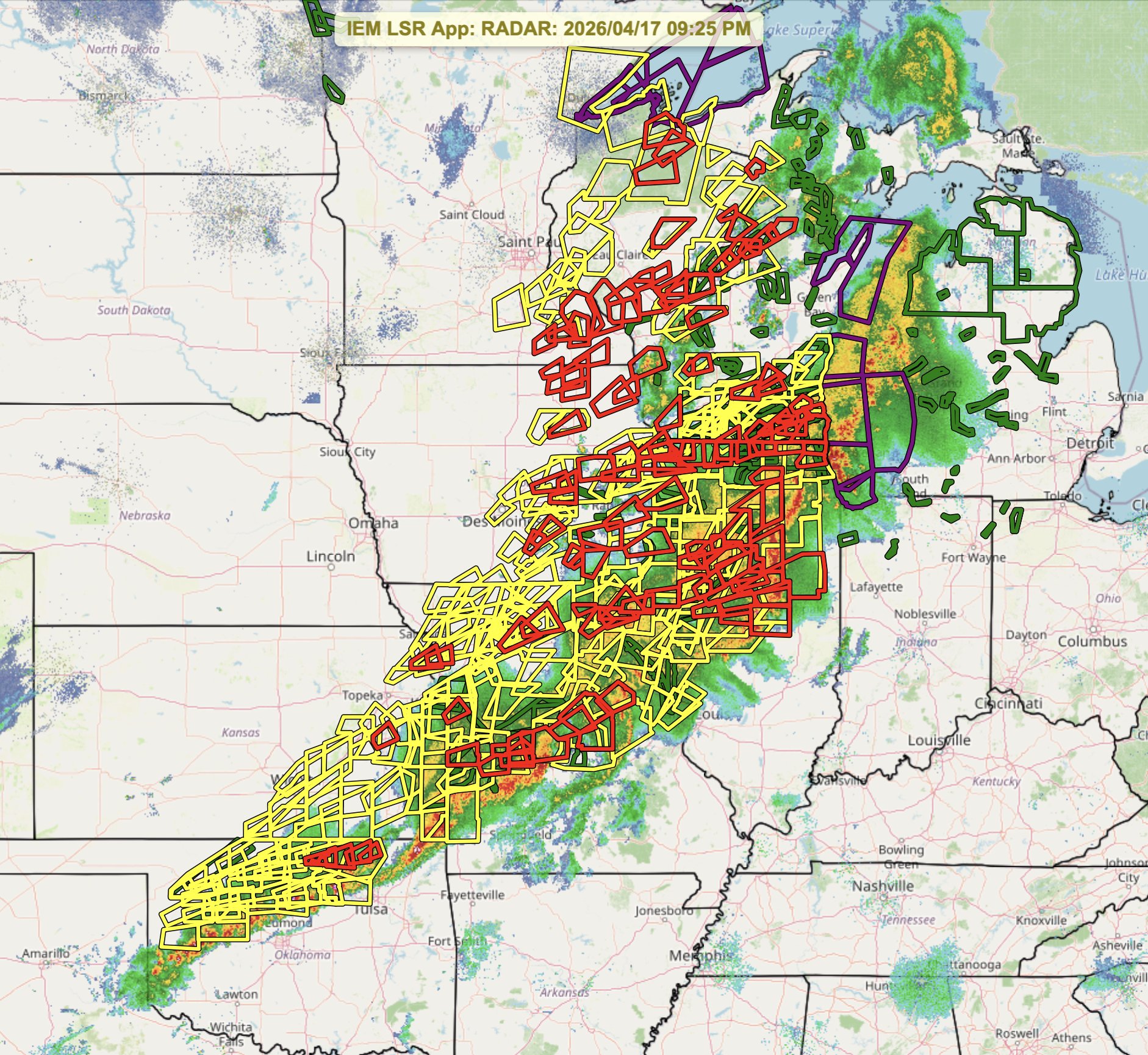
https://fxtwitter.com/ryanhallyall/status/2045579866725097929
(For context- i sent the quoted message at ~2:58 CDT)

Here's a timeline showing the 150 tornado & 300+ severe thunderstorm warnings from yesterday..
...might have another event to look at come Thursday

Notable quake, preliminary info: M 7.4 - 100 km ENE of Miyako, Japan https://t.co/PaK3rwBOxI
I’ve seen 7.7, suspected foreshock
Alright, got quite the doozy of an update here, bear with me.
First off- Thursday, looking at somewhat of a more "general annoyance" threat


Secondly,
Thursday may be the start of another multi-day severe weather event mostly for the OK/AR/TX sort of area up until atleast Monday, possibly Tuesday?


Tornado Warning including Old Fig Garden CA, Biola CA and Rolling Hills CA until 2:45 PM PDT
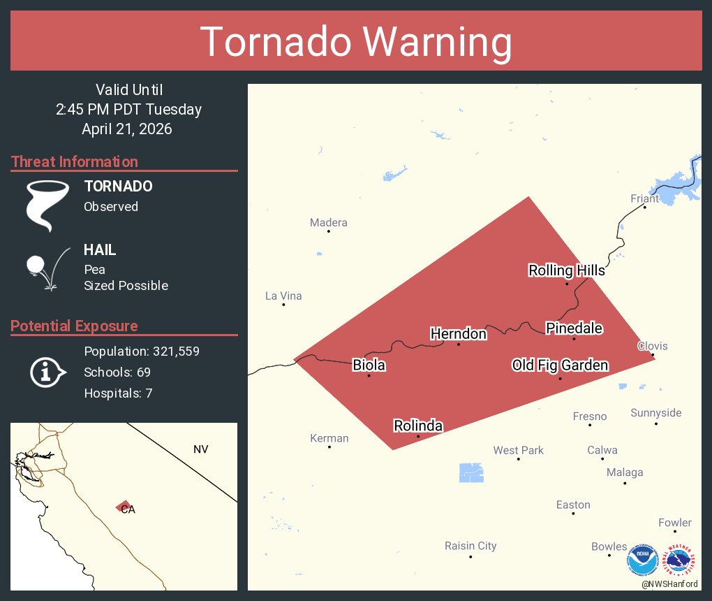
Funny statline for 2026 so far, California has had more observed tornadoes than Dixie Alley's had warnings
(This will very likely change by the end of next week.)

huh, its always facinating to see em form live
Pineland, GA fire. (Currently estimated at ~8,900 acres)


Today's overview


Yeah it's lookin like this will be real damn powerful tornado, and it's very deviant, this is a very scary one


Might have lifted just before the small town luckily, lot of empty farmland in that area so it's really hard to tell where exactly it is via radar.

Notable tornado went through the Vance Airforce base in Enid, OK


Tornado warnings have been issued and confirmed tornadoes spotted as severe storms track across Oklahoma. Updates here: https://tinyurl.com/zhdp6csw
Dear lord.

TOR-E issued.
MAJOR, EXTREME DAMAGE TO HOMES S OF ENID, OK
︀︀
︀︀HOMES LEVELED, DEBARKING, SCOURING #OKWX

I think it did a loop JUST south of Enid,

a little refined and very scuffed estimated centerpoint track.
(The more "?" i have on a tag, the less certain i am that it is of the tornado and could be debris fallout)

Some very bad damage reported around (36.336238, -97.888136)
(very early in the path as it crossed the 81.)
Closest i could line it up.
(Source- https://fxtwitter.com/K13News/status/2047506951370617112)


BREAKING: Major damage in southeast Enid, OK after a large tornado moved through the area.
Managed to aquire a (much) higher quality of the 360 pan video,
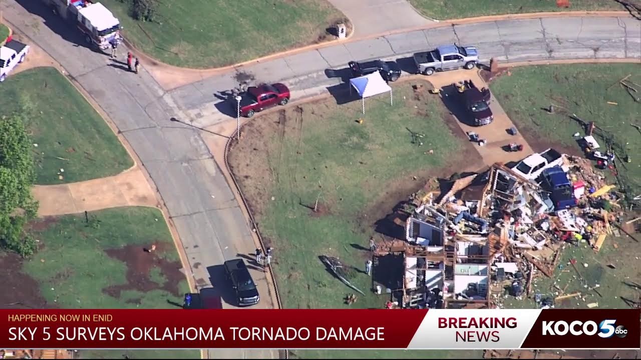
OKLAHOMA TORNADO DAMAGE | Watch live as Sky 5 Pilot Chase Rutledge surveys damage after a large tornado hit Enid late Thursday. Learn more here: https://tinyurl.com/mr2dejw6
Video starts looking at the entrance of Gray Ridge (around 36.339671, -97.888849 ), just E of Vance AFB
My charting using that flyover w/ my "Threat To Life" system (because i cannot account for how well constructed these homes may have been)


https://x.com/NWSNorman/status/2047715200359428302/photo/1
NWSNorman already indicating EF3+ for this area
Some of the damage our crews are finding in Enid this morning. At least EF3 damage has been found so far in the SW side of Enid. #okwx

We found several points of EF4 damage southeast and southwest of Enid from the tornado last night. Damage surveys still ongoing, but we have found EF4 damage. #okwx

The loops have been added (and how close the first one came to hitting extreme southern Enid.)


This moment on the map corelates w/ the replied video for the Braman OK EF1

Today's severe weather outlook+ tornado probs
(Hail driven MDT, tornado probs aren't quite that high, but if storms do fire off for eastern Oklahoma it won't be pretty.)


And closer zoom for OK itself for general context.

It’s honestly scary that the NWS Tulsa Forecast Discussion is reminding people to have a shelter plan "no matter where you are at" tomorrow. ⛈️
If you have plans away from home mid-afternoon into evening, please keep safe & have a way to get alerts. Tomorrow looks like a day not

Some recent news about the Camp Mystic floods in Texas last year:
https://apnews.com/article/texas-floods-camp-mystic-c7c71d2431612bcbdaab83eaf0a170d4

AP News
Texas state regulators found nearly two dozen deficiencies in the emergency operations plan submitted in Camp Mystic’s bid to reopen less than a year after 27 children and counselors were killed in a flood.
Another day of (potentially significant) severe weather unfolding today,


3:50 pm - Rapid storm development is imminent in southern Oklahoma. Expect supercells to develop with very large hail and a medium tornado risk.
If you need extra time to shelter from severe weather, start thinking now about what you might need to do this evening.


Tornado Warning continues for Archer County, TX, Clay County, TX until 7:30 PM CDT


Dangerous conditions in the short term for Fort Worth, TX.
If you are in or near Fort Worth TX, 90 (+) MPH straight line winds are about to roll close if not through the western part of the area.
Likely an ongoing tornado heading into majorly populated areas, NW of Fort Worth, TX.


Tornado Warning including Saginaw TX, White Settlement TX and Azle TX until 11:00 PM CDT
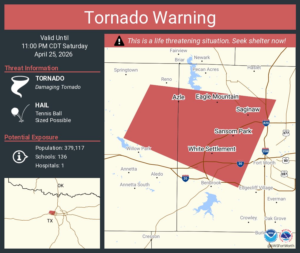
Current radar frame, slight right hand turn, main threat has shifted to Fort Worth itself.

Also associated w/ this storm, 70 MPH wind gusts+ ~2 inch hail,
Even w/ the tornado threat aside this still would be quite the damaging event for the city
No longer an observed tornado, focused more on the wind+hail threat for the city now.

Tornado Warning continues for Nashville AR, McCaskill AR and Clow AR until 11:30 PM CDT

Hopefully everything starts winding down fairly soon, especially after the heart attack that was the Fort Worth situation,
Some damage reports coming in from that storm, but s better picture will come in the morning.
Tornado Warning continues for Cherryvale KS and Sycamore KS until 7:45 PM CDT

https://www.facebook.com/reel/4424696071121358/?s=single_unit
Source- Charles Peek, Sycamore KS


Tornado in progress northeast of Burbank, Oklahoma
︀︀
︀︀@NWStulsa @NWSNorman
**👁️ 1 **
Tornado Warning continues for Baxter Springs KS, Columbus KS and Riverton KS until 10:30 PM CDT

Tornado Warning including Joplin MO, Carthage MO and Webb City MO until 10:45 PM CDT

Downgraded from PDS before it got into the city, not even marked as Observed atm,


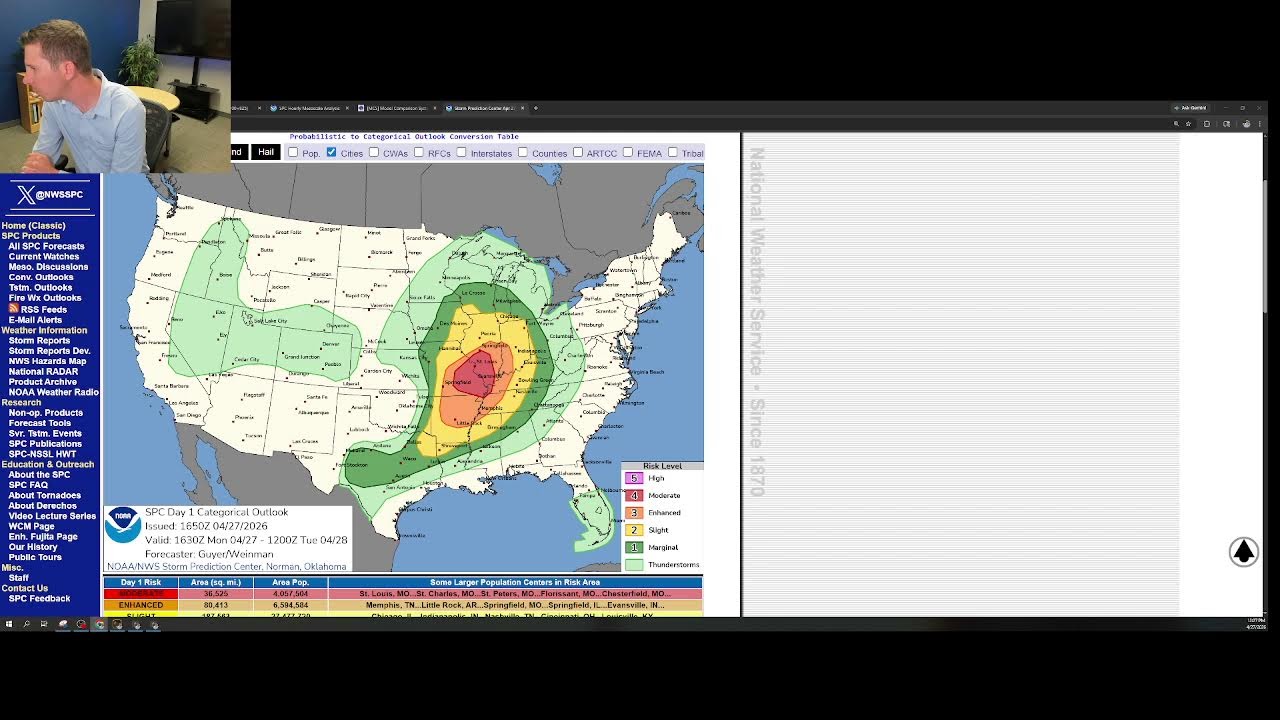
57 likes. "Strong to Intense Tornadoes Expected across C/SE MO and southern IL today (April 27, 2026)"
Er, the SPC is going live on YT in about 10 minutes to talk about and answer questions about today's event, this is a first.
That stream had a few hiccups but overall was a pretty good first test run, I personally hope they continue doing those- seeing them answer live questions from the general public was a plus.
A tornado watch has been issued for parts of Illinois and Missouri until 9 PM CDT

80/60 tornado probs.
A coworker of mine is sheltering due to the tornados. Wild knowing someone affected by thid
TBH- low odds that this first one (straggler from last night) prodcues anything of note, but i'm worried it may make certain people think the threat is entirely over today,
It's the next wave that this watch and the focus is currently on

A tornado watch has been issued for parts of Arkansas, Illinois, Indiana, Kentucky, Missouri and Tennessee until 11 PM CDT

That's high.


I think I need to set a boundary with my coworker cuz when we talk tornadoes, we go off
You shouldn’t lol. Invite more people to the convo

@unborn timber figured you’d appreciate. Getting alerts via text

Heads up for most of this event so far down south- still got the concerning environment, but no storms to use said environment as of now,
If something starts up it'll be watched like a hawk, but for most of the "main" risk area today (Mainly around St. Louis), i'd say that area certainly underperformed today luckily, but more eyes are now veering south to NE Arkansas, W Tennessee, and SW Kentucky.
(But personally, if those issues continue, that area will also see a very similar outcome.)
Cowabunga it is. The storm in DFW went from watch to warn in 30 minutes. This… this’ll be interesting at minimum
QLCS tornado tracking into Trenton, IL

And it either died off or took a very hard turn, either way, decently confident that town's safe from this specific one, lost all standard radar indicators that a tornado w/b active here.
Another one to the E of Germantown, IL (roughly same area), heading towards Beckemeyer.


Closest hook echo to me


Quite the long tracker.


Estimated centerpoint tracking+ terrain in image #2 (looking EAST)


A tornado watch has been issued for parts of Arkansas, Louisiana, Oklahoma and Texas until 7 PM CDT

Yesterday will be studied for a completely different reason that originally presumed.


Entire building leveled
︀︀
︀︀Mineral Wells
︀︀
︀︀@NWSFortWorth @ryanhallyall @MaxVelocityWX
very old warehouse, likely just shoved off it's foundation (note the pallet's still remaining on slab.)
32.818544, -98.057627


Likely not as strong as originally presumed, (still notable damage, but reeling in expectations.)


🚨🌪️ One of our NWS storm survey teams has confirmed that an EF-3 tornado with winds up to 145 mph occurred in Mineral Wells yesterday evening. This is still preliminary and subject to change pending final review. #dfwwx #txwx
Looks like this (thankfully) missed all populated areas, pure tree eater of a tornado,
(likely strayed south of this area, and radar wasn't getting a good scan)

As a heads up for today's event, Birmingham's radar (Central AL) is down, and is not expected to be repaired for a few days.


Only cell of real note so far, approaching Tylertown, MS

Strong tornado SE of Sibley, MS

Tornado Warning continues for Bude MS, Roxie MS and Meadville MS until 7:15 PM CDT

Tornado Emergency continues for Bude MS, Roxie MS and Meadville MS until 7:15 PM CDT

upgraded to a Tornado Emergency,
Another strong one (already went PDS) S of Hattiesburg

Went through some very populated areas
TDS swath indicating a long tracked tornado for potentially 20 mi near Garden City. Strong signs of EF3+


Notable quake for Chile,
Given the area it hit, probably lighter damage to some surrounding towns- estimated epicenter is pretty rural.
I'm not a weather expert, but this sounds... bad
https://www.bbc.com/weather/articles/cvgzn11v421o

BBC Weather
As El Niño develops this year, scientists are increasingly confident it could be one of the strongest on record with global consequences, as Simon King explains.
I’ve talked with my parents about climate change, they’re right wing. But we all agree the climate is changing
That’s comforting to hear

KSTP.com 5 Eyewitness News
Amid many fires across the state of Minnesota, a firefighting plane was hit by what appears to be a bullet on Friday evening, according to the St. Louis County Sheriff's Office.
Today's Outlook+ breakdown by hazard type
IMO- Today will probably be known more for wind+hail damage in NW Iowa/ SW Minnesota.


tomorrow has my eyes, tornado-wise (SPC has the "main area of note" being Central/NE Kansas into SE Nebraska, but if I was chasing, i'd be in southern Iowa.)
(Current D2 tornado outlook, my "area i am curious about" is just NE of the 15% CIG2, nesteled solidly in the 10%CIG1 area.)

Likely strong if not intense tornado ongoing N of Saint Libory, NE.


▶ Play video
FxTwitter
·
A couple of storm chasers about died today,

Just intercepted an absolute MONSTER at close range north of St. Libory east of Hwy 281. Homes destroyed. Checking on folks now
DOW A’s view of the tornado near Saint Libory, NE at 2 different times
︀︀Image 1: 2211 UTC with eye
︀︀Image 2: 2213 UTC with debris ball
︀︀#newx


Image #2- satellite tornado seen- VERY good scans from DOWA today!

Tornado Emergency including Hebron NE, Alexandria NE and Gilead NE until 7:30 PM CDT

Not confirmed to be active as of now, but an area of rotation is approaching the Omaha, NE area.

I am reviewing (and making a mini case study) over 3 seperate chasers who all came very close to being impacted by the Saint Libory, NE tornado.
they will be marked as incident "26518-A", "26518-B", and "26518-C" with an additional "U-26518-D" (Unknown person.)
Initial review suggests that
-
[26518-A] drove across the tornado's path at a very high rate of speed in an attempt to escape, driving E,
-
[26518-B] drove into the path of the tornado, had to reverse out (cutting off A in the process,) before successfully bailing north
-
[26518-C] is mainly just here for his footage, I personally believe he cut it close but he was able to turn and bail north before B turned.
-
[U-26518-D] drove north into the path, quickly did a U turn and bailed back south. Still looking to identify if this was a local or a storm chaser.

Car A did some unbelievably reckless moves, they escaped being hit by the tornado by ~3 seconds.

A strong tornado moved through Nebraska just south of St. Paul.
I got in a very close position relative to the incoming Tornado and had my escape routes planned and ready. I managed to get a perfectly timed escape with some crazy footage out of it.
Although a relatively short-lived tornado, devastation was not escaped.
Support my chasing by d...
(Originally was going W, one chaser IDs that the tornado is "going right at them", they proceed to stay and film for ~40 seconds, then pull a U turn and go E, they get to "intersection of note" at ~3:00, tornado damage occurs to structures at intersection at ~3:05.

WDIO.com
A suspect has been identified in the investigation of a fire bomber struck by gunfire while assisting on a Portage Township wildfire.
Oh snap
You could refer to the county (Warren, right?) and that should get the message through.


A livestream of a volcano in the Philippines captured a meteor crashing to Earth today. What are the odds?
Mayon Volcano, Location: Albay, Luzon, Philippines
Reposts
6870
Likes
20463
Quotes
1299
Replies
446

Manila Bulletin
A meteor was recorded passing over the slopes of Mayon Volcano on Monday evening, May 25, according to the Philippine Institute of Volcanology and Seismology...
A meteor was recorded passing over the slopes of Mayon Volcano on Monday evening, May 25, according to the Philippine Institute of Volcanology and Seismology (Phivolcs).
Phivolcs said its Ligñon Hill IP Camera in Legazpi City captured the meteor at around 10:33 p.m., but noted that it disintegrated while still in the atmosphere and did not reach the slopes of Mayon.
#alwx
︀︀Geolocated Henry County AL tornado damage (31.337269, -85.280711)
︀︀
︀︀@NWSTallahassee
︀︀
︀︀Image from www.wtvy.com/2026/05/26/apparent-tornado-touches-down-near-dothan-damage-reported/
︀︀(Source is cited as WTVY themselves)


Interesting note- if my math is right- the only clear photo of this tornado is as it was over this exact area.
FORWARDING for @NWSTallahassee Local photo of the Dothan, AL tornado by Shaw Watkins
︀︀
︀︀Geolocated to ~ (31.359922, -85.297418) looking SE, tornado looks to be around Henry County 15 ~ (31.337011, -85.279156)
︀︀
︀︀www.facebook.com/share/r/1CyhcGqdM4/


And interesting lil calculation work (blue line: radar-derived path estimation, this is expected to be off by ~0.1 to 0.2 of a mile in either direction due to not having surface level data, but it is close enough for me to roughly work out where the tornado was at the time of the photo, and roughly when the photo had to be taken, around 00:46:18 Z)


CC to @unborn timber