#Weather and geological phenomena
1 messages · Page 4 of 1
(I dont have access to too many stations there so number is likely wonky)
JQuake put it at an estimated M4.3

CNN
National Weather Service offices around the country are on guard after recent threats to agency infrastructure — specifically Doppler weather radars — from a violent militia-style group, emails from the National Oceanic and Atmospheric Administration’s security office show.
For fellow weather nerds- would look into WeatherFront,
https://x.com/WxFront
Welcome to a new era of weather monitoring on a mobile device. Download free for iOS today: https://t.co/f6FgAJ8yCx
Waiting for them to make an android version tbh

It seems like the best combo of RadarScope (which is my current go to) w/ the amazing road networks that RadarOmega has,
yeah it would be nice if it were on Android since my only iOS device I have is my wifi-only iPad :P
looks like they're working on Android and desktop versions
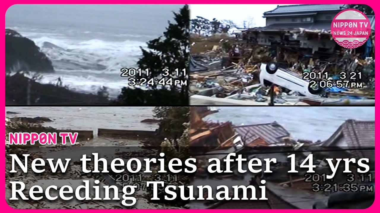
Fourteen years after the Great East Japan Earthquake, videos that had not been made public before show the horrors of receding tsunami and lead to new theories that experts had not thought of before. The new discovery is expected to help formulate countermeasures for future disasters such as the anticipated Nankai Trough megathrust earthquake.
O...
tl;dr- New video archived from a survivor during the earthquake shows that waters started receding in this area (violently!) way earlier than neighboring bays, (5-10 minutes prior)
Still being researched, but they're leaning towards geographical influences obviously


us storm nerds like to call this type* of event a "low floor but a high ceiling", where the overall risk could easily be dirt poor, or you could practically shoot for the moon
(*How was that typo'd for 2 days :C)
"if it goes off it will go the fuck off"
“Get some whiskey ready. Either in disappointment or in sheer ‘I need to mentally manage this shit’”
a real catch-22% situation
Update on this- models are lookin a little more NE now

the blob has changed
On March 28th, 2025, a magnitude 7.9 earthquake struck Myanmar, causing a rupture in about 460 kilometers (290 miles) of the Sagaing fault line that runs through most of the country, causing shaking of at least intensity X on the Modified Mercalli scale. As heavy shaking was felt throughout much of Myanmar as well as other neighboring countries,...
Every... time... i post an update the NWS updates it too.

what's the hashed area again?
10%+ of significant conditions w/in 25 miles of a point.
ah ok, thanks


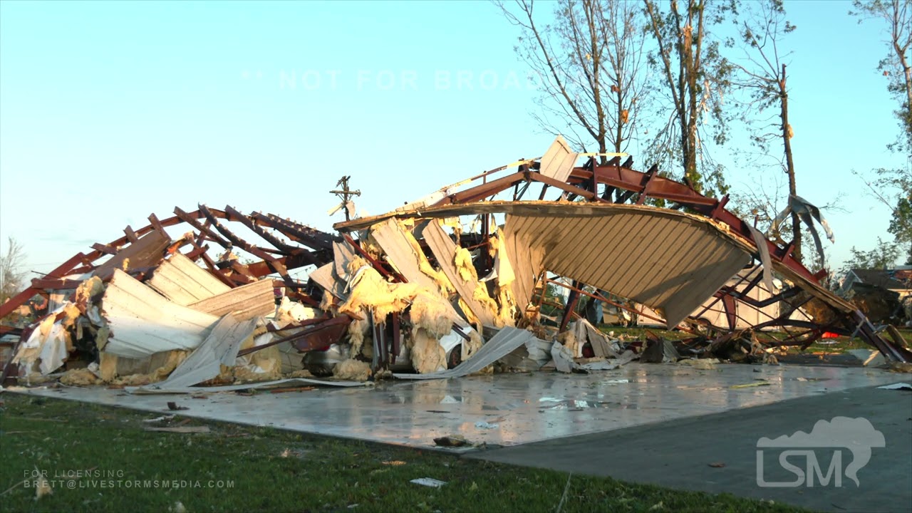
Juneau+ Mayville, WI both hit by decently strong tornadoes (powerlines downed, roofs ripped from buildings.)

Radar scans of both areas being hit.


https://www.severestudios.com/storm-chasers/jordan.hall.html
Per a stormchaser on scene.


"Several strong[EF2+] tornadoes are expected, and a long-track high-end tornado[EF4+] will be possible"
"Several strong tornadoes appear likely, and a high-end long-track tornado will be possible from far southeast Missouri, into southern Illinois and southern Indiana, southward into western Kentucky and far northern Tennessee."
BTW- yes there are currently tornado warnings for AR/TN (And probably soon for KY.)- this is the prelude to the main event, if you happen to be in these areas- it's the 2nd wave everyone's concerned about. I'd suggest you stay tuned to your local NWS office. (You always should have some level of alerts active at all times, but it doesn't hurt to follow your local area on Twitter- they'll give you direct alerts for your area.)

https://fxtwitter.com/i/status/1923493333911076990
38°40'10.21"N, 90°14'9.64"W looking S/SW.

More visuals coming in from north of St. Louis, Missouri — the aftermath of today’s powerful tornado.
︀︀
︀︀Homes shattered, debris everywhere. The damage is extensive.
︀︀
︀︀#Tornado #Missouri #StLouis #BreakingNews
**❤️ 1 👁️ 206 **
Baltimore, MD under a tornado warning, merger event


▶ Play video
 FxTwitter
·
FxTwitter
·
^Likely much weaker than typically expected- looks like it shifted off it's foundation and failed.

"Risk to life" assessment thanks to this source
https://www.facebook.com/20002104/videos/pcb.10105644827707021/1204887194551924
explaination of my scale here- these are not correlating to any sort of EF rating, this is a pure "risk to life" sort of assessment using footage.
Green- little to no risk to an occupant inside the structure
Yellow- Moderate risk of injury (Low risk of fatality)
Red- Moderate risk of significant injury (Moderate risk of fatality)
!!!!- High risk of significant injury (High risk of fatality)

Red marker at the south, then the !!! point just to the NW
Luckily- looking at Google Maps- both of these specific buildings seemed to be abandoned (but neighbors directly next to them were not)- But, my experimental scale works on the idea of "if someone was inside"


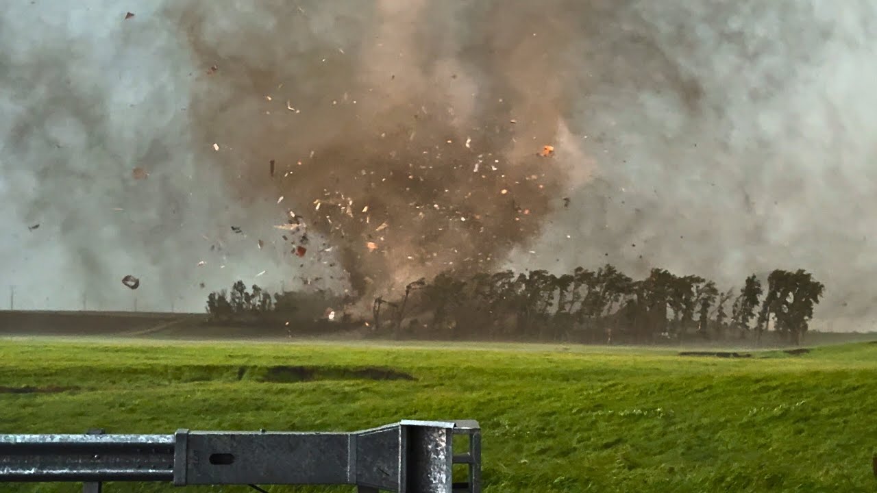
Strong/violent tornado near Marion, IL.

Very likely hit USP Marion
https://en.wikipedia.org/wiki/United_States_Penitentiary,_Marion

The United States Penitentiary, Marion (USP Marion) is a large medium-security United States federal prison for male and female inmates in Southern Precinct, unincorporated Williamson County, Illinois. It is operated by the Federal Bureau of Prisons, a division of the United States Department of Justice. The facility also has an adjacent satelli...
Tornado emergency issued
Bloomington, IN! Another strong one!


▶ Play video
FxTwitter
·
OMG Wicked #tornado in progress in Haywood City, MO! Time 6:46pm

Different- North of Allegre, KY, Strong.

very notable, if not historic event unfolding.
S of Nashville, IL

There's a debris spike on that one- that's real strong.

It's gonna try to track straight through Columbus. Next 10 minutes or so
SW of Evansville IN, near Morganfield, KY, another notable circulation trying real hard to produce another strong/violent tornado. Insane inflow on this supercell- will be undergoing a merger that will (very likely) be constructive.


Morganfield KY, insane risk, that cell's gonna go.
Very rapid rotation seen via Brett Adair

Follow me on Facebook!
https://www.facebook.com/MeteorologistBrettAdair
Follow the LIVE Stream Here!
https://stormchasinglive.com/
Follow our tower cams LIVE here!
https://hazcams.com/
Download our Weather App in Weatherwise - IT'S FREE!
https://weatherwise.app
A severe weather outbreak is possible across the Missouri Valley region this ...
It looks about guaranteed to be a strong one, imo,

▶ Play video
FxTwitter
·
Different tornado- but these storms are dropping tornadoes left and right, the moment they get a chance it's going
Strong tornado, SW side of Morganfield, KY,


Strong tornado approaching Somerset, KY.


Once you get over towards London KY- you hit the Appalachians, Storm could get real funky.
PDS issued for London KY, a spot I've jokingly called the "Hotspot of the Appalachians" before.


▶ Play video
FxTwitter
·
This hit real close to home- Significant damage reported.
God,

If this goes slightly more north it will be an utter catastrophe for London KY in around 15-30 minutes.
night time
tornado
That’s a whole lotta nope on that train, goddamn

Southern side of Somerset hit, I know this area,
This is a combo of NWS understaffing and an NWS slip up incident for sure.
- Hearing NWS Chat from the Jackson, KY office has been silent since 6:16pm
- They can not issue a Tornado Emergency because they can not get upper management approval (they don't have any sort of upper
E of Somerset, 2nd tornado.
Mass casuality situation declared, Somerset, KY.


US27 is closed until further notice from Bob Evans to the Somerset Mall. Entire area is devastated. Gone or badly damaged are: South End Speedway, Lutheran Church, Baxter’s Coffee, Hardee’s (south) and possibly the theater. #kywx
Most intense winds estimated at under 300 ft wide from this announcement.
rough estimation using the buildings listed.

@ryanhallyall
The air evac and PHI medical choppers were destroyed at the London/Corbin Airport

event should wind down now, going to sleep,
Breaking News: Multiple fatalities now confirmed in London in Laurel County after tonight's tornado. #kywx

This is a look at the damage at Sunshine Hills in Laurel County.
︀︀Find the latest information on our website: www.wkyt.com/2025/05/17/tracking-severe-weather-damage-southern-kentucky/?utm_source=twitter&utm_medium=Social&utm_campaign=snd&utm_content=wkyt

NOT FOR BROADCAST
Contact Brett Adair with Live Storms Media to license.
[email protected]
Initial Damage videos from Somerset Ky tornado
btw- local lore, the exact intersection that tornado hit directly (Light 22) is considered a "cursed" light. There's a facebook group made that documents every single car crash or oddity (such as a "dropped plant pot from the back of a pickup truck") at that specific light
There were cameras set up at that light to document this stuff, if it survived- expect footage of it soon.
One of the most documented traffic signals in all of KY.
If footage survived- it'll be here. https://www.facebook.com/ModernSystemsInc


Tornade près de Morganfield, Kentucky, à 19h24 heure locale.
︀︀
︀︀Tornado crossed road 130 near Morganfield, 7:24PM. #kywx
Now i've seen it all- French storm chasers in rural western KY.
south of London KY,


At least an EF4 tornado struck the city of London, Kentucky overnight. #drone #video shows the destruction left behind. Homes flattened, cars thrown and flipped. Entire neighborhoods gone.
#weather #cinematic #aerial #footage #tornado #damage #2025 #kentucky #tornadooutbreak #severeweather #storm
Licensing via www.wxchasing.com
Most interesting part of the video i've seen so far


0:45 in- That cyan segment- it's missing
jeez what a mess. those poor people
(Don't worry- getting closer segments, trying to not have automod snipe me for too many attachments.)

Blue- No Damage/Other
Green- little to no risk to an occupant inside the structure
Yellow- Moderate risk of injury (Low risk of fatality)
Red- Moderate risk of significant injury (Moderate risk of fatality)
!!!!- High risk of significant injury (High risk of fatality)


A Kentucky State Police Bell 407 is active surveying the damage over London, KY.
N284SP


The death toll is likely to rise, according to Gov. Andy Beshear. https://t.co/f0zYeS8fGi
NOT FOR BROADCAST
Contact Brett Adair with Live Storms Media to license.
[email protected]
London, KY disastrous scene Saturday morning. Video shows people going through their belongings. Destroyed aircraft and leveled buildings at the London Airport/Industrial Park. The Medical Evac helicopter was destroyed but the crew was spare...

Not for use or broadcast without permission. Send a message for usage.
Holy, in-between Somerset and London KY.

Significant tree damage.
The scar the Somerset-London KY tornado left behind in forests is MASSIVE.
Image source: https://t.co/GIqHe9v7eT


AMETSOC
Abstract Enhanced Fujita (EF) scale estimates following tornadoes remain challenging in rural areas with few traditional damage indicators. In some cases, such as the 27 April 2011 tornadoes that passed through mostly inaccessible terrain in the Great Smoky Mountains National Park and the Chattahoochee National Forest in the southeastern United ...
An old study from 2017 I remembered about
Canadian process on assessing forest damage (KPH NOT MPH)
I know this isn't exactly 1-1, but literally the US side does not have a good system for accounting for swaths of forest damage like seen above

Area highlighted in red (both graphs) is where the most catastrophic damage occured-
Geography-assisted winds, almost certainly.

Tornados weaken going uphill, and strengthen going downhill (vast oversimplification)
tornado descended around 89 feet (vertically) within seconds. (spanning a distance of 2k feet long)

This is extraordinary video. Wait a few seconds and watch the debris cloud at the surface grow and swirl. Amazing.
scale of the UAVs starting to be used in the OTUS project.
https://x.com/project_otus/status/1789672059385074120/video/1

It seems that this tornado yesterday north of Sikeston, MO is preliminarily rated an EF3 with 152mph max winds

*OUTBREAK of tornadic supercells possible Sunday/Monday (and perhaps Tuesday) across the Southern Plains and Arkansas*
Arguably one of the more classic dryline severe weather setups since 2016 is taking place across the central and southern Plains. Scattered to numerous

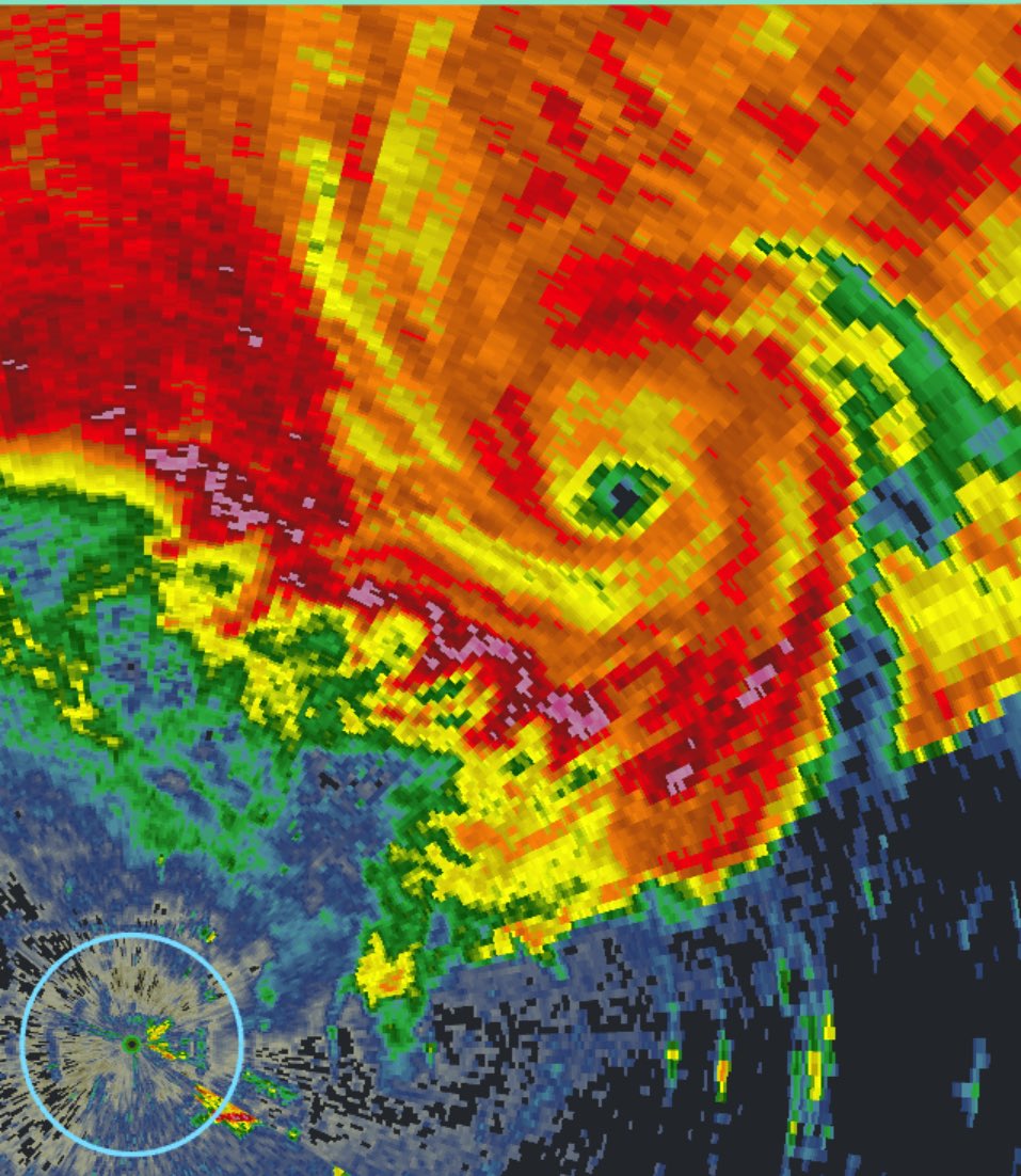
The wedge tornado that tracked through downtown St Louis on Friday has received a preliminary rating of EF3, with a width of 1 mile😳

Very hectic period ahead on the weather side of things, I would love it if all USA news settled down for a moment.
(I say, pleading to the void. :/)
Storm Chaser Scott Peake does it again with another incredible close range tornado intercept! This time it is the Blodgett, MO violent tornado crossed in from of him on I-55 North of Sikeston, MO. This was the first part, and the beginning, of the regional outbreak of tornadoes that went on throughout the night across the region.
Thank you to m...
As a storm chaser i can humbly say
-don't do this, he got extremely close and lost a window to it (and almost an arm or an eye imo)

(and I still wouldn't feel safe- mainly my eardrums. Both pressure change+ a very excited Reed.)
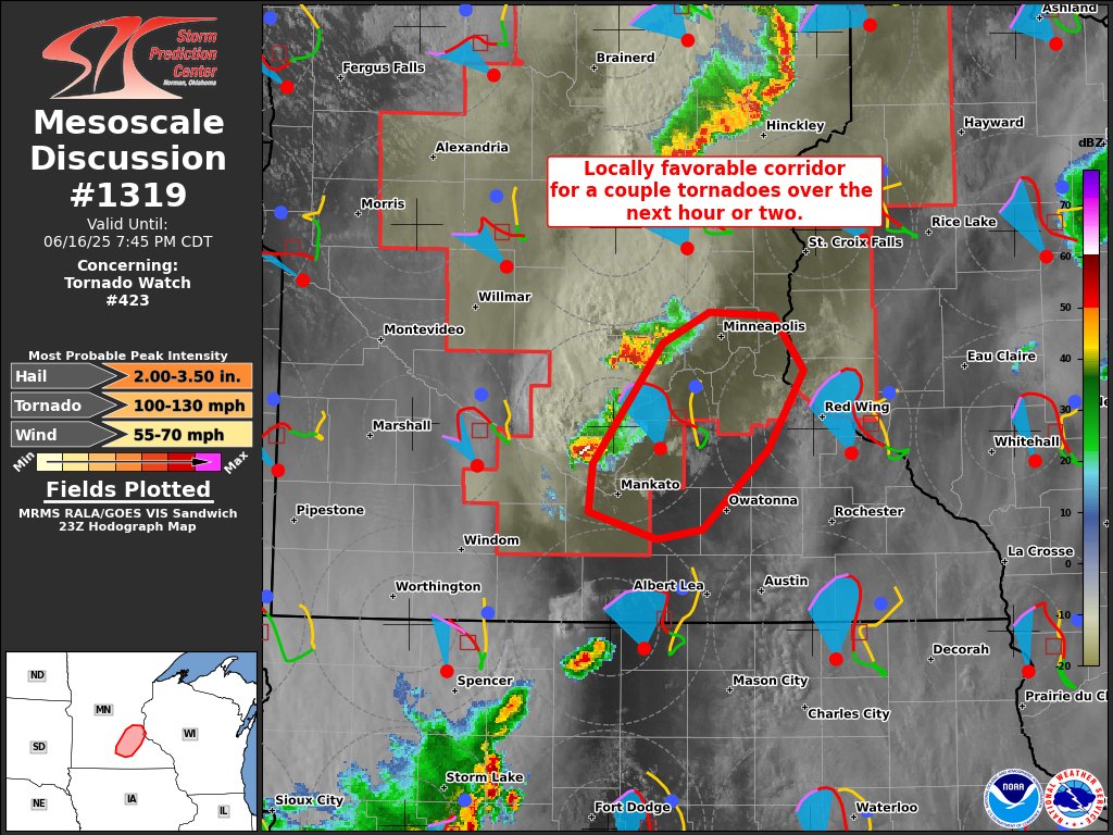
https://x.com/NWSSPC/status/1924086873900683404
(I'll give the exact split when the site updates, currently on the old forecast.)
7:55am CDT #SPC Day1 Outlook Moderate Risk: for southwest and central Kansas into far northwest Oklahoma https://t.co/TgJgC6cj9Y

Sorry about the delay! got tied up in somethin.


The tornado scar is registering even in geostationary imagery(IIRC the highest resolution visible channel is 500 m at nadir). https://weather.us/satellite/laurel/satellite-color-superhd-5min/20250517-1510z.html . There is a streak that wasn't there on the 11th.

Anyways, good luck to folks in the threat zone today.
Sorry about the silence, was catching up on some sleep- there's been a few strong tornadoes from what I can see in some chat backlogs, unsure if any populated areas were hit. (Edit- doesn't seem like it as of now, event is still ongoing)
But one of the tornadoes from today!

In other news i'm catching up on- Marion IL was given a preliminary rating of EF4 (190 MPH)


Grinnell, KS (population of around 300 people) at risk, decently strong rotation,

PDS issued for Grinnell, KS


Waiting on reports to see if the area was hit- couplet died out (along w/ CC starting to fade),
Tornado was active for around 5-10 minutes
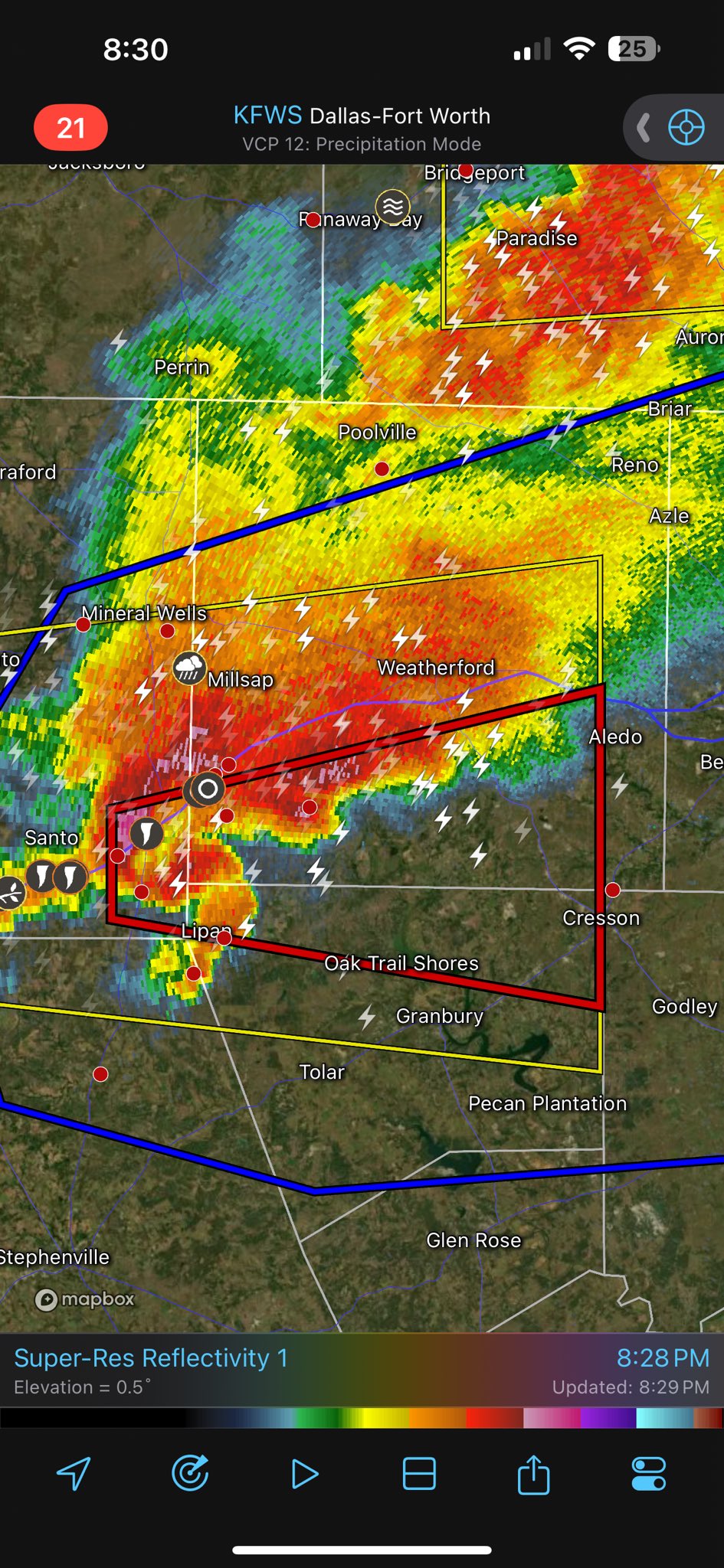
Down near Dallas, TX is also getting concerning


Southern KS, (Switching between Radarscope on my phone and GR2 on my PC for faster checks of 2 different areas instead of having to redownload the data every time.)

All current warnings- TOR- Tornado indicated, TORR- Tornado Reported
SVR- Severe TSTM warning, SVRC- Severe Considerable, SVRD-Severe Destructive
FFW- Flash Flooding Warning, FFWC- Considerable tag.
All times are in Zulu, which is the meteorological standard (especially for backend stuff like this)

/takes off mod hat
I really enjoy watching you cook @unborn timber - appareciate you sharing one of your passions and knowledge with the community
Daw, thanks, it's just one of those lil things that personally- i feel like more people should get into learning (atleast for their own gain)
Flipped Porsche on I-70 near Grinnell, KS. Occupants made it out. Tornado weakened on it’s way into town @NWSGoodland

Amazed this wasn't a fatality

The eye of the Arnett, OK tornado, captured by one of our UAVs as it collected scientific data on the environment within.
The OTUS project gets another amazing UAV intercept
that's wild
@BrianAllenWX Not fully confident, but this is the best match i've seen so far (39°07'29.9"N 100°37'58.5"W), Heart of Grinnell, KS.
**🔁 1 👁️ 4 **


@unborn timber DFW Texas area getting some action, figured to let you know


What server if I may ask?
several (Mix of personal+ OUTBRK+ TRX+Twitter.)
I am one of the rare examples of someone using geolocation skills in this field, there's very few of us!
This could be worst case scenario for the southern suburbs of Ft worth
:D, thank you
Twin Tornadoes! Interstate 20 and Hwy 281. Just East of Santo, TX. 25 minutes ago! @NWSFortWorth @TxStormChasers #tornado #txwx

https://fxtwitter.com/lverbeckwx/status/1924277425271149043
A man after my heart- perfect coords of where he's standing

Tornado on the ground, has grown since this video. My coordinates below. @NWSFortWorth
︀︀
︀︀32.57079° N, 98.18752° W
︀︀
︀︀East of Gordon TX on I-20
︀︀#txwx
First image taken near (39.1251259, -100.6341266)
︀︀110 Harrison Street, Grinnell, KS
Quoting Sekai Chandra (@Sekai_WX)
︀
The damage in Grinell, Kansas is really, really, really bad. Trees are debarked and homes are destroyed.
︀︀
︀︀Heartbreaking stuff.
︀︀
︀︀Source: www.facebook.com/share/1DyGzMRm2e/


Unreal footage of commercial vehicles being thrown from I-70 at Grainfield, Kansas. Video sent to me by Jennifer Mravich
Gordon, TX reports damage (waiting on images I can geolocate)
https://x.com/Naten86/status/1924281215378481231/photo/3


Heading up towards Greensburg*
Hopefully will pass south of Greensburg at 0236Z (like 20 minutes from now.)
Tornado active on this storm.

waow

Tornado Warning continues for Comanche County, KS, Kiowa County, KS until 9:45 PM CDT

Tornado is going much more north than the parent cell. Greensburg under a decent level of risk.


Tornado risk in the DFW area
Tornado Warning including Frisco TX, Allen TX and The Colony TX until 10:15 PM CDT

Just got warned

That'll try.

...christ.
likely a violent tornado S of Greensburg, KS

Tornado Emergency issued, Greensburg KS.

Insane radar scan.


maxed out VTP (Violent tornado parameter) 14.0
First responders in Greensburg evacuating town. (themselves)
Likely just missed Greensburg to the SE (around 2 miles!) Still a violent tornado tracking through KS, watching for any other towns in the path
closest point (PTDS shown, which is compiling reflectivity+ velocity+ corelation coefficient into a "how likely is this showing debris signature?")

white is 100% confidence (overlap of all 3.)
Storm chasers fleeing-"largest tornado i've ever seen"
Would your business like to become a sponsor of this stream, and put your brand in front of over 1 MILLION people who watch my content and support this channel? If so, please reach out via email for any sponsorship/business inquiries. My email address is [email protected].
Subscribe to comment during live streams! Feel free to do...

radar scans (not of surface level) recorded 210 MPH winds.
(Specifically calculated through gtg, long process i'm not gonna get into.)

▶ Play video
FxTwitter
·
Storm system is still concerning.

History doesn't repeat exactly-but it likes to rhyme- 5/4/2007, Greenburg was hit by a tornado that was rated EF5, just over 18 years ago.


Notable things- Denver CO spinup, OK/KS areas (Arnett, OK was also hit that day.)


Tornado Emergency including Sylvia KS, Plevna KS and Abbyville KS until 12:15 AM CDT


.... Bigger than the size of Plevna itself.


Tracking a massive wedge tornado with huge debris ball LIVE on my YouTube and @RadarOmega app

▶ Play video
FxTwitter
·

▶ Play video
FxTwitter
·
Homes destroyed on outskirts of Plevna, KS from strong tornado

"about 2 miles SW of Plevna"

If you’re anywhere near plevna and still chasing, terminate your chase and go help them. They’re gonna need it.
Before and after of this devastated home from the Plevna tornado tonight😳
Quoting Aaron Jayjack (@aaronjayjack)
︀
Homes destroyed on outskirts of Plevna, KS from strong tornado

https://fxtwitter.com/Acedog112/status/1924339807670378797
(The image originally posted wasn't even for the right town 😮💨 )

Having chased this, watched it on radar, etc., I have zero doubt in my mind this was an EF5-strength tornado with winds over 200 mph.
︀︀
︀︀I have never heard a roar like this in my career; I was within a mile at peak strength. It shot lighting out of it.
︀︀
︀︀Praying for Plevna.

oh boy we're doin it again tomorrow,

Risk spread, going to sleep so I can follow this event (which seems to be gearing up as another tornado outbreak)


Incredible snaky tornado up close near Arnett Oklahoma on May 18, 2025. This is one of several tornadoes spawned by this storm. I didn't see any damage to property and am assuming everyone in Arnett is Ok. Gotta get some rest. Big day tomorrow! Thanks everyone.


#Grinnell, #Kansas #Tornado Damage seen from drone - May 18, 2025. This tornado was one of many from a tornado #outbreak that occurred on the 18th. in Kansas and #Oklahoma.
All footage is Copyright Warren Faidley and cannot be copied or reproduced in any form without licensing from Mr. Faidley. See Mr. Faidley's homepage at stormchaser.com.
Mapped w/ the THREAT TO LIFE scale i'm experimenting w/
@unborn timber If you're watching the storms today I can livestream you video if you want gonna be smack dab in the highest risk zone


Honestly I was full eep for a good chunk of today (it finally caught up with me.)
the worst of it up north looks to be scooting just past me
TIL that on September 24th, 2001- Washington DC had one of it's most active tornadic events in modern history, including an F1 tornado that barely missed the White House itself


we talked to eyewitnesses to the London Kentucky tornado. they sheltered in the bathroom only to open the door and find out they didn't have a house anymore. in their backyard they found one of their neighbors with a severe leg injury.
you can contact us at
PO Box 134 Grays Knob KY 40829
email
[email protected]
Fair use is claimed ...
Good eyewitness accounts, skip to around 1:00 to get past the weird "in this video" intro

Insane #tornado violent winds spin the Dominator 3 a full 360 degrees with sensor launched inside by air cannon! Tornado emergency for Huntsville, Alabama. Dominator 3 disabled and now rolling. Ground-breaking science data set collected inside a powerful tornado
The Dominator 3 was hit by a subvort today, spinning the vehicle.
I think what’s crazy is if that was any vehicle other than DOM3 that would have possibly been a fatality incident.
I should note, the Dominator 3 weighs six and a half tons
There have been nearly 400 Tornado Warnings, and counting, across 22 US states over the past 5 days.
An insane run of severe weather.


Updated this to tidy things up+ add known fatalities.
Important note- the white arrows are estimating where bodies were recovered. Some of these are near structures they didn't live in (ex- SW most pin- actually came from the first house impacted/ W most.)
The only fatality that conflicted with my TTL scale is the furthest east one- debris induced fatality, killed w/in her own home., drone footage showed little to no signs of debris intrusion, so I assigned a fairly low value at the time.

..not including injuries until more concrete information is known (hopefully from the NWS assessment), but it should align w/ the above scale.
May also color code it somewhat to indicate degree of injury, (concussion would probably be on a different level than severed arm, both of those injury types have been documented on this one.), but that is an issue for future me.
I'm experimenting with this "personal scale" because I feel like it expresses how lethal tornadoes can be, hopefully better than a standard MPH estimation.
For example- a mobile home will be rolled and destroyed at EF1 or EF2 intensity- but would have a high chance of being fatal (and 3 deaths here are related to that.), but on the EF scale- is given one of the lowest indicators in terms of intensity.
Known fatalities relating to a damage indicator <EF3 (65-135 MPH)- 6 fatalities
Known fatalities relating to a damage indication ≥ EF3 (136-170 MPH in this case)- 2 fatalities [0 from the one EF4 damage indicator.]
Of course- there's still a lot to work to be done, as this tornado killed 19 total people, and I only have 8 mapped here.
🤬

This is where the most extreme damage occurred- it is still not on the damage assessment toolkit
Unusually delayed.

I kindof wonder if they're thinking of downgrading it (170 MPH EF4-> 165 MPH EF3), as this is the segment w/ the (from what i gathered) one structure that got the EF4 rating.
Construction typically isn't the best in this part of KY.
For context of how weird this is- Currently this tornado is rated EF4- w/ no damage indicators on it currently of EF4 intensity- despite NWS JacksonKY saying the EF4 rating was the final rating, on the 20th.

(This could also just be- "they forgot to check the QC checkbox for each of these items", that is also a possibility that happens sometimes, as it'll show up for them but not on the toolkit.)
^One of the most (scientifically speaking) bizarre injury types i've heard of in the modern era- two victims, each lost a portion of their arm, Male lost his left, female lost her right.
(I would wager this was debris induced, and something managed to pass between them at a high rate of speed- sheet metal? Would likely be too thin unless their arms were overlapped.)

This is legitimately the most amount of chasers I’ve ever seen for a nighttime chase. This is ridiculous.
︀︀
︀︀Chaser traffic is 1000x more dangerous than the storm itself.
jesus christ guys


Side bar for the weather community at the current moment- major chaser convergence, surprised there hasn't been a wreck yet.


Attached is Tornado Archive's records- filtered for all tornadoes w/ atleast 1 fatality.
The 2025 EF4 is not on here yet, and wont be until 2026 per this archive's procedures.
..I should also note- only the 4 tornadoes that entered Laurel County (around London KY) were included- you may see two F4 [pre 2007] tornadoes off to the left, yes one of them killed 36 people- but was over 50 miles away, I didn't include it.)


Floyd, NM tornado- likely decently strong.
.... There's actually a bit of a hotspot here, typically called "Clovis Magic", atleast one photogenic tornado in this area per year. (On average.)
Significant tornado in progress near Floyd, NM. More footage to come at higher resolution @NWSAlbuquerque

that's a beaut
Fresh satellite imagery from the last few days shows the massive scar across Daniel Boone National Forest from the EF4 tornado on May 16th, between Somerset and London, Kentucky as clear as day -

this fuckin SUCKED to find weirdly enough
37°03'39.16" N 84°19'19.33" W


Still needs to be fiddled with, not an exact 1-1 yet
Also got the Sunshine Hills area because why not since i'm torturing myself tonight.


oh my god imma have to fiddle with it again because it breaks in the web version
Some of the most extreme vegetation damage in recent history-
08APR25 to 16MAY25 (38 day difference.)


I would not doubt that if this area was built to a higher standard- or if this strayed north by about 2 miles- this could have easily shown evidence rivaling Joplin (2011) [And the death toll easily could have rivalled it too.]

Turning around near Rooks Rd over tornado damage that is nearly 1 mile wide. Flying over Sunshine Hills, London Corbin Airport, Levi Jackson Park, and The Oaks of London (Formerly Crooked Creek) #RMWservicesLLC Hughes 300 Model 269B Helicopter #N9361F
im gonna scream dude,


Left- published by GEO/ MIS last night, they want to charge you 5k+ a month
Right- my free project I started working on day of the tornado, again- $0.
I cannot have AI/ corps take my super obscure niche, like really?
Also they missed a trailer where a fatality was, I very much doubt they had people on the ground for this survey.
Why spend 5k a month when a Discord account and checking on this thread like once a day is free
$5k a month to get the data 2 weeks later-
I geolocated drone footage NIGHT OF the darn thing, Didn't even add satellite images until last night.
I believe a "get on my level" is appropriate here
Again, why spend 5k and waiting weeks when you can just be on this thread FOR F R E E and get stuff within 48 hours of things happening, oftentimes getting data night of
Lmao true
You guys think if I got a job with them and still published stuff here they'd get mad at me? Because 1- astonished this company exists,
2- why is it super expensive (i've contacted them before to inquire about price for satellite imagery, got told over the phone that "oh, yeah this is more for like big business or federal stuff, sounds cool though")
had a nice chat with that rep though about storm chasing. But this is one of those companies where you have to sign up for a call to be told how much it'll cost you. (and i was a naïve 17-18 year old holding a breadcrumb of hope it wouldn't be that bad)
You can easily go “yall slow as hell, and I’m doing this FOR FREE”
“And I’m getting stuff night of lol”
And here you are, doing this for the love of the damn game
For free
I looked closer and they're using blue for no damage i cannot believe my abysmal luck. (replied to my original post here with my Threat To Life scale, 17/MAY/2025.
It is quite literally my exact colorcoded scale. (blue->green->yellow->red) [I add on -->!!!, a modifier to red.]
NWS Jackson KY updated the tornado path, finally adding EF4 DI's... the moment I publish a new version of the project and planning to put it down for a while.

167 MPH EF4, 170 MPH EF4


Some of the most extreme tree damage I've seen in my lifetime, partially rivaling damage last seen in the 90's, before I was born. (for this level of tree coverage being obliterated.)

Tune into our 💯 hour Weather & Climate Livestream, brought to you by 200+ US meteorologists and climate scientists whose research is at risk due to proposed budget cuts.
Learn about the federally funded science that makes our weather forecasts and climate predictions possible! More at: https://wclivestream.com/

While we're bringing attention to stopping in the road, I wanted to bring this up for awareness. Please don't stop in the road, but if you do, really please do not do it on a blind hill. Not trying to shame this individual and don't know who it is. Just be aware not to do this.


Tornado in Georgia. Likely a very brief spin up, but it seems to have been surprisingly strong.
I have a forecast of partly funnel today
isolated funnels with a chance of a touchdown at about 50mph max

🌪️ CAUGHT ON CAMERA | Rachel Peters captured the moment a tornado in Henry County Georgia crossed I-75. Her husband Michael was driving. This was captured just after 3pm on 5/29/2025.

Looks like one house completely failed under what would be typically expected- (roof+ most upper walls intact, just.. crumpled.)
Another KY tornado (since lifted.)

Oh jeez, looks like it was surprisingly strong.- 1 fatal.

That is a very good photo. The clean foundation with the debris behind it, the flipped car and then the trucks in the background.
Also the cut-off trees and the empty space above them.
Certainly looks like debris-induced debarking on some of those too,
also guess what I got a hold of....

pink area is the satellite image initially included in the project. (still gotta fiddle with it a little as you can prolly tell.)
I am currently working on V4 of the Somerset-London damage path, and the start of it is a trainwreck.
Multiple damage indicators are either in the wrong spot entirely, (affecting the mapping)
or- are not showing what they are describing (ex- "Debarked trees"- image of a house, or the most baffling "Mobile Home SingleWide rolled"-
IMAGE OF AN RV CAMPER (This would be Other, closer to VEHICLE damage, not a built home!)
This segment needs to be redone, it might not even be the same tornado due to this misalignment.
This segment is of question- if continuous damage is found- then yes, same tornado, if not... there was another EF3 that day.

One of the stupidest things i've ever done, but it's new satellite imagery.

This will be V4
First image is showing how much I have left 🙃
discussion i'm crossposting here because why not.

given an EF2 prelim
OAX issues Tornado Warning [tornado: RADAR INDICATED, hail: 1.00 IN] for Antelope [NE] till 7:15 PM CDT https://mesonet.agron.iastate.edu/vtec/f/2025-O-NEW-KOAX-TO-W-0020_2025-06-02T23:37Z


Chance of severe weather (including a chance of tornadoes) in Europe on the 3rd and 4th per estofex, (https://www.estofex.org/)


My primary focus would be Germany on the 4th,

..or.. today i guess- missed this report.
DWD has issued an unusually strongly worded "Advance information" for tomorrow. Warning that the strongest thunderstorms could produce hurricane-force (120+ km/h) wind gusts and >8 cm hail. This could pose "a high damage potential to people & infrastructure." #Severewx #EUwx

Tornado Warning continues for Independence MO, Sugar Creek MO and Buckner MO until 3:00 PM CDT

Went over Arrowhead Stadium
Quick QLCS spinup in a majorly populated area (a lot of reports of semis being rolled over per KMBC 9 live broadcast.)

A TORNADO WATCH has been issued for the entire Kansas City area. WATCH LIVE:
huh.


Might have a surprisingly strong tornado near Edgington, IL


(suprisingly strong from this storm mode- QLCS spam hours, a lot of spinups in IL.)
Tornado Warning including Davenport IA, Moline IL and Rock Island IL until 7:45 PM CDT

Warning is a bit large because there's a 2nd circulation to the SE.

Checkmark is for the known active one, 2nd one is just starting up- may or may not be of concern going forwards.
....Hopefully they both absolutely murder eachother as they get closer. and don't produce tornadoes over the southern part of Davenport.
sounds like a likely outcome
Today has certainly oververified, (again- QLCS spinup spam.)
...But there was one sorta discrete cell that produced a tornado in/near Moore, OK today,
oh
I used to live there
I got out before The Big One some time ago though
the one in 1999
and I do mean that, it was the fastest F5 ever at the time
321mph over ground
38 mile track, 85 minute durations
just a pile of superlatives
Lotta concerning areas popping up along the front that will probably be watched very closely by the NWS.

Velocity is non existent at 8:16, at 8:19 it's got the look per reflectivity.
... Lotta bark, no bite on this specific segment so far. Still showing absolutely nothing on velocity.
But this type of storm system could quickly spin up a tornado within literal minutes if nudged right, so I really don't trust it.
I haven't seen anything about the canadian wildfires here yet, so: https://weather.gc.ca/firework/firework_anim_e.html
yeah some smoke from up north moved through the Plains yesterday
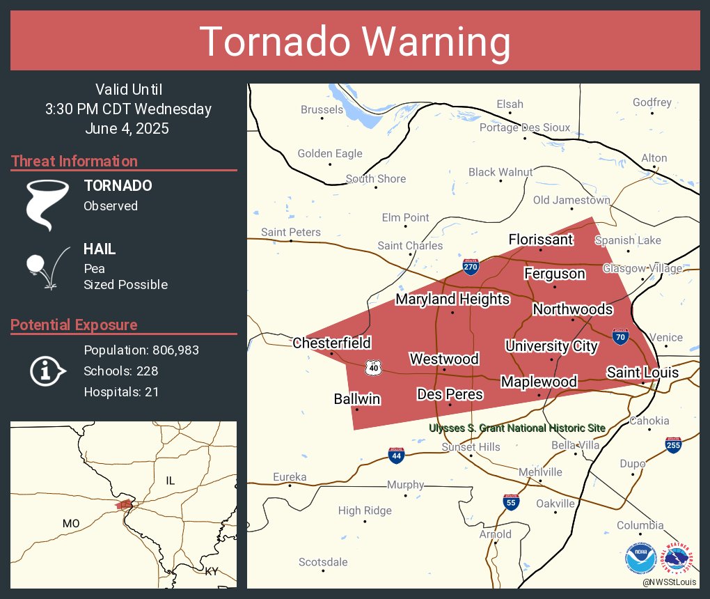
Tornado Warning continues for Saint Louis MO, Florissant MO and Chesterfield MO until 3:30 PM CDT
Tornado in St. Louis.
Lubbock, TX under a tornado warning- This supercell produced a likely strong/violent tornado in the middle of nowhere about an hour earlier, watching closely.

About an hour ago

▶ Play video
FxTwitter
·

So much hail it's showing up on CC as a pure blob, wouldn't wanna be outside in or around Lubbock as this nears.
Active

Storm chasers seeing dust being kicked up
... Might get a big one here, NW of Lubbock.

The cell's gone near stationary.
... Yeah this'll try to get strong quick.

"it's moving due south" -Brad Arnold (storm chaser)
"It's cut due EAST! now, Due EAST!" - Same chaser, now moving to escape.

Two different tornadoes reported under this mesocyclone.
Tornado Warning including Lubbock TX, Wolfforth TX and Shallowater TX until 8:45 PM CDT

... I'd argue the mesocyclone has practically lowered itself to the ground.. all of these tornadoes are acting more like satellites.
Two simultaneous tornadoes NW of Reese Center, TX. @NWSLubbock @TxStormChasers

Just documented multi vortex tornado from extremely close range just West of Lubbock! Storm is behaving similar to El Reno with large circulation and vorticies just sitting down chaotically. Be careful chasers!
Likely strong straight line winds going through Lubbock no matter what - one station to the NW recorded a 109MPH gust
Tornado reported in Western Lubbock, TX.
Edit- Waiting on damage reports, certainly a flash flooding issue ongoing.

Certainly straight line winds damage for the area, it'll be "fun" for the NWS to untangle if there was a tornado or not within city limits
This was technically a tornado (and of course technically a tornado is the best kind of tornado 😉)
https://www.rtvnoord.nl/natuur/1309445/windhoos-gezien-boven-ter-apel-grote-kans-op-meer-onstuimig-weer
In de omgeving van Ter Apel is donderdagavond een windhoos waargenomen. Die ontstond tijdens een onweersbui langs de N366 tussen Emmer-Compascuum en Ter Apel.


The embed is annoying. There's a video inside.
Definitely a funnel cloud though, acedog can put it more technically than me
prolly a tornado 👍 (video isn't loading on my end  )
)
east of Lubbock, TX- likely a strong 'un tryin to form,

..... No, you're not going crazy - another tornado warning W of Lubbock, TX.
.... With damaging straight line wind+ hail.


▶ Play video
FxTwitter
·
he was about to jump out of the truck lmao

whoof

FOUR HOURS AGO
but, possible tornado in Poland earlier today, waiting on damage reports
Decent little couplet for being on the edge of the radar's area, would be scanning extremely high up however.


A severe thunderstorm watch has been issued for parts of Oklahoma and Texas until 11 PM CDT

PDS TSTM watch (primarily for 4+ inch hail along with 105 MPH gusts likely)
Important note that if a tornado hits you on a storm that's already going 90+ mph, you don't need that much rotational speed to get significant damage, as it will be additive. (Depending on what part of the tornado hits you, same principle as hurricane quadrants, just vastly scaled down.)
(this is also vastly oversimplified of course- but it gets the point across.)
Not as intense as a tornado, but still

For non-Americans, potential of over 128km per hour winds
I am amused that "DVD size" is the actual agreed upon nomenclature for that hail size

Was there another object for that size before CDs were popular or have things gotten so bad that a once maximum "grapefruit" was not large enough?
you know, I don't know

I'd wager they just said "2 inch hail", "4 inch hail", etc, and moved to the analogy to get the point across about how big the hail is to the general public quicker
because I personally have no recollection of even hearing something similar while researching old events
that is some serious wind
Found an older version of the NWSI Directive that includes older nomenclature and an explanation for why they standardized the sizes:


This’ll be an eventful night for me, damn
Severe Thunderstorm Warning including Plano TX, McKinney TX and Frisco TX until 10:30 PM CDT. This destructive storm will contain wind gusts to 80 MPH!

Starting to hear thunder over here
FUCK
Power just cut for a moment
@unborn timber think you might like footage of someone personally experiencing the weather
footage warn: flashing lights and noise
..Strong tornado in NY (State, not city.)


There's like atleast one strong rogue tornado in NY per year ☕
Crossposting a discussion I had in a different server.

^Prelim rating of high end EF1 (110 MPH)
A more active thunderstorm pattern arrives Wednesday and Thursday (June 11-12) across portions of Nebraska and Iowa.
⛈️A Marginal Risk for severe weather is in effect due to the potential for hail and wind.
💧Localized heavy rainfall is also possible with the strongest storms. https://t.co/0dgUMq8qEP

It just hailed here in Madrid, here a pic I just took for reference

That's bigger than a golf ball, for those wondering...
We've been above 30 since the end of May (too early to be this hot, it feels like July), so to quench the heat we've been sent free ice for our cocktails
There's an amazing story about Ted Fujita when he worked at NWS Norman, Oklahoma, where during a notable tornado outbreak in like the 60/70's he and a few other meteorologists stood on the roof and just sorta watched, mix of helplessness and fascination, as this was a period in history where tornadoes were not as well understood.
One of the meteorologists noted that Ted picked up some hailstones at some point and was using it as ice cubes as he drank pure vodka
I think I heard that story 
Fujita's got a very interesting life, he got into studying wind-induced damage from surveying the aftermath of the atomic bombing of Nagasaki, and I would argue that if we didn't grab him as a scientist our understanding of tornadoes would probably be closer to late 70's early 80's understanding.
An unbelievably pivotal person in the field that I unfortunately will never get to meet.

Occurred on May 3, 2025 / Paris, France
"When life gives you ice."
Contact [email protected] to license this or any ViralHog video. ViralHog is based in Bozeman, Montana, USA.
Make money from your videos! Submit footage here: https://viralhog.com/submit
Subscribe, Like, or Follow ViralHog:
YouTube: https://www.youtube.com/viralhog
Faceb...
He also set up "Project NIMROD" which is like the best name ever.
https://en.wikipedia.org/wiki/Project_NIMROD
Project NIMROD (Northern Illinois Meteorological Research On Downburst) was a meteorological field study of severe thunderstorms and their damaging winds conducted by the National Center for Atmospheric Research (NCAR). It took place in the Greater Chicago area from May 15 to June 30, 1978. Data collected was from single cell thunderstorms as we...
cowboy meteorology
https://x.com/adamorgler/status/1933601780425748848
"Over 5,200 severe thunderstorm + tornado warnings issued by the NWS in May…
Only 9 of those were in Iowa."


'something something eye of the storm'

Tornado watch for MN, WI issued, probabilities included.

Tornado Warning continues for Crosby MN, Breezy Point MN and Aitkin MN until 5:30 PM CDT

welp.

▶ Play video
FxTwitter
·

The best 360 @insta360 reframe Timelapse known to man. Captures the full lifecycle of the Wallace/Wallfleet Nebraska tornado. 77 minutes of mind blowing footage condensed down to 1 minute. Streamed LIVE on the @RadarOmega app.
this was likely an extremely violent tornado that vibed in the middle of nowhere, Nebraska for about an hour yesterday. (Nearly stationary at times!)

(There are estimates that for this tornado to have condensed like this given the elevated cloud base, a pressure drop of around 150mb would be expected.)
in the middle of the middle of nowhere xP

around here
Specific area per the damage assessment toolkil, moved south.

note that this was rated high end EF2 (134 MPH), with multiple pointes effectively maxed out.
"Multiple small trees stripped of bark. Power poles missing."


yeah, weird that it just kinda parked there
also holy fuck lmao, my pin drop was just a guess
the one time I'm not playing Geoguessr
Hey, always a fun way to get geolocation exercises- find tornado video, locate where it is- usually you'll have an area/ town name to start with. (and you should be able to cross check w/ https://apps.dat.noaa.gov/stormdamage/damageviewer/ or https://tornadoarchive.com/ if you know the date.)
especially get into this if you're into trees, different types of trees get damaged at different rates so it can genuinely be helpful sometimes. https://x.com/NotChilledOut/status/1935091438892581071


Strong tornado in IL, W of Springfield.


Tornado+ zoomed out showing the storm in relation to the state.
LP supercell also producing one,

Circulating online, video credit to a Derek S.
Jacksonville, IL tornado. Very rapid movement.
A lot of little spinups aswell w/ this system
Likely another strong one W of Petersburg, IL.

https://www.facebook.com/217problems/videos/654333517637697 A local radio station had this sent to them,
"Champions Field in Jacksonville has been leveled" [sic]
Went straight through this garage, both sides still standing- middle segment collapsed. (Drillbits are scary.)


Given the location of this- it's part of the "Future Champions Sports Complex", looks to be related to the HS.
Closest footage that I know of- around the corner- facing the garage that got decked (albeit obscured by trees.)- likely went back inside just before it did significant damage to the structure

Yall not gonna believe this but apparently there was a tornado in Juneau, #Alaska back on Jun 16. Here's a video of it. Extreme rare for this part of the world.
#AKwx #severewx
📷: Romeo_Glacier (Reddit) Link below. https://t.co/D9jnCJhvNs
The hypothesis holds true still- next day was the Nebraska stationary tornado that easily was in the violent catagory
Let’s see if anything happens 3 or so days from now
New closest video dropped for the Jacksonville IL tornado- Filmer identified the tornado- and personally was a bit too bold afterwards

bro you are in the debris field pls stay in
fun fact- based on the plaps of skin on pavement- it really sounds like he's barefoot too, which is.. yeah
I'm from put-out-lawnchair country and that was pretty dumb


Monster tornado moments ago. Ow wrapped in rain NE of Jamestown, ND was getting stronger and bigger when it got wrapped @NWSBismarck . Streamed LiVe on the @RadarOmega app


110+ wind gusts on the linear part of this storm btw
verrry strong derecho.
You probably aren't going to see a radar presentation of something like this again for a few years


PDS issued.
That's a real strong one going into/ near Sheldon, ND.


Getting dangerously close to Fargo.


954.2mb of pressure was measured by TornadoPaigeyy and Bryce Shelton in Mayville, ND, within our wake low. This is comparable to a category 3 hurricane, and is also producing 110+ MPH winds!
All hallmarks of a violent tornado near Sheldon/Enderlin, North Dakota last night. This is the property where two people sadly passed away. Trees debarked, house swept away with very little large debris left in the vicinity. Photos via @brianemfinger - www.facebook.com/story.php?story_fbid=1019223680197126&id=100063285096876&mibextid=wwXIfr&rdid=tGxVBv9xz0OJflUR


Significant damage and aftermath from the strong tornado yesterday east northeast of Jamestown, ND. #NDwx @NWSBismarck @NWSGrandForks

Strugglin to ID what image #1 came from here, #3 looks to be part of an irrigation pivot..?
Certainly a strong if not violent tornado w/in this outbreak (most of them were QLCS spinups that lasted <10 minutes.)
The pin doesn't seem to match the terrain in the photos, and the radio tower visible in #3 doesn't appear on the horizon anywhere near there. Is there a reliable map of the tornado's path?
Wont be for a few days
Some people have made radar estimates using the associated velocity couplet as a rough approximation of where it was- but due to how far it was from the radar source it wont be the best.'
Yellow pins mark farmsteads that may have been impacted, while the two red pins represent confirmed hit farmsteads.
The one near the 106.5 kt VROT is completely gone, someone I know is currently there. Brandon Copic is at the northern one, also gone. Absolutely devastating.

(I personally don't like Nick but he is a pivitol figure in opensourcing this sort of stuff, no idea where he got the 106.5kt VROT reading from, radar wasn't exactly scanning the best at that time so it probably shouldn't even be used as a rotational approximation.)
Not seeing irrigation systems near Jamestown, but looking at the original photos from Twitter the first photo appears to be the rear axle of an older wagon. Specifically the older-style suspension. It's very likely part of the pile of things from the third photo which looks like an undercarriage of something that's seen better days. Note that the tire visible in #3 looks similar to the outer tire on the right of #1.
We have 3 teams surveying damage from last night's storms. Preliminary tornado ratings based on damage:
West of Valley City: EF-3+
South of Valley City: EF-2+
Enderlin area: EF-3+
Bemidji area: no update
These ratings are PRELIMINARY and subject to change.
#mnwx #ndwx
Would be the first ND EF3+ tornado in over a decade if my memory ain't failing me
(totally didn't forget the state for a moment there.)
that's the hindquarters of a very old truck in #1
and I think you called it right for #3

WSB-TV Channel 2 - Atlanta
Malachi Chaney was severely injured when a tornado directly hit his home last month.
holy fuck
The house this kid+ his father- actor Tray Chaney- was completely destroyed, major construction issue allowed for it to practically be shoved off the foundation
jesus


Road buckles a second before this car hits sending car in the air. #mowx #weather #heatwave #what #wxtwitter
(Ignore my ping the tornado actually wasn't added, mixed up the tornado you were asking for a map of and a different tornado that tracked similarly FAR to the NW, near Jamestown ND instead of Sheldon, ND.)

A Heat Advisory is in effect across the area through Wednesday. Most locations will have heat indices peak around 105 both today and Wednesday. #kywx #ekywx

everything's perfectly fine in KY rn 🫠
monsoon season here in the plains
There's a decent chance of a tornado today in SE Minnesota.
If you're in NE Georgia/ NW South Carolina- you really gotta worry about wind in general.


Someone's gonna get smoked by an 80 MPH downburst today in the midst of people who get 60-ish (heatwave conditions are sorta concerning for straight-line wind events.)
mmyep
one weird thing is we're getting a proliferation of funnels out here
not strong enough to be classified but can spin up to 50mph+ if they touch down


ope
Just got tornado warned, This one spun up quick (At 6, nothing to worry about, at 6:15- that is a fully developed hook echo and an active tornado what)
It's a STRONG one too!


I would be amazed if there's no damage in or directly around Yucatan.
I'd wonder if the geography of the area played a part in the speed. It's the Drifltess Area with reasonably sized hills and wide valleys.
(probably to an extent, storm merger behind it certainly helped too, pushed the hook echo into it's inflow, increasing rotation.)
Tornado has since stopped showing any signs it's still actively doing damage, may have been a fairly brief-but still fairly strong- tornado
Another area i'm watching near Nodine (NW of LaCrosse.)


And it's producing another tornado 🫠


The main "scary cell" went observed again, S of Hokah, MN.


Is one active? Probably? It's hard to tell right now due to how close it is to the radar.

And Florida still finds a way to completely baffle me
how did this do this it's UPSIDE DOWN

I have no clue how in the world this one even happened- likely insanely weak, but what

@NWSTwinCities I just followed a tornado approximately between these two points. It was on the ground for most of that stretch. Strongest early on with debris in the air

what
https://www.facebook.com/lillie.briahna/videos/1457952238699412
Hartland, MN
still standing true to the old saying that no matter how much you chase
no matter how long you stick your nose in forecast models
some random $^@!& dude in a pickup truck will have the view of the year.
damn that is prime real estate right there
The only row of seats closer then that needs that tornado car to be inside

Incredible video from Ranchero Village of the storm moving through tonight. Look at it just lift that mobile home! 📸 Lori Gill
bafflement continues.
picked up a mobile home, sweeped some debris under it- lowered the darn house back onto it
i spent so much time looking for that darn "V shape", didn't even account for a potential carport.
I am ungodly upset at how long this took me to find.

According to witness statements+ a gofundme, the homeowner survived, was "beat up pretty bad"

(Source of image+ information)
https://www.gofundme.com/f/rebuild-moms-life-after-tornado-disaster

I am down and out for the foreseeable future, house got hit directly by lightning.
So much shit got fried (or is suspected to be fried.)
My computer - probably my driver corrupted in some way
Router- also down and out, not connecting despite being hardwired
Stepfather's room (seemingly took the brunt)- 4 monitors, a TV, and his graphic's card all fucked
My mom's setup - one USB connection (which is needed for a key card) is not working.
Speedy recovery m8
In the long term everything should be aight, just real damn annoying
Super loud bang+ sparks
Sparks was when I knew something got utterly fucked.
Geeez, that's awful. I hope your luck turns, fellow worker

NOTUS
“I've never seen anything like this,” a former NOAA administrator said of the surprise announcement.
WE ARE BACK BABY
Update on this- the adapter fried itself, cord+ monitor was safe! (Currently in a jank PC->adapter->adapter-> monitor workaround right now but it is working)
Router was... not recoverable, got a new one in now 
Stepfather's gear- everything is seemingly fine except that graphics card, just can't support all of the monitors w/ integrated graphics


Can confirm, Minneapolis had some wild weather. Still waiting on wind/tornado confirmations but the vibe is on alert.
https://fxtwitter.com/ChasingWConnor/status/1939169823813984673/video/1
Edit- Better video, switched embeds.:
https://fxtwitter.com/paigevincent09/status/1939141082710999173

▶ Play video
FxTwitter
·
Better video- this is also the first time i've ever seen something like this- but I have a hunch what happened.
it resembles a vortex breakdown, but it didn't actually die- like it wavered on the conditions required to be tornadic vs dying out
https://x.com/Brick_Suit/status/1939206826429686070/photo/1
also this happened


More into vortex breakdowns- this is harder to see because it's a scale model- but watch the bottom of what would be the condensation funnel- it "jitters" back in forth as the parent circulation starts rotating in a similar way- usually this would occur closer to the end of a tornado's life
Some researchers are calling this "Vortex Shedding" already, but I feel like it's roughly the same principal we already sorta understand, it just didn't happen fully
Notably- a lot of known instances of a failed vortex breakdown occurred on fairly strong tornadoes, (with the more significant damage being just after it gets it's "2nd chance at life")
Certainly something people much smarter than me are currently dedicating years of their academic lives to.
Fascinating
https://www.youtube.com/watch?v=mDPg9vJ_eJE
https://www.youtube.com/watch?v=QhEcQUA4C78
https://www.youtube.com/watch?v=MQB7nq-qtkY
https://www.youtube.com/watch?v=iFNE68xlf04 (This one catches the start of the vortex breakdown at around 2 minutes in, before the big one at 4 minutes in.) Also shows SAR efforts after a house was struck- 0 fatal, several injured
Full videos, (Only the first one will be embedded,)
On the evening of June 28th, 2025, a supercell developed near Watertown, South Dakota. Within 2 hours of its lifecycle, it had become tornadic, producing its first substantial tornado (and a brief second) near the town of Clear Lake(first 11 minutes of video). A second, more violent tornado formed on a cell behind the initial storm, producing de...
That last video there is probably the best at showing how violent it was after the (TWO!) failed vortex breakdowns
Incredible aerial imagery of the Gary/Clear Lake, South Dakota tornado yesterday evening. Source: Shawn Cable on Facebook, via this link - www.facebook.com/100044186721509/posts/1277721373710741/?mibextid=wwXIfr&rdid=7cRCvgtR9o21qPmM #SDwx

From Image #1- not the type of damage you want to see, amazed that 4(+?) people survived here.

Usually it’s just “a massive ditch being dug from tornado” right?
Still interesting seeing the swirls
yeah usually not a soft touch
The official NOAA "budget request" to Congress (which is a detailed version of the "President's Budget" would be devastating, and basically end all research and development.
︀︀
︀︀Purportedly, the proposal moves a lot of weather research and development under NWS, but doing so while eliminating the labs themselves and the CIs would get rid of most of the people and infrastructure that does this critical work.
︀︀
︀︀Fortunately, Congress has the final say on this, so I recommend pressuring your Senators and representatives to step in and continue allocating NOAA the resources to pursue life-saving research.

What if the bill somehow fails?
Rare setup in NE China especially Central Heilongjiang Province tomorrow. Tight, negative-tilt trough coupled with ample moisture and sufficient CAPE, all hazards possible including some tors even significant ones.

2:55 PM EDT 7/1/25: A Special Weather Statement for potential funnel clouds has been issued for parts of NW and north-central OH:
︀︀
︀︀mesonet.agron.iastate.edu/wx/afos/p.php?pil=SPSCLE&e=202507011838

this is effectively the tamest tornado watch i've ever seen.
NWS generally doesn't issue tornado watches/warnings for funnels
How do funnel clouds form? And, why would we bring that up today? Well, conditions may become favorable for funnel cloud formation this afternoon across portions of southeast NE and southwest IA. However, we don't expect any to develop into a tornado.

chance of spinny bois

Major damage and people injuries in Cangzhou, Hebei Province today, a significant tornado passed an industrial area, demolished most of the warehouses and tossed cars.


Additional photo showing damage from this tornado,
that's three football fields for the Americans
it is very funny that a good chunk of weather nerds just have most measurement conversions memorized (or have a "it'll be rouughly X degrees Fahrenheit" equivalent)
Around 23 girls missing from children's camp in Texas after catastrophic flooding
(from press conference)
6 fatalities already reported
(Upped to 13 per KHOU 11)


Serious flooding in Texas Hill Country in Kerrville and Comfort, TX. This home is swept downriver with people inside. Pray for Texas.🙏
There's also an earthquake swarm hitting the Ryuku Islands in Japan,

Some residents have evacuated, fearing either a much stronger quake or volcanic activity, strongest quake of the bunch was a M5.5 from what I can tell
(imo i'd lean more towards the volcanic side of things rather than superquake side, shouldn't really be much of an issue hopefully.)
Best source for Japan earthquakes is JQuake as usual, https://www.youtube.com/watch?v=TM97DTdD0Yk- English version of their livestream
..this also isn't helping this story that's currently ongoing (Just a funny little coincidence that affects international travel, fun times.)
https://time.com/7300133/japan-manga-earthquake-panic/

TIME
Earthquakes can’t be predicted. But a manga artist’s dream of a July 5 'megaquake' has spooked some residents and travelers.
@moyavila #BREAKING Death toll from Texas floods rises to 32, including 14 children: sheriff


▶ Play video
 FxTwitter
·
FxTwitter
·
From the start to the highest point in this clip in about 15 minutes.
Saw this on Bluesky and hopefully it's a reasonable analysis of the factors that went into the flooding:
https://bsky.app/profile/pppapin.bsky.social/post/3ltaqypn6rk2w

It's been a bit since I've done a meteorological deep dive, but the devastating flash #flood in central Texas this July 4th/5th deserve a closer look. #TXwx
Yes remnants of #Barry were involved helping enhance moisture. A remnant MCV from Mexico on 3 July also played a role.
Full evolution below ⤵️
the road closed signs did a great job of holding the line

Eleven girls from a summer camp along the Guadalupe River in the Texas Hill Country are among those unaccounted for. Forecasters warned of more rain and possible flash flooding in hard-hit areas on Sunday.
Excessive Rainfall outlook for today and tomorrow.


The mainstream media is deliberately lying about the events leading up to the catastrophic flooding in Texas.
︀︀
︀︀The National Weather Service executed timely, precise forecasting and warnings, despite unprecedented rainfall overwhelming the region.
︀︀
︀︀Here is the timeline of NWS’s proactive response:
👀
Would like to note that Texas itself sorta started this but, close enough... please don't use this as a wrench to bludgen CNN with somehow.
Timeline for flood in Texas
https://www.npr.org/2025/07/05/nx-s1-5457759/texas-floods-timeline

NPR
NPR has compiled a timeline of when local, state and federal officials posted warnings on social media as well as the timeline of events as presented by local officials.
Haw River at 21ft. Rose by 5 ft the last hour. Flood Emergency incoming???

North Carolina flooding
another fire season in California
https://calmatters.org/california-wildfire-map-tracker/
Map of active wildfires burning across California. Explore wildfire history and when fire season starts in California.
Surreal geolocation: https://maps.app.goo.gl/pLQUXNYGMGBXjdVQ7
https://www.wboy.com/emergencies/fathers-day-flood-west-virginia-2025/apartment-collapse-in-fairmont-leaves-residents-stranded/

Street View · Google Maps
Explore a place in a more immersive way in Google Maps.
Also a crazy place to put a large apartment building. Basically right at the head of a wash/gulley where a creek starts, with a long asphalt slide (the road) to divert water into a depressed parking lot.

Telegram
🟠Lattakia fires..flames reach Farnaq Reserve
🔵Massive fires are spreading to new locations in the Lattakia countryside, amid difficult terrain and strong winds. No civilian casualties have been reported, and efforts to extinguish the flames continue.
🌐More
🔔HAWAR NEWS AGENCY #ANHA
🦋Our position in Blue Sky https://short-link...
*Vandal/conspiracy theorists TARGETING RADARS*
︀︀*Criminal knocks Oklahoma weather radar offline*
︀︀
︀︀OKLAHOMA CITY – A vandal knocked News9's weather radar offline for a time Sunday night. The suspect arrived at 9:34 p.m.
︀︀
︀︀Griffin Media, which owns the radar, wrote that the man disabled a "key power connector, smashed the power meter and broke into the generator's transfer switch control panel before destroying it.
︀︀
︀︀They're urging anyone with information not contact OKC Crime Stoppers. He's accused of sabotaging "critical weather-prediction equipment."
︀︀
︀︀This comes as a growing number of conspiracy theorists and misinformed and/or uneducated members of the public adopt outlandish ideas that radars "control" the weather.
︀︀
︀︀The National Weather Service, meanwhile, has received credible threats of violence from a specific group called “Veterans on Patrol.”
︀︀
︀︀According to The Washington Post, a Te…

Vandal briefly knocks out a private radar for News9 (Local station.)
Also talks about the threats the NWS has recieved recently.
I really hope this won’t be a trend at all
Wait... Veterans on Patrol sounds familiar.
Oh, right, these guys: #far-right-monitoring message
https://www.gettyimages.com/detail/news-photo/large-tree-is-uprooted-outside-of-a-home-near-camp-mystic-news-photo/2223038674
Per Getty Images

..That's on a house- you can see a toilet left of center, really puts into context the degree of damage associated w/ these floods in TX.
Ohh dat's a big stick
https://www.intellinews.com/southern-ocean-current-reverses-for-first-time-signalling-risk-of-climate-system-collapse-389540/
(archived https://archive.ph/d2Rnq)

A major ocean current in the Southern Hemisphere has reversed direction for the first time in recorded history, in what climatologists are calling a ...
https://apnews.com/article/trump-lutnick-weather-service-privatization-conflicts-9892de853c283468e6fb970cfd898d96
(archived https://archive.ph/7uxes)

AP News
Downsizing at the National Weather Service appears to be part of an effort by Republicans to privatize such agencies.

An “anti-government militia” called ‘Veterans on Patrol’ told News 9 on Tuesday that it is “targeting” Oklahoma weather radars, days after an individual vandalized News 9’s weather radar.
I really hope more stuff like this won’t happen…

Bit of an aside but the weather side of twitter has been swarmed with people believing that HAARP, radar sites, whatever is geoengineered warfare against the American people and it is maddening.
It is a very notable uptick lately.
(Lately being over the span of the last 2-4 years. They used to stay in their bubble but now it seems bizarrely organized to go after meteorologists online.)
Y’all, when it rains a lot, it floods. It’s always been that way.
︀︀
︀︀Flooding has existed as long as rain has. It can destroy homes, wreck communities, and take lives.
︀︀
︀︀That’s why we’ve built warning systems. That’s why I do what I do.
︀︀
︀︀But lately, there’s a rise in conspiracy theories about “weather modification” and “government floods.”
︀︀
︀︀These claims aren’t just false, they’re dangerous. They distract people from real preparedness and get in the way of saving lives.
︀︀
︀︀Please check your sources. You’re being misled by folks who don’t understand meteorology, or worse, don’t care.
Go to these comments and scroll, there's a SURPRISINGLY HIGH NUMBER of people believing the claim Ryan is trying to dispute.
also- pain lol, little bit of a wind event for the NE (Including a tornado warning that went over D.C itself,)
I have a hunch 1-2 tornadoes occurred (primarily in Delaware.), but none are officially confirmed.

*Camp Mystic girls were FOUR MINUTES from safety*
*Camp was negligent in not evacuating students*
*Warnings came HOURS ahead of flood wave*
Extremely uncomfortable details have emerged regarding the 27 flood deaths at Camp Mystic in Hunt, Texas. @MatthewCappucci reviewed

long post.
Personally- the camp directors probably didn't have a way to receive warnings, which I would argue is negligent in the notably active flood plains down in TX.
Updated death toll is at 120 from this event, most of which (80%!!) came from this one county (96)
Of those 96 (currently) confirmed fatalities in Kerr County, 27 came from this one camp. (around 22% of this event's total fatalities)
It's easy to look at "what ifs" after the disaster, but...
https://midlandusa.com/collections/weather/products/wr-120-weather-radio
Fifty bucks.
An IF2 tornado has been confirmed near the town of Parkano, Finland in the Pirkanmaa region from severe weather on July 3rd. Remarkably, this tornado occurred near a radar, and even had a tornadic debris signature! This is the strongest tornado in Finland since August 20, 2004.

Finland tornado from July 3rd verified (IF2!)
Active tornado NW of Davenport
Might be tracking into the northern part of the city.

An area SW of Madison, WI has my eye atm,

Isolated little cell that might get overtaken by the line- pure pattern recognition on this front- sometimes goes real tornadic if it hits it right.
(Update many hours later because i forgor to at the time- unded up being shoved up to the north and fizzled out before it even got to merge with the main QLCS.)
Closer zoom on this area- very weak rotation currently, but it is there,

Flash Flood Emergency continues for Davenport IA, Moline IL and Rock Island IL until 9:00 PM CDT

Davenport IA has moved from a tornadic threat to an immediate flooding threat.

@ryanhallyall northern Davenport, IA next to McDonald’s and happy joes on welcome way.

An analysis of flood maps shows that several buildings, including those where children were sleeping, were in known hazard zones. A $5 million expansion in 2019 did nothing to alleviate the problem.
Just in: Aerial damage assessment photos of the July 4 Texas Hill Country flooding are now available online.
More imagery will be added as flights by NOAA's Twin Otter plane continue.
Go to: https://t.co/CjNtsV9jf2
Would appreciate screenshots, it isn't loading for me
It got reposted w/ slightly different wording
Revised thread breaking down events:
︀︀
︀︀*Camp Mystic campers were minutes from safety*
︀︀*Warnings issued hours ahead of flood wave*
︀︀*Importance of having severe weather/emergency plans*
︀︀
︀︀Details have emerged regarding the 27 flood deaths at Camp Mystic in Hunt, Texas. It appears the campers were within walking distance of safety had flood plans been exercised by administrators.
︀︀
︀︀Despite having hours’ worth of notice, it’s unclear if or when administrators made the decision to vertically evacuate campers.
︀︀
︀︀The National Weather Service issued a “considerable flash flood warning” at 1:14 a.m. This triggered a special WEA, or wireless emergency alert, that activated cell phones. This would have woken camp leaders up for those with adequate cell coverage, which is spotty at best in Texas Hill Country. In the event of poor cell service, the camp could also have opted to have a NOAA weather radio present. Weat…

Ty!
A MODERATE risk is in effect in our Day 1 Excessive Rainfall Outlook. More details: https://t.co/FQU5sblUHQ

Chance that area floods again.
That places soil is already saturated to begin with
Ongoing NWS Storm Damage Survey has determined that at least EF2 tornado damage occurred in far southwest Davenport on Friday around 5 PM. The strongest damage occurred at a dealership. Several RVs were flipped or turned. A 25,000 lb motorhome was flipped on its side. #iawx
oh how i love manually sorting through 500+ damage indicators
...should have the Somerset-London project completed soon ™
will be v4.
I may also look into actually writing a script and recording a video, ala BobbyBroccoli's style. (maybe. depends if i want to stack another thing onto this messy tower I call a schedule.)
pain.


One of the more baffling points i've looked into so far,
Rated 150 MPH EF3... I.. really don't agree with this, likely failed at a much lower intensity. (note the lack of catastrophic damage to nearby structures)
(Measurement is to that beige shed, only 50 feet away.)


What likely happened is that wind was able to get under this patio (which completely surrounds the house, and does not try at all to deflect wind), and practically lifted it like a kite.

so much dumb note taking needed to figure out what in the who in the what in the how
There's 9 houses "rated" for this stretch of 7
2 houses got double counted. (this 140 MPH DI for "two houses" in a darn field should probably be removed. It is the source of the double count.)

House to the top (150 ???) was rolled across the street.
The (i'm assuming initial) surveyor assumed there was a house there that just collapsed straight down, then looked across the field- saw the house w/ ext. wall damage,
Jotted both down in one damage indicator (which is another no-no.), then stick his DI marker in a field (another no-no.)
Instead of removing this during QC- they tacked on a "Update- on further review, 'this house' (didn't say which of their 7 images) was from across the street"
This took about 40 minutes for me to figure out what happened during this process.
It's always uncanny when you're able to line it up 1-1, down to the same exact car being at the same spot. (Car likely got slightly pushed down the hill either just before or during the 2nd FL collapse, which crushed it.)
This was an EF2 damage indicator. (122 MPH.), no known fatalities at this location.


tl;dr- prolly delayed.

This might make a return, might finally test it on something. (Might aswell while redoing a section of it anyways.)

Globalquake has upped it's estimate to M7.2, (It is likely lower than that a tad bit.)
Edit- USGS has it at M6.7
https://earthquake.usgs.gov/earthquakes/eventpage/us7000qcik/executive
No tsunami expected w/ this one
Flooding in NYC and NJ

Threads
This is tonight in NYC. Just a little flash flooding... 😵💫

Threads
BREAKING! We are reporting from Scotch Plains, New Jersey where major flooding has occurred with heavy rainfall! This is unbelievable. Water rescues ongoing!
#newjersey #flood #rain #flashflood #water

Severe storms prompted flash flood warnings across the New York City area on Monday night.


CANCELLATION: M7.3 055mi S Sand Point, Alaska 1238AKDT Jul 16: Check with local officials for all clear
Information on the fire-induced tornado at the Deer Creek Wildfire in Utah 7/12/2025. #utwx
https://t.co/3pzGTd57Kw

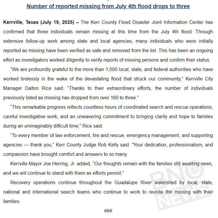
A bit of good news after the devastating floods in Texas:
More than 100 people previously reported as missing have been confirmed safe. Only 3 people are still missing.

had a M5.9 (estimated) foreshock
This is likely somewhat lower (Pure lack of stations in this area!)
Edit- Actually slightly higher- M7.5 per USGS

A tsunami watch has been issued for Hawaii, they're watching it closely.
Another strong one, My program's chucked it at M6.5-ish, 3rd M5.0+ one within 20 minutes
7 earthquakes recorded as of now, all M5.0+ per USGS

(I am so sorry that the one time y'all mention me in server discussion, there's absolutely no weather to talk about. I'm still here I promise.)

Smithsonian Magazine
A clip recorded in Myanmar in March reveals a curved path of the fault slip, which can help scientists better understand the physics of such events
🌩 Een zware hagelbui trof donderdag het dorp Les Bois, in de Jura (Zwitserland). Lokaal viel een laag ijs van tientallen centimeters dik! Vrijdagochtend was de hagel vanuit het vliegtuig nog steeds zichtbaar... ronduit bijzonder beeld!
Credits Tom Rufer (via SrfMeteo) 👇🏻

Translation:
"🌩 A severe hailstorm hit the village of Les Bois in the Jura (Switzerland) on Thursday. Locally, a layer of ice several dozen centimeters thick fell! On Friday morning, the hail was still visible from the airplane... an utterly remarkable sight!
Credits Tom Rufer (via SrfMeteo) 👇🏻"
That's a beautiful photo. The localization there will make for some wild stories comparing the event with the neighbors.

While the weather down here was pretty calm, it was a little different in the thumb area. The first part of this video is a tornado which was videoed by Lieutenant Doug Confer of the Deckerville Fire Department.
︀︀
︀︀The ending is the path on the ground captured by MSP Aviation.
︀︀
︀︀Just another reason why it is important to take shelter when a tornado warning is issued.
..i missed the very brief tornado that occurred in Michigan today.
There was also one in Ontario,
https://fxtwitter.com/IWeatherON/status/1949267525151154271

Not getting any major reports of damage, pure "ooga booga look at the spinni cloud" side of things, but the weather has been so tame lately that the weather side of twitter is eating this up.
speaking of that however, i do have my eyes on the 29th, might have a bit of a wind threat for the area, might see a Slight/ Enhanced risk pop out here.


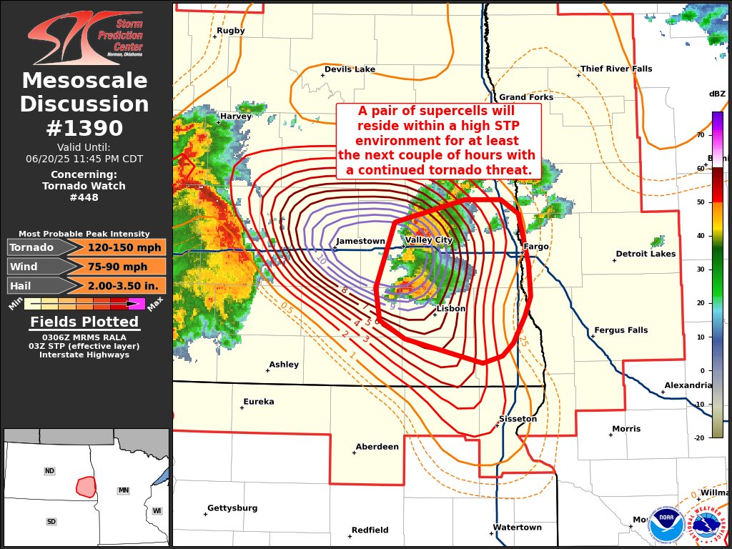
Keeping an eye on this segment as it approaches Grand Forks,


Just a segment getting a kink, might produce a quick spin up, my eyes are on the southern side of the warning, but any part of that segment could quickly produce one.
... Not expecting anything of real note per say, unless it gets tornadic just as it happens to be over a town.
..might have some straight-line wind induced powerline damage (eg- branches hitting powerlines) in Grand Forks,
https://x.com/elanazriel/status/1949378072769077398
Sign of straight-line wind damage at the least, likely stopped being tornadic before it crossed over town,
A tree and several large branches down on University Ave near University Park in Grand Forks. @NWSGrandForks #NDwx


▶ Play video
FxTwitter
·
Tornado Northwest of Henry South Dakota hit a home. We immediately did search and rescue, but could not find anyone. Praying that they just weren’t home at the time. #SouthDakota #sdwx

Keeping an eye on that cell that'll track over Minneapolis

This is ACTUAL footage of a tornado today. This was captured by Brandon Copic with WeatherWise.
︀︀
︀︀This is not my video, please support Brandon Copic on YouTube, and X/Twitter.
︀︀
︀︀📍Watertown, SD, USA
︀︀
︀︀#wxtwitter #wxX #SDwx #weather #tornado

2:54am CDT #SPC Public Severe Weather Outlook #PWO concerning #mnwx #sdwx https://t.co/712fgkU3no

5% TOR, 45%# WIND, 15% HAIL

I didn't think we'd get a MDT tbf
I am seeing some news sites saying "some areas could see 'hurricane force winds' " which.. yes, 75 MPH would be equivelant to a weak Category 1, but eh... i really don't like that analogy personally..
(There is good potential some areas see upwards to 95-100 MPH gusts.)
Expanded the MDT risk area, wording now says 75-90 MPH appears likely.


A lot of mergers behind the hook echo. This will likely continue for a long time and may get real strong.

A severe thunderstorm watch has been issued for parts of Minnesota until 1 AM CDT

The broken line of storms continues to develop across parts of W MN, producing winds up to 60 mph and hail up to nickel size. Storms will continue to move southeast this evening, reaching a line stretching from Mankato up to the Twin Cities metro around 9-10pm. #mnwx #wiwx

Over 100,000 power outages across the Twin Cities metro area per xcel energy outage site

M8.7 off the coast of Russia
Tsunami warnings issued again
The M8.7 quake off Kamchatka isn’t just big it’s one of the strongest earthquakes in modern history.
If the magnitude holds, it would rank top 10 globally since 1900.

⚠️ Confirmed: Internet outages have been registered in Kamchatka, #Russia after a 8.7 magnitude earthquake; the decline in network connectivity comes amid reports of power outages; tsunami warnings in effect across Russia, Japan, Guam, Hawaii and Alaska


A tsunami watch is issued for the state of Hawaii following a magnitude-8.0 earthquake off Russia.
The Pacific Tsunami Warning Center says the earthquake struck at 1:25 p.m. HST off the east coast of Kamchatka.
Drew Davis breaks down what we know so far.

"Switched to a tsunami warning. Evacuate immediately."
Tsunami warning for Hawaii. (Upgraded from watch)


Tsunami waves are hitting the Russian coast of Kamchatka, seen here flooding the port of Severo-Kurilsk.

Wow, tsunami advisory for parts of New Zealand aswell.

3+ meter tsunami is probably for the Galapagos

Tsunami is expected in like 4 hours for Hawaii, 1 for Alaska.
You aint gonna see somethin like this for a long long time,

The earth just nudged the biggest punchbowl at the party.
New update.

Tsunami's starting to hit northern Japan, currently marked at 1 meter per NHK's live broadcast.

▶ Play video
FxTwitter
·

3 FT in deeeep ocean 👀
(off the coast of Russia.)

Parts of Hawaii now forecasted to see 3+ meter waves.

New images from the Russian far east town of Severo-Kurilsk after tsunami flooding began to recede this afternoon.
The port was completely inundated, with heavy damage reported.

Reports of whales beached (!?!?) near Japan, potential sign of a notable water withdrawal.
(Unsure if they were beached or somehow killed prior??)
Likely dead whales. Light NSFW tag.
||https://x.com/Wx_Gonza/status/1950392564965921080?t=Kaj16YCvAkDLY3vuaxLLUQ&s=19||
Edit: https://x.com/BNODesk/status/1950407027450171813?t=g2Oy-fqkl5feGtAn1GTusQ&s=19
Update: It's now been confirmed that the whales washed up before the earthquake, so there's no connection
Another mainland US forecast update, mostly downgraded (slightly


Still waiting for the first waves to hit, but we know for sure something is coming as the buoys detected extremely abnormal water levels.
See the right side of the graph from Hawaii News Now.

Tsunami wave of 3.6 feet observed in Crescent City, California, and 3.0 feet observed in Arena Cove, California
(from NWS)

Highlighted all 1ft+ recordings (Last update was about 30 minutes ago)
Edit- Humboldt Bay got past me there, 1.2ft, just above Crescent City CA on the list.

Just for context of the total quakes today, 63 of these were M5.0+ (3 were M6.0+)

Most of Hawaii got away pretty okay, some areas did see 3+ ft, One area almost got 6 though.

Expecting little to no threat to life from this event for most areas, biggest risk at the time was Russian areas, but from footage seen- rural-ish environment and most (if not all) were able to evacuate prior to their tsunami (estimates are on the 10-15+ ft side, hoping they actually give us info on that.)
Scratch that- 1 indirect death reported in Japan.
Source- "The Japan News" https://japannews.yomiuri.co.jp/society/general-news/20250730-272908/
A man in N Sweden completed the task of being struck by the lightning - Twice, and survive.https://www.svt.se/nyheter/lokalt/norrbotten/blixten-slog-ned-i-mikael-tva-ganger-samma-dag

SVT Nyheter
Vårdades på sjukhus • Chansen att vinna stort på lotto är 10 000 gånger större
...I haven't posted this here- but this may be of interest to some of y'all,
the Weather Spotter's Field Guide, 72 pages- used for the SKYWARN program. (Last updated 2011.)
https://www.weather.gov/media/owlie/SGJune6-11(1).pdf
btw- going through the NWS's SKYWARN program is usually what switches you from "General Public" to "Storm Chaser" in internal reporting (Or you can do what I do and manage to find a complete backdoor and prove you can be helpful lol)
goood lil segment from it which points out common "mistaken objects"

(Again, look up your local NWS office- hey hold these classes fairly often, so you can pop in if it interests ya. No cost to enter.)

Slept through one at 4.9
I may have felt one. I’ll never know for sure.
It’s not in the top 10 things you think of here, so when I woke up I looked at the clock, cursed whoever was driving their truck through a residential neighbourhood in the middle of the night and went back to sleep.
The next moring I found out there had been a 5.6 about 100 miles away that matched the time.
the NYC 4.8 one in 2024 felt like a heavy streetpaving truck driving down the road
(that's what I thought it was for a while because that street had been repaved days before, and however things were angled made the vibrations seem to be travelling in the street's direction)
so did 2012 one in central brooklyn
but then you could feel everything harmonize and rock slowly

Two of several waterspouts observed off of the Po Delta earlier this afternoon. Video by Nicola Carli
bruh.
Italy continues to be waterspout heaven.

TSUNAMI: video of the recent Kamchatka tsunami hitting a nearby shore with ocean-facing cliffs. My sense of how high is "safe" just changed 😱, and this was likely a good deal smaller than the Cascadia tsunami (OR/WA) will be
www.youtube.com/shorts/ZH0CK...
-# A man walking his dog captures footage as the tsunami strike Kamchatka’s coast last week.
YouTube video by In Context
Anyone any Idea about the cause of recent flash floods in Uttarakhand, India. On August 5? (alleged cloudburst/glacial lake burst)

mint
The rescue operation at the 2.5 km long Tapovan tunnel is still underway.A meeting of all agencies including senior officials of ITBP, NDRF, Army and local administration has been called today to decide further course of action


Main risk is looking like significant hailstones and damaging straight line wind, but a tornadic threat is possible.
Human vs AI assessment for today (Tornado risk only)


A severe thunderstorm watch has been issued for parts of Iowa, Minnesota, South Dakota and Wisconsin until 4 AM CDT

80% of cyclone formation w/in the next 7 days, currently marked as Invest 97L if you wanna poke around w/ TropicalTidbits
(This area is at a 40% estimate to form w/in the next 2 days)

Updated, 90/90 now.

https://x.com/JimCantore/status/1954877312496714023
(w/ Invest 97L marked)
For those of you wondering when #97L (Erin) could potentially impact the USA, Rober Hart from FSU has put together a great graphic talking about timing at current speed and movement. So NEXT (not this) Wednesday through Friday.

Unfortunately, #97L (soon-to-be #Erin) has caused five deaths and significant flood damage in the Cape Verde Islands.
📸 Inforpress

Models show a bit of an uptick in their forecasted intensity.

..might be worth watching. (Should stay out to sea off the E coast of the USA, too far out to say for any level of certainty)

Absolutely incredible video of a dust devil in Penfield yesterday. Special thanks to the president of the league for sharing this with us!

mendenhall river streaming cameras
livestreams near Juneau as flooding begins
https://www.afr.com/policy/energy-and-climate/labor-keeps-dire-climate-report-under-wraps-20250808-p5mliz
(archived https://archive.ph/7Djmw)

Australian Financial Review
The government has delayed the release of a “shocking” assessment of climate change’s effect on the economy, just weeks before its 2035 target decision.
Aug 16 6AM AST: @NOAA_HurrHunter find #Erin has strengthened into a dangerous Category 4 hurricane with maximum sustained winds of 130mph. Stay up to date with the latest forecast at https://t.co/tW4KeGdBFb


In case you're wondering what EXTREME rapid intensification looks like (55 mph/13 hours), behold.
︀︀
︀︀Erin is a maelstrom of meteorological mayhem as it puts on a pageant of power and elegance.
︀︀
︀︀It has rapidly intensified at three time the rate needed to qualify.
Hurricane Erin now has 150 mph winds, and is 7 mph shy of Category 5 status.
I will likely be upgraded to a Category 5 within an hour or two.
(it's been given category 5 btw, still should remain out to sea and not hit the USA, but still interesting to me.)

Last night, the 53rd Weather Reconnaissance Squadron flew into the eye of Hurricane Erin—and captured imagery of the breathtaking stadium effect.
︀︀
︀︀These missions provide critical data to the NHC to improve forecasts, helping keep communities safe before the storm makes landfall.#readynow #weatherready


Photos of the flooding in Milwaukee last weekend
Erin hopefully stays out to sea
I’m not a meteorologist so maybe someone can inform me on the patterns, my gut feeling is that a storm this early in the season dropping pressure so quickly doesn’t bode well for future systems
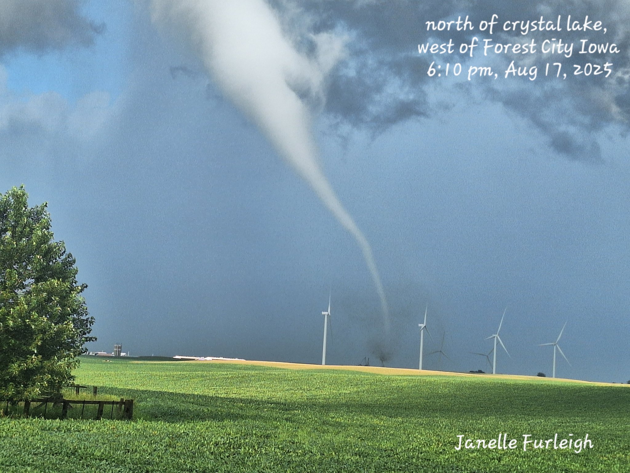
Welp, guess who missed this brief one in Iowa.
First tornado in the States in a good bit there
Maybe an unpopular opinion, but saying "indirect impacts" related to Hurricane #Erin is likely not communicating the very real threat of surf and rip currents to the public well enough.
There were 50 rescues reported in Wrightsville Beach, NC.

There is a high risk of rip currents from today and on Thursday for most U.S. east coast beaches from South Florida to Massachusetts due to Hurricane #Erin.
Beachgoers are urged to follow information from lifeguards, local authorities, and beach warning flags. The best advice?

Looks like a tornado in Northern Alabama currently


.... Something bizarre happened to form this one, looking more at it.


Lasted for 2 frames here (Not seen 4:34, potentially seen 4:39, was likely doing damage 4:45, was gone by 4:51)
A Particularly Dangerous Situation Tornado Watch has been issued for southern Saskatchewan & Manitoba, Canada this afternoon. Supercells are expected to develop this evening along a warm front, posing a risk for large hail, damaging winds & a few tornadoes, perhaps some strong.

https://fxtwitter.com/Acedog112/status/1958278068633764291
(self-cross post, 4 images.)


Rare Octuplet Waterspouts Spotted! - Baltic Sea Waterspout Outbreak
Numerous waterspouts were spotted today (August 21) off the coasts off of Poland (12) & Denmark (8). One Danish observer saw 8 waterspouts in a row! See our World Waterspout Map at https://t.co/WPioHG02Jy


Satellite imagery comparison before and after the 2025/05/16 St Louis EF3 tornado. Very easy to see the fairly wide swath it cut through the region. Crazy number of people were (and still are) affected and displaced by this thing.


The level 3 area is mostly for excessive rainfall+ large hail+ damaging wind gusts,
Climate models recently indicated that a collapse before 2100 was unlikely but the new analysis examined models that were run for longer, to 2300 and 2500. These show the tipping point that makes an Amoc shutdown inevitable is likely to be passed within a few decades, but that the collapse itself may not happen until 50 to 100 years later.
Iceberg landscape with the midnight sun colours in Greenland
‘We don’t know where the tipping point is’: climate expert on potential collapse of Atlantic circulation
Read moreThe research found that if carbon emissions continued to rise, 70% of the model runs led to collapse, while an intermediate level of emissions resulted in collapse in 37% of the models. Even in the case of low future emissions, an Amoc shutdown happened in 25% of the models.
Scientists have warned previously that Amoc collapse must be avoided “at all costs”. It would shift the tropical rainfall belt on which many millions of people rely to grow their food, plunge western Europe into extreme cold winters and summer droughts, and add 50cm to already rising sea levels.
…
The new results are “quite shocking, because I used to say that the chance of Amoc collapsing as a result of global warming was less than 10%”, said Prof Stefan Rahmstorf, at the Potsdam Institute for Climate Impact Research in Germany, who was part of the study team. “Now even in a low-emission scenario, sticking to the Paris agreement, it looks like it may be more like 25%.
…
We found that the tipping point where the shutdown becomes inevitable is probably in the next 10 to 20 years or so. …”
https://www.theguardian.com/environment/2025/aug/28/collapse-critical-atlantic-current-amoc-no-longer-low-likelihood-study
(archived https://archive.ph/YcYTZ)

the Guardian
Scientists say ‘shocking’ discovery shows rapid cuts in carbon emissions are needed to avoid catastrophic fallout
UPDATE: Death toll from earthquake in Afghanistan rises to 1,100, more than 3,500 injured, government says

Super low chance but I'll take it
It has been dreadfully tame over the USA recently (in terms of weather.)
Inb4 crazy tornado outta nowhere west of the Rockies that does basically nothing in the middle of nowhere
i've talked about my personal theory before- right? That'd be a sign to REALLY pay attention to the next few days east of the Rockies, lol.
(Also since this above forecast is for tomorrow- you'd need a Cali tornado like... 2 hours ago lol)
You mentioned it a while ago in this thread iirc
I do remember you mentioning it vaguely
Something about “watch the weather for the next 3-4 days” right?
Usually- if something spins up W of the Rockies, watch E of the Rockies for the next 1-2 maybe 3 at the most days, usually an event is somewhat forecasted- but that tornado W of the Rockies suggests an upper end event may verify
i've bounced this idea with people so much smarter than me now and no one's really disproved or proved it yet, so it's in the solid theory period of it's life.
... Huh.


A severe thunderstorm watch has been issued for parts of CT, DE, ME, MD, MA, NH, NJ, NY, PA, RI, VT until 8 PM EDT

Main concern is ME/NH border imo.
Throwing a bullshit "gut feeling didn't really look at the models too closely" target of... Rochester NH?
Good enough road network if you were storm chasing today.
there was likely a tornado today near Holden, MA
A tornado that struck a central Japan city last week during Typhoon Peipah was one of the strongest ever recorded in the country, packing winds of around 270 kilometers per hour, Japan's weather agency said Monday.
#Japan #WritingCommunity


"Footage of the tornado near West Wyalong at Caragabal, NSW Australia today by Neil Davies on FB."
︀︀
︀︀THIS IS THE BEST TORNADO FOOTAGE WE HAVE EVER SEEN IN AUSTRALIA
︀︀
︀︀@ReedTimmerUSA
︀︀@accuweather @BOM_au

M7.3 estimated off the coast of Russia again.
USGS prelim of M7.7 👀 (https://earthquake.usgs.gov/earthquakes/eventpage/pt25256000/executive)
(aand downgraded to 7.4)

Is that a dust devil or is it actually being reported as a tornado? I can't see an obvious mesocyclone or supercell formation
It was a supercelluar tornado

w/ notable damage being recorded (Mobile homes significantly damaged.)
Bad tornado damage from the tornado near Montezuma Creek, Utah earlier this afternoon - multiple mobile homes were completely obliterated and swept away. Source is ABC4 via this link: www.abc4.com/news/southern-utah/san-juan-county-tornado/ #UTwx


Btw- image #1 there- Mobile home eviscerated- built wooden steps still remain, biggest killer for these types of structures is how easy wind can get under it and turn whatever you're in into a sail.
Sheesh. What was it rated? Ef3-ish?
It is still being rated,
But the contextual there suggests probably surprisingly lower than usual for atleast that first structure pictured.

^Technically an event to watch today, as yesterday had tornadoes W of the Rockies, Per my (unproven) superstition, might have decent odds of verifying, and potentially oververifying

^Already got 1 observed tornado in SD
Tornado Warning including Cannon Ball ND and Livona ND until 3:00 PM CDT

..lil late because i was busy- but... yet, oververified, went PDS.
There's a bit of a mini spinup heaven going on rn in ND.


Strong tornado nearing Denhoff, ND

TORNADO ON THE GROUND in North Dakota via Tornado Paigeyy and Bryce Shelton!
︀︀
︀︀We are LIVE: www.youtube.com/watch?v=R5FBc8CUG0w

STRONG WEDGE TORNADO near Denhoff, ND!
︀︀
︀︀We are LIVE: www.youtube.com/watch?v=R5FBc8CUG0w


Look I'm going to sound absolutely insane but I wasn't really watching this event because my superstition didn't happen. (No tornadoes W of the Rockies, I know I sound like a broken record.)
... This event did absolutely nothing of note, I've actually managed to sway some other storm chasers into researching this more.
Monitoring a potentially significant flooding event that could occur Monday from Hurricane Imelda... Biggest concern is the Carolinas.
Shockingly good agreement from the overnight / early Thursday AM EURO & Canadian models on a hurricane #Imelda striking South Carolina late next Monday. So fast with Imelda that it misses potential Fujiwhara pinwheel interaction with Humberto like the GFS and Euro AI continues to show (not pictured).


Pathing will be .... immensely chaotic if Humberto strays closer, you'll start to see the Fujiwhara effect. (Making predictions... tough.)
Still watching, should be given a name today,

Put bluntly, there is a 50% chance someone in the Carolinas experiences a flood disaster next week.
I understand that's a frustrating forecast. How do you plan for a 50 percent chance of a high-impact event? Prepare as if it's going to happen. If it does, you'll be ready. If it

An area of low pressure over the Caribbean is expected to develop into a tropical system this weekend. There are 3 possible track scenarios, which will determine what impacts (if any) there are in central NC. There is still a lot of uncertainty, so stay tuned for future updates!

Tropical depression Nine is expected to strengthen and bring tropical storm conditions to portions of the central and northwestern Bahamas through Sunday night. Tropical storm conditions are also possible along portions of the east coast of central Florida beginning Monday, where a Tropical Storm Watch has been issued.
︀︀
︀︀Rainfall associated with this system will continue to impact eastern Cuba, Hispaniola, Jamaica, and the Bahamas through the weekend, which will likely produce flash and urban flooding. Mudslides are possible in the higher terrain.
︀︀
︀︀There is a significant threat of heavy rainfall early next week from coastal Georgia through the Carolinas and into the southern Mid-Atlantic states, which could cause flash, urban, and river flooding.
︀︀
︀︀The depression is expected to be at or near hurricane intensity when it approaches the southeast U.S. coast early next week, where there is a risk of storm surge and wind impacts. Although it is…


A direct hit does not appear likely, still watching for potentially catastrophic flooding from the associated rain however.
Wow that got yanked back out to sea hard.
No longer really expecting flooding to be an issue.


For real, seems like UKXI was the lucky winner this time. Wonder what the others missed?
It really (in this case) was mainly determined on not only where this system was- but where the neighboring hurricane (Humberto) was, and how strong it got. Lot of variables not typically seen were thrown into the pot.
My memory is hazy, but didn't a similar thing happen during the 2005 hurricane season? Two systems got really close and one did a U-turn out to sea?
Bermuda may have some issues later this week from Imelda


Multiple building collapses in Bogo City, Philippines, following a shallow 6.9 earthquake


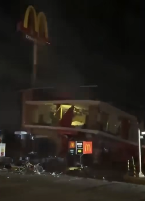
Four EF-2 tornadoes have been confirmed in western Quebec from the tornado outbreak on September 5th:
︀︀
︀︀Lac Joannès, QC EF-2 - 134 mph (215 km/h)
︀︀Lac Disson, QC EF-2 - 134mph (215 km/h)
︀︀Senneterre, QC EF-2 - 118mph (190 km/h)
︀︀Lac Twin Sud, QC EF-2 - 118mph (190 km/h)
︀︀
︀︀#qcstorm


The U.S. Government is closed & this account will not be updated.
@NOAA websites & social media necessary to protect lives & property WILL be maintained.
For critical weather information from NOAA's @NWS, please visit
https://t.co/3brQVw8eH2
Learn more:


Due to the federal government shutdown, this account is not being actively updated. For more information visit: https://t.co/qWif9aZm3q

!!!!!!
First EF5 since 2013
This was the site of the EF-5 DI near Enderlin, North Dakota.
Filled train cars aren't just going to be thrown in weak, or even low-end violent tornadoes. This is a clear example of a high-end tornado.

See here for discussion directly after the tornado.
First ND EF3+ in over a decade and it's an EF5
Notable thing- this is the first tornado to be given an EF5 rating for a non standard damage indicator (usually called a contextual.)
.... Certainly keeping an eye on other tornadoes from this year to see if they get updated.
This frame was around the time the train cars were thrown.

They cite this paper,
https://journals.ametsoc.org/view/journals/mwre/152/8/MWR-D-23-0251.1.xml

AMETSOC
Abstract Currently, the enhanced Fujita scale does not consider the wind-induced movement of various large compact objects such as vehicles, construction equipment, and farming equipment/haybales that are often found in postevent damage surveys. One reason for this is that modeling debris in tornadoes comes with considerable uncertainties since ...
I am very interested in 46°35'5.29"N, 97°34'11.74"W

Looks like notable ground scouring ocurrred.


This type of subvort marking is typical on the front-right segment of the tornado,
The current path is too far south at the EF5 segment.
(I also have it marked as 250+? MPH due to Ethan+ NTP's math for the empty train car being thrown that far. They both have it at 260+)

Where the estimated centerpoint of the path should probably be for this segment vs where it is currently.


So TLDR: extra spooky tornado happened
The full math done by Tim Marshall for the rating


NWS first damage path estimate vs mine vs "areas of most note"- (potential ground scouring)


Woah! Tornado in NORWAY! Apparent clockwise-spinning landspout… remarkable!


A MODERATE risk is in effect in our Day 2 Excessive Rainfall Outlook. More details: https://t.co/FQU5sblUHQ
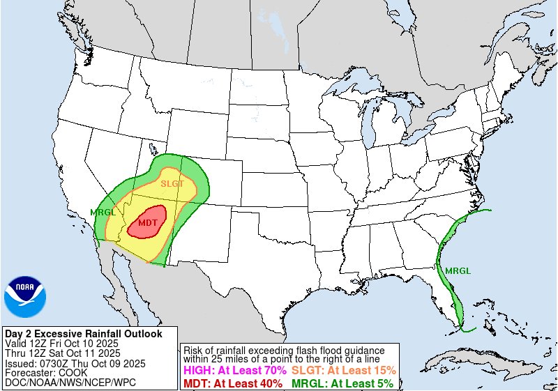
Decent chance of flash flooding tomorrow for parts of Arizona.
Cyclical markings! ( 46°38'18.99"N, 97°25'36.77"W)

This is from the Enderlin EF2, which occurred directly after the Enderlin EF5, this one was likely much stronger than it's rating suggests, mainly (and luckily) tracked over farmland which hindered any potential significant damage.
This is a first for me- this detected a massive explosion at a plant in TN,


BREAKING: 19 people unaccounted for after blast at explosives manufacturer near Bucksnort, Tennessee - WKRN

Likely time of detonation was around 12:47:52 UTC.

Starforge PC https://starforgepc.com/moist-yt
Get Goof Juice and use code MOIST https://gamersupps.gg/moist
Our soap https://usecheeky.com/#starter-pack-offer
Gaming channel https://www.youtube.com/@MoistCr1TiKaLGamingOfficial
This is the greatest copyright paper of All Time
...Storm chaser suing Charlie, oh boy.

My name is Aidan and I’m an engineering student at the University of South Carolina. Recently, I’ve conducted an analysis of the cycloidal markings on the Enderlin, ND EF5 tornado using my Cycloidal Coefficient Method. Interestingly, the cycloids agree with the EF5 rating. [1/7]


(thread)
https://vxtwitter.com/weathernation/status/1977804027640598902
https://vxtwitter.com/restrictd_truth/status/1977844586589601955

The remnants of Typhoon #Halong slammed into the west coast of Alaska Monday.
An unknown number of houses have been reportedly swept away with an unknown number of residents unaccounted for https://t.co/O3a1YjhZZ6

🚨 Typhoon Halong’s remnants brought 100 mph winds & catastrophic flooding to coastal Yup'ik villages in Alaska like Kwigillingok & Kipnuk. Homes are destroyed and people are missing.
National coverage is near-zero..
- footage from Cikigaq Paul.
#Hurricane #TyphoonHalong #Alaska
..I'll be honest- yeah, didn't hear anything about this, personally.... Forwarding to other channels to see if they've heard about it/ if anyone was watching that.
Might get a tornado in Los Angeles today 👀

Waterspout producing QLCS heading onshore, might get a brief one near the city...
Also keeping an eye on Saturday (Oct 18th), should be mostly a straight line wind risk, but a tornado threat is somewhat possible, depends on if there's storms in the area before the main line fires or not.


Tornado Warning continues for Malvern AR, Rockport AR and Perla AR until 4:30 PM CDT


In-depth meteorological breakdown of the June 20, 2025, severe weather outbreak centered on North Dakota, which spawned an EF5 tornado near the town of Enderlin, the first official EF5 in the US in twelve years. We'll take an incredibly detailed dive into the meteorology behind the entire setup, including an analysis of the background pattern, h...
A full meterological breakdown of the first EF5 since 2013.


Dramatic video footage shows the tornado that ripped through Ermont, just north of Paris, France, earlier this evening, causing cranes to collapse. There are reports of casualties. Credit: Alexandre Coutinho

▶ Play video
FxTwitter
·
I will agree w/ this poster that this does suggest it was decently strong at the time, Would not be surprised if France gets their first IF2(+) on record in a bit (last IF2 was in Morbihan in Feb.)
Certainly would be the first notable tornado in a majorly populated area for France (I believe, if my database searching isn't failing)
^Also- I am using the European Severe Weather Database (https://eswd.eu/en) for this
Shit. Diesnt Europe barely get any tornadoes compared to the States?
Huh so about 3-400? TIL
We get a lot of small ones.
Learned something new today, nice. Still a scary event for sure

vast disagreements in both track and intensity atm.


Pretty sure it's going to hit hurricane status- and potentially could intensify quickly, but anything after 72 hours is honestly up in the air.
^Also of note- it's near stationary, (Which is why I suspect the models are so uncertain about the whole thing- it's more "at the whims" to other changes in the environment instead of the usual where a system like this would influence everything else more, it's a complicated symbiotic relationship, but this one is leaning more towards being influenced, than the influencer, atleast right now..),*
last documented at moving 2 MPH WNW, which puts notable concern for Jamaica and potentially Haiti if it fully stalls out off their coastlines, flooding would be the major concern.
People are saying that Melissa will likely become a major hurricane by Sunday- and yes, the data does suggest it tenfold, but i'm still cagey on it due to how erratic it's been so far- If it does continue on it's implied path, it could very easily be one of the strongest hurricanes we've seen in that area in a while real darn quickly, but if it hooks a right and slams into Jamaica now and fizzles out before it can do so, that's probably paradoxically better? Weird situation.
Absolute worst case scenario is that it stalls out SW of Jamaica, intensifies immensely, flooding the area at the same time- then hooks NE and directly nails it at Cat4-5 intensity, tacking on immense storm surge to the already catastrophic flooding from the outer bands.
..... Optimistically, as of now, that appears unlikely to occur exactly like that.
Pessimistically, I can't rule it out, and something similar to that actually occuring is still on the table.
I heavily dislike trying to figure out what tropical systems are going to do due to situations like this, where the genuinely best outlook I can give is a shrug emoji.
^ As an aside, semi-worst case scenario still has feet of rainfall for a decent swath of the island, still would be absolutely catastrophic..
And as a fun lil thought exercise, I don't see a best case scenario that doesn't involve someone getting the short end of the stick somehow.
My theorized best case hypothetical still would dump just as much rain onto Jamaica, just without the additional threat of a very strong hurricane afterwards, ripping the bandaid off sorta scenario.
^This is all before you get into the diplomacy hypotheticals between VEN-USA, i'm not focused on that- but on that side, you kindof want this to take as long as possible for diplomatic meetings. (Things are pretty tense currently on that front.)
hahahahaha not happening....willing to eat a hat if it does, (204kts= 234 MPH)
This is what I mean by I do not fully trust some of the models' output currently

TS Mellisa is now moving W at 1 MPH 🙃
In ELI5 terms, how bad is that?
It's going nowhere- and avoiding land, which will (likely) allow it to get stronger and stronger.
What are the water temps like in the area?
