#Weather and geological phenomena
1 messages · Page 3 of 1


Winds are expected to pick up in the coming hours, this will likely be a historic fire.

Another video of the massive Palisades fire in Los Angeles, California. Reports of over a dozen homes on fire.
Tomorrow's Fire Weather Outlook per the NWS.

You can see subvorts in this, very wild.
This will undoubtably be a very historic fire for many years to come. Still uncontained, it is about to get so much worse.

This is the new fire i'd be concerned about given the current winds. (SW)

Especially since it's in the hills... Another tough one to fight and contain currently.

...That area may see 80-100 MPH gusts here in a bit, that'll be completely uncontrollable if that verifies out.
This reporter is on the ground with the CA fire: https://x.com/jonvigliotti/status/1876823108981538874
If you live in the Los Angeles area, download Watch Duty for realtime updates on fire activity. The Palisades Fire started near the 🔥 and is reaching the blue dot 🔵 where my team is getting gas. Stay safe.


All firefighting aircraft grounded due to high winds.
PDS Red Flag warning issued for LA.- Includes areas such as Hollywood and Beverly Hills.

Renamed to Eaton Fire. Reportedly 200+ acres.
#EatonFire in Altadena. 200+ acres.
Evacuations underway. More info to follow
USFS, Pasadena and LACoFD are in unified command @lasd @PasadenaFD @LACoFDPIO

KTLA has been covering both fires well and a lot of damage shown: https://ktla.com/news/california/wildfires/palisades-fire-los-angeles-live-updates/
Another on the ground journalist: https://x.com/lizkreutznews/status/1876770956661727277
A bulldozer pushing cars out of the way to create a path on Sunset Blvd to PCH.
#palisadesfire #pacificpalisades #breakingnews

…that’s an easy way to tell people it’s serious.
Granted, all fires near metro areas are serious. But even then.
Immediate evacuation orders have been issued for parts of Altadena, Ca. as well as Kinneloa Mesa, Ca.
Intense fire beginning to enter a major metro area.
#cawx

They told people to abandon their cars and run for it when this initially started, roads were gridlocked and the fire was approachin quickly. This unfortunately turned around and slowed response time because the roads were now blocked.
Oh, that explains why, my bad.
The more I know!
OLD POST 6 hours ago it was bad- People understood the threat, but unfortunately everyone tried to leave at once.
https://x.com/JonVigliotti/status/1876732377201795491
Gridlock traffic in Pacific Palisades, threatened by the Palisades Fire. Drivers have abandoned cars, blocking people from trying to escape in neighborhoods currently threatened by flames.

area of above screenshot+ direction, Best combined w/ this.
Whole entire area was practically stuck.

City of Santa Monica is issuing an Evacuation Order for all areas of the city north of San Vicente. Evacuation Order: Immediate threat to life. This is a lawful order to LEAVE NOW. The area is closed to public access.
Updates: https://t.co/BTF6UsEbYG
65 MPH sustained winds, gusts to 85 so far, first signs of the expected uptick.

CONTENT WARNING Video recorded by two men surrounded by fire in their home, no injuries, but it's a really bad situation.
||https://x.com/AZ_Intel_/status/1876842554966077505||
I don't think this is the same channel shared above:
https://bsky.app/profile/bencollins.bsky.social/post/3lf7cbrnkzs2l
Can't stop watching this live coverage. Increasingly apocalyptic.
A direct link if you want to tune in versus read recaps
https://www.youtube.com/live/59hLkc6FDvQ?si=lavmBg-iOMoWVfdt

Fire crews on the scene of that brush fire in Pacific Palisades report the blaze has grown to about 10 acres amid roughly 40 mph winds, and structures are be...
I'm looking for another source about if this is true
I'm only finding that LAFD is asking their own employees to report their status, not as it's being reported on some areas of social media, that they want anyone with firefighting experience to call.
https://vxtwitter.com/LAFD/status/1876817689949208942?t=1aVBxxIHk4WG1_QKS1D4cw&s=19

All #LAFD members currently off-duty are to call the DOC 213-576-8962 with their availability for recall. #palisadesfire
||https://bsky.app/profile/ericholthaus.com/post/3lf7bf5ba4s2j||
idk validity but I might as well share edit: ok the link is misinfo
The Los Angeles Fire Department is doing something they’ve never done before — they’re asking anyone with firefighting experience to assist in fighting the #Palisades fire and the #Eaton fire and reach out to 213-576-8962.
This could become one of the worst firestorms in California history.
Reposts
1185
Likes
2060
Quotes
115
Yeah that was what I removed above.
https://vxtwitter.com/LAFDtalk/status/1876846052562571727?t=rZuJxxVJEzEE6OeGx99hxQ&s=19

This is NOT accurate. The LAFD is running a recall for our OWN members and not anyone else. Please do not further the misinformation. Thank you.
Ok, thank you for the info 🙂
Update: link is misinfo, please ignore the validity of this!
Because consequences can be dire (eg, the hotline will get shat up by people calling in good faith) when I see something unusual I go looking for a second independent source (first stop is the actual department).
Fair point, thank you. 🙂
that's ok! We're learning. And this is turning into a MESS
This is a parody account of Kash Patel thankfully but the reach is alarming

Peak winds are expected to end at like 5 AM tomorrow. (Their time)
It is not going to be pretty in the morning.
I meant the misinformation going around, but yes, this is dire and scary
Light content warning- Evacuating patients, some w/ prior injuries. (Nursing home?)
||https://twitter.com/FirePhotoGirl/status/1876847716212318475||
Possible mass casualty incident at Duke's Malibu. Multiple burn victims.


Photographer @WallySkalij captures the fire along Pacific Coast Highway in Malibu. Read all the latest coverage here: https://www.latimes.com/california/live/pacific-palisades-fire-updates-los-angeles
Wild footage. (Especially 20 seconds in- that's on the beach.)
Also hence why “idk validity” was added, basically opened the floor to people checking me on the info, which you swiftly did
I'd do your own checks too (since the point of the server is research and I assume you want to research)
Was also informed about where to check for proper updates since I’m not fluent in all things firefighting. Will keep it in mind for the future
It looks like Biden is in LA right now.
As of now, President Biden remains at Los Angeles International Airport (LAX), though it’s unclear whether the trip will be rescheduled. No further details have been provided by the White House at this time.

In an unexpected turn of events, President Joe Biden's scheduled trip to the Coachella Valley has been canceled, sources confirm. The disruption is attributed to the high winds currently affecting both the Los Angeles area and the Coachella Valley.Reports indicate that President Biden’s flight, which was set to land at the Thermal Airport at 10:...
Still doesnt diminish the horrible situation that is happening over there
https://x.com/ShorealoneFilms/status/1876856518471012680
DISTRESSING CONTENT
Freelance journalist cut off by fire, calling mayday via Twitter.

||https://fixupx.com/Lot71/status/1876860547053879802
|| puc from airplane, nabbed from Project Owl

#PalisadesFire from flight to Burbank — shot just before plane turned around to head back to Vegas because we couldn’t land in 80mph winds. Plus, #eatonfire east of Pasadena.
The top of Kirkwood is now gusting over 200 MPH 🤯

(Literal top of a mountain- expected gusts for populated areas will be much lower- 100 MPH at most in valleys atm.)
(But if this wind speed is verified, one of the highest non-tornadic wind gusts recorded in recent history.)
We have a new fire near the 5fwy at Lankershim. The 5 is going to be getting shut down.
hotspot mapping

Bulldozer clearing Sunset of gridlocked cars
https://www.ddinstagram.com/reel/DEjH7Q2pioI/?igsh=aW1nOHdxbGhkaDRu
@lacountyfd Dozer 5 clearing Sunset Blvd of abandoned vehicles at the #palisadesfire
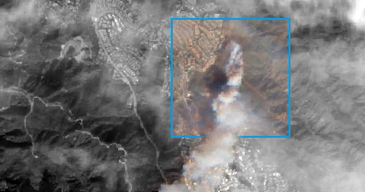
So they've stopped updating the estimated fire perimeter since late Tues evening- but VIIRS has a good rough scope

Meanwhile in the Plains we're freezing our asses off. Puts a fine point on the extremes that climate change is bringing us
Dangerous fire weather conditions are ongoing in southern California with the most extreme conditions expected this morning. Winds should gradually weaken somewhat through the day, but critical fire weather conditions are expected to persist into Thursday.

random question: Why is weather considered off-topic?
mainly because it's sporadic and when it does hit- lot of news in a very short period of time, but most of the year- idle chit chat about snow or local events. This channel originally started for me to nerd out about tornado geolocations.
(Might also be a bit related to the fact that you can "self monitor" weather events a little easier than most news events, thanks to the radars being open to the public.)
This absolutely SHATTERS the record for highest wind gust ever recorded at the airport
Previous record was a mere 67 mph on Dec 21, 1997
(Quoted tweet for above- 85 MPH gust at the airport.)

At 5:00 AM PST, 4 NW Altadena [Los Angeles Co, CA] Mesonet reports Non-Tstm Wnd Gst of M100 MPH. Mesonet station 149SE Mt Lukens Truck Trail (SCE). #cawx https://t.co/ExbG8mGVTQ

Alright folks resource time
You can pull this feed up in VLC or on http://vidgrid.tk.gg https://abcnews-streams.akamaized.net/hls/live/2023560/abcnews1/master.m3u8
it's ABC's live raw feed from the fires
https://ops.alertcalifornia.org/tileset/19492
Custom tile display of Palisades Fire coverage
Palisades Fire scanner https://www.broadcastify.com/listen/feed/38651
Broadcastify.com
Los Angeles County Fire V-1 Live Audio Feed on Broadcastify.com
Eaton Fire scanner https://www.broadcastify.com/listen/feed/38653
Broadcastify.com
Los Angeles County Fire V-3 Live Audio Feed on Broadcastify.com

Twitter won't let me upload a GIF for the camera, but you can literally see the Saddle Peak 2 camera get swallowed by the Palisades fire near Malibu, CA
Adding onto this- good fire cam resource for the area.
https://fxtwitter.com/Marios_WX/status/1877006083639611856
When helicopters can fly safely again- there will be some absolutely devastating aerial pics.

ABC7 has devastating scenes from Pasadena, CA.
Geolocated to (34.04720212481078, -118.52600777759974) moving south.


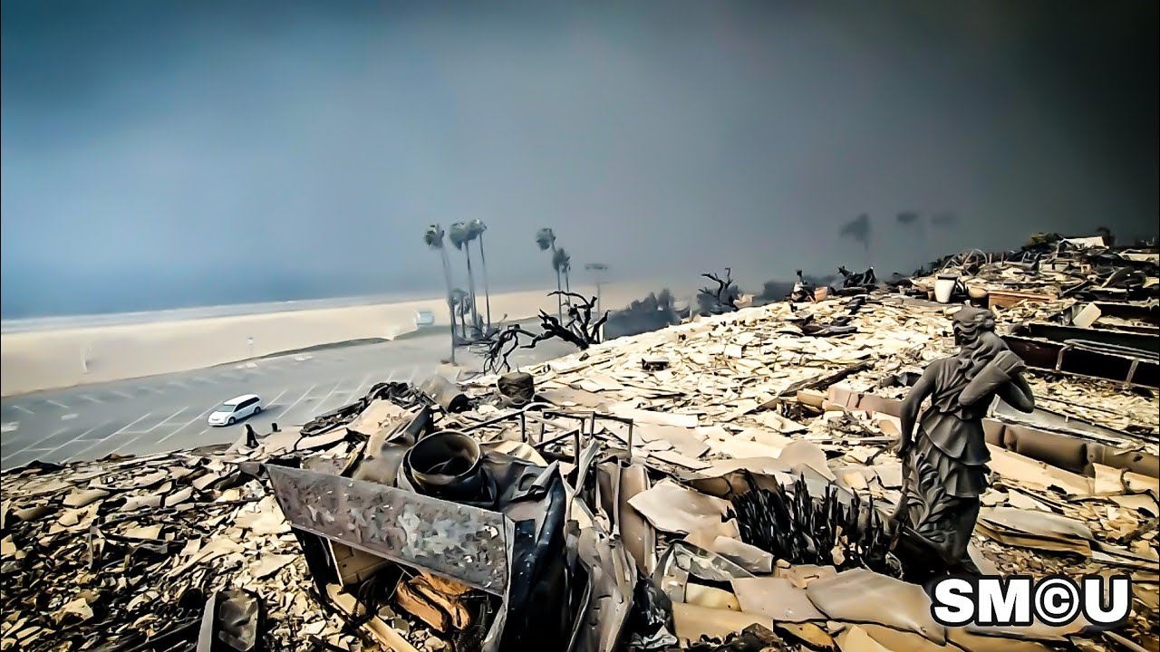
This is what’s left of the Pacific Palisades. The mall survived. Most everything else is gone. Homes, apartment complexes… businesses.
oh wow
For context, this image of gridlocked traffic yesterday is in the red circle. Pin is where that geolocated footage above is.
A notable section of this area is likely damaged.


https://x.com/abc7gabe/status/1877057985790226899/photo/2
Looking at 34.045136720511834, -118.52340306811435, facing SE.


Area in question in relation to the last perimeter update.

Wow, that is awful. Good work to id
To give an idea of the nominal loss here, here is Zillows estimated values for the residential properties on one block in your pic. It’s about 40m plus some commercial properties.


Yeah this will make a good effort at being the most costliest wildfire in American history, probably.
Current "record" is the 2018 Camp Fire (aka the Paradise Fire)- $16.65 billion estimated in damages.

@BenNollWeather Nearly every single home and most businesses on Via de la Paz, a big street in the Palisades, is gone. Swarthmore next to it, same.
Geoconfirmed to (34.0368, -118.5297) check twitter post for verification images.
https://x.com/Acedog112/status/1877101636096549367
I'd estimate this entire dotted section is significantly damaged if not destroyed.

The estimated perimeter map was updated finally.


Image #3 geolocated to around (34.0376, -118.6077).
Multiple houses missing.
#CAwx #PalisadesFire #PalisadesWildfire
Quoting AccuWeather (@accuweather)
Devastating images of homes burned by the #PalisadesFire along the Pacific Coast Highway in Malibu, California. https://bit.ly/40fCEuC
Getty Images have some wild photos i'm attempting to geolocate.
https://www.gettyimages.com/detail/news-photo/person-uses-a-garden-hose-in-an-effort-to-save-a-news-photo/2192997154

Eaton fire is getting deep into the suburbs: Fire at 2 dragons martial arts on KTLA. Location: 2490 N. Lake Ave. Altadena, CA 91101


If you have others you want help to find, I'm happy to give it a try.
Its a crazy fire: https://bsky.app/profile/ivymike.bsky.social/post/3lfbebonra22q
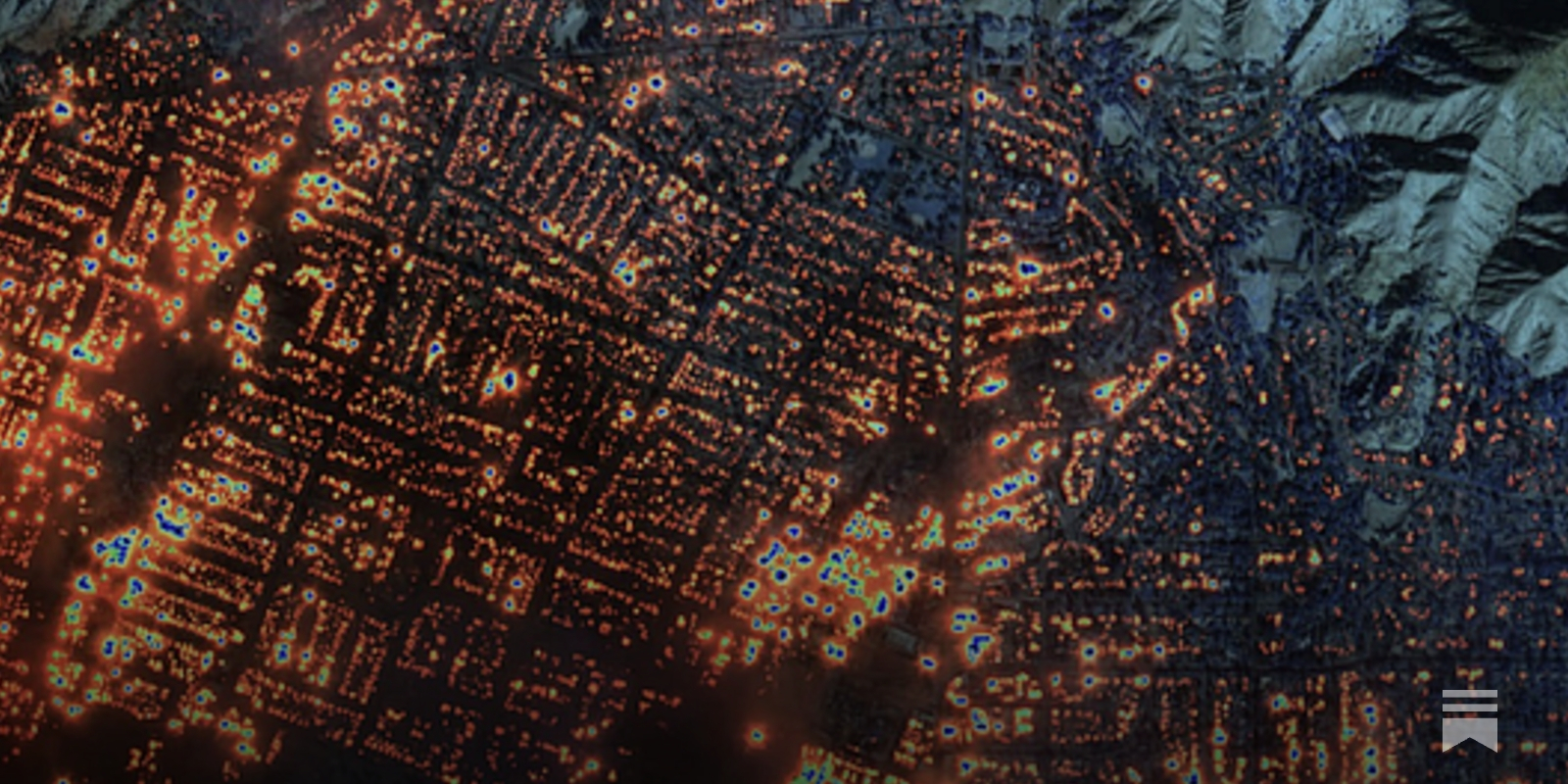
The NASA FIRMS tool showing the Eaton fire heat map overlayed on Altadena.
firms.modaps.eosdis.nasa.gov/map/#d:today...

More photos of the aftermath of the Palisades fire, posted by the local newspaper the Palisadian Post on their Facebook page: https://www.facebook.com/palisadian.post/posts/pfbid035PQL1h2FutKKvAoMDcirUVQKZVmujS9rj39c7j2Qm3k6w8o2dxLuwW2dFUC3C3fxl

As the Palisades fire reached 15,832 acres with no containment on Wednesday, January 8, it was estimated that over 1,000 structures have been affected, according to Los Angeles Fire Department. The...
Although I grew up there, it's very hard to recognize the buildings!
Chase bank in downtown Palisades on fire with crew fighting: 15209 La Cruz Dr, Los Angeles, California
https://bsky.app/profile/plasticjesusart.bsky.social/post/3lfbeecq7xc26

Pacific palisades fire copyright Nick Stern 📷 no unlicensed commercial use


https://bsky.app/profile/jimmyalto.bsky.social/post/3lfb56rqz322x
I've got the end of the video to here -
https://maps.app.goo.gl/zugG6N6tynWnAZvm9
I doubt the $25m figure is right but still there's a lot of homes gone here, pretty far away from palisades


#PalisadesFire
every $25-Million-dollar house on the beach along Pacific Coast Highway in #Malibu is gone...

34°02'13.7"N 118°36'31.3"W
Another view that is consistent with @unborn timber 's suggestion of damaged area. Air above Iliff St. & Bestor Blvd in Palisades. Could be a couple blocks closer to sea.
https://www.google.com/maps/place/34°03'04.6"N+118°31'11.8"W/@34.0512923,-118.5248249,936m/data=!3m2!1e3!4b1!4m7!1m2!2m1!1sChase+Bank!3m3!8m2!3d34.051288!4d-118.519954!5m1!1e2?entry=ttu&g_ep=EgoyMDI1MDEwNi4xIKXMDSoASAFQAw%3D%3D
https://bsky.app/profile/noagendamedia.bsky.social/post/3lfbebndgwh2y

🚨#BREAKING: Aerial shot of Pacific Palisades showing a whole neighbourhood destroyed after brush fire. https://t.co/hARcWFLoQM - https://x.com/Worldsource24/status/1877139696033075583


Zillow has this strip as 2-8 million estimated. I checked history of the highest estimated prices and found up to ~5 million prices. https://www.zillow.com/homedetails/19858-Pacific-Coast-Hwy-Malibu-CA-90265/20551608_zpid/


Zillow
19858 Pacific Coast Hwy, Malibu CA, is a Single Family home that contains 2501 sq ft and was built in 1983.It contains 4 bedrooms and 3 bathrooms.This home last sold for $5,200,000 in September 2021.
The Zestimate for this Single Family is $5,670,800, which has increased by $12,490 in the last 30 days.The Rent Zestimate for this Single Family ...
I'd agree with your judgment.
KTLA has a cool thing with their helicopter camera. It drops a road map over the live image: https://ktla.com/on-air/live-streaming/

MAJOR EMERGENCY: Hollywood Hills fire spreading RAPIDLY towards Hollywood Blvd


DESPERATION: Firefighter uses traffic cone to retrieve water from a puddle as LA is running out of water
Pray for SoCal🙏
This is such a weird fire event- all of the people not evacuating and effectively working as "localized" firefighting squads for their neighborhoods is very effective, at least on first glance. It is effectively full guerilla warfare against the elements currently.
Thread with satellite imagery of the California wildfires.
Some Maxar imagery showing some of the preliminary damage. Sort of insane to see how widespread it is for such a highly populated area
This video seems to be filmed by someone on a bicycle. It's hard to find words for the level of loss in this video. If I have time I will try to map this out, maybe starting around 15:50 where the damage begins to be shown. Before this point in the video, the amount of material and personnel seen in this staging area is staggering.
https://www.youtube.com/watch?v=kfAY0x5CT7k
On Wednesday, January 8, 2025, the Pacific Palisades Bowl Mobile Estates, a well-known mobile home community along the iconic Pacific Coast Highway, was completely destroyed by a fast-moving wildfire. Located at 16321 Pacific Coast Highway, across from Will Rogers State Beach, the park’s 172 mobile homes were reduced to rubble, leaving residents...
yesterday vs today

16:49 is at 16001 CA-1
Los Angeles, California (34.0367942,-118.5376133)


Would this or #disinfo-and-propaganda be an appropriate place to claims of suspected simultaneous arson?
People are lighting fires in otherwise non-burning urban areas of LA. Saw this happen first hand at 302 Pico in Santa Monica. Called it in & fire dept & police responded. Stay safe and call in any activity ASAP. We don’t need more flames out here.

34,0089077, -118,4883294
What is your evidence that this is MDM?
I don't know that it is or not, I'm saying that that claim he's making doesn't immediately seem verified by the footage he's providing, so it could be good to try to verify if it is or isn't MDM
So you're looking for tips on how to research this? I'd keep that request here.
If you find a way to prove it, you can post a write-up in #show-your-work . Although arson investigation is a very specialised field, so be very careful.
New weirdest thing i've ever used to geolocate- tree branches
https://fxtwitter.com/TannerCharlesMN/status/1877197071809204697


Nothings left. #PalisadesFire #fire #cawx

Los Angeles officials hold news conference on response to wildfires in California.
–––
Subscribe to ABC News on YouTube: https://abcnews.visitlink.me/59aJ1G
Watch 24/7 coverage of breaking news and live events on ABC News Live: https://www.youtube.com/watch?v=gN0PZCe-kwQ&ab_channel=ABCNews
Watch full episodes of World News Tonight with David...
 Welcome to the club.

EXCLUSIVE: Homicide detectives with LA County Sheriff's en route to 3 homes in #PalisadesFire and #EatonFire area where what appear to be human remains were found. Here in Malibu, it was deputies doing a welfare check on someone reported missing that made the discovery @foxla
Warning if you're looking into the event
The Weather Channel accidently showed a fatality on air, fully burned to the point of skeletonization (?- there's likely a term for this, but completely burned to the point where bones are the only thing left.)
LA Metro fares cancelled due to infrastructure damage
https://bsky.app/profile/lapublicpress.bsky.social/post/3lfdftmvttk2w
Metro fare is cancelled today, LA. Swipe through for services alerts and the lines that are impacted.


Body recovery ongoing in Malibu.
Body recovery- does not directly show it, but adding NSFW just in case.
||https://x.com/jeremyreporter/status/1877458247415685599||
Additional image
||https://x.com/GigiGraciette/status/1877457258251952364/photo/1||

Thank you, fire watchers!
Unfortunately a new, wind-driven fire (mainly burning in grass and brush) to report: #KennethFire, headed for LA/Ventura County like. Oak Park and surrounding communities at risk as wind pushes this fire quickly to west and south under continued Red Flag Warning. #CAwx #CAfire

https://x.com/BNODesk/status/1877506958866936281
Honestly- mood.
An emergency alert has accidentally been sent to all of Los Angeles

Initial @CAL_FIRE Aerial Survey for #PalisadesFire @LACoFDPIO @LAPDPIO @LASDHQ

Just in case this helps, https://lacounty.gov/emergency/
The Follow Up Alert ...
https://cdn.discordapp.com/attachments/772656322431942687/1327075313842126938/Screenshot_20250109-161938.png?ex=6781beb2&is=67806d32&hm=a70ebdb38756228f6dfa3e28bf1c56a1f9257ed9cb891d21e89d1d0dda0d7455&


NBC Los Angeles
Fire officials in Southern California have informed the FAA that a firefighting aircraft struck a drone as it was flying over the Palisades Fire near the Los Angeles County coast.
someone is going to jail for a long time
plane landed safely
https://www.broadcastify.com/dashboards/?uuid=c44d6768-cdce-11ef-9e04-0e98d5b32039&t=7142
Live scanner for the fire response
Broadcastify Feed Dashboard - Los Angeles Area Fire Coverage

Some duct tape will get that in the air again
Speed tape, but I'm not sure this is within specifications. https://en.wikipedia.org/wiki/Speed_tape

Speed tape is an aluminium pressure-sensitive tape used to perform minor repairs on aircraft and racing cars. It is used as a temporary repair material until a more permanent repair can be carried out. It has an appearance similar to duct tape, for which it is sometimes mistaken, but its adhesive is capable of sticking on an airplane fuselage or...
Not for structural damage like that no
Speedtape is just for pinning something down temporarily
or fixing a panel gap

See updates on Los Angeles County wildfires as flames continue to threaten homes in Pacific Palisades, Altadena and elsewhere.
Parts of Encino and Tarzana are now under evacuation orders

Astronomy Magazine
The key NASA center remains under a mandatory evacuation order, but officials say both it and Mount Wilson are protected for now.

Fire tornado’s spinning up on Mandeville Canyon as palisades fire breaches the ridge towards Encino. Wild stuff.

Our state of the art Pléiades Neo imagery specialized satellite reveals Palissade Wildfires in Los Angeles, USA in very high-resolution enhanced by Pléiades Neo
400-megapixel image of the aftermath of the Palisade area.- Very handy for cross checking if a suspected house is still standing
I will be using this to specifically map destroyed structures,

I have so fucking more left to map.

Calling it quits for today. I'd estimate over 1,000 structures in the area I went over alone. I stopped counting for sanity's sake. 99% of the northern segment of this area is leveled.


This segment had the most "structure survivors." in the northern destruction, mapping this felt like mapping an inverse tornado path. Very curious to see if these were patches of people who stayed behind who held out together (Specifically that stretch of 9 houses in a cluster along Bester BLVD, Whitfield AVE, and up onto Mc Kendree AVE)


Does anyone have a current % of containment for this fire?
More devastating news. We are in densely populated Mandeville Canyon above Brentwood and homes are on fire. Fire slowly making its way down the canyon. This exposes entire regions of west LA to spread of fire.

apparently Amtrak’s continuing with their pre-scheduled track maintenance in the LA area
https://bsky.app/profile/keribla.bsky.social/post/3lfih253aa224
the Amtrak track closures page
https://www.pacificsurfliner.com/plan-your-trip/alerts/travel-advisories/#trackclosures
It is literally insane to me that Amtrak picked THIS WEEKEND for their pre-scheduled maintenance and shut down the train out of LA instead of rescheduling the maintenance as people are fleeing for their lives


Learn about ongoing construction projects that contribute to improvements in rail travel in Southern California, and stay ahead of planned service disruptions.
Here is look at the fire weather risk at a glance from today 1/11 through Tuesday 1/14. Very dangerous fire weather continues across portions of southern California where ongoing fires continue. Offshore flow is expected to peak again on Tuesday with high end Critical conditions.

Palisades fire is at 11% containment.
Eaton Fire is at 15% containment.
Live updates: Since the wildfires sparked on Tuesday, officials have detected 48 privately owned drones flying over the fires, hindering aerial firefighting efforts, according to Los Angeles County Deputy Fire Chief Robert Harris. https://t.co/aBkleDjoAg
I'm guessing EW isn't a solution to not affect the aircrafts, why are people like this..
It's easy to track them down too since they all post it online
theres now a fact checking site https://gavinnewsom.com/california-fire-facts/

Get the facts about the Los Angeles fires.


Incident Management Situation Report
Sunday, January 12, 2025 – 0730 MDT
Status as of this morning:
https://www.nifc.gov/nicc-files/sitreprt.pdf

Coming here to share link to site where these are available https://www.nifc.gov
Yeah, a lot of good info and resources there. LA fires have already had more reported drone incursions than all of 2024 fires, and the peak year of 2016 (41 vs 48)

Wild that his fact check website has a "fact" that is demonstrably wrong.
FACT: Wildland firefighters don’t use hydrants — they use water tenders. And that is what has been used to ensure continued water access. Three million gallons of water were stored in three large tanks for fire hydrants in the area before the Palisades fire, but the supply was exhausted because of the extraordinary nature of this hurricane-force firestorm.
Even Type 6 engines (Modified pickup trucks to have water tanks and pumps, smallest of wildland firefighting engines) have tools to access fire hydrants. I worked on a Type 6 and we'd use fire hydrants to refill if that was the easiest available source. Having the ability to refill from a water source (hydrant, pond, lake, river, etc) directly rather than waiting on a tender is a nice thing to have, especially depending on how close that source is versus waiting on a tender to come to you. Tenders can also refill at hydrants

American Red Cross ► http://www.redcross.org
Direct Relief ► https://www.directrelief.org
Los Angeles Regional Food Bank ► http://www.lafoodbank.org/fire
Los Angeles Fire Department Foundation ► http://supportlafd.org
California Fire Foundation ► http://www.cafirefoundation.org
Baby2Baby ► http://baby2baby.org
In the midst of the LA fires, the ...

An investigation is underway into an unauthorized drone that hit a firefighting aircraft while it battled raging wildfires in Los Angeles last week.

Gift link: https://wapo.st/3Ci3ASa
Despite that — and warnings of an intense and dangerous wind event last week — a Los Angeles Fire Department spokesman told The Post on Friday that it was not the department’s practice to maintain patrols of past fire sites, even for a few days after fires have gone cold.
Washington Post
The Post’s analysis offers evidence that the Palisades Fire started in the area where firefighters had spent hours using helicopters to knock down a blaze six days earlier.
Perhaps there was some confusion over the difference between using a hydrant directly vs filling at hydrants.
The wildland fires I fought never used hydrants, but only because other water sources were closer. I can imagine sending a tender to a hydrant for refills when working in proximity to a municipal water system.
Maybe. That also isn't an official government page and is just a Gavin Newsom campaign page ("PAID FOR BY NEWSOM FOR CALIFORNIA"), so maybe they couldn't have any actual SMEs review it
PDS Red Flag warning 2 days in advance 

LA County has created Palisades Fire & Eaton Fire damage assessment websites where you can see whether a property has been damaged by the fires (and see photos of some of the properties). You can search by address or by using the map. Palisades Fire site:
https://t.co/sOo3YhUfeo

Incident Management Situation Report
Monday, January 13, 2025 – 0730 MDT
https://www.nifc.gov/nicc-files/sitreprt.pdf


By Thomas Fuller, Mike Baker, Blacki Migliozzi, K.K. Rebecca Lai and Jonathan Wolfe
In the hills above Pacific Palisades, there is crime scene tape and scattered debris, clues to what may have caused the initial fire that eventually raged through thousands of structures.
Prior to this year the earliest in the year an "Extremely Critical" fire weather outlook was issued was Feb 18 (2014-present under 3/2 tier system)
14 days into 2025 we will be at 3 days of extremely critical which is more than the entire year in 2015 (2), 2021 (2), & 2023 (1).

The Malibu surfing community is mourning the loss of one of their most iconic members, after Randall "The Craw" Miod was killed in the Palisades Fire last week.
Turns out the victim in this area was fairly well known locally.
Stayed behind defending his home, found deceased with his kitten.

🗨️ 185 ♻️ 1306 💙 3533
- CAUGHT ON ZILLOW
Popular Information has identified dozens of LA landlords who jacked up rents by as much as 100% after the fires started and thousands of people lost their homes.
California's price gauging law prohibits increasing rent by more than 10% during a state of emergency

CNN
A CNN analysis of the 10 largest US cities and other comparable departments shows the Los Angeles Fire Department is less staffed than almost any other major city, leaving it struggling to meet both daily emergencies and larger disasters such as wildfires.
hey @unborn timber have you seen the local gov created its own map: https://recovery.lacounty.gov/eaton-fire/
Want to add I really appreciate what you are doing and I imagine this community will assist immensely but also curious how to support this map advertised to residents. It does have some photo documentation.
Also @everyone I work in Altadena and am affected by the Eaton fire. If anyone has any questions just wanted you all to know.
A group of local researchers is organizing under the name Resilience Alliance-- please follow if you can:

4 Followers, 14 Following, 0 Posts - See Instagram photos and videos from Resilience Alliance (@resiliencealliance)
It appears to be mapped very similarly to how the NWS does tornado assessments- looks to be mostly internally vetted sources (sending someone down, describing the damage, take a photo)
In fact- this might be partially surveyed by the NWS.
Side gripe- i dont know why the hell the NWS can't use drones for assessing damage. (Like- ever, Heli trip, or satellite scan is aight- but everything else has to be in person. It's something Canada does that I wish we'd adopt.)
I do think you are right as I was at a home nearby and CalFire was going door to door to assess damage and take photos.
I think the drones create an issue with the helicopters who are getting up the mountain with water etc.
Given its "active fire"
For areas where fires are still active- yes, but i'm mainly referring to tornado surveys, which are typically next day affairs.
I see. Got it. There have been drone videos made I've seen online so maybe they will come in time.
I personally use it a lot for my mapping efforts (again- mainly tornado projects)- but the NWS tends to not use them even when sent the footage by the original filmer.
(Depends per office, but a majority wont.)
We used them to map the development we are advocating to conserve. It allowed a lumion viewer where you can move around and all these other outputs like a rendering of elevation and videos and more.
NEW:
That viral video claimed on social media to show looters pillaging a Los Angeles home amid the wildfires?
I found the woman who was living there. She says the footage shows her nephews and son rescuing her belongings as her rental home caught fire.

Big hurricane Katrina vibes
@mental lotus just confirming the wildfire office hours -- was yesterday?
Yes
It's recorded
Thank you @grizzled storm n where might I find a link
It's not recorded, I forgot the ?. But Aram did a fire talk that is somewhere, I will search for it

Play “Tracking Wildfires Using Open Sources” with Aram Shabanian by Bellingcat on desktop and mobile. Play over 320 million tracks for free on SoundCloud.
Here's is an article by Agnes that may also be interesting. You can customize your dashboard additional for wildfire. I will also link it in a minute. https://www.bellingcat.com/resources/2025/01/10/satellite-imagery-bands-guide/?utm_source=discord

bellingcat
Multispectral satellite images can reveal useful information about the world, such as mining activity and changes in vegetation.

Copernicus Data Space Ecosystem
How to add your own custom layers to the BrowserWritten by William Ray, Sinergise
Paul: I see these homes burning, if they just had a generator and a hose, you start sucking the water out of the The Pacific Ocean. Why don't they take the ocean water and put it in cisterns have a bunch of water ready when a wildfire shows up? Once again, bad local government.

semi-related & historical, but rhymes https://www.smithsonianmag.com/arts-culture/the-assault-on-salt-82694441/

Jathan Sadowski on the ecological, financial, social, and political crises competing to swallow us whole.
Not sure that i've seen this before; New Orleans has been placed under an "Extreme" threat risk for snow and sleet next week. #winterstorm

hello all does anyone know of a gis platform or layers for copernicus that would reveal levels of lead, etc. in the ash in Los Angeles? We are trying to establish areas of special concern and priority
Hi, just for your information: the @ everyone notification does not work here. We do not want people notifying the entire server for every question. You can simply ask your question in the relevant channel, which you did.
Oh thanks I thought it was thread specific, apologies @leaden mountain

Allen Media Group, who owns and operates 22 local "big 4" television stations across the US, and also coincidentally, The Weather Channel, has decided to cut costs by eliminating the jobs of every local meteorologist at all of their stations. all of them. a🧵
Corporate side of things, but yeah it's not goin so well for meteorologists atm
You could also ask in #tools-and-sites by the way. Not everyone may check in here.

Brutal period for southern Cali lately, this is like day 4-5 of being under the gun.
What does RH stand for in this context?
Relative Humidity.
They seem to be calling for 15% or lower. IIRC, risk climbs rapidly as the RH drops below 30%.
The basic idea is that low humidity sucks moisture out of the vegetation. And moisture loss is accelerated by wind, so those numbers look pretty scary to me.
Oh that makes sense. Thanks!

NEW: Two people from Oregon were arrested inside the Palisades Fire zone for impersonating firefighters. Police say they had a fire truck which was bought in an auction, were wearing CAL-Fire t-shirts, and claimed to be with “Roaring River FD”… which doesn’t exist.

(I was setting up v. 1.0 of Global Quake and this gave me a damn heart attack, haven't configured my alerts to be quieter yet.)

(European sorta version of the NWS's public forecasting network will no longer issue their forecasts for a fear of it being misconstrued.)
Notably- this is not governmentally ran, I believe it's a bunch of universities.
i'm going insane
https://www.flgov.com/eog/news/press/2025/note-press-executive-order-number-25-13-emergency-management-gulf-winter-weather

State of Emergency issued for FL for the upcoming winter storm system, specifically uses the phrase "Gulf of America"
As far as I can tell- every NWS office is still using the phrase Gulf of Mexico, thank god.
This includes the NWS offices covering FL, including- MOB, TBW, MFL, (TAE, KEY and JAX just refer to it as "the Gulf" or "The Gulf Coast", MLB straight up avoids mentioning it)
welp. hot off the presses. (Section below this states that w/in 30 days, the Secretary of the Interior shall take all appropriate actions to rename the Gulf, and to update the GNIS, and in turn, all federal references. Likely including the NWS if this doesn't get stopped)

I have so many questions
From what I have learned after a little digging, the U.S. Board on Geographic Names, under the United States Geographic Survey (USGS) is responsible for place names. I’m not sure if an executive order can cut it.
https://www.usgs.gov/us-board-on-geographic-names
The membership of the Board shall include one representative from each of the Departments of State, Defense, Interior, Agriculture, and Commerce, and from the Government Publishing Office, the United States Postal Service, and the Library of Congress. The Board may also include representatives from such Federal agencies as the Secretary, upon recommendation of the Board, shall from time to time find desirable, even though these agencies are in the departments otherwise represented on the Board. The members of the Board shall be appointed by the respective heads of the departments or independent agencies that they represent.
This would be a process that could take a considerable amount of time to finalize.
Yeah- they manage the GNIS (And are also the main "Earthquake" sorta division which is where most laypeople know em from)
And, it would take considerable resources ($) to change all of the maps, documentation, MOAs, legal documents regarding international partners, and so on.
Heads up for the Weather Community!
You can now find NOAA (@noaa.gov), NOAA Climate (@climate.noaa.gov) & NWS HQ (@nws.noaa.gov; still being set up) on Bluesky!
Reposts
735
Likes
1557
New Orleans, LA has received more than double the amount of snowfall we've received here in Anchorage, AK since the start of meteorological winter (Dec. 1). New Orleans: 8.0"
Anchorage: 3.8"
@NWSNewOrleans, we'd like our snow back. Or at least some King Cake in return. 😉🙃
Reawakening the Commons in California
this link is not working for me
might have been deleted
Hmm it does appear to have been deleted. Sad.
temp this morning (around 6* AM EST)
(Good typo, me, 10/10.)

sorry Kansas you don't get temperature
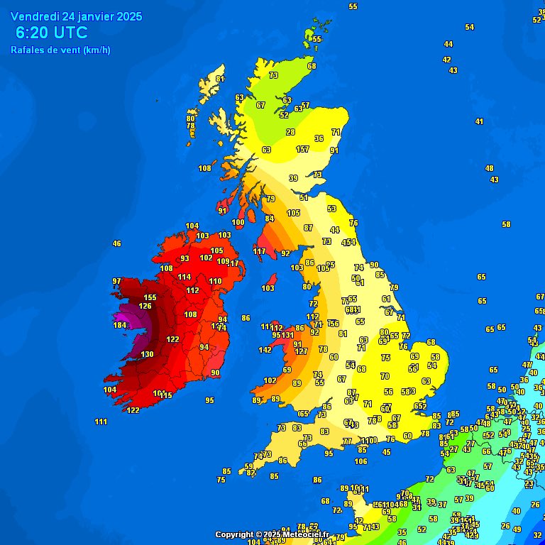
Bit windy in Ireland

Knock Airport @Irelandwest has recorded gust of 156kmh in last hour. Some station reports are missing from the 6am reports. #StormÈowyn
Taiwan is just gettin rattled lately

Two videos from residents of Pacific palisades whose home was destroyed - helps give context to how fast the fire swept into certain areas. Video 1: https://www.instagram.com/share/_gvkHsI1L


bweh
Goddamnit I forgot the name of that program…
GlobalQuake!
You can either run a whole personal instance which will absolutely eat up your RAM- ooor just use the public YT livestream https://www.youtube.com/@GlobalQuake which is what I recommend for like 99.999% of people, the standalone program is pure nerd shit* and the livestream has everything you'd likely need anyways.
(*I can say this as the local weather/ geological phenomena nerd.)
Fair warning- there will be alarms and whoops if the program detects an earthquake (This is configurable in the standalone program.) , and typically louder ones for more notable quakes, so like.. don't have it at max volume obviously unless if you like giving yourself a heart attack for a M5.0 half way across the world from you.
“Pure nerd shit”
Aka: the best type of nerd shit. The unadulterated shenanigans of information 😄
so cool, thanks for sharing
when the triangles (those are monitoring stations, right?) light up and flash ,that means that they've dected seismic activity?
USGS put this at a 3.9
If they flash with a green box around them- that's the system noticing "hey these are all showin somethin at around the "same time" (oversimplification, you should see a "wave effect")
There should also be a flashing box somewhere else that is where the estimated epicenter would be if they are seeing the same event. (but typically if it's not at the next stage, usually a false alarm)
If enough stations register an event- it starts acting like it is an earthquake, estimating the epicenter and intensity using all of the stations
OLD SCREENSHOT FOR EXPLAINING THE UI-
(Also for future searching- " GLOBALQUAKE UI ")
1- Max estimated "felt" intensity
2- "Letter grade"- this is how confident GlobalQuake is in it's own assessment, the more stations reporting matching data, the higher that grade gets. (I typically ignore all "events" with a rating of D or lower)
3-"Estimated Magnitude"- Uses each station individually and plots out what each station thinks it just felt, (may include events such as "we felt a lil shake here, systems estimate it to be x miles away, therefore M7.0 when it was much closer and is actually like a 3- Overall, the stations should overall agree on a rough intensity)
4-"Additional Info"- This includes the "range of error" for the positioning of the epicenter(in all 3 axis), the number of stations that felt it, and how many are agreeing they felt something (good to catch stations that should have felt something, and didn't, usually indicates a potential false alarm- or a downed station due to [usually] power loss or repair.
5- "Local estimated intensity"- Same color scale as the typical MMI scale, if you were standing in this area, the program estimates you'd feel it at that intensity.
6- "Felt by"- Self explanatory, includes estimated magnitude, and how many may have felt it (and how mant may have felt heavy shaking)
Adding onto this- explaining the sounds you may hear.
https://www.youtube.com/watch?v=wNehu6z-faE
This is mostly for @languid belfry and hopefully this wont ping ya since I edited this in.

You may see blue, red and green rings propagate out from stronger earthquakes- you don't really have to worry about that- that is quite literally the "speed" of the earthquake as it crosses the surface of the earth. (very brutal oversimplification) Good if you're close to a major earthquake- this is the same sorta system governments use to send out those alerts, not really helpful anytime else unless you're a big nerd and want to measure it yourself/ see it on a station near you (wait until it crosses your local station, then read the output)
also important note that I should add- GlobalQuake (on default settings and permissions from laboratories) is typically on around a 30 second delay, this is a GREAT verification/ international "hey something may have happened" tool- and maybe a good warning tool in specific cases, but your local government will likely have the timing beat.
The explination is why I love being in this server
I often joke that if a nuke goes off somewhere- earthquake nerds might be the first to pick up on it. (and then me like 2 minutes later)
Also a good note- Global Quake is good, but as you can notice- not a lot of stations. It pulls from stations that willingly put out their data to the public for free which is like, majority USA, EU, AUS, and specifically NZ lmao, it's actually tamed down on the public release, but they have thousands set to public, any lil M1.5-M2.0 (which are hardly felt by anyone ever get caught in a heartbeat at any place in NZ)
Governments will have so much more available to them so always lean towards their assessments once they come out.
Gonna drop this here, in case it is helpful in finding more stations and other resources: https://www.earthscope.org/
A university consortium dedicated to transforming global geophysical research and education. Operator of NSF's GAGE and SAGE Facilities.
also of note- you may also find great programs/ resources for specific countries- for example, JQuake, which focuses entirely on Japan https://www.youtube.com/@JQuake
Do some digging, you might find somethin cool out and about!
Imagine standing on the front lines of a raging wildfire. From the ground, you watch as a pathfinder marks the target, showing exactly where the fire retardant needs to go. Suddenly, a massive KC-10 Air Tanker appears, skimming just 150 to 200 feet above the brush—barely clearing the hilltop—as it releases ninety-four hundred pounds of life-savi...
this made me curious so i looked, and its true they can indeed pick up underground nuke tests, and can even pick up smaller nuke tests if they have access to enough sensors
https://eos.org/articles/could-seismic-networks-reveal-hard-to-detect-nuclear-tests

In the age of monitoring nuclear weapons testing, existing regional seismic networks may be a key to discovering small, undetected explosions around the world.
My hobby may be coming to an end. Heartbroken. I may be leaving the USA fairly soon so I may go quiet.
May god have mercy on the states and her people.
I can inform you some places outside the US also have weather and internet. 😉
But seriously, I'm sorry and I hope all goes well.
Hawaii saw a bit of a severe weather event just off the coast today.

meanwhile...

absolutely nothin for the past few hours- Forecast was downgraded from 5% to 2% for the overnight period.


Seems like Oklahoma is attempting to regulate storm chasers who are employed directly by news organizations (which, very important for live updates in severe weather events, usually freelance work)

NBC News
At least 29 people were killed in the two fires that scorched thousands of acres and destroyed or damaged more than 18,000 structures.
One segment of Palisades


CNN
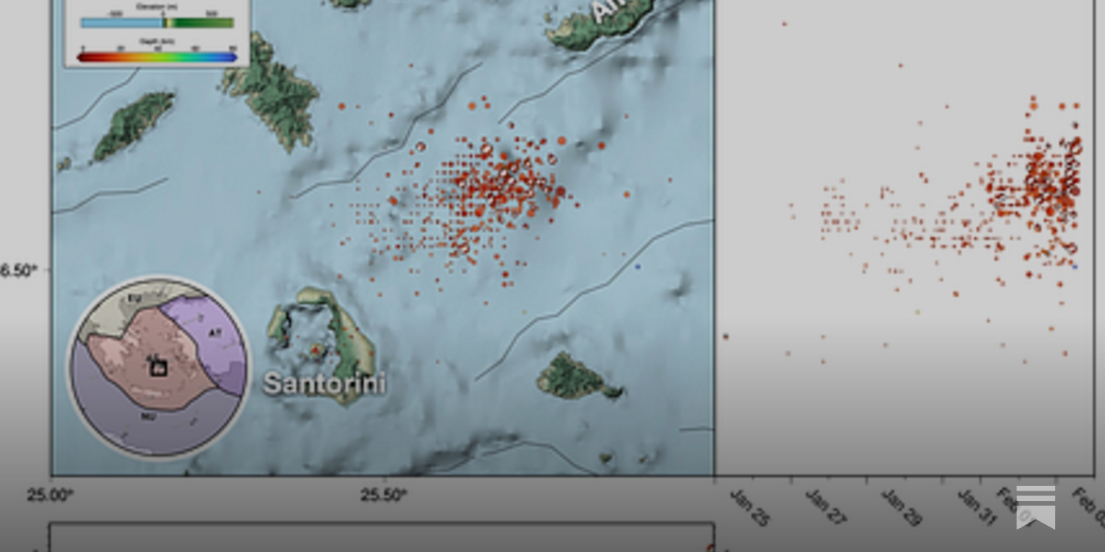
Schools will be closed Monday on the iconic Greek island of Santorini after a series of 200 earthquakes shook the popular tourist destination in recent days.
The region of #Santorini #Greece has been experiencing significant seismic activity over the past few days, here is the time history.

holy
Majority of these are weaker and probably didn't do too much damage (upper limit of around M4.5 so far, majority sub M3.0), but there is concern that it may be a sign of somethin else about to happen (either a larger quake, or a volcanic eruption- although the underlying consensus is probably not volcanic related)
But for either scenario- a tsunami would probably be the greatest concern if something happened
tl;dr- Weird thing happening- everyone's sorta watching in case it is a sign of something worse- could very much end up fizzling out as well- no one's sure. Just a notable oddity atm
Will say though- attempting to use my version of GlobalQuake is near impossible unless I start filtering (Image #1- The last 1,000 earthquakes world wide (aka- no filtering)
#2- Limited to the last 48 hours
#3- Limited to the past 5. (Still a little cluttered!)
Might have to turn old quakes off for a bit


yeah I'm interested to see if it's a precursor or just fades
Greek government is responding to elevated risk of large earthquake
Upper limit is seems to be upto 5.1 now
https://earthquake.usgs.gov/earthquakes/eventpage/us7000pb0e/executive
Edit: 5.3 now
https://earthquake.usgs.gov/earthquakes/eventpage/us7000pb82/executive
NASA's Near-Earth Object (NEO) web-site. Data related to Earth impact risk, close-approaches, and much more.
Newly discovered Tunguska like asteroid has a currently estimated 1.3% chance of hitting earth in 2032
more info: https://en.wikipedia.org/wiki/2024_YR4

2024 YR4 is an asteroid between 40 and 100 metres (130 and 330 ft) in diameter, classified as an Apollo-type (Earth-crossing) near-Earth object. It was discovered by the Chilean station of the Asteroid Terrestrial-impact Last Alert System (ATLAS) on 27 December 2024. As of 4 February 2025, 2024 YR4 was rated 3 on the Torino scale with a 1 in 63 ...
impact risk corridor

important note: this is preliminary calculations, the asteroid is currently moving away from earth. more precise estimates will be available when it comes back. This is what happened in 2004 with apophis. back then the initial estimate was a 2.7% chance of it hitting earth, and it has since been downgraded to zero chance. In other words, dont panic yet
So just fyi for the purposes of data - NOAA has been breached by Musk and his wrecking crew
Presently, climate.gov is still up, but is likely in danger. Get whatever data you need sooner rather than later. I don’t know who has been archiving or saving the data from that website.

A look at earthquake patterns beneath the Aegean Sea
FYI - get your data before it disappears

WIRED
Sources tell WIRED that NOAA employees were ordered to give an engineer from Elon Musk’s DOGE task force access to all of the agency’s Google sites by the end of business on Wednesday.

New lil graphic on the side there- "Most Probable Peak Intensity"


News video from water managers in CA about Trumps water release and the damage done https://www.threads.net/@carm1215/post/DFvrj6lyfHg?xmt=AQGzpVwFBfpLTlFPfteZBe-IrtSRy457SBo-8DuA5O1yyw

Threads
No one in the WH ever does any homework 😡 Central CA is screwed for this summer's harvest.
space agencies raised it to 2.1%
https://earthquake.usgs.gov/earthquakes/eventpage/us7000pcdl/
7.6 near the Cayman islands
No real human impacts expected for this one- occurred in the ocean, in a manor that didn't support tsunamis, a rare "peaceful" strong one imo.
sometimes the ocean just goes boom
Every once in a while, the Universe likes to remind us it has the ability to kill us
Good read about the asteroid.


@unborn timber taking a peek at the GlobalQuake livestream and dang theres plenty near Greece rn
yup, still goin on lol
For some reason theres plenty in west Tx too :/


Getting ready for the snow storm here in Toronto
We might get a little fucked (scientific term) in the mountains here too btw- parts of KY already had record (daily) rainfall rates yesterday, some areas may also get packed w/ either more rain or snow (depends how north you get.)
it's valley life- we just avoid the low bits and hope no rocks start sliding 🤠 (Most of my local area is more elevated than the river, buuut a few houses/ areas consistently get flooded every couple years)
i am doin my thing in the other servers as usual
This is actually a more "recent" hypothesis (like paper published 2023/2024) from a few people who I somewhat have talked to before!
Nudger events!
(storm gets behind another storm's hook echo- "bumps" the "important storm" forwards into it's own inflow, storm starts wrappin up real quickly and tends to produce a tornado)
https://fxtwitter.com/CameronJNixon/status/1781364309215281461
(old gif for example)

I advocate for the recognition of "nudgers" as important for tornadogenesis*. Nudgers are cells that don't merge, but can "nudge" the RFD for long periods of time. Have you seen them?
*for reasons discussed in https://www.spc.noaa.gov/publications/broyles/tgen1.pdf and https://journals.ametsoc.org/view/journals/mwre/151/1/MWR-D-22-0026.1.xml
Pretty intense thunderstorm passed by and woke up to it banging at my house this morninghttps://x.com/iembot_fwd/status/1889681216342991158
Strong thunderstorms will impact portions of Robertson, east central Milam and Leon Counties through 915 AM CST [wind: 40 MPH, hail: 0.50 IN] https://t.co/KieO0XOr7K

There's actually 2 tornado watches issued rn (more "broad" of a warning- "this area may see higher than average chances for a tornado"- which then will be given a tornado warning within said watch)


70/60 on that 2nd one is certainly 👀
Yeah, prolly about to get some tornados in MS- we're a tiny bit ahead of the expected "start time" and there's already a cell churnin


Tibbie aint never do me wrong i tell ya- if you ever wanna chase Dixie head towards that area I promise ya. it'll be the best worst experience in your life.
(Nothin but TREES in that area.)
Oooh that is a mighty tight velocity couplet, I'd be amazed if this doesn't produce something.


. .pockets of rotations I'm watching off this one radar.
Fracking?
Fracking or not (basically guaranteed that), its weird seeing a spike in the middle of an otherwise stable area
Well that’s why I suggested fracking. Also possible injection wells for waste. Fractracker is a good source for identifying possible oil and gas operations locations
At the same time, im more worried about the shenanigans off Greece at the moment

Likely a strong if not violent tornado just S of Coffeeville, AL now.


PDS issued for this one

Saturday discussion.


Leaning more towards a damaging straight-line event, but tornado risk is also noted.

ABC7 Los Angeles
How much rain is expected in Los Angeles? The biggest storm of the season could bring several inches of rain Thursday as the region braces for flooding and possible debris flows.
Excessive Rainfall outlook for Saturday


We may be looking at another notable if not historic flooding event for the Appalachians (Details to be fleshed out over the next few days as confidence in the model runs grow.)
Will it be 10-12 ft bad like in 2020? Prolly not, but flash flooding on a smaller scale could still be quite damaging for the local areas.
My main concern is how sudden it may get flooded, in 2020 it was a real damn slow creep over the prior weeks.
Prelim M5.9 Earthquake south of Alaska Feb-13 23:59 UTC, updates https://t.co/u7SvpqOBqh


Light earthquake in Cali to follow up.
That's not good (Greece)

Consistent shaking now, certainly a change in the "event" type.
New data reveal unexpected volcano-tectonic interactions


Daily rainfall totals for Central KY and TN (3 hours old)

more funny but this dude got ripped into immediately


I'm going to be out, helping local areas, flooding quick here
I'd wager the rivers already up 6-7 ft
Take care and don't do anything stupid
Some of the inlets for the Cumberland River have reversed the river flooding into them I have never seen the water this fast
We're still at an estimated 6 maybe 7 ft for the Cumberland River yeah
Omg wow
There's debris in the river, small stuff like a child's playground slide, ice coolers, small stuff like that
This is TN?
Southern KY
Got it
Appalachia
What Palt said.


I'm not an expert but I would say that the level of moisture is a bit higher than it should.
Had to hitchhike home, 23.5 ft crest at the moment, forecasted to get around 31-32 dt
Will head back out tomorrow
No structural damage seen this trip, saw one capsized boat (looked to still be partially attached to a trailer), and a fair bit of "light debris" in the river (ex. Ice coolers, plastic playground slides, tree trunks, etc)
So someone lost shit, but not their entire house/ mobile home it seems
Back in 2020 we had entire mobile homes get washed out, real nasty scene, think we had like 10-15 deaths that event. (Around a 30 ft crest back then too.)

some areas are already past their predictions

How’d things go overnight?
I was asleep in pure ache pains, checking on this new
28 ft now. expected to still creep up to 31/32 for my local area,

JUST IN: At least 8 people dead after floods in Kentucky, governor says
This is what you're met with if you try to access the NOAA Radar Next Program info PDF...
but I was told that NOAA wouldn't be affected

File is at https://www.noaa.gov/sites/default/files/2024-01/NOAA_Radar_Next-Radar_Next_Program_242901.pdf if you want to see it yourself.

Wow! Likely tornado damage from last evening’s storms south of Bradford TN. We were close by and the storms were moving so quickly… at times 65mph
so google maps updated their Los Angeles satellite view..

Updated my mapping, still so much to do- All new additions in blue.

close zoom on the elephant in the room, wrote off the entire stretch of land.


YR4 impact risk is still climbing, currently at 1/35. JWST is set to observe it in infrared light in early march and a second time in May, enabling scientists to more accuratly measure it's size and it's temperature as it moves away from the sun. We wont have accurate prediction results til then.
source: https://blogs.esa.int/rocketscience/2025/02/10/james-webb-space-telescope-will-study-asteroid-2024-yr4/
(Photos were taken yesterday)
Water's risen another couple of ft, est 30/31 atm, it's gonna hold at this height for a day or two and slowly recede, but it's currently snowing here
Starting to recede! around 27-28 ft, will continue to lower over the next few days, got some nice snow pics i'll export soon ™️
Stay safe out there. This vid from Detroit is wild
https://www.vxreddit.com/r/mildlyinfuriating/s/EQtgxiIp4F

holy shit the way my mood CHANGED when i saw how high this was
What the…..?!
Yes I know right? Insane
Did it rain…..? Or did something back up?
Heard something backed up, + freezing temps caused all this
Saw a claim that it is more likely to hit the moon now. I have not had a chance to source that claim - if anyone has info, that would be appreciated
earlier it was said that it had 1.2% probability of hitting the moon but I assume that's been since changed with additional observations
you can find up to date data and history plots for each near earth object here: https://neo.ssa.esa.int/risk-list
NEO
if you're seeing impact probability for hitting the moon, do tell me where to find it

Shallow crustal faulting above the Cascadia subduction zone


My personal take on the next several weeks, going into the early-mid spring.
Early March cold then the Eastern Hem MJO orbit + -EAMT next week triggers a sudden transition to spring mid-March.
I suspect after that the -NAO tries to make a come back near the tail end of March into early April w/ the -PNA & Scandinavian ridge returning & a weste...
Tldr: Weather nerds I respect very dearly are noticing a close resemblance in the overall weather pattern (that is currently forecasted) as the 2011 tornado season.
(which, yes- did have the Super Outbreak in the southern USA, but a majority of the tornado setups were rain wrapped blobs of mess, including tornadoes such as the Joplin EF5)
Last night around 2:09am EDT, there was possibly a significant tornado northeast of Numeralla, New South Wales, Australia. Radar showed a defined hook echo and possible debris ball with a very strong velocity signature over a rural forested area. Will have to await sat imagery.

Reminder- spins the other way across the equator.

ah, right. I almost forgot :P
Fascinating
I am now hearing from multiple folks in the past two hours (including some who have personally been fired) that mass firings have now commenced within NOAA--including, yes, at the National Weather Service.
Also if we gut the NWS over here- hopefully EU steps up, there'd be a mighty fine pool of scientists....
it's going great in other servers right now 🙃
(Most of my stormchasing/ weather discords have a no politics rule but that is way out of the window, everyone's pissed off at this)

Like, this is what the NWS provides for "free" (read slightly lower)- they want $8 a month for it, ($80 a year price atm, 21.9178 cents a year)
NWS charges us like $3 a year in tax split. Effectively free (0.8219 cents a day, Accuweather wants to charge you 2,666.7% more than what the NWS does, for honestly not that much more.)

Accuweather's CEO is involved with Project 2025
btw fun note- if you want long range models, which are included in the next tier, Accuweather would effectively be upcharging you ($200 a year vs NOAA's like $3)
6,666.6666 (repeating) %
NEW: A National Weather Service employee tells me office credit cards have been limited to $1, preventing repair of equipment, travel, etc.
This may affect tornado damage surveys next Tuesday/Wednesday.
Reports are that we can expect another 800 NOAA cuts in the immediate future.
Storm season is coming fast for Tornado Alley, I don't wanna think about the implications
Looking at an event Tuesday, 🚬
Strong quake in western TX?

USGS has it marked as M2.6, probably under strict review as some TX seismic stations are quite scuffed. (But this triggered so many, including a few in OK, i'd be shocked if this remains marked as M2.6)
Across just the Plains states, these offices are “critically understaffed” and now require “mutual aid” from other NWS offices:
Cheyenne
Goodland
Jackson KY
Kansas City
Marquette
Omaha
Rapid City
Wichita
Denver
Sioux Falls
Grand Forks
how today's event looks like to me, personally.

i cri.
(Looks very favorable for some beautiful tornadoes today over the open plain, in pure flat terrain with limited risk to any civilization.)
(I have work tomorrow in KY,)

GuaranteedTornado.png
Lapse rates above 8. Storms will be great.

Great timing for tornado season 😒
NEW: The Trump admin has informed NOAA that two buildings that are critical for weather forecasting will have their leases canceled. If this comes to pass, it's a really big deal. Includes weather fcst nerve center in College Park, Md.: https://t.co/MAzRvzMLrZ
After working closely with DOGE and the Administration, I am thrilled to announce that common sense has prevailed, as the National Weather Center in Norman, the Social Security Administration Office in Lawton, and the Indian Health Services Office in Oklahoma City will remain
We're looking at a potential severe weather event on the 15th/16th.

I'll be more comfortable talking specifics in a few days if the models continue being consistent, but this current run certainly suggests a notable event.
(966mb low in fuckin Kansas wut)
^If that was over the Gulf, we'd likely be talking about a Cat 2 hurricane lmao


(Probably felt at around a 5-7 on the MMI scale for these poor guys, likely the only people who felt this one.)


We look at the fascinating setting of this event
So this is the first time we've had two 30% forecasts pop up within the same year (since like 2016 when this new system was introduced)
and they're back to back 30%'s- fun little stat there.


Very notable wording for 4 days out.

@Collins_Wx Geolocated video to 28°43'39"N 81°23'09"W facing WEST.
#flwx
(Had to omit the screenshot showing the downed street lamp.)
random strong FL tornado yesterday while Twitter was down lol, finally had a chance to pull the footage to geolocate this very close call a mail carrier (?) had.
...certainly will be watching to see how the AI models handle this, but first runs are a little insane (Specifically D5.)


Authored in part by NOAA scientists - this is originally from 2018 - https://journals.ametsoc.org/view/journals/amsm/59/1/amsmonographs-d-18-0020.1.xml

AMETSOC
Abstract Over the past 100 years, the collaborative effort of the international science community, including government weather services and the media, along with the associated proliferation of environmental observations, improved scientific understanding, and growth of technology, has radically transformed weather forecasting into an effective...

"A wildfire outbreak is possible"
That's some terminology I've not heard in a while
I don't think "red flag warning" quite covers how severe the risk is


Meanwhile in Nebraska: https://x.com/NWSOmaha/status/1899770343600042113
We're still looking at several potential weather hazards to end the week. Here are the main things to know.
For a more detailed breakdown, check out our latest briefing here: https://t.co/PbOHDmVbef
And for a detailed forecast for your location, check https://t.co/uYewUJgzE4.
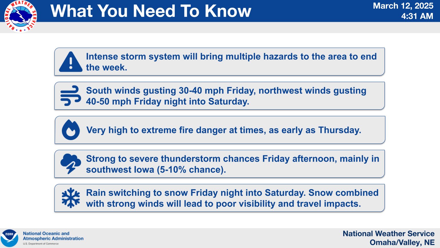
https://x.com/NWSLosAngeles/status/1900209996102615241
My superstition is flarin HARD rn
I always check for a random fuck off tornado west of the Rockies a day or two before the "big event"
usually there's always a fuck off tornado like this one.
there is absolutely no scientific backing to this hunch but it's never done me wrong so i'm in caveman mode.
CONFIRMED EF0 tornado occurred in Pico Rivera, CA (just W of the 605 fwy & Whittier Blvd) between 3am and 4am today. Preliminary details: wind speed 85 mph, length 1 mile, width 80 yards, duration 2 minutes. Exterior damage to homes and cars, multiple snapped trees #cawx #larain

I’m too curious: wdym by “big event”?
That’s way vague considering the context of weather
Earthquakes, a supercell, more tornadoes, hurricanes, there’s a lot of options
it's looking very likely that a very high end severe weather event will occur Friday-Saturday
with the big day being Saturday, overnight.
All hazards (significant wind gusts, large hail, and strong if not intense tornadoes. per the NWS's assessment of the event.)
We have not had such a widespread upper end severe weather event of this caliber for many years, (most of MS and AL under the gun here.)
Best of luck to those living over there
Potentially historic fire-weather conditions are likely Fri over the southern Great Plains.
Wind gusts to 60-80 mph, low RH and dry fuels could support numerous large wildfires.
Monitor the weather and all information from emergency officials. See https://t.co/QMmU4tBZDt

I’ll have to manage that tomorrow… dang. Hope everyone in that region stays safe
I'm in the Critical part, prarie goes up fast if and when it does

James Spann's Morning Briefing - Friday 3.14.25
James Spann talking about Alabama's severe weather risk for Fri-Sat,
He is most known for his coverage during the 4/27/11 super outbreak for the area.
IN THE EVENT that tomorrow ends up being very upper level for a major town/ city,
Probably will make one post in #usa-canada alerting everyone, but will keep most of the talking in here, as it likely would be a national/worldwide news event at that instance.
Today's risks, w/ closer zooms of the southern and northern risk areas for towns included. Everything within that black outline (which is the same outline as the 15% for tornadoes.) is hatching- aka indicating that there is atleast a 10% chance that a strong tornado could occur within this area. (SPECIFICALLY- w/in 25 miles of any given point.)
If you want to poke around in Google Earth like I do, you can pull the kml files from the NWS website. If you need help w/ pulling todays/tomorrows/ any historical event post 2002, lmk.


Mainly more confidence in the event verifying, unfortunately.
Straight-line Wind driven MDT for today, somewhat luckily for you, still could be mighty dangerous (ex- tree falling on a house), but overall tornado threat is on par with most typical past events- just keep updated, and if somethin starts looking iffy near you, take shelter and you'll likely be alright
The concern w/ tomorrow is that we may get the strength where (given a strong/ violent tornado hits them,) most people will not be able to survive unless they are in a very well built home/structure, or underground.
I am actually underground, basement apartment
Good deal- looks like mostly for you it'll be more of a general hinderance for your area luckily, you might have tree damage near ya, hail damage is possible, if you get both overlapping at the same time (timing is weird for some of these forecasted storms.) - could have some windows knocked out easily
@limber mesa YSK- that at that level, if people do start reporting wind gusts like 70+ MPH, you might have tornado sirens go off for that wind threat. Some people get caught off guard by that. Same principle though- take shelter, then you can check to see if it's tornadic or straight-line wind related.
yep, that's a thing that's happened before
I'll be at work, and I've been through this kind of thing before
it is wild for March though
It's unfortunately on par for Dixie, maybe a little early for the "big event", but it's Dixie season- I might be chasing in southern/ central KY, unsure how far north this event will try to fire tomorrow.
I can tell ya already i'm getting very little work done today.
there is one storm NE of Tulsa, OK that could spark a monumental wildfire, i can just about guantee you that many meterologists are watching that for the next few hours (until the severe weather threat up north.)

already gusting 70 MPH in some areas 👀


Satellite is showing the second round of dust for today. We are seeing gusts up to 70-80 mph across the region. #lubwx #txwx

For educational purposes only. If you live in the affected areas, please stay tuned to your local National Weather Service office for the most accurate and up-to-date information.
A significant severe weather outbreak is expected to begin today from the Midwest into the Southeast. SPC has outlined a Moderate Risk (level 4/5) for today for the t...
If you want the full details, hour long discussion.
There's currently a mass exodus of T-38s out of Columbus Air Force Base in Mississippi ahead of tomorrow's severe weather outbreak. #MSwx
12:32pm CDT #SPC Day2 Outlook High Risk: in central/southern parts of MS/AL https://t.co/Y1WiOd8m1i


This is only the 3rd time since at least 2006 (when we can easily query our records), and likely only the 3rd time in SPC history based on available data, that a High Risk has been issued on Day 2.
The 2 previous times were:
4/14/2012
4/7/2006
Governor Kay Ivey has issued a state of emergency for all 67 counties ahead of this weekend’s severe weather.
Governor Ivey also issued the following comment:
“The state of Alabama is at risk for potentially dangerous, severe weather throughout this weekend, so it is critical

So that hunch of yours was right I suppose

USA TODAY
Evidence of elevated volcanic activity indicate eruption of Alaska's Mount Spurr volcano could happen within weeks or months, federal officials say.


A closer look at some of the wreckage here on i-27.
Absolutely horrific scene
Canyon Texas
#txwx #wxtwitter @NWSAmarillo
What i would give to be a storm chaser
STORM-NET 3 hour Tornado probs (think of this as "% of certanity" of a tornado occuring somewhere here)

1 HR run is a lot of "eh" rn, so we're lookin a bit longer term here
very deadly hobby tbh-
mainly car crashes.
Mhm, it's perfect for me.

"Radar confirmed tornado"
PDS tornado watch issued.

btw- this was a decently strong one, had debris up to 10k feet above ground level- atleast one report of entrapment in a "collapsed home"- no further details on that one, mostly rural pathing.
Still waiting to get damage pics outa the Duncan MO tornado.
Tornado Warning continues for Rolla MO and Northwye MO until 8:15 PM CDT


Many strong tornadoes so far today
Saint Louis under the gun.
Tornado Warning continues for Oakville MO, Mehlville MO and Kirkwood MO until 9:45 PM CDT

The tornado as it crossed I-44 east bound in front of me and @RiskeChris near Villa Ridge, MO #mowx #wxtwitter


TOR-E issued for Van Buren.
Tornado Emergency including Van Buren MO and Fremont MO until 10:15 PM CDT

Major tornado damage in Cave City Arkansas. Went right thru middle of town. Lots of search and rescue ongoing. #arwx #tornado

... Just woke up, last night was very strong in terms of tornadoes
Large tornado south of West Plains, MO around 9:05pm. Damage blocking roads here. #mowx


The 2nd wave (3/15 at night) is expected to be higher in intensity.
Non-zero chance that intense tornado SW of the St. Louis Metro is, in fact, TWO tornadoes fujiwhara-ing around each other. Incredible data from KLSX NEXRAD


#StillwaterFire: Wildfire in Stillwater, Oklahoma
Fires have been reported also in Norman, Velma, Edmond, and Shawnee
#OKWildfires
#okwx
the car was muddy before it left the road. (Likely thrown off road, rolled, then thrown back across road.)

**GRAPHIC CONTENT- **injured horse seen in drone footage at 8:10
Tornado leads to fatalities in the Bakersfield area. Troop G has been severely impacted by tornados, thunderstorms, and large hail. The Bakersfield area in Ozark County reports multiple injuries and two confirmed fatalities: an adult male and an adult female.


Photos from Oil Trough in Independence county… that first photo was a steel I-beam anchored by 3 feet of concrete…
Horrible damage.
Photos from Levi Mcdougal
As my power went out I thought, "better check the weather post on discord"
.....oh yeah historic day ahead likely
had a very notable if not a generational event last night
Still a few towns w/ no updates from em which is concerning
Today's outlook


Im happy for you (?)
It's in the area I grew up in, so i'm highly on edge
I guess its one of those moment "im so thrilled, but also not..."
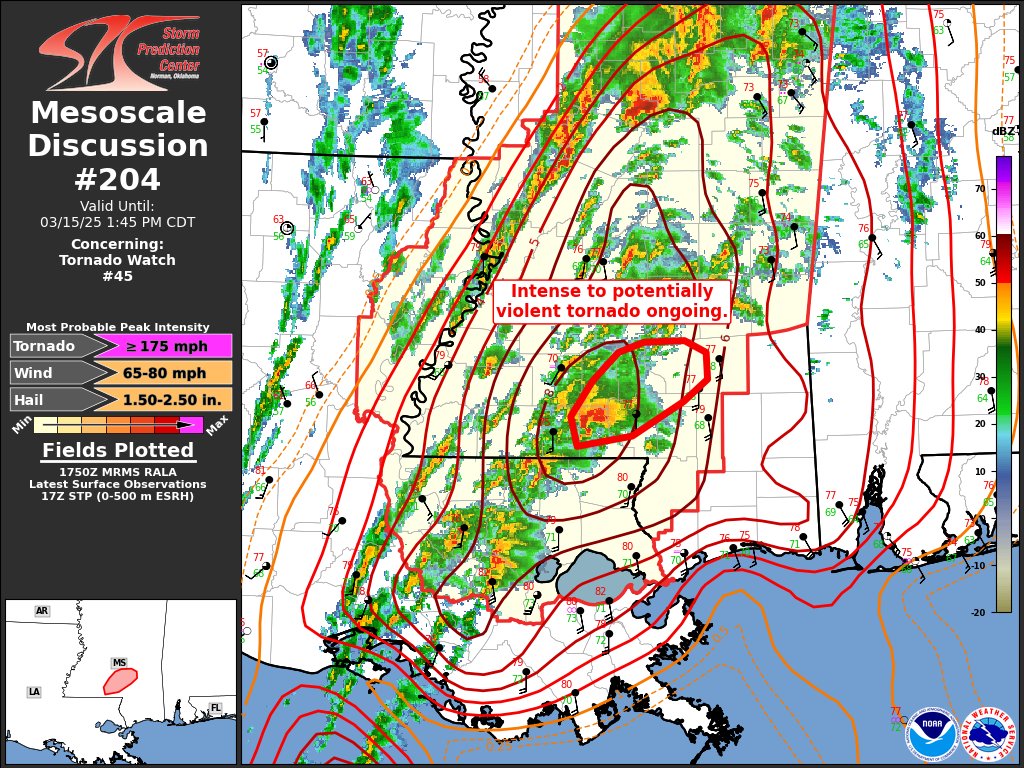
Key messages update for the outbreak of intense tornadoes expected today into tonight.

Wow. The morning weather balloon launch from Jackson, Mississippi shows a classic tornado outbreak look.
Meteorology majors – the atmosphere is going to be a textbook today.
Deep South residents – that's not good.

Tornado Warning continues for Lake Providence LA, Rolling Fork MS and Anguilla MS until 10:45 AM CDT


..... Very likely looking at a historic outbreak


Just had a possible tornado north of Winona, Mississippi as I was doing a little video update talking about today’s setup across Mississippi and Alabama.
#mswx #alwx
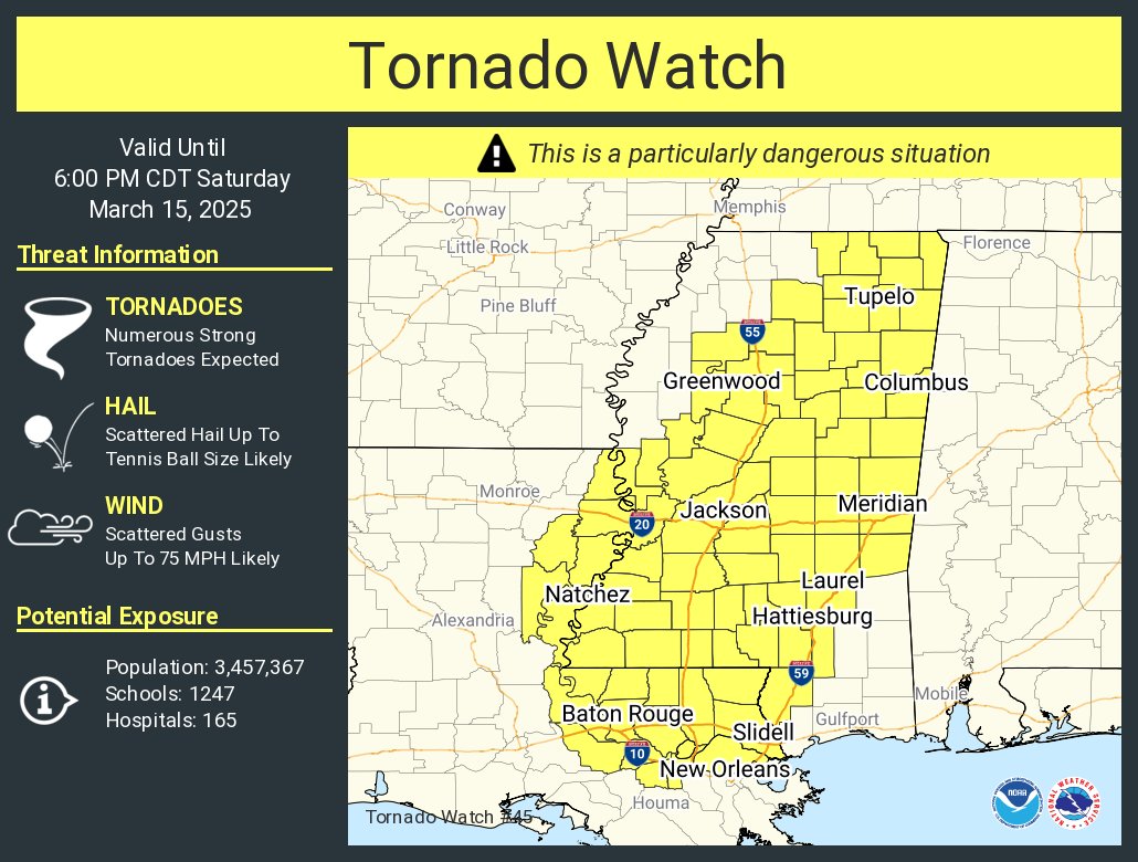
A tornado watch has been issued for parts of Louisiana and Mississippi until 6 PM CDT


That sandstorm managed to reach all the way here in DFW. I knew sand travels far but dang

Literally maxed out the Tornado threat for the watch
Was just boutta ping you and ask if you seen the TX sandstorm videos recently
Oh yeah the pileup in the panhandle was horrific.
Hope everyone survived

Guess this doesn’t happen often judging from how much focus you’re putting into this
" numerous tornadoes are expected, including the potential for multiple intense to violent tornadoes (EF3-4+)"...
Well dang
3rd time in NWS history we've seen the 95/95 split for that.
1st time in my lifetime.

If everyone agrees “yo this shit gonna be SCARY”, it’s gonna be scary
And confirms that every single storm chaser with A N Y level of clout is gonna be there because of how rare this is
Hopin for this to bust out and do absolutely nothing
A couple were hit/ had incidents last night
One can hope but time holds the answer
Up to 16 fatalities from last night, mix of tornadoes, flooding, wind events, and wildfire.

SIGNIFICANT DAMAGE ON LIVE STREAM as Hunter encounters major debris on stream. @NWSStLouis @hunterhurleywx @ryanhallyall @MaxVelocityWX @BluekandyWX

Very strong tornado crossed the LA/MS state line, W of Tylertown, MS

Given a Tornado Emergency.

Salem, MS is likely to be hit by this one soon.
pink box is where Salem is


ABSOLUTE DISTRUCTION SOUTH OF TYLERTOWN ON HWY-98


Tylertown, MS DRIVER WALKED AWAY

Likely violent tornado damage from overnight in Diaz, Arkansas. Multiple homes leveled and slabbed, trees debarked, vehicles mangled, and debris wind rowed.
Source: https://www.facebook.com/JoshCoop/videos/1003351937791075 #ARwx

arrow one is still ongoing.


my path estimation of all 3.


Taylorsville in danger.

North of Bassfield, MS

Another strong one immediately.
Just the obvious tracks.

***Update** The tornado survey team has found damage in Cave City consistent with winds of 165 mph. This is the very top of the EF3 scale. #arwx
One of the tornadoes from last night, Prelim high end EF3.

Wow, look at the multi vortex structure on the Taylorsville, #Mississippi tornado seen here lofting debris & causing power flashes. #MSwx #severewx
📹: Max Loper (Facebook; link 🔗 below)
Pic of the tylertown tornado https://x.com/Coach_Nick87/status/1900977475292692722
Massive tornado in Tylertown, MS
@ReedTimmerUSA @NickLilja @PatrickWDAM

..There were 2 in the area 👉 👈 (about an hour apart.)
probably the longer tracked one (left)

Oh dang I hadn't realized there were two. Absolutely brutal for the town
pro tip- do not shelter next to a carpenter/ logging/ whoever would deal with 2x4's shop 👀
very strong tornado either skimmed (or missed- hopefully) Gordo, AL.


closer zoom- timestamps are MM:SS in Zulu time.

Likely died out- Full pathing of the Gordo tornado-
(The more "?"- the less likely I am [using the data available] that the tornado is active at that time.)


Not a loop! Two tornadoes going over the same area twice with 40 minutes of each other. Geez #tornado #mswx
@severe kernel gif showing both the tornadoes in that area- check that timestamp 😅
About 40 minutes apart- first one was still ongoing (was about to die out)
Tornado barely missing the Birmingham AL radar


Talladega, AL got a scare,

Very brief (but still probably strong) tornado juust NE of Winterboro, AL.

ohkay night time significants okay (NW of Montgomery.)


With recent convection evolution across S AL and the development of another confluence band ahead of the main band of convection, a favored region of discrete supercells is likely across S AL. A dangerous situation appears to be unfolding in this area.

What are the chances? Same homes in Paragould, AR. Two tornadoes in less than one year. Crazy.
ASTONISHING data from this tornado in Alabama! It's just about perfectly between two radars!
KMXX in purple, KBMX in green.
Montgomery might have barely caught the first frame,
Tornado would have started sometime between 02:33:29 (wasn't seen in prior KBMX scan.) and** 02:34:23 **(first scan seen via KMXX

54 second window where this tornado could have started!
Unbelievable dataset!
I have THREE tracks mapped that were able to be tracked via two different radars! Northern two are KBMX and KMXX overlaps, Southern one is a KEOX and KMXX overlap!
This is an astonishing dataset!
#alwx


..i wouldn't be against the event winding down right about now...
..i have a lot of data to sort through already 👉 👈
literally about 8 hours of data from 7 radars, so.... rough guess, upper limit of 54 hours worth of data.
Likely closer to like 25-30 because i wasn't pulling from all for the entire 8 hours
Prolly pulled from KDGX (Jackson, MS) for 6 hours straight there..
but all of the tornadoes I MANUALLY mapped today! (In order- all MS, NW AL, then the rest of AL.)
Red ones are a part of the overlap dataset!
(There's likely many I missed!)


i will finally slep. 
If you would like to read from the start of the event (3/15/2025) go here.
1:46 AM update- my power just went out lmao that's a sign to sleep.


Preliminary 190 MPH EF4 👀
"a well built home (read: UB) was completely destroyed (read: DOD8+) "

This is what likely got the preliminary 190 MPH EF4 rating...
inb4 downgraded to 170 MPH EF4 due to debris induced failure.
Tree got shotputted through their front foor.

Calera EF1 vs where NWS BMX's office is. (Birmingham)
They had to take shelter and a neighboring NWS office took over issuing warnings for a bit.
Passed about 2 miles to their east,


what
literally we are three days out and there's a Winter Storm Watch for the area

So far we know between March 14–16, 2025, at least 56 tornadoes touched down across 10 states, causing widespread devastation. Over 40 people lost their lives, with more than 170 injured.
This March 2025 tornado outbreak ranks as one of the deadliest severe weather events in https://t.co/96M67CrSh0

per https://www.facebook.com/daniela.dehaghani/videos/8677361872364824 at around 1:20 in-
"they haven't been able to find the plane"
See posts, photos and more on Facebook.
There is apparently a missing small aircraft at the house w/ a prelim 190 MPH rating.
0:15 "The owner had a.. plane actually right there just for his hobby... all of that is gone aswell"
1:04 "He said the plane that he had- so this was kinda the runway... they haven't been able to find the plane so..."
gonna* horrific typo before forwarding. :C
Something weird happened at this property, (presumed) missing plane, one of the cleanest rootballings i've ever seen, and the upper level vehicle damage that isn't quite pulping the darn thing.


@Acedog112 Just realized I never responded. Here’s what he told me:
“My grandfather is a pilot and has had planes his whole life. Some out at the airport and some at his house. He has an airplane hanger next to his house and a grass runway there as well. What was destroyed/missing was a
I think I will stay at Home.

I feel the same

There's been another stormchaser death today, unknown cause of death- medical related.
He was chasing a few days ago too, complete shock to the field atm, young kid, I think early/mid 20's.

Here's the latest on the incoming Blizzard. If don't NEED to travel tomorrow - Stay Home!
For more details see https://www.weather.gov/media/oax/DssPacket.pdf https://t.co/y3oA3KdVnT
some possible thundersnow? that would be wild
Non-zero chance this is my last post in here (for atleast a while.)
Long story, heading north. Will likely be off the grid for a week+, hopefully not longer than a month.
Edit: plans on hold for a lil bit 🙃
Snowfall rate just got measured at 2.3in/hr here
Tornado Warning continues for Canton IL, Farmington IL and Lewistown IL until 3:00 PM CDT

One location in western Covington County just north of Spring Hill School Road was struck twice by tornadoes just 41 minutes apart this past Saturday afternoon.
The first tornado was more narrow as it approached the end of its path. The next storm that followed was wider.


map from wikipedia editor wxtrackercody of the tornado outbreak last week
112 tornadoes confirmed
Tornado Warning continues for Rolling Fork MS and Anguilla MS until 8:15 PM CDT

CONFIRMED #tornado moving into Rolling Fork, Mississippi via HazCams: https://t.co/8YhZCdDV9o
This is a developing situation. Seek shelter NOW if Sharkey County, Miss.! @NWSJacksonMS @MyRadarWX

Rolling Fork was hit by an EF4 on March 24th, 2023 btw.
Just about the 2 year anniversary.


BREAKING: At least 12 people killed in South Korea wildfires
💬 7 🔁 9 ❤️ 33 👁️ 1.2K

Pretty rare Washington/Oregon tornado risk,
I think the first time they've had a 5%

(Ignore the graphic breaking- no satellite coverage of the ocean from this specific one the NWS uses for this one.)
but 80% likely to have a (likely TSTM) watch issued
A severe thunderstorm watch has been issued for parts of Oregon and Washington until 9 PM PDT

Just had a fascinating conversation with a Korean reporter. The area that burned was intensively logged by the Japanese in the 30s and 40s. It has since regrown into dense even aged stands of conifers. Super dense stands that are impossible to walk through. There is no logging.
Michael Wara (@michaelwara.bsky.social)
Just got my first outreach from a reporter from South Korea to talk about the fires that are happening there. What strikes me about them is that this may be a preview into what will happen in the northeastern US as climate warms. And there is a lot of knowledge to apply from places like CA.
https://earthquake.usgs.gov/earthquakes/eventpage/us7000pn9s/executive
Separate thread for this one?
Usually we go for a separate thread if there is a large number of posts, especially when in a short time, and they are drowning out other conversations.
Heavy damage at Naypyidaw International Airport near Myanmar's capital. The air traffic control tower collapsed, killing at least 5. Runway damaged.

The aftermath/ political side of things (given that this country was in an open state of public unrest not that long ago) will probably need one when we get there.
The rates of ground liquefaction* were probably insane given how close the epicenter was
There are also some posts in #asia-pacific


LIGHT GRAPHIC CONTENT Injury is extremely likely seen occuring in the footage, obscured immediately by water.
"People get swept away by water from a rooftop pool in Yunnan, China"
||https://twitter.com/BNODesk/status/1905589597821624563?t=cBpOhk4XvcBWCEtF222yoA&s=19||
Being safe because it's not impossible a fatality could have occurred here. (Particularly from the unlucky few directly under the thing before it started spreading, they likely got the full brunt of it to their upper body forcing them down into the pavement.)

Follow updates live on BBC News here: https://www.bbc.co.uk/news/live/ce8jy9j91y5t #Myanmar #Earthquake #BBCNews
For the earthquake 👉 #1355158595800404221
Looking at a very active week in terms of severe weather.
(D1, D2)


D4, D5
(D3 is a bit eh imo, but some people are lookin at it at bein a sleeper event.)


if i had a nickel for every time i was woken up from a nap today by an earthquake near Tonga, i'd have two nickels, which isn't a lot but i should really change the default alert noises in GlobalQuake
Everything above a M5.0 blares a massive siren w/ default noises. These occurred 3 hours apart, not that many people felt it, small tsunami warning. (That i think may already be cancelled.)


12:57am CDT #SPC Day1 Outlook High Risk: across parts of northeast Arkansas, far southeast Missouri, far southern Illinois, western Kentucky, western Tennessee and extreme northwest Mississippi https://t.co/TgJgC6cj9Y


Newly available high-resolution satellite imagery collected by Maxar reveals sections of the surface rupture near the zone of maximum surface displacement of last week’s Mw 7.7 earthquake in Myanmar. Rupture is ~500 km long, with up to 5 meters of fault slip.
💬 2 🔁 93 ❤️ 264 👁️ 10.5K


Strong tornado near Old Mines, Missouri

Likely lifted- most of it's lifespan was over pure rural areas, a few structures may have been hit, today's likely going to be a long day.
eta 30-60 minutes and western TN is likely going to be very chaotic.


Video: Tornado on the ground north of Potosi, Missouri. #mowx
💬 1 🔁 12 ❤️ 23 👁️ 555
A tornado may have hit southern Greenville, IL. On route for Smithboro, IL.

Greenville, IL on the way to shelter 5:16pm
@ryanhallyall #yallsquad @MaxVelocityWX


All tornado warnings currently
Likely strong tornado on route to the Harrisburg, AR area.


Likely intense tornado near Mcgee, MO.

Bay, AR.


Free Live 24/7 Weather Radar And Alerts: https://www.youtube.com/live/SFcykaD6g0M
🔔 SUBSCRIBE and turn on notifications to stay informed about developing weather situations!
⚠️ PLEASE NOTE: This video is meant to supplement official forecasts from the National Weather Service. Always follow forecasts and warnings from local officials.
...
Very violent tornado ongoing
Tornado Emergency issued for Lake City, AR, Monette, AR, etc.


Storm Chasing & Live Streaming costs are extensive, I am able to keep my Live Streams free to the public thanks to supporters like you! Interested in donating to help support the extensive cost to keep these live streams free? All support big or small is GREATLY appreciated!
Paypal: https://www.paypal.com/donate/?business=V6DE62DSTJ3L2
Venmo: ...
Likely hit 35.83383208843391, -90.4631669594216 (Delta Farms, NW of Lake City, AR.)
This will be close to Monette, AR.


🇺🇸 A huge wedge tornado is currently striking Caraway, Arkansas! Take cover now!
︀︀This deadly tornado poses an immediate danger.
︀︀#arwx #Tornado
❤️ 1 👁️ 3
Looks like most of Monette missed- may have skimmed the northern side of town.


horizontal vortex! This one was insanely violent!
Indianapolis tornado marked as confirmed

Acedog I wanted to let you know that I check this thread more often than I check the weather broadcast.
Paducah's in trouble.

Due to how close it is to the radar (and NWS office) it is insanely hard to see.
but it's tracking directly over the office soon if not now
Just a followup- I sometimes sleep :c if you're in the USA i always highly recommend following your local NWS office on Twitter, (and if you don't know what your local NWS office would be, go to https://www.spc.noaa.gov/products/outlook/, and at the top left, type in your zip code)- They're the guys focused on your specific area and will alert you to stuff much faster than I can
Someone got a good frame- yeah that's a decent CC drop

NWS Paducah is confirmed safe, out of their shelter now, tornado likely missed to the south.
Likely a very brief tornado in extreme north east Indianapolis, near Carmel. (Likely very weak.)

Even better, I follow them on Bluesky
(Not all have moved to Bluesky yet i think 👉 👈 there's a lot of em)
We're all good here at the office, the circulation JUST missed us to the south, might have hit the airport, too dark to tell. We did lose power and we are on generator power. Be safe y'all!!!
Oh whoops mine is unofficial. https://bsky.app/profile/day.nws-bot.us
Unofficial bot sharing alerts from NWS Wilmington OH (including Dayton and the surrounding areas).
This account is not monitored. Contact @wandrme.paxex.aero if needed.
imo the event should slowly start winding down now if I remember right. 🤞
Very hectic day, likely had a couple of strong if not violent tornadoes (primarily over AR, who cannot catch a break lately.)
....southern Arkansas.... stop it.

high qual of this tornado near Jonesboro, AR (at roughly the same time- likely the same horizontal vortex seen wrapping around the front.)
This is very likely one of the strongest tornadoes we've seen in recent history.
..please can this event stop.
NW of Palmersville, TN, heading into KY.

#1's lifting, it's cycling to the east (red square is just to the west of the couplet+ new inflow channel for the top two squares), puts Bell City KY at risk.

Welp- Big time tornado likely just missed Bell City, KY.
Just went PDS.

Likely lifted juuust before it got to Murray, KY, might have some light debris fallout in the SW side of town (branches, etc.)
I don't know that my area is going to be out of tornado watch/warning action until 1 am Eastern 

The wall of a warehouse in Brownsburg, Indiana has collapsed after a possible tornado made its way through the area. We are hearing reports that someone people were unaccounted for. We have a crew on the way.
︀︀
︀︀#inwx
💬 22 🔁 96 ❤️ 346 👁️ 43.0K

Tornado on the ground in Carmel, Indiana, a suburb north of Indianapolis.
🔁 4 ❤️ 15 👁️ 1.9K
red- 1(+?) injured, rescued. Unknown on fatalities/ additional injuries.


But I'd wager that a lot of this relatively higher end damage is debris induced, using debris from the mechanics to the W side of the road.
i will now lie down, i will prolly be back if there's another strong nado or something but ahhhhhhhg i've been staring at radars for 10 hours.

... Likely had a decently strong tornado just start doing damage as it left the main Louisville KY area.
OLD Apparently there was another strong one in TN last night
https://x.com/ryanhallyall/status/1907680646996066807?t=sYwhrwsvXK6sByB90NU9Hw&s=19
Tornado Emergency continues for Moscow TN, Williston TN and Grand Junction TN until 2:00 AM CDT. This is a LIFE THREATENING SITUATION, SEEK SHELTER!
We’re tracking this LIVE now: https://t.co/jQ9l4nhe4x


We had 728 severe and tornado warnings combined, making yesterday the most active day of warnings since April 2011.

@unborn timber didn’t you mention how “this year looks like it’ll be a 2011 repeat”?
Well, i parroted it
Typed “mention” using the noun definition (in reference to someone or something), but even then, I hope nothing like Joplin happens again
Just for comparison btw- despite how big yesterday's event was, in terms of (specifically) tornado warnings, does not hold a candle to peak 2011.

it was certainly UP THERE, but yeah, fair difference
Remember my crackpot theory of "if a random tornado occurs W of the Rockies, the upcoming event will be notable" sorta idea?

There was a brief EF0 in California the day prior.
I do feel like there's a tie here,
We are early in the season though?
Decently, but Feb-Mar-Apr-May are typical dixie ally tornado months
(Like peak tornado season for that area)
It is weird how AR specifically has been getting hammered over and over, tomorrow may go HIGH aswell... over AR.
NWS Paducah in red. Passed about a mile to their south.


Strong/ violent tornado in TX, near Grand Saline
- Clarksville, TX

PDS'ed for Clarksville

A tornado watch has been issued for parts of Arkansas and Oklahoma until 9 PM CDT

very small watch (3 counties.), 50/30 tornado probs
This is the prelude to today's main event, primarily over AR when these storms track over that way.
Idabel, OK under a PDS tornado warning- likely precautionary. Pure radar hole.

current watches.

This area was likely hit,

This is what 11 continuous days of severe weather look like on a map. 🤯
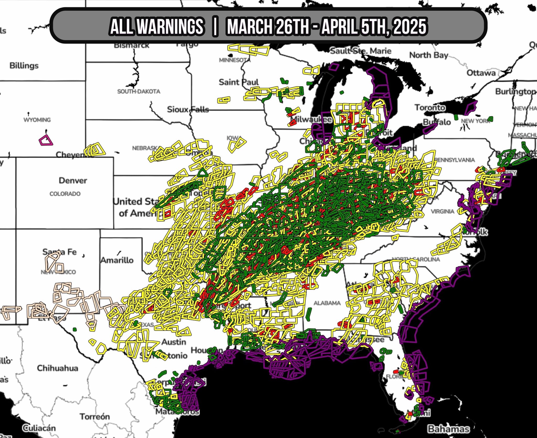
PDS tornado warning in MS, near New Albany.

structures very likely hit, going into New Albany, MS

Likely lifted just prior to the majorly populated area, far rural outskirts were likely hit however.

https://www.wkyt.com
“They think we’re about the biggest rednecks you can get, burying a van, but it is what it is, and we needed something to get out of the weather,” Hagan said. “That was the best we could do temporarily.”
I am unsure how well this would work.
I mean, possibly. Looks like they're not putting dirt on the roof, which would have ended their plans quickly
likely to have a negative climate effect if it goes into effect #1330709161385922650 message
After a hearty debate in other storm-focused channels,
the overall consensus is a mix of the following
"well... maybe?"
"Better than nothing"
"Weirdly.. possibly better than a mobile home"
It's mainly the dirt berm that's the lifesaver here, preventing wind from getting under the van to roll/lift it
...buuut if anything landed on the vehicle... it would likely be fatal.
I agree with that consensus
I sure wouldn't wanna be the one to test it as a tornado is coming
dome shaped homes though- would recommend.
looks ugly- but wind glances off it more often than a traditional house- this one survived a direct strike from an EF4 tornado, estimated at 200 MPH
(2011 Chickasha–Blanchard tornado)

Family survived inside- initially unaware of the tornado until it hit them
For comparison... nearby- rated 190 MPH.

This is actually one of the tornados that's lead to the push of lowering the EF5 threshold from 201+ MPH to 190+ MPH.
https://journals.ametsoc.org/view/journals/bams/aop/BAMS-D-24-0066.1/BAMS-D-24-0066.1.xml

AMETSOC
Abstract As of January 2025, the United States has gone over 11 years without the occurrence of a tornado rated EF5 on the Enhanced Fujita (EF) scale, constituting the longest “drought” in F5/EF5-rated tornadoes since the beginning of official records (1950). This article places the “drought” of 5-rated tornadoes in the context of a long...
Yes it is weird to see people I know (and have occasionally talked to) on Twitter listed w/in this paper.


I cannot tell you how much that storm missed Omaha

it's like the damn thing chose to go around
not a lot of rain, but big wind and hail
The event was just two cells, but oh boy did they speen.
Like 2 PDS warnings and 1 TOR-E (Tornado Emergency)
Team 1 finished our survey of the North Douglas-Southeast Washington County Tornado. Preliminary rating of EF-3. Significant damage was found to homes and buildings in the area.
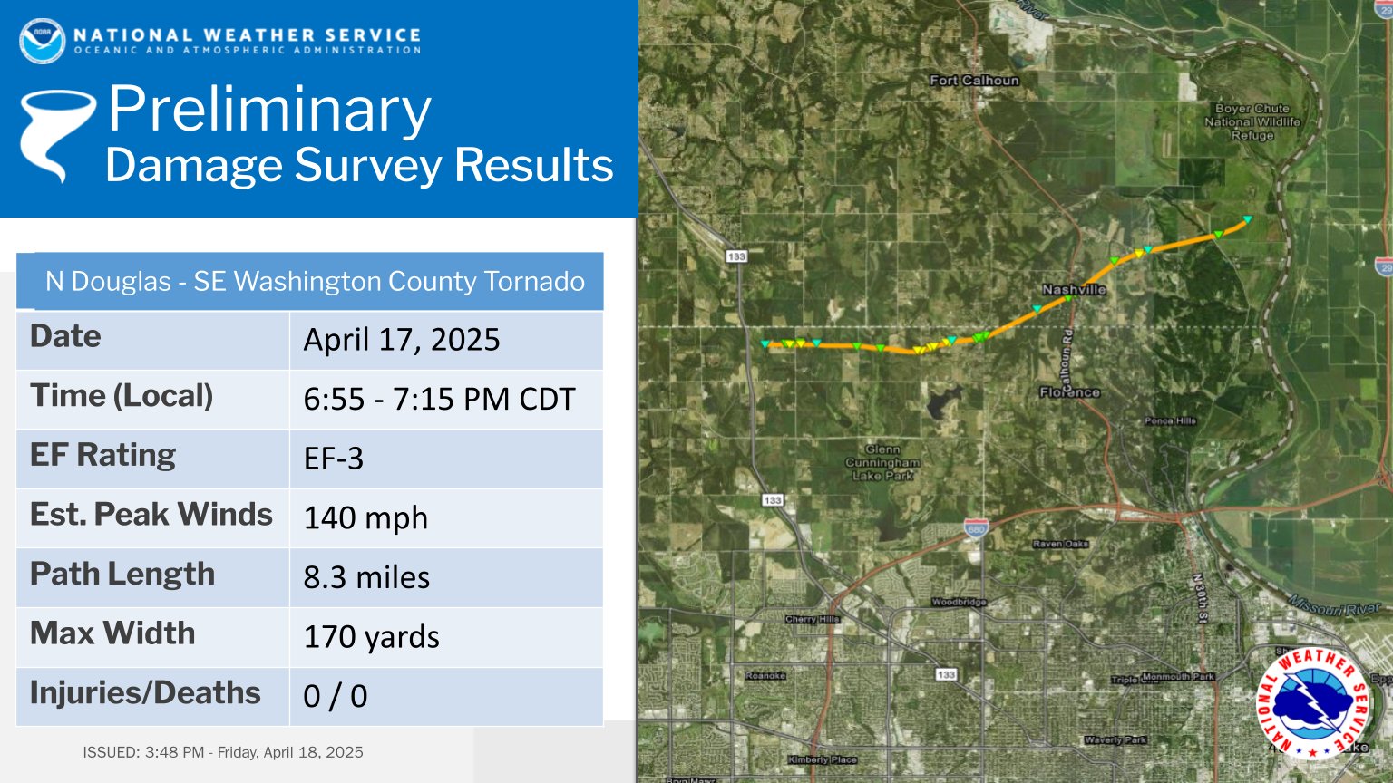

What I would give to be next to this beauty.
(Don't tell my fiancee I said that.)

What in the absolute fuck

That's a nado


... That's a STRONG tornado what in the absolute fuck was this cell development

20 minute difference. If I was chasing that woulda likely hit and killed me,


That was likely a very strong one. Baffled on what the fuck happened with that bubbler.
Low Precipitation tornado


Near invisible on radar due to very low rates of rain, only visible because it's picking up debris


@MaxVelocityWX Tornado from south of Stephenville * I did not take this just sharing!


Severe Thunderstorm Warning including Mertzon TX until 11:45 PM CDT. This destructive storm will contain wind gusts to 100 MPH!

Straight-line wind gusts up to 100 MPH for central TX, ouch.


Asbury Park Press
Local roads have been closed and evacuation orders both mandatory and voluntary have been put in place,

Update- nothing happened really, storm passed over, area's now in a flash flooding warning because of trailing storms

But someone did get this image

Approaching Matador, TX.

Tornado confirmed on this one.

PDS issued for this one, strong. Matador was hit not too long ago by a fairly strong one too,

Oklahoma,

The Freedom, OK tornado is likely active.

This is a very strong one!

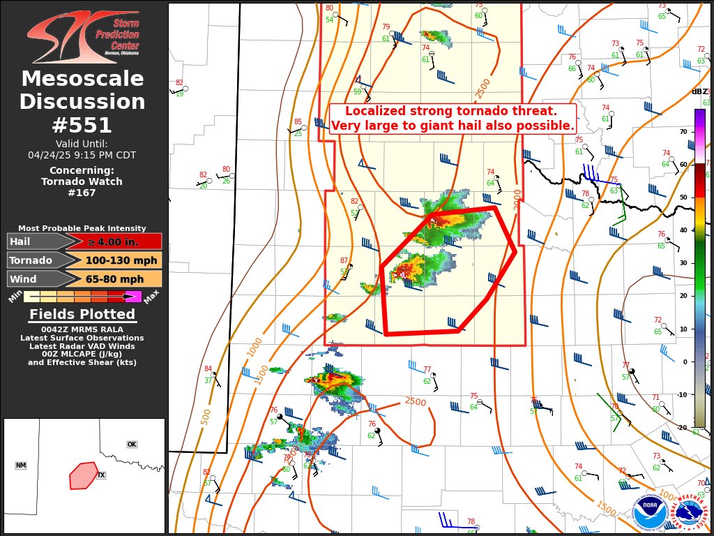
The NWS is watching these specific cells enough to where they've slightly upped the day's tornado probs specifically for them.
(Each image is a different forecast issued today.)
my area got missed, just had heavy rain

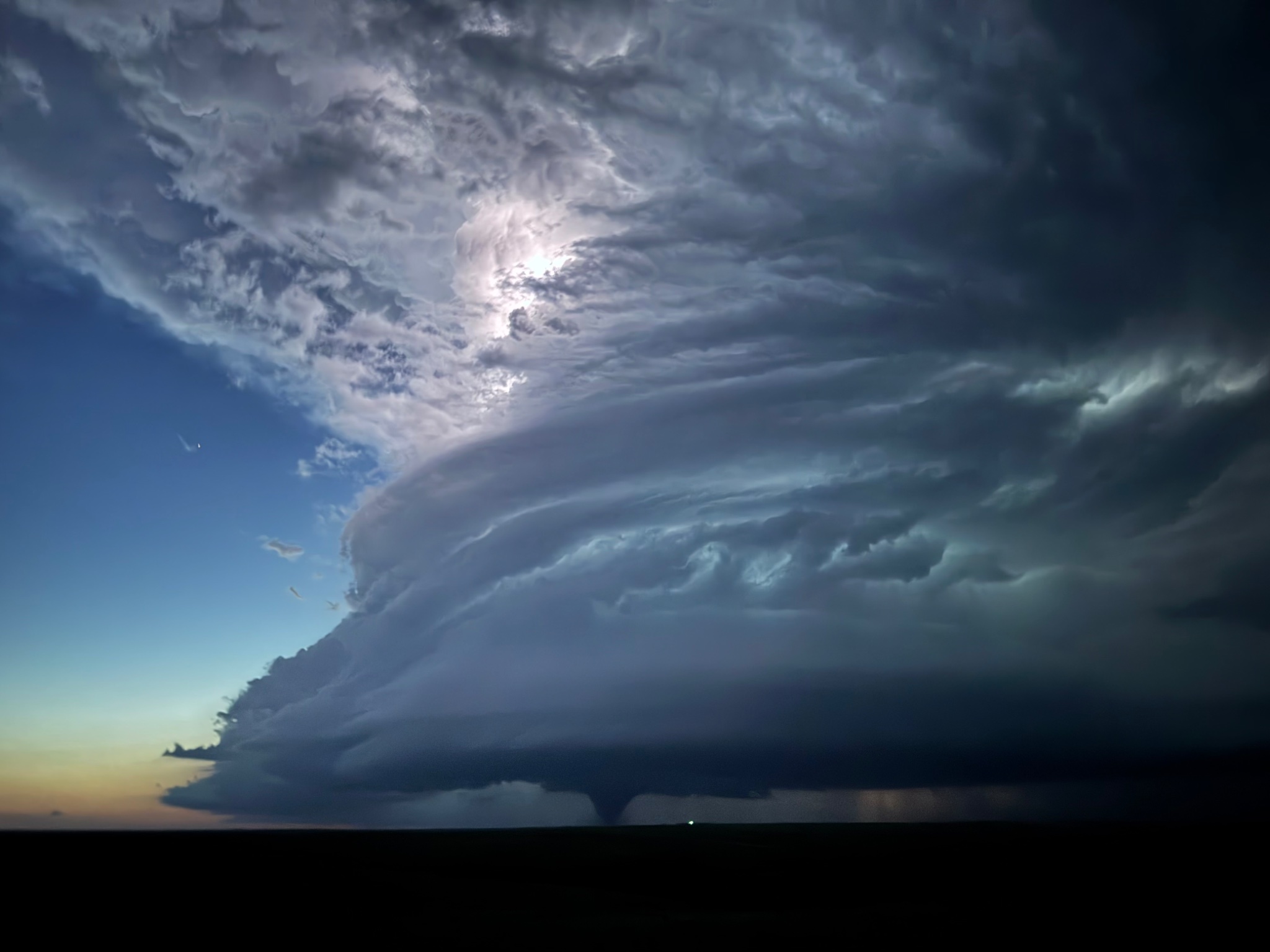

A friend called this in to me- reported that the clouds were "very slightly rotating"
I'm gonna mark this as OH and PA's first supercell of the year, 🥳


that is a large lad
You know my standard superstition, if a random tornado occurs W of the Rockies tonight/ tomorrow- I'd pay close attention to Monday's event.
Thx for the heads up 🙂
In my studies, the day before a notable tornado outbreak typically has a brief tornado in one of those states
There's absolutely nothing concrete about that hypothesis, but hey, 25% of meteorology is the same way.
(We are still a relatively new field of science.)
“25% of meteorology is the same way” hence why I’m not questioning your judgement
The day before a very notable outbreak (I believe last year) Alaska had their first tornado in decades, which really sparked my interest in exploring this pattern
You mentioned this to any meteorology groups, or is this a personal thing?
It's starting to gain a little steam in some other groups I'm in
Still starchly in the "internal data collection and peer review" sorta stage before we even dare to ask the NWS about it- because 60-80% of us are hobbyists, most without degrees (me included.) also not a good time to try and get in contact with them.
It is very funny how this field is very OSINT coded, there's a good chunk of data that is sourced from the public, and the data is open to the public in return. (This is probably why i've fallen perfectly inline w/ this server, primarily due to my geolocation background for tracking tornado damage.)
A rare example of a government operated OSINT-type operation working extremely well
Hype
I'm a smidgen outside the confirmation zone so I'll see what happens


Large stovepipe on the ground south of FT Sumner NM!! #nmwx #nwstornado
**👁️ 7 **
The storm system should probably be linear by the time it gets to Minneapolis, which in theory would kneecap hail+ strong tornado odds (but will increase weaker spinup odds),
may transition into more of a damaging straight-line wind event.
If the storms remain discrete, it would be a major issue for the entirety of central/ SE MN. (along w/ IA and a bit of WI.)
Current NWS forecast


Strong if not extremely violent tornado in Nebraska, https://x.com/NWStornado/status/1916647271954817071

Tornado Warning continues for Hyannis NE, Ashby NE and Bingham NE until 6:45 PM MDT

Train derailed on this one.

Derailed train + stripping of trees. This is easily a strong+ tornado.
︀︀
︀︀Photos: Severe Studios stream

Chasers had to flee from this one
https://fxtwitter.com/Collins_Wx/status/1916646088955592806

VIOLENT, WEDGE TORNADO ON THE GROUND ALONG HIGHWAY 2! BINGHAM & HYANNIS, BE RIGHT IN YOUR SAFE SPOT NOW!
︀︀
︀︀Storm chasers are fleeing, this thing is RAPIDLY GROWING!
︀︀
︀︀📸: John McKinney LIVE

Outlining each hook echo, second storm to the east is gonna try

Chasers calling that western one "easily a mile wide"

Likely died off now. Tornado was active for over an hour
The other storm however has also produced a tornado that is ongoing (population of about 0 people in its current path.)

VIDEO: BNSF train derailed by a large tornado near Bingham, NE. Crew is unharmed. #newx
︀︀🎥: Alyssa Criss
The third storm's starting to hook out,

This one might try to produce a few more

Merging of 3 supercells ongoing in the NE panhandle
︀︀
︀︀As I explain in all my talks, the merging of two or more supercells often results in a much larger storm, and is a common evolution preceding particularly wide mesocyclones (and tornadoes)

Wow

Not too well versed in reading radar but I spot a danger noodle
Fr tho, that’s… concerning
Ok how do radars know how fast something is?
Gonna try and get some sleep, keeping an eye on the Midwest for like 4-9 PM
Sleep well
Mainly got my eyes on around 6 PM for Minneapolis,
There's still notable ways that tomorrow could fail to do much, but if the conditions align, could be a notable day for a few states.
I'm in the "could miss us" zone so I'll have eyes on it
got forwarded this and it woke me up,
decided to remake the clip w/ the source stream.
here you go.
https://youtube.com/clip/UgkxMqlbZLEp-JMvN4MmJNfoqsatPQXK8Blh?si=Mb27M2ARVyuvaFZh

YouTube
31 seconds · Clipped by Ace Dog11 · Original video "🔴 BREAKING Tornado On The Ground In Nebraska With Live Storm Chasers - Live Weather Coverage" by Mr.Dibble
Multiple corridors of severe thunderstorms are expected across the Upper Midwest later today into tonight, with a regional severe weather outbreak possible. The most dangerous period is likely during the late afternoon and evening when strong tornado potential should be maximized

Update on this- we did not have a tornado W of the Rockies, but we did have pure chaos in Nebraska yesterday, so " " on where that puts me with my superstition.
Will be a good data point though (maybe. Hopefully.)
So expect shenanigans east of the Rockies?
bad Oklahoma, bad.
(Upped from 5% to 10%# [# indicates atleast a 10% chance of a strong tornado])

, we're officially in the "we will see where the chips lie" time of forecasting (We typically call it "nowcasting", we are real creative.) , where relying on models is.. not helpful, as the time it takes to create those runs- we'll have live data to use anyways.
where I am, there's an 85%-60% chance of a miss, but it's a narrow one
maybe I'll spot it as it flies by


Forecast discussion- tried to highlight segments that aren't too jargany and state what they're seeing in as plain of text as possible, but worth a read if you're in the area,
tl;dr- this is a very tough event to forecast, NWS is still not fully confident in it, but also have enough confidence to warrant concern. Weird spot to be in.
11:39z aircraft observations from Eppley Field in Omaha -- Pretty remarkable low-level kinematics with a stout EML. Loaded and ready at 11z. Can forcing actually initiate on the DL? If so, this environment is high-end. #NEwx #IAwx #MNwx
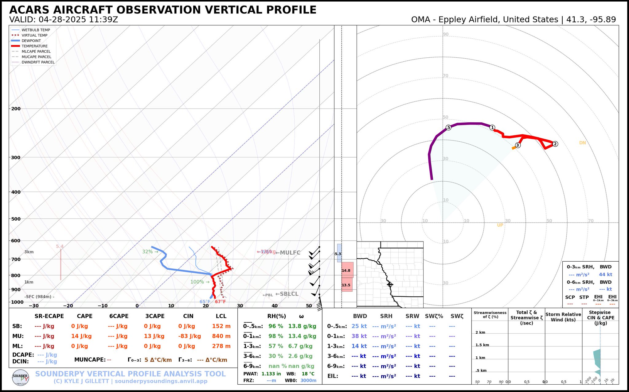
tl;dr- Conditions do seem to be lining up, but if storms just never fire, there's no risk. We're waiting on that (and wont get that answer for hours)
…..are we gonna ignore that 15%? 
(tbf that's been consistently forecasted since like Saturday, OK got a literal last minute upgrade)
To put this in an analogy (like we weather nerds love to do)
The bullet's on the table, we're unsure where the gun is.
Ok nvm
That makes more sense now


.... It might completely miss Minneapolis

The bullet was on the table, and then we tried to load it into a nerf gun, amazing last second downtrend for the northern sector.
The storms split and missed Minneapolis, segment to the south did have a few gustnadoes, but overall, system has gone more linear
refer back to here
discussion I had in a different server i'm cross posting here to save time.


The # of very upset storm chasers in MN/ IA is... notable. I would avoid the roads for a moment if you're up there (let them clear out)
Partially joking, partially not, a lot of heated sleep deprived tension among certain "teams"
5:45 PM Update
Still looking at two primary areas for severe weather this evening. More organized storms capable of tornadoes, hail & wind will push into southeast NE & southwest IA. Elevated storms capable of wind & hail will move across northeast NE.

[insert prayer to Omahadome here]
Tornado Warning continues for Augusta WI, Fall Creek WI and Foster WI until 8:15 PM CDT


Likely a quick spin up tornado occurred SE of Eau Claire.
Likely a strong tornado from that same storm segment, E of Augusta, WI.

CC is fading somewhat- might have been a real quick tree muncher.
Tornado hit Springfield, MO
Edit-
Seems like a decent (but weak) tornado, downed powerlines and trees, roofing damage reported.
(Moved a discussion as it is part of an internal investigation w/in the weather community.)
🔴 Un sismo de magnitud 7,5 en la Región de #Magallanes activó una alerta de evacuación preventiva del borde costero y zonas de playa, incluido el Territorio Antártico. Según el SHOA, no hay amenaza de tsunami para el resto del país, incluida la zona norte.
Las autoridades

Parts of costal Chile being evacuated after a M7. 5 quake at sea, possible tsunami of 1-3 meters.
🔔#Earthquake (#sismo) M7.4 occurred 226 km S of #Ushuaia (#Argentina) 30 min ago (local time 08:58:27). More info at:
📱https://t.co/QMSpuj6Z2H
🌐https://t.co/PpiLTuZZEj
🖥https://t.co/CFUq359k9B


Kentucky doesn't get tornadoes like we do in the plains, but frequent enough EF-1s that having no one in charge of the entire state of weather there is deeply concerning
Western KY certainly does, I'd note
Several of the strongest tornados in recent history are in that rough area (Central/Northern MS into Western TN into Western KY)
The CM for the Paducah, KY office retired in February, I believe the hiring freeze is what's prevented a new one from getting in.
... Also as a side note- tornado in Poland yesterday, we had a new guy show up in a storm chasing group asking if he caught something, we're of the opinion he did- he's sending it to the equivalent of the NWS there.


I knew it was someone outside the US when I saw "landspout"
probably a literal translation of a local word
Landspouts are unfortunately an American creation to describe tornadoes that dont occur under storms (or to partially explain ones that don't form in a typical way)
But given the info that was given, leaning towards this being a bog standard tornado (Probably an extremely weak tornado, but a nado. Also as a note- landspouts are not necessarily wispy nothingburgers- max recorded that I know of was a High end EF1, which is like.. decent.)
Decently strong quake in TX,

I'll admit, I didn't know that was a thing that could happen
Ok wtf that’s too strong for fracking
5.7 is significant yeah
