#Meteorology
1 messages · Page 15 of 1
WP, 32, 2025110818, , BEST, 0, 137N, 1266E, 110, 949, TY, 64, NEQ, 105, 60, 55, 95, 1005, 430, 45, 0, 0, W, 0, , 0, 0, FUNG-WONG, D,
precipitation forecast


what also terrifies me is that this reminds me of Haiyan with the way how it's still distant to my location and winds are already battering here
chasing down typhoon fung-wong today. wish me luck

Be safe and take care bro

its signal #1 here but everything is getting blown out
i cant imagine the ones with #5
😭🙏🙏🙏
🥀
stay safe chat

w icyclone
i'm barely safe, a few debris went straight to me at midnight
also, i might post a youtube video on my chase on fung-wong


poof
for epac/natl at least
wake up spac


kinda crazy its gonna intensify when its halfway inland
idk why aus storms always do that
australia? whats that
all i see is an ocean

holy
btw iona reanalysis bumped it up to c4

wait
this might get close or even hit darwin
wtf
for some reason i thought darwin was further west
major city landfall could be very yikes


looks like its gonna barely avoid darwin


wtf is that small ass eye
05S FINA 251123 1800 13.9S 128.5E SHEM 105 959
nvm they overrode

pretty far off from forecast


rain gaming
why is it stalling
mg
mf
yeah

took a halt
WTPQ50 RJTD 251200
RSMC TROPICAL CYCLONE ADVISORY
NAME TS 2527 KOTO (2527) UPGRADED FROM TD
ANALYSIS
PSTN 251200UTC 11.0N 120.2E FAIR
MOVE WNW 09KT
PRES 998HPA
MXWD 035KT
GUST 050KT
30KT 150NM
strait of malacca btw

wait thats actually a legit ts
what the shit

yeah
2nd? known storm in the strait of malacca
vamei is the only other one in recorded history afaik
yeah

💔Terrible flash flooding in Huta Nabolon, Central Tapanuli North Sumatra in Indonesia today....
yikes
recipe for disaster honestly
surprise storm that makes landfall in a completely unprepared place
jesus christ
yea thats really bad
honestly I don't remember anything hitting there since vamei
pretty sure it went extratropical before hitting sumatra
oh yeah unrelated
southern thailand is experiencing record breaking rainfall rn
like most rainfall in centuries

Yikes.
wth
i have completely forgotten that
there is indeed a wpac storm rn

@normal frost
this is Koto now
and apparently jma went 70 kts
vro istg if it hits southern central vn again
they just got some of the worst flooding in history literally a week ago

rain extremely hard and more importantly, at such a large scale, river throughput exceed even worst case prediction by 50%
yikes
WTIN31 DEMS 270942
QUADRANT WIND DISTRIBUTION IN ASSOCIATION WITH DITWAH OVER BAY OF BENGAL ON
0600 UTC OF 27-11-2025 FOR WHICH FORECAST IS PREPARED:
PRESENT DATE AND TIME: 270600
PRESENT POSITION: 6.9�N/81.9�E
POSITION ACCURATE TO 20 KM
PRESENT MOVEMENT (DDD/FF) PAST SIX HOURS: 320/08KT
PRESENT WIND DISTRIBUTION:
MAX SUSTAINED WINDS: 35 KT, GUSTS 45 KT
back to back NIO TS

uh oh
did u have
KL TC in ur bingo card for this year
because i sure didnt
also yes this is in WPAC rn
JMA has it as TD
thats not in any bingo card i know of
indeed!
fucked up month rn
vietnam/thailand/malaysia with record rainfalls
and now malaysia eating senyar
vietnam about to eat koto
gg man
its a la nina man
😔
wait actually isnt it neutral
think so?
also interestingly gfs sees senyar merging into koto later on
truly a typhoon season of all time

yeah

💀
brr

very good
2nd costliest NIO storm as well
06P

still in FMS aor tho
😔
theyre tracking it but don't think it'll be nameable
TDist to them i think
theres an ss in spac apparently
huh
07S SEVEN 251212 0000 8.1S 98.0E SHEM 35 1005
yeah

will it stop bakung and start cookung

it did for a bit
kinda forgot this storm existed didnt realize it popped an eye LOL
08P EIGHT 251214 1800 13.4S 169.4E SHEM 40 997
now dead

i go into hibernation until a major basin wakes up again
its gonna be nina next year too 😔

yeahhh
but hey off season is fun too
only when something funny happens

update

lol wtf it actually DIED


also thats former 03U
so yeah it didnt Die
huh


yeah


ZAMN
???

funny!!!


swag
hayley reached major (BoM)
hayley died a while ago
grant is struggling
anyway theres an AOI in aus
probably gonna be the first storm of the year
the first storm of 2026 has formed
say hello to tropical cyclone iggy

though...if you go by jtwc they had this as a TS on 18z
so you could also say it was the last storm of the year


true

dry aird
iggy is non-tc now for bom
unforch
dont think they have it as a tc for more than half a day
not the season unfortunately
well tbf
aus is starting extremely strong
3 majors + 2 named TS (of which one became a near c5 in swio)
🗣️🗣️

interesting

its still on its last legs btw

kinda just there

thats certainly a shrimp


jenna seems to have peaked
c2/mid aus c3

#Jenna has likely peaked today at 12z as a Category 2 cyclone, with sustained winds of 90 kt (105 mph/170 km/h) supported by T 5.0 at 6z and 12z. Although the storm exhibits strong poleward outflow, recent satellite imagery indicates that increasing wind shear is restricting its outflow to the north. Vortical hot towers are struggling to wrap, and the eye has become less well-defined. Increasing mid-level dry air will contribute to Jenna rapidly weakening and decoupling throughout the next 24 hours.

good run

t5.0 was good


well...
also i just realized they were initially forecasting a direct hit to a city of 200k lmao

and there it is


btw we have a NIO DD
got named koji
nio system are we back
🥀
honestly idk ive been checking on it less often due to other stuff as well
tho it still depends on whats happening ofc


Maximum sustained winds (averaged over 10 minutes) at sea: 205 km/h.
Maximum gusts at sea: 285 km/h.
Estimated central pressure: 937 hPa.
Position on January 12 at 4:00 PM local time: 16.8° South / 77.9° East.```jtwc has c4

btw wpac invest


hoh


WTPQ50 RJTD 150600
RSMC TROPICAL CYCLONE ADVISORY
NAME TS 2601 NOKAEN (2601) UPGRADED FROM TD
ANALYSIS
PSTN 150600UTC 09.9N 128.9E FAIR
MOVE NW 07KT
PRES 1000HPA
MXWD 035KT
GUST 050KT
30KT 180NM NORTH 120NM SOUTH
first January named ts in a while
wao an actual jan storm

ikr


ig every other condition is so good that it just pretends the shear doesnt exist
thats my goat
average jet interaction things


again???

dudzai doing their 3847th reintensification
kekw

oh yeah
nokaen is still alive
@normal frost
just in case you forgot abt it

its the thing on top


nokaen finally died
dudzai is dying for the final time

anyway we have ewetse
honestly theres a lot of potential storms rn in shem so lemme just send a summary from someone else
the satelite scan on jtwc for this is pretty funny rn
theres quite literally nothing there
yepppp

that was indeed a storm
oh yeah just in case it wasnt known
eweste already died
also another SPAC TS is dying without being named!
17S SEVENTEEN 260123 0000 13.5S 119.8E SHEM 35 995
when the agencies are sleeping
tbf bom forecasts one of them to form
and another one at medium chance

yeah

dont be fooled this isnt an ocean
thats western australia 💀
whatevers left of luana
also this was hilarious
Despite having moved inland, #Luana is looking better than ever over the Australian Outback, with an eye developing on both visible and infrared imagery, as well as traces of one on microwave data. Upper-level troughing to the southwest is feeding a robust poleward outflow jet.
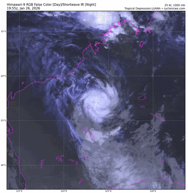

further proof that australia doesnt exist

because it doesnt exist
fantasyland


love it when agencies dont name literal TS
peaked 55kts apparently
but probably has c1 support i wont be surprised
unnamed btw!
so that died
anyway
PHENOMENON: MODERATE TROPICAL STORM 9 (FYTIA) 996 HPA
POSITION: WITHIN 30 NM RADIUS OF POINT 15.6 S / 42.4 E
(FIFTEEN    DECIMAL SIX   DEGREES SOUTH AND
FORTY TWO    DECIMAL FOUR   DEGREES EAST) AT 0000 UTC
MOVEMENT: EAST-SOUTH-EAST 3 KT


???????????
itc is on the table
accd to mfr
also another spac tc formed
that very likely Wont Get Named
:D

it got dry aird gg
aw man

wild for being channel storm
yeah

spinny funne
thats 18u btw
same 18u as the one here


havent seen south ph storm in a hot minute
WTPQ50 RJTD 041200
RSMC TROPICAL CYCLONE ADVISORY
NAME TS 2602 PENHA (2602) UPGRADED FROM TD
ANALYSIS
PSTN 041200UTC 09.1N 131.9E FAIR
MOVE W 06KT
PRES 1000HPA
MXWD 035KT
GUST 050KT
30KT 180NM NORTH 120NM SOUTH
jan and feb storms btw
kinda wild
last time was 2019 apparently
live climate change reaction


pog
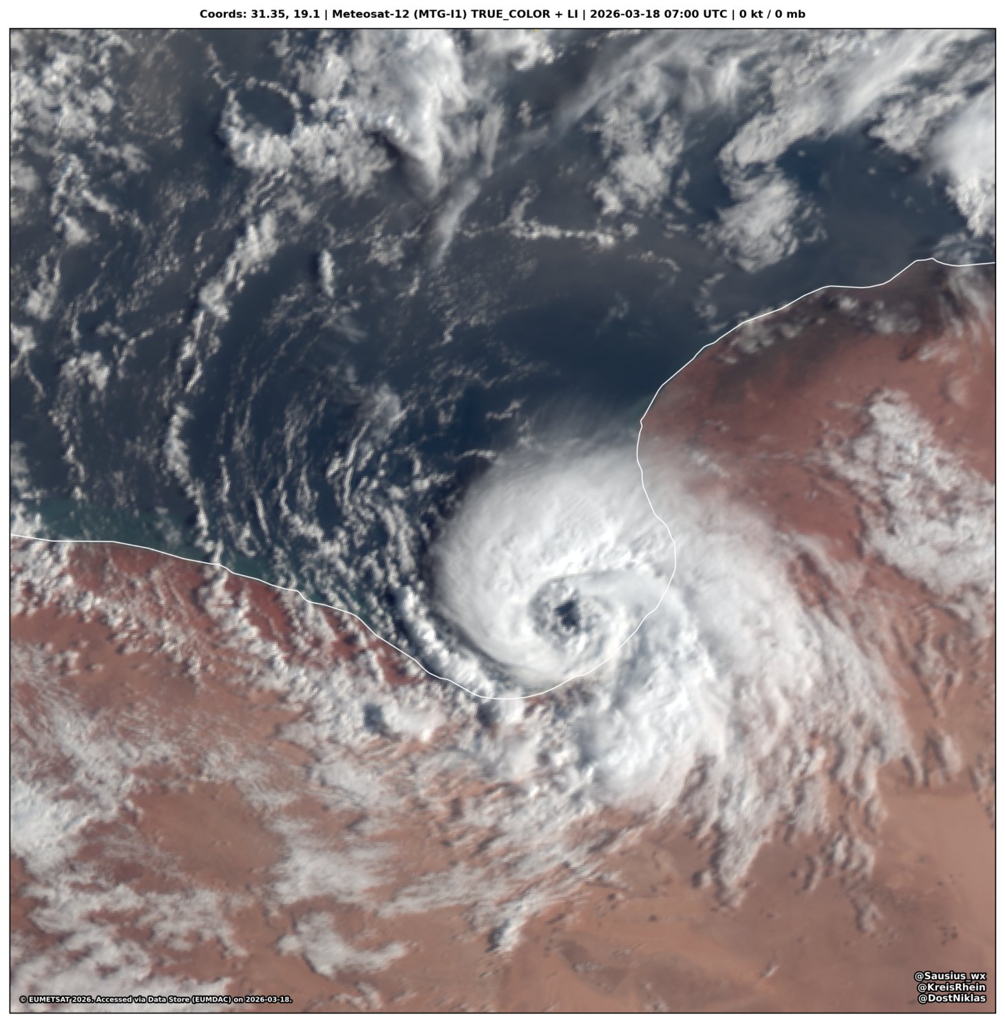
this is the most aus track ever
ikr

road trip
why does aus always do this lmfao
because australia is a figment of your imagination

I am tired of you fools thinking that Australia is a real place. It isn't. Understand? Australia does not exist.
OTHER AUSTRALIA VIDEOS:
Full playlist: https://www.youtube.com/playlist?list=PLx_Pte0WdDrRiFN9GgDXNXAq9oT9F8PNV
Australia isn't real: http://bit.ly/2sIm2uj
I Went To Australia: http://bit.ly/2sIm8SH
Interviewing Australians: https:/...
me rn
LMAO
oh yeah it got named already
way ahead of schedule
(apparently)
(still havent seen it on bom website)

but this was 3 hours ago

poge
ts mitchell
cuz i forgor to specify name
this thing has technically been around since jan 22 btw


wtf its huge

now that thing is FAT
thicc boi
also penha is dead
apparently damage was really bad

Massive flooding caused by Tropical Storm Penha (BasyangPH) in Barangay Mahayahay, Iligan City, Philippines 🇵🇭
jesus


this one finally got named
earlier forecasts had an ITC
meanwhile mitchell is struggling a bit as it approaches landfall
seems to have peaked earlier

anyway newly named gezani
it left the yummy air zone so yea a bit
so many madagascar storms this year

yeah
welp it over performed i think
ono

erm

Gezani has undergone rapid intensification throughout the past 24 hours. The storm has likely peaked as a powerful Category 4 major cyclone, with winds around 120-125 kt (140-145 mph). 15z is also unofficially DT 6.5. Gezani is about to make landfall, and residents in Toamasina Province should remain in shelter due to dangerous winds, storm surge, flooding, and landslides. Stay safe, everyone!

yikes

unfortunately
it made direct landfall on the 2nd biggest city in madagascar
toasmania
did so right at peak too
thats...bad

🥲


?


this storm wants to be freddy so bad

not today gezani

22S TWENTYTWO 260220 0000 14.5S 76.0E SHEM 35 1001
yeah jtwc forecasts 100kt
PHENOMENON: MODERATE TROPICAL STORM 11 (HORACIO) 996 HPA
named poge
yea well not surprising
it is kinda prime india season rn


dude WHAT

back on schedule


WAIT WHAT THE FUCK
[OVERRIDE]
22S HORACIO 260223 1800 20.7S 65.1E SHEM 140 920
HUH
what does that even mean
i dont think galeforce winds pleases the eyes
oh wait i just woke up
i dont think hurricanes eat cereal
in fact dry cereal may dry it up
LMAO
nothing happening rn outside of horacio dying


hoeh


nz metservice declared urmil as EX
sleepge

merge wen

woo hoo more slop
WTPQ50 RJTD 101800
RSMC TROPICAL CYCLONE ADVISORY
NAME TS 2603 NURI (2603) UPGRADED FROM TD
ANALYSIS
PSTN 101800UTC 11.7N 138.1E FAIR
MOVE ALMOST STATIONARY
PRES 1000HPA
MXWD 035KT
GUST 050KT
wpac retirements
WIPHA, CO-MAY, MATMO, MITAG, RAGASA, BUALOI, KALMAEGI, and FUNG-WONG
its the typhoon jumpscare
hit the ph on the west side

Hong Kong's contribution to the international list of typhoon names is set to become more appetising, after a United Nations panel approved "Dim-Sum" as a replacement for the name "Man-yi."
🔥
96P (aus) and 97P (spac)


Earlier today, the storm known variously as Samuel, Jolina or Quibilah made landfall along the Lybian coast near New Brega (البريقة الجديدة) as a 'medicane', a type of subtropical storm. 1 minute sustained winds were likely on the order of about 85 km/h (52 mph)


also damn awaken left 😔


sinlaku.