#Meteorology
1 messages · Page 9 of 1


huh
that form is super good though
such a radarcane LOL
that's the best looking one on radar in a long while
yeah its fuckeddd
radar on par with a good chunk of c5s
oh yeah they lowballed 12z @normal frost
105 or 110 kts i forgor anyway irrelevant
18z was 105 tho
and yeah its joever storm is going ett

nvm they overrode a shit ton
06S ANGGREK 240130 0600 29.1S 72.8E SHEM 100 957
06S ANGGREK 240130 0000 28.0S 71.7E SHEM 105 952
06S ANGGREK 240129 1800 26.4S 70.9E SHEM 110 950
06S ANGGREK 240129 1200 25.1S 70.8E SHEM 120 960
06S ANGGREK 240129 0600 23.8S 71.1E SHEM 115 948
06S ANGGREK 240129 0000 22.7S 71.9E SHEM 115 954
i gotta say tho
120 960...
?
@normal frost

wanna talk about how a storm just survived being in australia?
and i mean in the literal sense because
07P KIRRILY 240201 1800 17.3S 139.5E SHEM 40 992
WTF


that looks wild
BoM be like "oh it hit land i guess its dead"


wtf


@normal frost ?????????
last minute named
wasnt expected to get named either cuz not 3/4 gales
checked earlier and gale radius went down too so this is a very pleasant surprise

also djoungou named
yes thats actually its name
wtf

i really didnt expect this to be named tho after it missed its chances yesterday
bom only gave it a moderate after all even tho it had gales

if i had to guess tho
this ascat prolly sealed the deal
pretty decent swath of 35s
also damn asynoptic time naming
cuz it got named 3 hours ago

@normal frost anyway this storm will probably cook soon

and this exists but uh
🥱
what a shrimp
could be the next big storm ngl
and then maybe lincoln after that
models want it to regenerate in the indian ocean later on


WTF FEBRUARY WEJJ

@normal frost sheared wejj
jtwc interestingly went c4
while mfr went 5 kts shy of intense tc
aw
@normal frost
never mind

this shit stepped on the fucking gas panel
imd and jtwc have DT6.5 fixes
for 6z
problem is
its out of time
no idea if it'll make it to 12z while maintaining peak

but wow
absolute fucking specimen
fr

@normal frost i wonder if this is a missed c5
tho probs not
that said
mfr did go 115 kts 10-min
just 5kts off from vitc

I mean it's a strong c4 at the very least

🫡


slopfest

@normal frost also this guy actually made it out of australia hoyl

ex-Lincoln in case u forgot
i mean
its pretty common atp
the question is how many actually make it out and reform
too bad its alr named tho
wouldve been nice to see another named AUS storm
the world if aus is actually active

radarcane 

@normal frost finally something happened
took almost one fucking month
don't like how snore everything has been recently zzz
bet this year is gonna be ultra sleeper considering we'll prolly be in la nina again
Hopefully its a sleeper here in ph 🙂
I dont want a super typhoon just ripping my a open
likely wont be
even tho la nina means less storms
usually it also means that more storms will track towards the philippines (and onwards to vietnam)
whereas el nino has more storms but also more of them recurving towards japan or just below it
💀
at least climatology wise
a good example of that would be 2020 with its train of storms hitting the PH
bro thinks hes freddy

what the fuck
shem moment
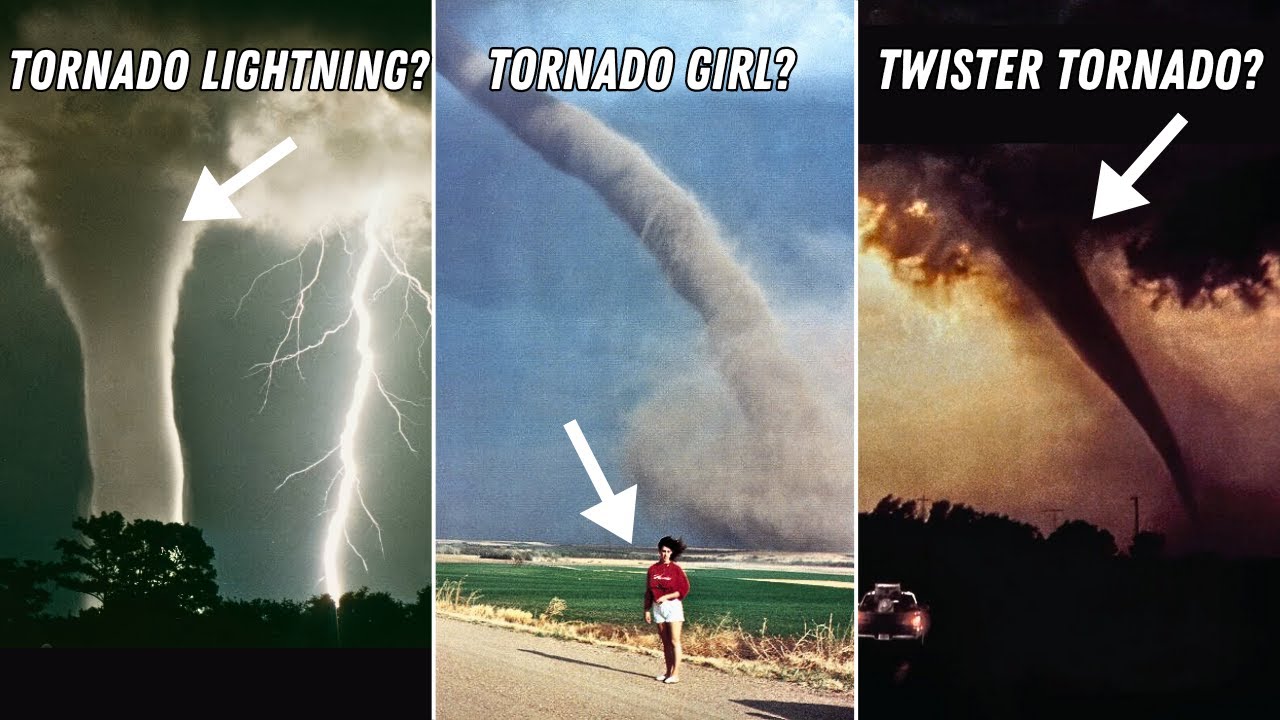
Today we're checking out some classic tornado pics. Thanks so much for watching and subscribe for more tornado and science content!
Content:
0:00 Intro
1:05 Fred's Lightning
3:26 Twister Movie Tornado
6:35 Dead Man Walking Tornado Photo
7:51 Tornado Girl
9:20 Palm Sunday Double Tornado
12:15 Swirling Barn Tornado
13:11 Scary Car Tornado
Link...
goat

☠️


what is this carpentaria magic
tfw
slop 18S was forecasted to become a strong storm
and that never materialized
meanwhile here's 19P(or is it S?) coming out of nowhere and now overperforming lmfao
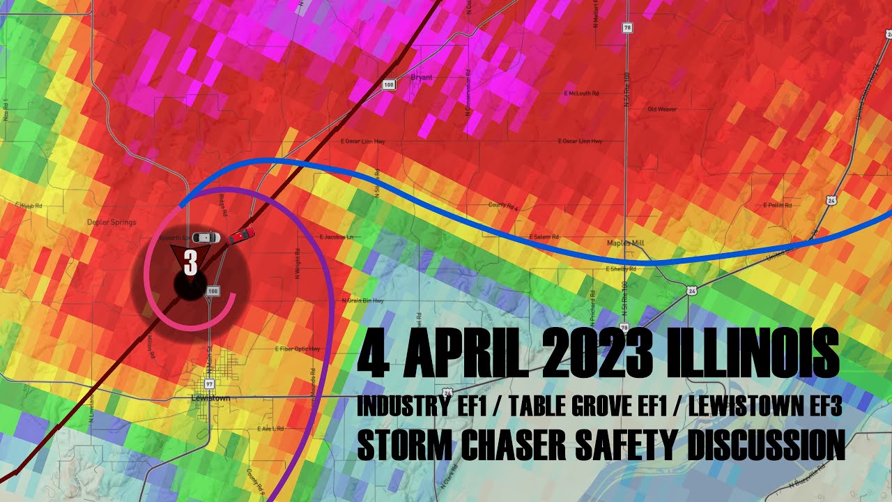
A deep dive case study on the storm chaser tornado impact accidents that occurred near Lewistown, Illinois on April 4, 2023.
goat uploaded

what a shrimp
this upper part though is kinda...

could be?
wonder if it'll still be able to get a name atp
it'll either peak as a high end c3 aus or low end c4 aus
cuz it has a day left

or a bit more than a day
inb4 stall
surely not
ill check mid level winds n shit
gn
o/
upper is all over the place lmfao
lower basically 0 wind
although divergence suggest it'll go normally
really low shear so it does have that going for it
mid level shear might slow down the intensification but wont hinder much it seems
yea i think it will just do what the forecast says
nothing of note

fair enough

oh dear
19P MEGAN 240317 0600 15.0S 137.0E SHEM 85 962
yeah
major on the cards???


zamn

woah

i actually cant think of one
LMAO
is it 2019
random guess
nvm its def not 2019
what the fuck i dont have typhoons hitting japan memorized 😭

took them SO long
2 weeks
2 fucking weeks
megan literally formed and died before this got named 😭

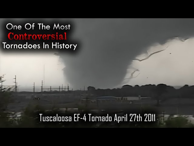
Tuscaloosa EF-4 Tornado Documentary
During the late afternoon and early evening of April 27th 2011, Tuscaloosa, Alabama would become the focal point for one of the deadliest tornadoes to have ever hit the United States.
A high end EF4 multiple vortex tornado would spin it's way through Tuscaloosa and Birmingham causing untold amounts of damage....
this tornado still fascinates me
idk if I should call the people dumb or appreciate the fact that it's because of them we have so much footage of it


MOM ITS DOING THE THING
wao yea thats p compact


@normal frost wow.
to think that hurricane equivalent wasnt even forecasted before
holy that looks so good
TC ADVISORY
DTG:                 20240322/0000Z
TCAC:                DARWIN
TC:                  NEVILLE
ADVISORY NR:         2024/8
OBS PSN:             22/0000Z S1748 E10236
CB:                  WI 80NM OF TC CENTRE TOP FL600
MOV:                 W 10KT
INTST CHANGE:        INTSF
C:                   958HPA
MAX WIND:            95KT
FCST PSN +6HR:       22/0600 S1754 E10112
FCST MAX WIND +6HR:  100KT
FCST PSN +12HR:      22/1200 S1806 E09948
FCST MAX WIND +12HR: 100KT
FCST PSN +18HR:      22/1800 S1824 E09812
FCST MAX WIND +18HR: 95KT
FCST PSN +24HR:      23/0000 S1848 E09636
FCST MAX WIND +24HR: 95KT
RMK:                 NIL
NXT MSG: 20240322/0700Z```@normal frost woah
bom forecasts 100kts 10min peak
tho
jtwc is already at 115 kts 1-min

damn it does not wanna give up

@normal frost nvm its joever

or starting to be joever
i wonder if it'll make it to swio as a hurricane-equivalent


@normal frost
With the sinking cell heading out, 95S has an improving environment with potential to become the next strong storm under low shear although upwelling could become an issue with it's slow movement.
After that a jet interaction could cause RI as well.

could be big
what a spot


wait HUH
forecast ITC...
i didnt even get pinged for this discord wtf
in 24 hours

gonna suck for reunion/maurice

this looks to be a rain boyo
this was 3 hours ago
or actually
7 hours ago
wait is it 7 or 5 @normal frost

like
Dude
this shit broke the gas pedal
oh naw
this fucker i swear
moment.
AWA


yea
i wonder what will happen first
a landfall
or it becoming a major
yeahhh
wait what
unexpectedly
ok that was fast
yeah
wasnt expected to make a landfall at all
major peak got thrown out the window
i mean
it wouldve been better if it followed its original track forecast
yknow
literally Not making landfall
anyway
peak for MFR was 80kts 10-min
so about 90 kts
still wouldve been affected nonetheless
so prob cant be avoided there

sus
🤨
A deep dive case study on the storm chaser tornado impact accidents that occurred near Lewistown, Illinois on April 4, 2023.
having synchronized footage is so interesting
because I can like
immerse myself
and think "what will I do in this situation"
damn
TS olga

woah


@normal frost 75 knots.
bom isn't doing any better either with 70 knots 10-min.


the wejj is comin

yea its kinda lopsided

A. TROPICAL CYCLONE 21S (OLGA)

B. 07/0830Z

C. 15.13S

D. 119.25E

E. ONE/GK2A

F. T5.5/5.5/D2.0/24HRS  STT: S0.0/03HRS

G. IR/EIR/VIS/MSI

H. REMARKS: 07A/PBO IRREG EYE/ANMTN. OW EYE SURROUNDED BY W YIELDS
AN E# OF 6.0. ADDED 0.5 EYE ADJUSTMENT FOR W, TO YIELD A DT OF 6.5.
MET YIELDS 5.0. PT YIELDS 5.5. DBO PT.

I. ADDITIONAL POSITIONS: NONE


FLEWALLEN```@normal frost how do you turn a DT6.5 fix into a T5.5?????

also Holy Mother Of God

@normal frost
2nd coming of Herman jfc
THE WEJJ

yeah
tho tbf an official c4-equivalent is pretty wejj enough

shear 
man


thats one hell of a forecast
yeah thats a graph of all time
or forecast rather
funny track pls

decent ig


zamn
nvm it collapsed while i was asleep bruh
lol
well
i guess it overperformed somewhat
damn dry air,,,
welp that's the shem season
outside of the AUS it was pretty Darn Mid
sleeping waiting for the main seasons
aus season is pretty mid yeah
which is prob for the better
no i mean the other 2 shem were mid
aus did pretty well
i mean we had jasper, anggrek, neville, olga
- megan and kirrily
6 c1+ out of 8 storms is a neat ratio
meanwhile spac's strongest storm was literally outside seasonal bounds
and outside of anggrek and djoungou swio was pretty unremarkable

Chasing a 42 mile long tracking tornado in Iowa. This tornado impacted Houghton Iowa, New London Iowa and rural areas southwest the Quad Cities vicinity. With peak wind speeds estimated at 130 mph this tornado earned an EF2 rating. NWS calculated a 600 yard width and 42 mile length.
More info soon...
SUPPORT THIS CHANNEL
https://www.patreon.c...
my goat uploaded

last flop*
true...
no 😭😭😭
😇
wpac is so joever

tanzania though
tanzania hasnt seen a landfall right?
jobo was the closest i think
woie
hard pass
LOL

wtf jumpscare
i forgor this storm existed

bro has a Core


at least it will weaken before landfall
though this is still really worrying still
because apparently this is quite a lot of rainfall
yeah
in a region that doesnt really see this kinda thing much
im not particularly liking how this is turning out ngl
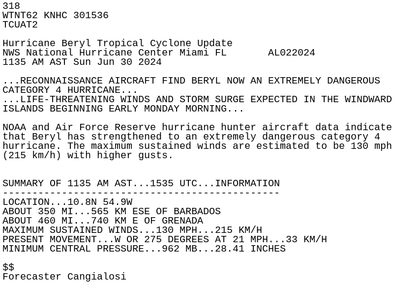
models had it supposedly weakening by now
jobo repeat moment

yea the tanzania storm killer is here
it really shouldnt exist
thats literally why storms dont hit tanzania
why does it exist
i have no idea
also did u see the gfs thing
i think it was like yesterdays model
indonesia system 
oh yeah
16U lmao

dont u fkin dare

@normal frost mfr still wants a sharp turn
yeah rofl

@normal frost damn.
now lets see if 16U does anything or not
oh yea here jtwc cone

death

LOL
can we not have double historical storms in may
that cursed indo storm lmfao
honestly
the scarier fact is that
its consistent
lmfao

precursor
thats what i told u here
like
WHY IS IT STILL THERE
yeah,,,,
surely we dont actually get an indonesia cyclone right

society when indo gets hit by a cyclone before the ph gets a typhoon
surely rightttt
I will never get why hurricanes are categorized by their windspeeds but tornadoes by their damage
like I'm trying to look at it differently but I simply don't see how making the main tornado measuring system be by damage is better than making it by windspeed
and speaking of categorization
hurricane categorization should take the amount of rainfall into account too if the point is to make the public aware of the danger
massive example: sandy
literally majority of the damage is from the rainfall not the winds itself
true honestly
its weird
sshws is a pretty bad scale to base damages off when u think abt it
cuz so many factors can affect how damaging a storm can be
storm surge, its speed of movement, whether its in an ewrc or not, etc etc
thats why weather graphics have to fill in the gap for those parts
like showing how big a surge can be on a given area
¯_(ツ)_/¯

oh?

the most cursed part about the EF scale is that there was a study comparing F and EF scales
and EF scale underrates tornadoes an average or almost 1.5 categories
not flawed btw !!!
thankfully NWS is working on a new system now

mega quaking rn


oh wtf
Monstrous tornado after bairly hitting a house but gets rated EF1 for minimal damage (I always think of El Rino 2013 in the US)
yea 2013 el reno had one of the highest recorded wind speeds but only recieved EF3 rating because it barely missed a house
I've studied enough to stop questioning "why x tornado isn't EF5"
but I still think rating tornadoes by damage is stupid
if your main point of having the rating is to warn the public of the danger then why is your rating system based around needing the tornado to destroy something first
Because tornados destroying something means it is likely on the path to destroy more things
Both need to be taken account to rate a tornado
you're failing to consider the fact that you need experts to go there to assess the damage first THEN the rating comes out
and no one is gonna walk in there until it leaves the area already
by the time people get there it's likely to have traveled into another town
There is no live rating based off wind speed?
effectively currently no
there's only tornado watches/warnings/emergencies
but even that's kind of flawed because people won't get a feel of how dangerous it is
there's more people going out on the streets to take pictures/videos than actually taking shelter
yea so I just found out the only reason mayfield isn't EF5 is because the DI claims the "swept off it's foundation" the house doesn't have supporting bolts so it doesn't count as a "well constructed home"
scam


what the fuck why is it going north thats not supposed to happen
whats with swio storms this year and going north
hey remember when this was supposed to wejj out to the south

what the fuck thats so close to equator

WHY


looks to have peaked @normal frost
but damn 60 kts 10-min is still impressive
double c1 equivalent storms in may
yea its really impressive
25S TWENTYFIVE 240519 1800 2.3S 75.2E SHEM 35 1002
@normal frost
likely gonna stay unnamed though
but probably an upgrade in post analysis
😔
UHHHHH
@normal frost @normal frost @normal frost @normal frost
WHAT

??????????????

EXCUSE ME
YOU'RE SUPPOSED TO BE DEAD BY NOW????
yeah just normal stuff you see in the FUCKING OFF SEASON AT 6 DEGREES SOUTH


WAIT
NVM THATS OUTDATED
Informations à 09UTC
Position : 4.8°S / 42.2°E
Déplacement : Nord-Ouest, 5 kt
Vent maxi moyenné sur 10min : 65 kt
Pression centrale : 983 hPa
Pour plus d'informations, se référer aux bulletins WTIO21 et WTIO31 à venir à 12UTC et suivants.```WHAT

AND ITS FUCKING 3S WHAT IS HAPPENING
yeah.
kenya landfall.
afaik no
bro tanzania landfall was already extraordinarily rare
this is the first
now a kenya one???????
💀💀💀💀💀

@normal frost dear god have mercy
trying to get dual vhts.
oh yeah
mfr now officially has 65 kts 10-min
jtwc...has 60 kts 1 min 💀
jtwc...

saved

o


@normal frost no shot jma thinks this is 35 kts
and are forecasting like
55 kts peak
for reference jtwc has that intensity right now and is forecasting 100kts
what the fuck that looks at least 50kt


yikes
RSMC TROPICAL CYCLONE ADVISORY
NAME  TS 2401 EWINIAR (2401)
ANALYSIS
PSTN  261500UTC 15.2N 122.4E FAIR
MOVE  NE 08KT
PRES  1000HPA
MXWD  040KT
GUST  060KT
30KT 60NM```@normal frost speechless rn
wait wtf
smth interesting happened
cyclone megan got upgraded to aus c4 by BoM in its TCR
woa

@normal frost landfalling
cyclone remal
thank god it didnt have an extra day lol it just started wrapping earlier
likely wouldve done the Unfunny if it had time

imd has 60 kts
jtwc 55
thankfully its making landfall only that strength
yeah


😔
probably peaked as a major
tho gotta say seeing jma have this peak as a 65 kt typhoon is hilarious
think it sustained dt5.5 for a long time
maybe even reached 6.0?

again????
yknow whats the funny part
thats 25S
from like
2 weeks ago
Happy start of summer from Vorkuta 

nice summer bro
damn...
Evil summer
there is
Nothing Happening
!!!!!!!!!!!
oh wait
tropical storm alberto is a thing
guess thats something
sleeper
wake me up when wpac wakes up
it is Sleeping

it has B E G U N

idont cARE
let it cook
AND WHY IS IT STARTING TO DO THE THING
chat it is cooking
natl literally has to pick up the slack the pacific is DEAD
epac literally on the latest start in recorded history (still hasnt formed a Damn Thing)
wpac is
wpac.
@normal frost

wanna talk about how
there's a major forecast
IN JUNE
?????????????
ill take it

wait nah the fuckk is it doing
tracking hurricane beryl?
yup
oh

poof

@normal frost hey what do u think of a major in june
3 more advisories left within june so i wonder if it'll make it
yea
i hope it veers north though
whats the strongest june storm anyway
those islands wont have a good time
hopefully but also pretty unlikely
Recon found #Beryl very near major hurricane status, with winds ~95kt and pressures in the high 960s. We'll likely see it intensify to 100kt while the plane is in the storm. Nice temperature spike!

@normal frost BRO
ITS JUNEEEE
WTF
good chance it gets first june major since alma
which was IN 1966
...BERYL IS NOW A VERY DANGEROUS CATEGORY 3 HURRICANE...
...LIFE-THREATENING WINDS AND STORM SURGE EXPECTED IN THE
WINDWARD ISLANDS BEGINNING EARLY MONDAY...
SUMMARY OF 800 AM AST...1200 UTC...INFORMATION
LOCATION...10.6N 53.9W
ABOUT 420 MI...675 KM ESE OF BARBADOS
MAXIMUM SUSTAINED WINDS...100 MPH...155 KM/H
PRESENT MOVEMENT...W OR 280 DEGREES AT 21 MPH...33 KM/H
MINIMUM CENTRAL PRESSURE...968 MB...28.58 INCHES
@normal frost what did they mean by this
category 3
100 mph
:trolley:
ok but jesus christ
it actually happened.
recon found support for 100 kt
what do they mean by this
...BERYL IS NOW A VERY DANGEROUS CATEGORY 3 HURRICANE...
...LIFE-THREATENING WINDS AND STORM SURGE EXPECTED IN THE
WINDWARD ISLANDS BEGINNING EARLY MONDAY...
SUMMARY OF 800 AM AST...1200 UTC...INFORMATION
LOCATION...10.6N 53.9W
ABOUT 420 MI...675 KM ESE OF BARBADOS
MAXIMUM SUSTAINED WINDS...115 MPH...185 KM/H
PRESENT MOVEMENT...W OR 280 DEGREES AT 21 MPH...33 KM/H
MINIMUM CENTRAL PRESSURE...968 MB...28.58 INCHES
fixed now
@normal frost so
wanna talk about how
this is by far and large the strongest june mdr storm?
It cannot be underscored how historic of a situation this is. To have a major hurricane east of the Lesser Antilles in June is a feat no season, not even 1933 or 2005, accomplished.
We will probably not see another storm like #Beryl in our lifetimes.

Hurricane #BERYL has become a Category 3 major hurricane, the first major hurricane in the Atlantic Basin since Hurricane ALMA in 1966.
Beryl is also the 3rd-earliest forming major hurricane in Atlantic history, as well as the only known major hurricane to ever form over the

@normal frost hey so
what if i told you there's a legitimate possibility that this thing becomes the first natl c4 in june
guess what
recon found 115 kts sfmrs.

also i believe BT has 105 kts? @normal frost
02L BERYL 240630 1200 10.6N 54.0W ATL 105 968
ok yea it does
8 hours to get 10 knots
damn they maintained 105 for advisory
@normal frost @normal frost @normal frost @normal frost @normal frost
my eyes are wide open rn
126kt FL 132kt SFMR
This is insane. 132 kt flight level and 126 kt SFMR winds in Beryl

im actually Done
lasted 1 hour
💀
115kts/962mb is wild tho
hey ill take it

prayge it dies like
right now
also off topic alma being a major on june 8 is wild as fuck
yea that is fucked up


🙏
india also has a world cup winning team stranded there too
big yikes
and if im not mistaken the area its targeting hasnt really felt a hurricane in 2 decades? dont have source for this tho
yikes

@normal frost of course its gonna start an ewrc now out of all times
why is everything literally going in the worst route possible
Historically speaking, there's a very noticeable tendency for the rapid intensification (RI) phases of Atlantic TCs to terminate w/ intensities ~110-115 knots, which is how strong Hurricane #Beryl has been for much of today.
This tendency for Atlantic RI to terminate for

quite interesting
are you fucking srs