#Meteorology
1 messages · Page 6 of 1
@normal frost
[Override]
04W TALIM 230718 0000 21.9N 108.8E WPAC 60 979
04W TALIM 230717 1800 21.4N 109.7E WPAC 70 973
04W TALIM 230717 1200 21.2N 110.9E WPAC 80 973
04W TALIM 230717 0600 20.8N 112.2E WPAC 85 971
holy shit
c2
its official
ish
well jma doesnt have typhoon but who cares about them
yoooo
@normal frost HOLY SHIT
its a fkin small world
i found a former f13 mod
IN MY LOCAL MAIMAI BRANCH
what
LMFAOOOOOO
LMAO
you cant make this up
DUDE
IT WAS THE GUY WHO DANCED WHILE BEING HIT BY TYPHOON GONI TOO
WHAT ARE THE FUCKING ODDS

shrimpers


@normal frost nhc wake up
this aint 45 kt
in other news
04E formed
not expected to do much
doksuri has formed


BRO ENTERED 26C WATERS AND DECIDED TO COOK 🔥🔥🔥🔥🔥
its been in sub 26c waters its entire life rofl
🔥 🔥 🔥 🔥
AL, 05, 2023072212, , BEST, 0, 385N, 499W, 50, 998, TS, 50, NEQ, 20, 0, 0, 20, 1016, 150, 20, 0, 0, L, 0, , 0, 0, DON, D, 0, , 0, 0, 0, 0, genesis-num, 013,
50 knots????????????
LMAO

so truege


bro out here becoming a hurricane AT 40N
BENGMEGMA BUFF 🔥 🔥 🔥 🔥 🔥
INTENSIFYING THROUGH SHEER HATRED 🔥🔥🔥🔥🔥
FUCK THE HATERS WE WINDING 🔥 🔥 🔥 HIS RAGE FUELS THE STORM 🔥 🔥 🔥
@normal frost
AL, 05, 2023072218, , BEST, 0, 395N, 501W, 60, 991, TS, 50, NEQ, 30, 20, 0, 20, 1016, 150, 20, 0, 0, L, 0, , 0, 0, DON, D, 0, , 0, 0, 0, 0, genesis-num, 013,
i have no words.

60 knots
im going to bed good night

@normal frost what
(also its a hurricane now)

what it looked like when upgraded
Bro just speedran an EWRC for literally no reason #Don
💖 15
what is bro doing
anyways
moving on

doksuri 🤨
🤤
😇


rn its either us or taiwan 💀
gdi
or if it somehow misses both we end up with a china landfall 💀💀💀
👻

NOOOOOOOOOOOOOOOOOO
what
what

Roblox
Check out Twisted [BETA]. It’s one of the millions of unique, user-generated 3D experiences created on Roblox. This game will NOT run well on low end devices!
Twisted is a storm chasing game by Willzuh and Siryzm.
Throughout the rolling hills and prairies of the fictional state of Keysota, scientists and thrill seekers alike set out on the...
kinda related?
game is getting an overhaul in about 2 hours 15 mins
this is the most realistic stormchasing game that I know atm
give it a try if yall interested


fuck
oh fuck

05W DOKSURI 230724 1200 16.5N 125.8E WPAC 120 935
ewrc possibility is increasing apparently
@normal frost
oof
oh dear

that looks wild already
likely skimming luzon before heading to taiwan
oh damn
tracking...

my third hour tracking the storm
likely going to batanes in any hour

stay safe yall


rip japan
also shanghai
thats a sub-950mb storm crossing the Yangtze river delta 💀💀💀💀💀💀
💀💀💀💀
it will likely turn to be a category 2 by tomorrow

rn im not
🙏
😂😂😂😂😂
back in late 2000s part our house's roof got torn off
😂
finally the sun shines
🙏


china mfs looking at this run rn:
ok but like
triple fujiwhara.
A buoy located at 22.5989N 118.9994E (right on the inner eyewall) recorded 935.8 mb and a 2-min sustained winds of 44.4 m/s (86 kts) at 1640Z. #Typhoon #Doksuri

@normal frost
yeah
im surprised its still holding itself together


gm jma
doksuri seems to have made landfall in fujian
@normal frost
looks like jtwc agrees with jma
thats...not really a good sign
shanghai 💀
oh boy

@normal frost holy shit
this run is golden
that storm that forms near taiwan only to recurve to shanghai LOL
yeaaa
WHAT
bro avoided mainland japan and s. korea 🗿
"sike fuck you china"


yeaaaa
https://media.discordapp.net/attachments/716216151440490538/1135415553813651467/himawari_VIS-B03.gif

wow.
oh fuck thats quick
yeah
jma also has 85kts koba-10m
welp bois
wpac on crack

kinda wild how we're 6/5/3 for wpac rn
Severe flooding in Beijing after heavy rainfall; at least 2 people confirmed dead, others missing
💖 164
@normal frost oh my fucking god
oh fuck
@normal frost the fk
...DORA QUICKLY INTENSIFYING...
SUMMARY OF 900 AM MDT...1500 UTC...INFORMATION
LOCATION...16.1N 108.6W
ABOUT 345 MI...560 KM SW OF MANZANILLO MEXICO
MAXIMUM SUSTAINED WINDS...60 MPH...95 KM/H
PRESENT MOVEMENT...W OR 280 DEGREES AT 16 MPH...26 KM/H
MINIMUM CENTRAL PRESSURE...1000 MB...29.53 INCHES

idk man
2023 being wack

its stalling btw
apparently winds are weaker than expected?
due to dry air intrusions and the like
I mean expected
I love getting trolled by jet stream
when jtwc went mid-level c4
apparently both sar and smap found winds at high end c1 level 💀
truly a Mood

@normal frost here is your 80 kt dora

what this thing doing
🤨
the funny?
that looks 60 not 80 lol
yea lmao
wait
how do we look for mw imagery again
one of the websites idk

beautiful
EP, 05, 2023080212, , BEST, 0, 157N, 1135W, 90, 977, HU, 64, NEQ, 10, 5, 5, 10, 1010, 100, 10, 0, 0, E, 0, , 0, 0, DORA, D, 0, , 0, 0, 0, 0, genesis-num, 009,
@normal frost c2
epic


lets fucking go epac

yeahhhh
bro got the black eye 

https://media.discordapp.net/attachments/716216151440490538/1136957720298278912/himawari_VIS-B03.gif

@normal frost what am i even looking at?

big spinny boy
fair enough

@normal frost what.
shit might genuinely be gunning for c5
in 26-27c waters
💀

☠️☠️☠️
donut!!!!
this mf cosplaying darby

basically
storm, certain places will receive rain and hail
winds may reach 25 m/s


kekw

truly a storm
🗿🗿🗿🗿
🎉 we hit a record 🎉
yesterday night
the entirety of lithuania did not go below 20C
this time this ever happens
climate change moment
07W SEVEN 230807 1800 24.1N 149.6E WPAC 25 988
RSMC TROPICAL CYCLONE ADVISORY
NAME  TS 2307 LAN (2307) UPGRADED FROM TD
ANALYSIS
PSTN  080000UTC 24.5N 149.1E FAIR
MOVE  ALMOST STATIONARY
PRES  1000HPA
MXWD  035KT
GUST  050KT
30KT 210NM EAST 150NM WEST```🗿


frfr

💀💀💀💀💀
and now its barreling towards tokyo
or near it at least
quite the weird track tho

LOL
bro thats a direct hit ☠️
💀💀💀💀💀💀
tokyo slabbery
(please dont actually happen)
🙏🙏

well at least it looks like a core
yea
i really hope it turns out to sea
because i dont want it to ruin tokyo
because im going to japan this year 
🔥🔥🔥
bro turned on the shear & dry air machine
too bad its busy affecting dora
💀
LOL
yea dora is gonna run into a tutt in a few days
its sabotaging dora from pulling another john
nah it'll die after reaching wpac
it'll be greeted with 30+ kt shear 💀

rest in pepperonis
yea
it will join john in one of the few storms
to be in the most basins
literally lived up to its name
yeah
insane
though it was only a wave in there
fair
i mean if u wanna be pedantic
it was part of invest 95L
iirc
broke off from it
got a 10% chance in natl later but it was too late by then lmao
KEKW

das massive
same


WHO
HONE???????????????????


shear is a bitch
WTPQ50 RJTD 100600
RSMC TROPICAL CYCLONE ADVISORY
NAME  TY 2307 LAN (2307) UPGRADED FROM STS
ANALYSIS
PSTN  100600UTC 25.5N 143.5E GOOD
MOVE  WNW 06KT
PRES  970HPA
MXWD  065KT
GUST  095KT
50KT  70NM
30KT 350NM NORTHEAST 180NM SOUTHWEST```@normal frost
kinda
if all 3 aois form tho
that'd be interesting
https://media.discordapp.net/attachments/716216151440490538/1139135639263133786/himawari_VIS-B03.gif

khanun finally dying
and Lan going boom
RSMC TROPICAL CYCLONE ADVISORY
NAME  TY 2307 LAN (2307)
ANALYSIS
PSTN  101200UTC 25.9N 143.2E GOOD
MOVE  NW 06KT
PRES  960HPA
MXWD  075KT
GUST  105KT
50KT  70NM
30KT 300NM NORTHEAST 180NM```@normal frost
wow this storm is going
also uh
jtwc
has 75 knots............1 min
LOL
nice c1 jtwc
👀
oh.

or 100 kt 1-min
jtwc wants 95 kts peak
for reference
f13 went with 95 kts....right now
💀
top ten jtwc moment
jtwc try not to underestimate challenge
☠️☠️
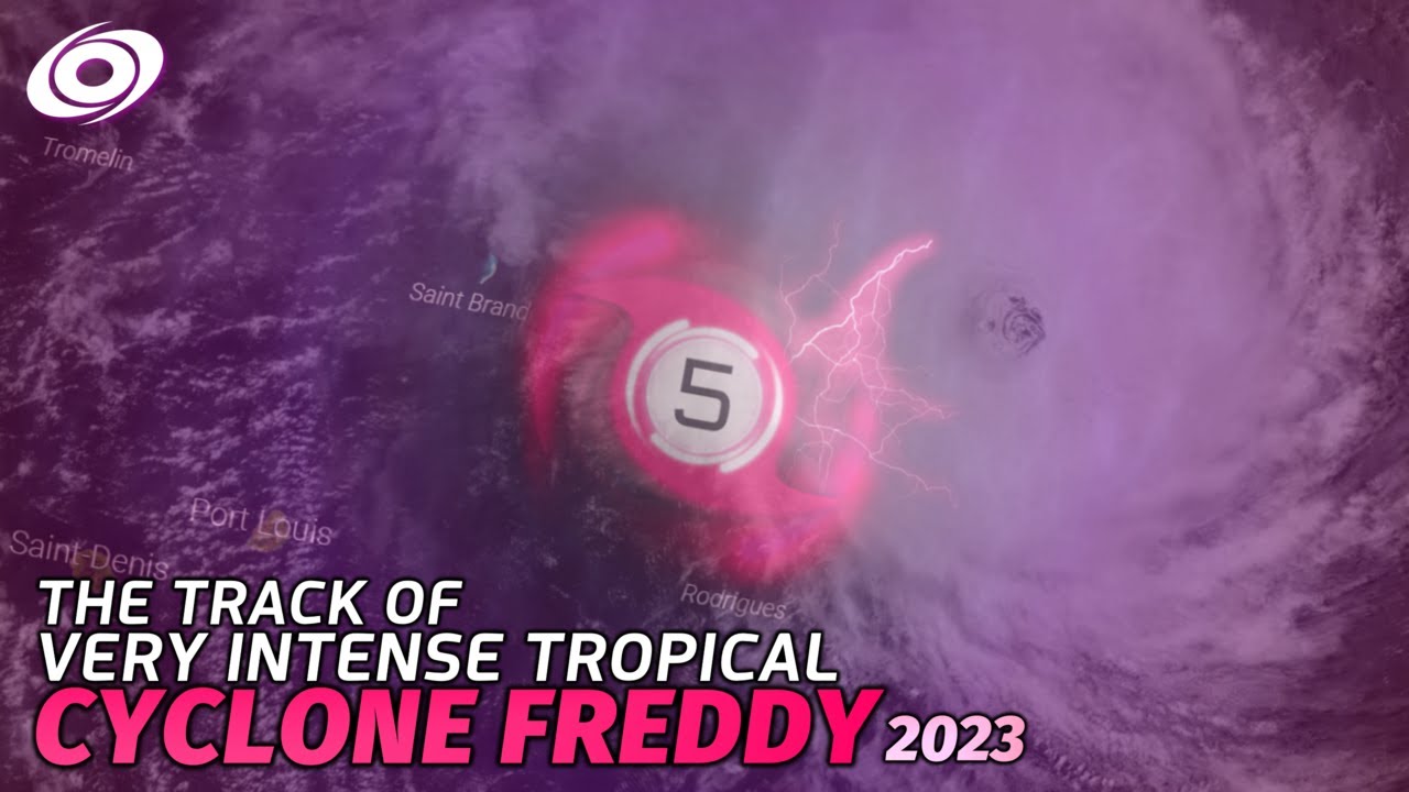
Cyclone Freddy was the fourth named tropical cyclone of the 2022-23 Australian Cyclone Season, and the second very intense tropical cyclone of the 2022-23 Southwest Indian Ocean Cyclone Season.
Freddy was an extremely unique and rare system breaking many tropical cyclone records. Such as the longest lasting tropical cyclone ever recorded, surpa...
@normal frost oh hey they did the thing
lets go
any tropical agency try not to underestimate their own area of responsibility challenge
DUDE
RIGHT AS YOU SAY THAT
A. TYPHOON 07W (LAN)

B. 10/1430Z

C. 26.07N

D. 143.00E

E. ONE/HMWRI9

F. T4.5/4.5/D1.0/24HRS  STT: S0.0/03HRS

G. IR/EIR

H. REMARKS: 01A/PBO EYE/ANMTN. WMG EYE SURROUNDED BY MG YIELDS AN
E# OF 4.5. ADDED 1.0 EYE ADJUSTMENT FOR B, TO YIELD A DT OF 5.5.
MET YIELDS 5.0. PT YIELDS 4.5. DBO PT.

I. ADDITIONAL POSITIONS:
   10/1109Z  25.95N  143.10E  MMHS
   10/1157Z  26.05N  143.08E  MMHS


PETERSEN```T4.5????????????????
👀
it prolly is


when the dora

its still holding its own
coming back to life?
banger af
frfr
storms like these I love
🔥🔥🔥🔥
I can cheer for the storm without looking like a psychopath
REAL

freddy flashbacks...........
yeah
and then you notice the 1400 death toll
until it did its thing,,,,
😔
gdi freddy
may they rest in peace
☠️☠️☠️

7 hours ago btw @normal frost
dora rly did improve a fk ton
yep
@normal frost
TCSWNP

A.  07W (LAN)

B.  10/1730Z

C.  26.3N

D.  142.9E

E.  ONE/HIMAWARI-9

F.  T6.0/6.0

G.  IR/EIR/SWIR

H.  REMARKS...WMG EYE SURROUNDED BY A B RING AND EMBEDDED IN LG YIELDS
A DT OF 6.0 AFTER ADDING A 1.0 EYE ADJUSTMENT. THE MET IS 5.5 BASED ON
A RAPID DEVELOPING TREND. THE PT AGREES WITH THE MET. THE FT IS BASED
ON THE DT.

I.  ADDL POSITIONS

    NIL


...GATLING```ok they fixed something good
now to see if their estimate is good
07W LAN 230810 1800 26.3N 142.9E WPAC 100 949
WTPQ50 RJTD 101800
RSMC TROPICAL CYCLONE ADVISORY
NAME  TY 2307 LAN (2307)
ANALYSIS
PSTN  101800UTC 26.3N 142.9E GOOD
MOVE  NNW 06KT
PRES  950HPA
MXWD  085KT
GUST  120KT
50KT  70NM
30KT  240NM NORTHEAST 180NM SOUTHWEST```
👁️
👀

@normal frost
hoyl
also both c4s self destructed LMAO
Lan said dry air and upwelling is yummy
NAURR


its 30/50
💀
EP, 05, 2023081118, , BEST, 0, 148N, 1786W, 95, 968, HU, 64, NEQ, 20, 10, 10, 20, 1011, 80, 20, 0, 0, E, 0, , 0, 0, DORA, D,
dora is now not a major
joever...

@normal frost
RSMC TROPICAL CYCLONE ADVISORY
NAME  TY 2308 DORA (2308) FORMER HR
ANALYSIS
PSTN  120000UTC 15.5N 180.0E GOOD
MOVE  WNW 16KT
PRES  975HPA
MXWD  080KT
GUST  115KT
50KT  30NM
30KT  120NM NORTH 90NM SOUTH```

HONEEEEEEEEEEEE
wdym


is this the bagel we seek

99E
if it forms too slowly, hone
hone slow down pls

yes!!!!


lan reintensifying ig?
wonder what it'll peak as

this shit might actually be named before reaching cpac ngl @normal frost
its 80/90 rn per nhc
EP, 99, 2023081312, , BEST, 0, 108N, 1356W, 25, 1009, LO, 34, NEQ, 0, 0, 0, 0, 1012, 150, 70, 0, 0, E, 0, , 0, 0, INVEST, S, 0, , 0, 0, 0, 0, genesis-num, 013,
man...

mfer has a core now wtf

wtf
...DEPRESSION STRENGTHENS INTO TROPICAL STORM GREG...
...NEXT ADVISORY WILL BE ISSUED BY THE CENTRAL PACIFIC HURRICANE
CENTER...


SUMMARY OF 1100 PM HST...0900 UTC...INFORMATION
-----------------------------------------------
LOCATION...11.3N 139.8W
ABOUT 1170 MI...1885 KM ESE OF HILO HAWAII
MAXIMUM SUSTAINED WINDS...40 MPH...65 KM/H
PRESENT MOVEMENT...W OR 275 DEGREES AT 13 MPH...20 KM/H
MINIMUM CENTRAL PRESSURE...1005 MB...29.68 INCHES
SOCIETY
society.
EP, 07, 2023081412, , BEST, 0, 157N, 1181W, 115, 955, HU, 64, NEQ, 20, 15, 10, 20, 1008, 140, 10, 0, 0, E, 0, , 0, 0, FERNANDA, D,
@normal frost
yow fernanda c4
yo?

that is fast
epac godmodule
How it's possible,?

what the
I'd assume it's measured in the middle of a runway

@normal frost the amount of things wrong with this track is staggering
but yeah
we have hilary
and its a hurricane now
very hilaryous
bitch
its AUGUST
WHERE IS IT GOING
dolly getting a visit from hilary
💀💀💀
im sure dolly will enjoy the rain
we can ask dolly herself for confirmation
@quiet mesa 

@normal frost yeaa actually we been getting random thunder storms this week
The weather has been very bipolar
^^^actually pinged because of this
Yeees haha

The hurricane is about to become opressed

Because its gonna touch cali
And its its gonna get fined for just being a hurricane

yea you've been praying for rain kek
Yeees
wtff
oof

lmfao
it sloppin
06L is expected to die soon
emily got cooked
(i didnt even notice that little shit formed LMAO)

WHAT IS BRO COOKING
LET GERT COOK
how did this little shit get named 😭😭😭

anyways have this
also like

this is emily


What happens where you let a 5 year old and their crayons take the reigns at ECMWF - on of the wilder spaghetti plots I’ve seen
💖 38
thats certainly a plot of all time.
surprise

@normal frost designated!!!!!
they decided to not sleep anymore
also jma gw

08w^^
wew
bro really went nah i dont wanna hit the philippines
WTPQ50 RJTD 240600
RSMC TROPICAL CYCLONE ADVISORY
NAME  TS 2309 SAOLA (2309) UPGRADED FROM TD
ANALYSIS
PSTN  240600UTC 20.2N 124.5E FAIR
MOVE  NNW 06KT
PRES  1002HPA
MXWD  035KT
GUST  050KT
30KT 150NM```@normal frost

also gw for 08w

lol L
bro thinks its an oval
it be like that
Dude we were just recording ourside me and my sister and suddenly it starts porring hard and we get a tornado warning
Michigan is crazy i am shocked
So loud
Another one😅

Ok we good
@normal frost

The look a storm usually gets before it goes apesh*t - this one’s gonna be a humdinger. Greater than usual track uncertainty still exists and because I have to suffer JMA’s latest graphic design abomination, you can too!
yikes
yea this track is getting p goofy
even models dont know the fuck its doing

wtf is happening
9 typhoons in a row btw 💀

uni + hosting an event on another server +cosplay shenanigans


😇
jtwc overrided 12z to 95 kts wtf
mfers really following SAR and throwing everything else out
jtwc pls

@normal frost franklin starting to cook?

saola is cooking hard
(please go away from the philippines)

With recent bursts of deep convection near its center and the latest microwave data already showing a formative inner core, TS #Damrey in the open WPAC looks to be on its way to becoming a typhoon. A buoy (ID: 5102808) also recorded a 986mb SLP just east of the center at 02Z.
breaking news: slop discovers how to not slopify


fair

@normal frost somehow both jma and jtwc got a DT of 2.5 from this
not sure how to feel about that, but okay
RSMC TROPICAL CYCLONE ADVISORY
NAME  TY 2309 SAOLA (2309)
ANALYSIS
PSTN  261800UTC 17.2N 122.9E GOOD
MOVE  S SLOWLY
PRES  935HPA
MXWD  100KT
GUST  140KT
50KT  50NM
30KT 150NM SOUTHEAST 90NM NORTHWEST```5 kt off VTY

stay safe guys
TCSWNP

A.  08W (DAMREY)

B.  27/0530Z

C.  33.6N

D.  146.0E

E.  THREE/HIMAWARI-9

F.  EXTRATROPICAL

G.  IR/EIR/VIS

H.  REMARKS...THE SYSTEM APPEARS TO HAVE BEGUN ITS EXTRATROPICAL
TRANSITION. THIS WILL BE THE FINAL BULLETIN UNLESS THE SYSTEM REGAINS
PURELY TROPICAL CHARACTERISTICS.

I.  ADDL POSITIONS

    NIL


...COVERDALE```@normal frost ????????????
what the Fuck is this fix supposed to mean

extratropical my ass
smap passed btw

meanwhile jma still thinks this is 45 kts
motherfuckers literally have CI 2.5 rn like ??????????
yea theyre trolling

i kid you not
they fixed
another 2.5
for 12z
i am at a loss for words rn
aint no way
but hey, on the bright side:
08W DAMREY 230827 1200 35.7N 144.4E WPAC 65 977
also irwin got named in epac

TCD issued by NWS EP5 at 27 Aug 2023 15:00 UTC
not expected to do much
franklin is now a c2
115 kts peak forecast if im not mistaken?

what
truly a Track.
one of the tracks of all time

@normal frost like
now that i think about it
this track + forecast
looks an awful lot like the downtown mrt line in singapore LOL
but shorter
💀
idalia named
in natl
expected to hit florida as a hurricane
@normal frost ok gfs is omega drunk

what the Fuck did i just watch
what the FUCK is happening
2 japan landfalls, 1 china landfall and a really dumb fujiwhara effect
and the fact that saola is the one that survives that fujiwhara
💀
truly a Run.

@normal frost

please tell me this thing isnt trying to become another fucking winnie
its too fucking cursed at this point
lolwut

@normal frost THIS IS A RED ALERT
THIS IS A RED ALERT

CPAC DISTURBANCE
HONE CHANCE IS REAL
on another note

franklin finally going for it
WTF

@normal frost jtwc (and jma) i dont think this is 45 knots
also like

look at this bozo
yeah
@normal frost franklin is the first major of 2023 natl
its official

also uh
yikes.
oh no
issuing final warning for this
oh they did something
they are trolling so hard right now
WOW
something bad
ccc = central cloud cover
or basically storms with no eye
ha?

Hold up... what????
#Saola

CCC is characterized by a large mass of cirrus spreading over the storm coming from one or a few intense convective cells with overshooting tops and reduced spiral banding, its a sign that intensification of a TC has stalled due to wind shear, when looking for CCCs you have:
- a reduction in spiral banding
- sharp edge of the convection in shear direction
- overshooting tops
copy paste
LOL