
#Meteorology
1 messages · Page 5 of 1


yep it is definitely trying


LMAO
96W INVEST 230517 0600 8.7N 135.1E WPAC 15 1010
woi
megastore atcf gamer
One of the more dramatic decouplings I’ve seen with a TC in the face of an increasingly poor environment. You can clearly see the storm’s tilt rapidly worsen as the mid-level eye get sheared cleanly off of its low-level…
@normal frost press F
@normal frost ooooooooof.
2023 really is out for blood
even fabien, a fish storm, capsized a ship
ouch.
@normal frost also
remember mocha
#BREAKING: Cyclone Mocha Fatality Total: 463
463 deaths
-460 in Myanmar
-3 in Bangladesh (indirect deaths)
101+ missing
-100+ in Myanmar
-1 in Sri Lanka
-719+ injuries
#wxtwitter #breakingnews #cyclone #mocha #CycloneMocha #cyclonemochaupdate #myanmar #Bangladesh
fuck.
yeahhhhh


Ah yes it's almost that time of the year

wpac awake time to run
o damn

This is the story behind one of the most famous tornado photos of all time. The Jarrell F5 Tornado Dead Man Walking Photo. Thanks for watching and be sure to subscribe for more tornado content.
Contents:
0:00 Intro
1:35 The Jarrell F5 Tornado
3:18 Double Creek Estates Tornado Damage
4:00 The Dead Man Walking Tornado Myth
5:30 Multi Vortex Torn...
!!
i love the jarrell tornado
for how interesting it is
have you seen an ef5 tornado
moving southwest
or any tornado for that matter


good structuring


02W MAWAR 230522 1800 10.5N 146.8E WPAC 100 960
alright im headed to sleep, gn
@normal frost but here's your major
Woi
oh yea I just noticed
if mega lurks #1071845487604404234
we can get him to translate stuff from meteo.france


02W MAWAR 230523 0600 11.8N 146.5E WPAC 135 926
bro
really?
both sab and jtwc went T7.0 and they still got that
💀
then again adt 6.8 and jma 6.5
jma, ,,
02W MAWAR 230523 1200 12.2N 146.1E WPAC 140 920
@normal frost
well

idk if this is c5 chief
scammed
2W MAWAR 230523 1200 12.2N 146.1E WPAC 135 923
AWA
ho

yikers

@normal frost LOL
THE EWRC RESULTED IN A PINHOLE
💀💀💀💀💀💀
on a very not nice note
guam is getting the southern eyewall rn

@crimewithbobby: A pickup truck was blown by strong winds from Typhoon Mawar in Guam
#TyphoonMawar #Mawar #Guam
holy shit
oh no
02W MAWAR 230524 1800 14.1N 144.1E WPAC 130 930
deadge
strengthening again now
at a decent rate
omw to tie my roof
oh hey guys i wonder what i woke up to

oh.
@normal frost they went 135 again btw

yu m
@normal frost hey
babe
- Mawar (2302) -
Location: 14.54N 142.82E
CI: 7.5 | DT: 7.5
MET: 6.5 | PT: 7.0
FT: 7.5```😳
babe wake up
jma just dropped t7.5
A. SUPER TYPHOON 02W (MAWAR)

B. 25/0530Z

C. 14.47N

D. 142.87E

E. ONE/GK2A

F. T7.5/7.5/D2.0/24HRS  STT: D0.0/03HRS

G. IR/EIR/VIS/MSI

H. REMARKS: 03A/PBO EYE/ANMTN. EYE EMBEDDED 80NM IN CDO YIELDS AN
E# OF 7.0. ADDED 0.5 FOR A WELL-DEFINED EYE TO YIELD A DT OF 7.5.
MET YIELDS 7.0. PT YIELDS 7.5. DBO DT.

I. ADDITIONAL POSITIONS: NONE


RAE```TCSWNP
A. 02W (MAWAR)
B. 25/0530Z
C. 14.5N
D. 142.8E
E. ONE/HIMAWARI-9
F. T7.0/7.0
G. IR/EIR/VIS
H. REMARKS...EYE PATTERN WITH A WMG EYE SURROUNDED BY CMG AND EMBEDDED
IN W FOR A DT=7.0 INCLUDING +1.0 EYE ADJUSTMENT. MET=6.5. PT=7.0. THE
FT IS BASED ON THE DT.
I. ADDL POSITIONS
NIL
...LEE```meanwhile

02W MAWAR 230525 0600 14.4N 142.8E WPAC 145 924
pressure doko
lol 924 for a 145
ikr

yeah

you thought that was cursed?
02W MAWAR 230525 1200 14.7N 141.6E WPAC 150 924
pressure doko???
pressure whatere
@normal frost
#Mawar is an extremely powerful typhoon - some stort-term weakening is likely due to an eyewall replacement cycle again, but restrengthening is likely after. Our forecast calls for a peak of 190mph, and a close pass to Luzon in 4-5 days. Some additional shifts are possible later.

are they actually forecasting 190mph
what the Fuck
wtf
WP, 02, 2023052518, , BEST, 0, 149N, 1405E, 155, 903, ST
@normal frost
SUSSY???
also finally not 924
when the nina is Dead
doesnt matter
nina still Died
also jma maintained 110 kt (koba)/910 mb
now that i have received this vital information
i shall now go Sleep
gn
o/
man
WHAT THE FUCK
i woke up to 185 mph mawar
didnt expect any more strengthening wtfff
@proven rain @normal frost
A. SUPER TYPHOON 02W (MAWAR)

B. 25/2350Z

C. 15.06N

D. 139.16E

E. ONE/GK2A

F. T8.0/8.0/D1.0/24HRS  STT: D0.5/03HRS

G. IR/EIR/VIS/MSI

H. REMARKS: 03A/PBO EYE/ANMTN. WELL DEFINED EYE EMBD IN 80NM
CDO, AND ADDED 0.5 FOR BF, TO  YIELD A DT OF 8.0. MET/PT AGREES.
DBO DT.

I. ADDITIONAL POSITIONS:
   25/1605Z  14.78N  140.72E  ATMS
   25/1631Z  14.87N  140.73E  GPMI
   25/1646Z  14.90N  140.62E  AMS2
   25/1656Z  14.85N  140.60E  ATMS


CVACH```T8.0
FUCKING
MAXED OUT DVORAK
no wonder they went 160

jma went 115 kts koba-10m
905 mb
for jtwc
...
02W MAWAR 230526 0000 15.1N 139.3E WPAC 160 897
sub 900.
sub 900.
¯_(ツ)_/¯
isnt an ewrc supposed to happen
the eye of Super Typhoon #Mawar is one of the top 5 driest eyes ever recorded, up there with Goni (2020), Meranti (2016) and Nepartak (2015)

dry ass eye jesus
AWA
It's time

175

weakening now,,,,
u should pin this!!!!!
jk
(are you serious)

HAHAHAHAHA
mawar no longer cat5
well honestly
the fact that it held 135
even on an ewrc
is insane
yeah
joever


sus
still looks great from satelite tbh
yea
😩💦

gfs not on board yet tho
wouldnt be unusual for a june ARB system
(gonu 2007, vayu 2019, nisarga 2020)
@normal frost wtf
TIL the 1973 flores cyclone didnt get any warnings
because forecasters werent sure there was even a cyclone there due to lack of observations
...until an eye appeared
...right before landfall.
yeah
it also didnt get a name
but idk why (might have smth to do with not being in aus AoR tho)
there's no TCR about it either, just a BoM track with literally only 4 points
apparently the death toll didnt even reach the Australian press until a month later
man looking for any info about this storm is hard
Lost broadcast footage of 2011 Joplin EF5 Tornado
https://youtu.be/FagzNHuI5JI

Unedited video capture of NBC affiliate broadcasting live from the west side of Joplin, MO from 5:25pm to 6:05pm on the terrible evening of May, 22, 2011. The Joplin tornado is reported to have been on the ground for 38 minutes, from 5:34pm to 6:20pm.
The screen freezes multiple times during this recording, including all of the last 19 minutes...
GAH DAMN
It feels like an analog horror
if that were me i'd sht my pants
I have been trying to find an old newspaper in my old place about the Xenia, Ohio, F5 tornado of April 3, 1974

Dam that's too unsettling for me 😂
😭
But this is cool to see
Great documentation 👌
This is when I got hit by an EF2
https://youtu.be/Iv4kCxlLwc0

Those who rode out the Monday night tornado that ripped through the Buncombe Creek Marina in Kingston are now dealing with the aftermath.
💀


lol scuffed
cane
tomorrow will be the 10th year since the el rino tornado happened
because funny damage indicators!!!!!!!!!!

uhhhh
Hmmm
It feels like its staring at me
o7


??
it became TD 02L
took long enough
was originally forecast to become short lived TS
but uh
it aint happening anymore
💀
KEKW
istg
if 03L doesnt end up getting a name
then this season is doomed
https://media.discordapp.net/attachments/716215692617187328/1114209369517740052/goes16_vis_meso2.gif

also meso jumpscare
anyways

At 06Z (2 PM Manila time) today, TS #Mawar (ex-#BettyPH) has reached an Accumulated Cyclone Energy (ACE) of 56.2 - now having the 12th highest ACE value in the Western Pacific basin in recorded history, surpassing TY "Joan" (1997) with 55.7.
For statistics purposes, here are the…
somewhat interesting
@normal frost wait
apparently
nhc is blending dvorak with recon rn
Bruh
ANJING

Why the NHC has not upgraded #02L to a TS yet is a mystery to me. The current recon mission has found evidence of TS-force winds (46KT FL at 925mb & >35KT SFMRs), ASCAT sampled multiple 33KT wind vectors overnight + a buoy recorded 33KT sus. winds yesterday.
Should be Arlene.
@normal frost
@normal frost oh it got named lol
tbf there's a surprising amount of c5s with an A name
anita, allen, andrew

🤓

not again

slop forming ic

funky clouds
this is like one of my hobbies
just looking through tornado path and damage indicators

WHAT
im not sure that's legal chief
that place is drier than a fuckin desert how tf
real
i think a storm will form, signal's been consistent for a while now
but no way it makes it to there lol
@normal frost TFCA.

MSGID/GENADMIN/JOINT TYPHOON WRNCEN PEARL HARBOR HI//
SUBJ/TROPICAL CYCLONE FORMATION ALERT (INVEST 92A)//
RMKS/
1. FORMATION OF A SIGNIFICANT TROPICAL CYCLONE IS POSSIBLE WITHIN
A 130 NM RADIUS OF 11.0N 66.1E WITHIN THE NEXT 12 TO 24 HOURS.
AVAILABLE DATA DOES NOT JUSTIFY ISSUANCE OF NUMBERED TROPICAL
CYCLONE WARNINGS AT THIS TIME. WINDS IN THE AREA ARE ESTIMATED TO
BE 25 TO 30 KNOTS. METSAT IMAGERY AT 051230Z INDICATES THAT A
CIRCULATION CENTER IS LOCATED NEAR 11.0N 66.1E. THE SYSTEM IS
MOVING NORTH-NORTHWESTWARD AT 04 KNOTS.
2. REMARKS: THE AREA OF CONVECTION (INVEST 92A) PREVIOUSLY LOCATED NEAR
10.8N 66.6E IS NOW LOCATED NEAR 11.0N 66.1E, APPROXIMATELY 826 NM SOUTH
OF KARACHI. ANIMATED MULTISPECTRAL SATELLITE IMAGERY DEPICTS A RAPIDLY
CONSOLIDATING LOW-LEVEL CIRCULATION (LLC) WITH FORMATIVE DEEP CONVECTIVE
BANDING WRAPPING INTO A WELL-DEFINED CENTER. A 050910Z AMSR2 89GHZ
MICROWAVE PASS FURTHER REVEALS FRAGMENTED DEEP CONVECTIVE BANDING TIGHTLY
WRAPPING INTO A SMALL COMPACT SYSTEM. ENVIRONMENTAL ANALYSIS INDICATES A
FAVORABLE ENVIRONMENT WITH STRONG DIVERGENCE ALOFT AND LOW VERTICAL WIND
SHEAR. SST VALUES ARE VERY WARM (30-31C) AND SUPPORT FURTHER
INTENSIFICATION. GLOBAL MODELS INDICATE RAPID CONSOLIDATION WITH A SLOW
POLEWARD TRACK OVER THE NEXT TWO DAYS. MAXIMUM SUSTAINED SURFACE WINDS
ARE ESTIMATED AT 25 TO 30 KNOTS. MINIMUM SEA LEVEL PRESSURE IS ESTIMATED
TO BE NEAR 1002 MB. THE POTENTIAL FOR THE DEVELOPMENT OF A SIGNIFICANT
TROPICAL CYCLONE WITHIN THE NEXT 24 HOURS IS HIGH.
3. THIS ALERT WILL BE REISSUED, UPGRADED TO WARNING OR CANCELLED BY
061300Z.
//
NNNN```oh wow
looks like we have something on our hands
ill read that later im teaching chowtiwat jong LOL


yum
@normal frost oh hey
its designated now
pretty nice looking depression, don't ya think?

but anyeays 70 kts prelim peak forecasted
@normal frost
only in the NIO do you see this tomfoolery
92A INVEST 230606 0600 11.9N 65.8E IO 50 994
50 kts invest!!!!


RSMC TROPICAL CYCLONE ADVISORY
NAME  TS 2303 GUCHOL (2303) UPGRADED FROM TD
ANALYSIS
PSTN  061200UTC 12.8N 134.8E FAIR
MOVE  ALMOST STATIONARY
PRES  1002HPA
MXWD  035KT
GUST  050KT
30KT  240NM EAST 180NM WEST
@normal frost
finally


now!!!!!
WOI
@normal frost
[Override]
02A TWO 230606 1200 12.2N 66.0E IO 70 982
02A TWO 230606 0600 11.9N 66.0E IO 55 992
woah
wao
Latest SMAP pass on #Biparjoy suggest that its sheared and elongated IR appearance is misleading and being underestimated significantly by satellite and objective estimates.
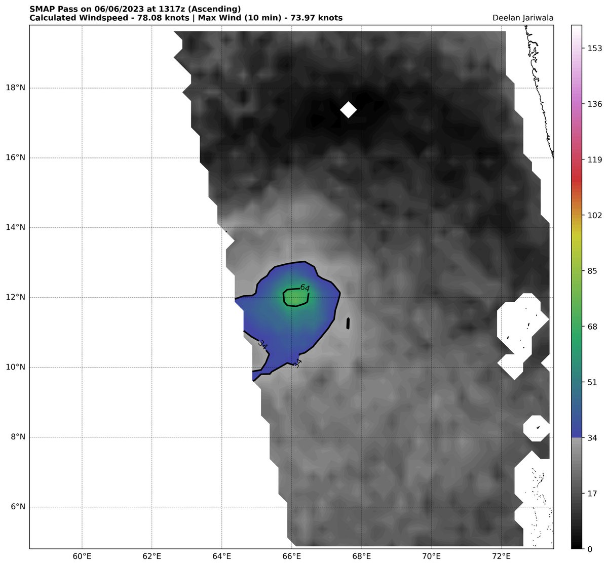


@normal frost seems to be the main justification
thanks imd!!!!!!


very
its even smaller than it looks
you can see from jtwc or smth

bro wtf
TPIO10 PGTW 070922

A. TROPICAL CYCLONE 02A (BIPARJOY)

B. 07/0830Z

C. 13.18N

D. 66.16E

E. THREE/MET9

F. T5.0/5.0/D2.0/24HRS  STT: D0.5/03HRS

G. IR/EIR/VIS/MSI

H. REMARKS: 22A/PBO SMALL CDO/ANMTN. WELL-DEFINED CDO OF 75NM IN
DIAMETER YIELDS A CF OF 3.0. ADDED 2.0 FOR BF TO YIELD A DT OF 5.0.
MET AND PT YIELD 4.5. DBO DT.

I. ADDITIONAL POSITIONS:
   07/0439Z  13.12N  66.32E  CWVR


   PETERSEN
damn T5.0
meanwhile imd at T4.0 🥱
wait its 2 degrees big
💀
but interesting
c3 peak
fr its SO SMALL
also mmm
we're getting quite a lot of majors
I cannot believe nio is active
real
making up for 2020-22 🔥
so TRUE
we started talking about storm systems 2 years ago we are finally getting a spicy season
indeed

also guchol

meanwhile biparjoy
yum

thats c2 btw
02A BIPARJOY 230607 1800 13.8N 66.1E IO 85 970
12z was also 85
guchol at 60 btw
anyways ima head to sleep now cya
gn

le shrimp


zamn

bruhhh
El Niño conditions are present and are expected to gradually strengthen into the Northern Hemisphere winter 2023-24. An #ElNino Advisory is now in effect. https://t.co/5zlzaZ0D9Z
Likes
413
Retweets
268

el nino.
nino.
 warm climate for northern Russia

giga nino
😔
@normal frost
02A BIPARJOY 230609 1200 15.3N 67.4E IO 65 983
03B INVEST 230609 1200 19.9N 91.8E IO 40 995
one of these is not like the other (tc jumpscare kinda)

also tc jumpscare?
jumpscare
o
[Override]
02A BIPARJOY 230610 1200 17.1N 67.5E IO 105 961
02A BIPARJOY 230610 0600 16.9N 67.4E IO 100 966
@normal frost sar'd
02A BIPARJOY 230610 1800 17.4N 67.5E IO 105 946


BRUH
biparjoy try to maintain a core challenge
@normal frost can u add this in resources btw
@normal frost also we should probably unpin this LOL
you did iy

unpinned
also like
imagine going into the thread and
presses pins
"fuck madagascar"
YEAH LOL
very epic

uh oh
o h


hail cuck
👀

@normal frost Uh
zamn if i put cheese on top of that i wonder if it'd taste good
LMAO
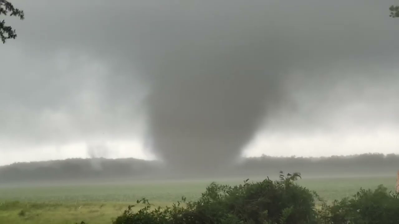
Newton Georgia Massive wedge tornado intercepted in southwestern Georgia during major tornado outbreak Dixie Alley in June. Dominator 3 was inside at birth! Drone in the air and micro pressure data recorded. Tornado outbreak continues.
00:00 - tornado in Newton Georgia on the ground
02:40 - tornado continues
03:47 - Jordan hall shooting drone
wao
#EarthquakePH #EarthquakeBatangas
#iFelt_BatangasEarthquake
Earthquake Information No.1
Date and Time: 15 June 2023 - 10:19 AM
Magnitude = 6.2
Depth = 103 km
Location = 13.82°N, 120.59°E - 004 km S 73° W of Calatagan (Batangas)

what the fuck
not meteorology but still
@atomic flint you good?
yea didnt feel it 💀
Same here
But I was talking to my classmate about me having dreams about earthquake in my school recently and didn't expect the same thing to happen
What are the odds man?
Just right after I finished telling my dream experience, the earthquake alert suddenly came

wtf
bro foreshadowed events
had to put a reminder🤷
Hu?
@normal frost what the fuck
i just found one of the storms of all time

cyclone keli of 1997
formed in spac
looks normal at first
until you realize when it formed
june 7 - 17 💀💀💀💀💀
???
@normal frost 92L
yum

yeah, biparjoy stilll chugging 💀

ho?

BRUH
epic embed fail

we've been having a pretty bad drought
it was kinda scary seeing literally all of the grass around our house turning yellow

bottom map shows the drought affected regions
namely red being more severe than the yellow
but i'm in a yellow zone
top map is "Risk of spontaneous fires"
orange is High Risk and red is Extremely High Risk

flop
also 0/70 in epac
yeah

flop ass
04L not yet named either

epac signal still 0/70 afaik
92w and 93w are a thing
latter has a decent chance apparently
huh

flop

LOL

looks kinda shit for 50kt lol

WOI
EP, 91, 2023062718, , BEST, 0, 153N, 1056W, 40, 1002, DB, 34, NEQ, 20, 40, 30, 20, 1008, 100, 20, 0, 0, E, 0, , 0, 0, INVEST, M, 0, , 0, 0, 0, 0, genesis-num, 004,
@normal frost
adrian
latest start on record btw


let him cook
01E ADRIAN 230628 1200 15.2N 107.8W EPAC 65 989
92E INVEST 230628 1200 11.1N 94.8W EPAC 20 1008
@normal frost
epac got a hurricane before natl
🔥🔥🔥🔥🔥
natl floppers
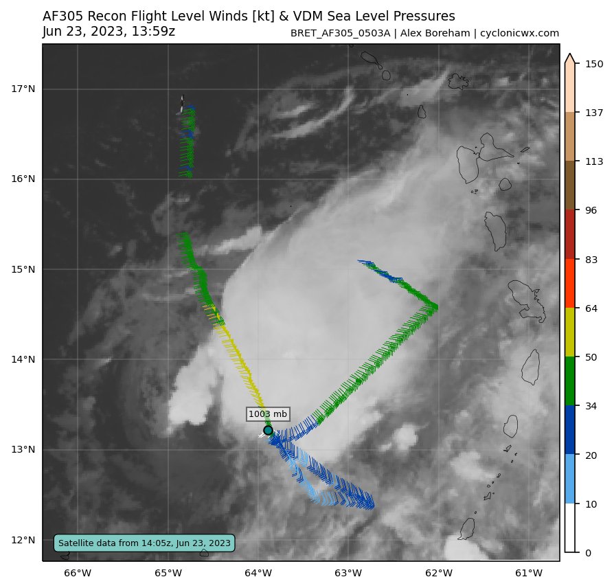
tho honestly
bret might've become a minimal hurricane
recon kinda supports
¯_(ツ)_/¯
frfr
01E ADRIAN 230629 0600 15.4N 109.5W EPAC 75 982
@normal frost
good chance it'll hit c2
wonder if it'll reach c3 tho
NOOOOOO

@normal frost
so ur telling me this thing
is estimated by the nhc
to be...90 mph?
they blended a T.5 and a T4.5
to...80 kts
💀
also we have beatriz

@normal frost
idk about u
but if that's a genuine core
please be
nhc hates epac
EP, 01, 2023063006, , BEST, 0, 166N, 1115W, 85, 973, HU, 64, NEQ, 15, 15, 10, 15, 1008, 200, 10, 0, 0, E, 0, , 0, 0, ADRIAN, D, 0, , 0, 0, 0, 0, genesis-num, 004,
c2!!!
epic!!

wew

@normal frost 95.
for adrian
😭😭😭😭😭😭
its joever
beatriz seems to have gotten the Shear
its so joever
MAN
wtf
@normal frost beatriz peaked as well
recon went into it a while ago
75 kts 992 mb 💀
that pressure is retarded
exactly!!!!
when the pressure is sus
wpac is...asleep
natl as well
epac might get a 3rd storm if the models are to be believed
moment

L
double rainbow

it was veeery prominent
i haven't seen such a bright rainbow before
I've only ever seen one double rainbow before. I lost the pic though
wao
goddamn


funni
this looks ridiculous LOL
it rly does
nio moment
mocha biparjoy wombo combo fr
ho
td 03E
epico
ts calvin
50 mph now
KEK
🙏

LMAOO
anyways
hurricane calvin
we are now 3/3/0
||we dont talk about 93E's amazing 90/90 bust||
yea
we'll see i guess
im just curious whats gonna be the strongest storm this natl season ngl

calvin major inc!!!!

@normal frost hey man here's a 90 kt cat 2
take it or leave it
- nhc
EP, 03, 2023071406, , BEST, 0, 131N, 1211W, 90, 970, HU, 64, NEQ, 20, 0, 0, 10, 1008, 160, 20, 0, 0, E, 0, , 0, 0, CALVIN, D, 0, , 0, 0, 0, 0, genesis-num, 007, ```good job e
MAN
meanwhile
94L
AL, 94, 2023071406, , BEST, 0, 327N, 467W, 45, 1002, LO, 34, NEQ, 120, 180, 0, 0, 1013, 210, 60, 0, 0, L, 0, , 0, 0, INVEST, M, 0, , 0, 0, 0, 0, genesis-num, 013,
45 kt invest
!!!!!
meanwhile...

🤨
and finally
95W tfca
all 4 nhem basins having signs of activity
what a time to be alive
||cpac doesn't exist||
hone soon !!!
@normal frost
Subtropical Storm Don Advisory Number 1
NWS National Hurricane Center Miami FL AL052023
500 AM AST Fri Jul 14 2023
...SUBTROPICAL STORM DON FORMS OVER THE CENTRAL ATLANTIC...
SUMMARY OF 500 AM AST...0900 UTC...INFORMATION
LOCATION...32.9N 46.8W
ABOUT 1165 MI...1875 KM WSW OF THE AZORES
MAXIMUM SUSTAINED WINDS...50 MPH...85 KM/H
PRESENT MOVEMENT...N OR 360 DEGREES AT 6 MPH...9 KM/H
MINIMUM CENTRAL PRESSURE...1002 MB...29.59 INCHES
natl's 5th storm
5/0/0 rn 💀
yea

90kt guys trust me


04W FOUR 230714 1200 16.8N 118.9E WPAC 25 998
@normal frost
EP, 03, 2023071412, , BEST, 0, 134N, 1225W, 100, 963, HU, 64, NEQ, 25, 15, 15, 25, 1008, 180, 15, 0, 0, E, 0, , 0, 0, CALVIN, D, 0, , 0, 0, 0, 0, genesis-num, 007,
MH CALVIN!!!!!!
3/3/1 now
HAH
...CALVIN RAPIDLY INTENSIFIES INTO A MAJOR HURRICANE...
SUMMARY OF 500 AM HST...1500 UTC...INFORMATION
LOCATION...13.6N 123.2W
ABOUT 1080 MI...1740 KM SW OF THE SOUTHERN TIP OF BAJA CALIFORNIA
MAXIMUM SUSTAINED WINDS...120 MPH...195 KM/H
PRESENT MOVEMENT...W OR 280 DEGREES AT 16 MPH...26 KM/H
MINIMUM CENTRAL PRESSURE...960 MB...28.35 INCHES
@normal frost it official
they even went 105 kts
😳
LETS GOOOOO

spinny boy
we have talim @normal frost
activity lesg o
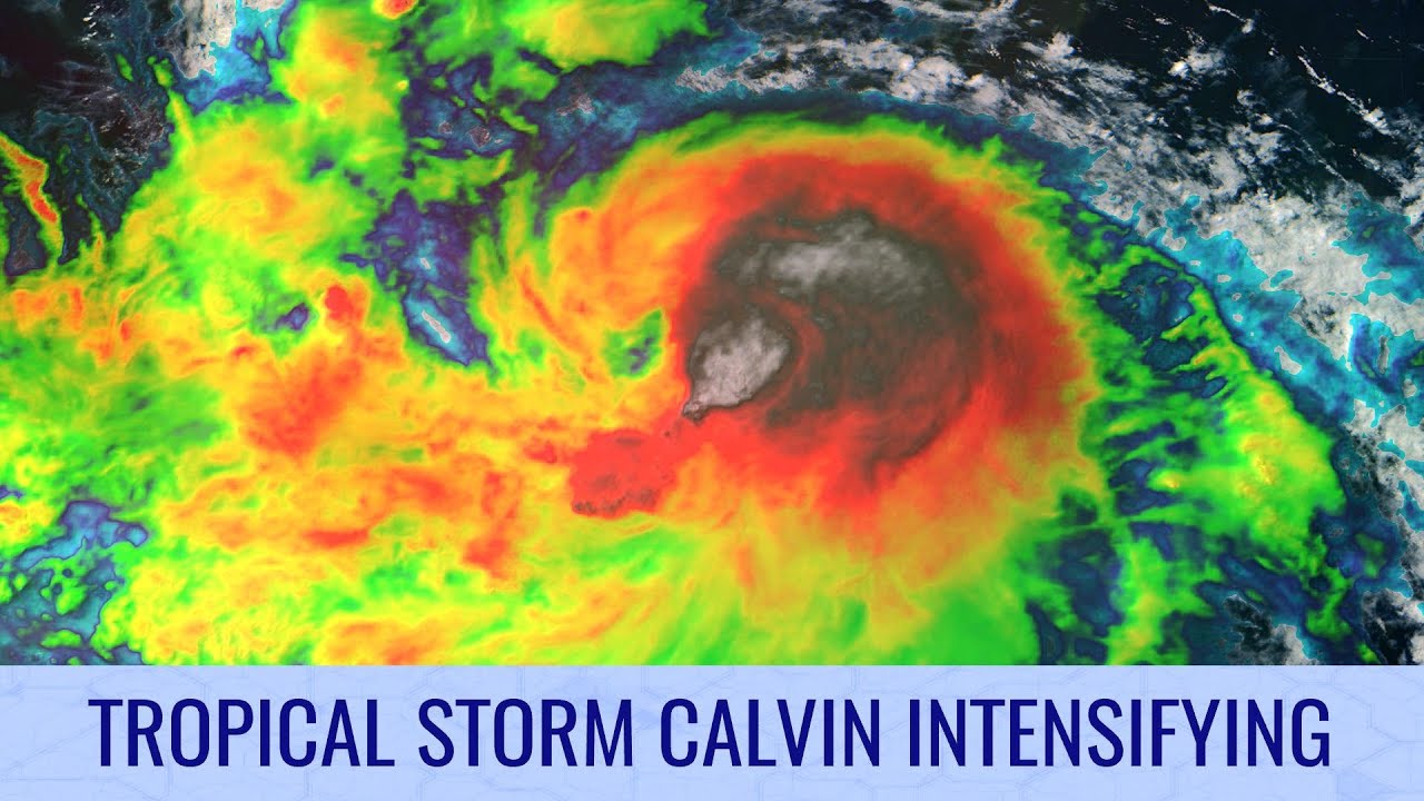
The tropics are getting a lot more active this week, first with the formation and fairly quick development of Tropical Storm Calvin, along with six other systems that have a chance of forming in the next seven days.
Tropical Storm Calvin is steadily intensifying, and is likely to become a hurricane later today or tomorrow. Models are suggesting...
@normal frost why does this have 700k views
💀

ikr

oh what the fuck


jma: ima give that an sts
(yes, they still have sts)
jtwc meanwhile downgraded it it 65 kts
H.
hah?

scs moment
oh btw
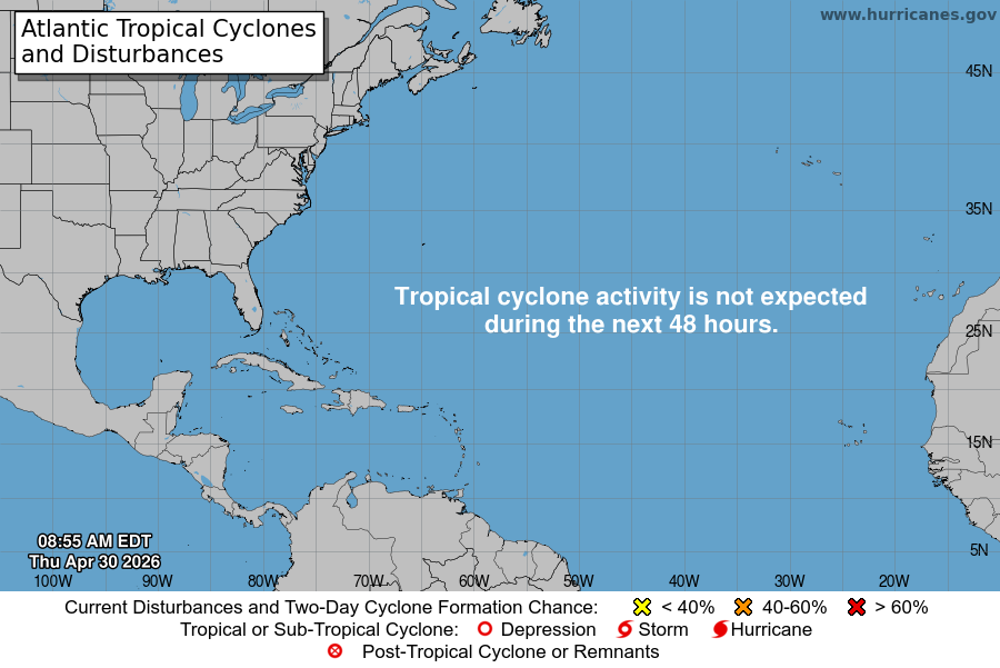
TROPICAL STORM CALVIN ENTERS THE CENTRAL PACIFIC...
...TROPICAL STORM WATCH ISSUED FOR HAWAII COUNTY...
SUMMARY OF 500 AM HST...1500 UTC...INFORMATION
LOCATION...16.8N 141.4W
ABOUT 920 MI...1480 KM E OF HILO HAWAII
ABOUT 1120 MI...1805 KM ESE OF HONOLULU HAWAII
MAXIMUM SUSTAINED WINDS...50 MPH...85 KM/H
PRESENT MOVEMENT...W OR 280 DEGREES AT 18 MPH...30 KM/H
MINIMUM CENTRAL PRESSURE...1000 MB...29.53 INCHES
WATCHES AND WARNINGS
CHANGES WITH THIS ADVISORY...
A Tropical Storm Watch has been issued for Hawaii County