#Meteorology
1 messages · Page 4 of 1
yike
@normal frost

lets GOOOOOO
wonder if its peaking now tho
or if it'll strengthen til 12z

also a 6z override
also 935 hPa


VIIRS Imagery of Cyclone Herman
03.31 0628Z
Eyetemp: 20.241028 Celsius


god Fucking Damn.
hoyl

he got a PDS warning

A Confirmed Tornado Warning with considerable damage potential has been issued for Tipton, Lauderdale, and Haywood Counties, Tennessee until 7:30 p.m.
brother
🙏
No tornado here, but we had some very close lightning
One of them was like 2 blocks away it was so loud
Storms just about over now only rain. I love lightning though was watching it for a while
Lightning is pretty cool to watch
ye

NOOOOOOOOO

oioi

MAN
btw idk if you saw @normal frost
The Tropical Cyclone Report for Hurricane #Ian (September 23-30, 2022) has been posted on the NHC website. Ian made landfall near Cayo Costa, FL as a category 4 hurricane, directly taking the lives of 66 people and causing $112.9 billion in damage.
Likes
638
Retweets
281

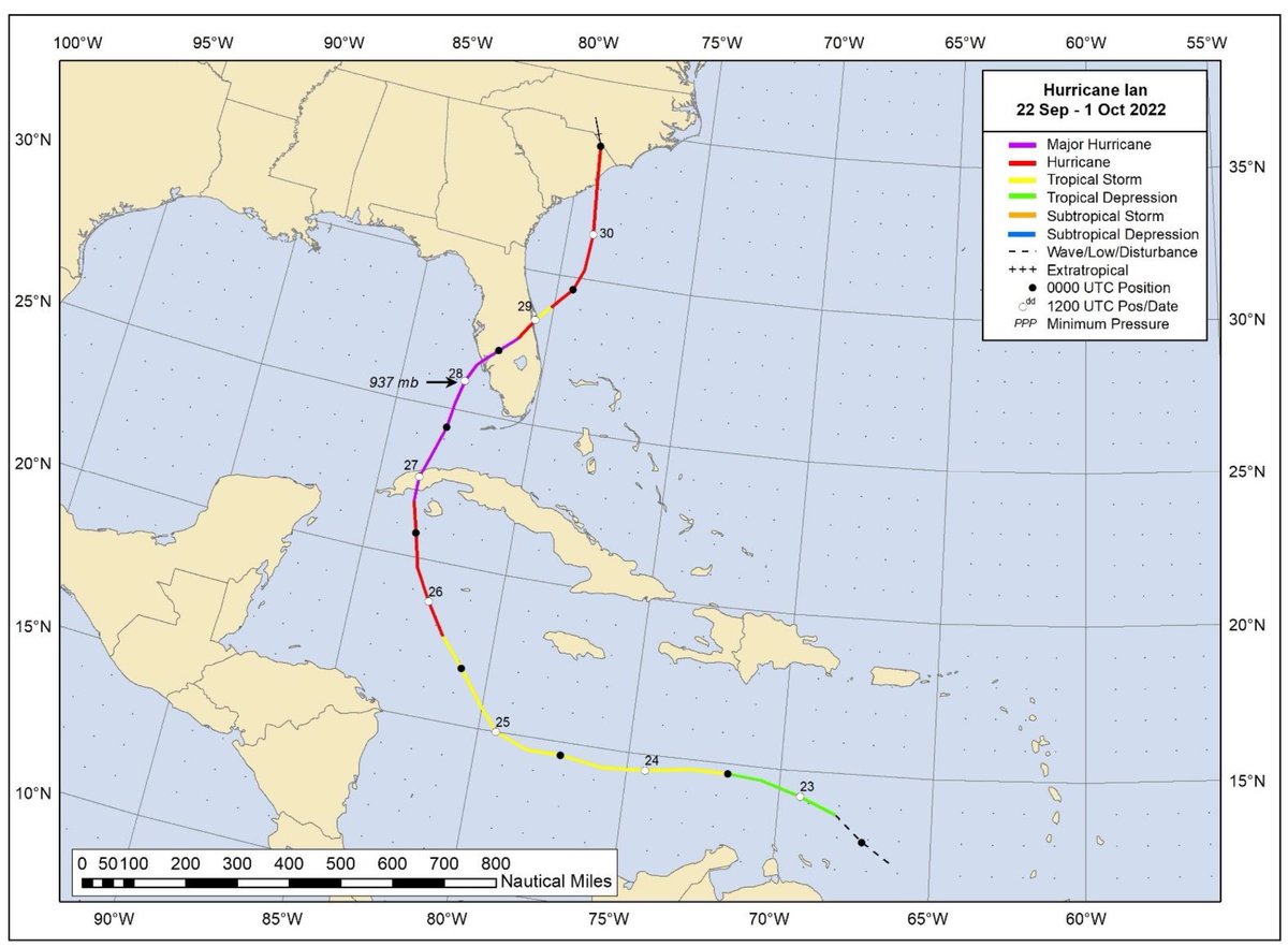

ian is now the first natl c5 since lorenzo


oh dear
@normal frost

imagine
would be hilarious if aus season caught up on named storms in fucking april
thanks gfs

bye ap
Just after the holy week LMAO
imagine if it made landfall
and caused class suspension
💀
💀


Download Radar Omega! Android: http://bit.ly/32sNK4U Apple: http://apple.co/3EqpNZfSupport the Y'all Squad here: http://www.shopryanhall.com/WANT TO BECOME A...
This Iowa and Illinois storm is pretty bad rn

yikes
Yea storm came back for another round..
😭
Stay safe my boi🙏


scary

bye ap
KEKW


@normal frost @tribal arch @proven rain can we Please Not


super el nino anyone.......?
maybeeeeee

we're about to experience storms stronger than fucking category 5 hurricanes
bc of this el nino shit
inb4 flop nino
fyi the strongest category is 5
even yolanda was a 5
nothing higher exists
Yeah ik ik
You still remember LMAO
Still I wonder what was the strongest wind gusts recorded in a tropical cyclone
its not the first time he said this
he does it every time he sees me and ap talk about storms
if it was 1 time i wouldnt care
isnt there records in wiki
patricia?
405km/h
im assuming
Olivia 1996
It's 409 km/h in some sites
if we want faster
el rino tornado
iirc it was like 480 something km/h
at its peak


Severe Tropical Cyclone Olivia was a powerful cyclone, the 13th named storm of the 1995–96 Australian region cyclone season, which formed on 3 April 1996 to the north of Australia's Northern Territory. The storm moved generally to the southwest, gradually intensifying off Western Australia. On 8 April, Olivia intensified into a severe tropical c...
Moment


Central pressures less than 900 are kinda rare
cursed
idrc about records this year because freddy provided gunga records
i just want a good nino season
thats it
@atomic flint question
Freddy hypercarry
give me your top 3 favorite storms that tou've tracked
@proven rain you too
ngl ap will prob say freddy and hinnamnor like me
because those are wacky funnies
I haven't tracked many storms since I'm still kinda new to this stuff but lemme see
Well
Goni, Freddy, and Rai
I guess that's it
Before I start to talk about storms on this server, I only tracked typhoons visiting PH

And now, I began to look at the other basins as well
why would you throw me such a hard question
😭
yeah freddy is definitely in that top 3
maybe gulab-shaheen as well
dont think ill be seeing anything like it for a while
for the last one...
maybe tokage????
@normal frost yea i guess i can go with this
freddy cuz highest ace + weird track
shaheen cuz extremely rare for cyclones to track into the gulf of oman
tokage cuz funny high latitude major
or maybe hinnamnor/chanthu instead of tokage???????? IDK
the other 2 are solid tho
oh actually raoni is also pretty interesting
june satl near-hurricane stc
¯_(ツ)_/¯
reminder that this exists

dayum

Donut
Maxi wejj
so much of a wejj the scale broke
Even larger than this
i think this is larger than tip actually
apparently it was so retarded that the model itself broke LOL
KEKW


yikes

23U "Nameless" 9.7S 129.3E 996 hPa 18 m/s

shh
Gl
@normal frost holy fucking shit?

jtwc forecasted 140 kts for the FIRST advisory
2nd cone was 130 tho
holy???


The Little Rock & Wynne Arkansas tornadoes on March 31, 2023. These tornadoes were moving roughly 50 mph leaving behind a wake of destruction.
NOT FOR REBROADCAST
COPYRIGHT PECOS HANK 2023
To license video contact [email protected]
LITTLE ROCK ARKANSAS TORNADO
On March 31 a Tornado Emergency was issued for Little Rock Arkansas
as a...
wake up new pecos hank video
my beloved
what the heck
Seems about right


damn
smh

is it just me or that storm moves slow af
https://cdn.discordapp.com/emojis/1062321746247696424.webp?size=48&name=skull_shock&quality=lossless

ehhhhh not rly
hmmm
if smth moves slow enough it'll upwell the waters around it to oblivion (which leads to weakening cuz that leads to colder waters)
or smth like that
oh ok
anyways this thing is taking a recurving track
gonna make landfall in 2 days
until that happens tho, near-perfect conditions + jet interaction for it

TC ADVISORY
DTG:                 20230413/0600Z
TCAC:                DARWIN
TC:                  ILSA
ADVISORY NR:         2023/21
OBS PSN:             13/0600Z S1842 E11848
CB:                  WI 150NM OF TC CENTRE TOP FL600
MOV:                 S 10KT
INTST CHANGE:        INTSF
C:                   930HPA
MAX WIND:            110KT
FCST PSN +6HR:       13/1200 S1936 E11854
FCST MAX WIND +6HR:  120KT
FCST PSN +12HR:      13/1800 S2024 E11942
FCST MAX WIND +12HR: 95KT
FCST PSN +18HR:      14/0000 S2112 E12100
FCST MAX WIND +18HR: 70KT
FCST PSN +24HR:      14/0600 S2200 E12242
FCST MAX WIND +24HR: 55KT
RMK:                 NIL
NXT MSG:             20230413/1300Z
@normal frost @proven rain @tribal arch c5 aus
way earlier than expected

ikr?
its the nino buff guys
its not even nino yet kekw

pls be super nino it will be funny
also there's still one more signal i believe


👀
135 kts in 1-min
or uhhh
i believe 250 kph?
yea
dude
about 250


ikr???
when the MW is nuclear
@normal frost also this keeps inching closer and closer to port hedland
population 10k 💀
hope they get ready for that storm surge
notlikethis
yea
things gonna hit at peak
the only question is how close they'll be to the eyewall
oh
worse comes to worse
it doesn't turn AND does an ewrc
apparently its ewrc prone rn
h.
h.
NOOOOOOOO
inb4 ewrc
nah it got dry air'd 💀
maintaining apparently tho
downgraded to 130kts now btw
as for BoM
TC ADVISORY
DTG:                 20230413/1200Z
TCAC:                DARWIN
TC:                  ILSA
ADVISORY NR:         2023/22
OBS PSN:             13/1200Z S1924 E11906
CB:                  WI 130NM OF TC CENTRE TOP FL600
MOV:                 SSE 08KT
INTST CHANGE:        WKN
C:                   928HPA
MAX WIND: 115KT```130kts as well i guess
obs supported too

phew
phew
@normal frost wtf
wha
f13 went 150 kts
WHA
i find it funny that this thread still has the most messages
more than the literal emote thread by 800 messages
Meteorology is pretty good
based
based
based

what the fuck lool
ha?
death
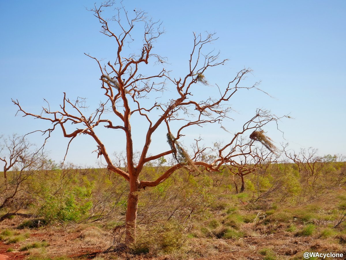
Defoliated and partially debarked trees from an area affected by the south-western eyewall of #Cyclone #Ilsa.


this is p wack


YAY

🤔

ayyy
kekw


Help me replace my windshield!
Hit the "Thanks" button and drop me a couple of bucks if you like the video, or Paypal me a buck to my email, below, if you like this video. My car might need a little work as well. I rode it hard and put it away wet, that day.
[email protected]
When the chaser gets chased: An EF4 is chasing me, and now I have...
this guys is why you should be really careful on stormchases
this guy is chad because he's new but admits to mistakes and doesn't scream like a bitch when chasing


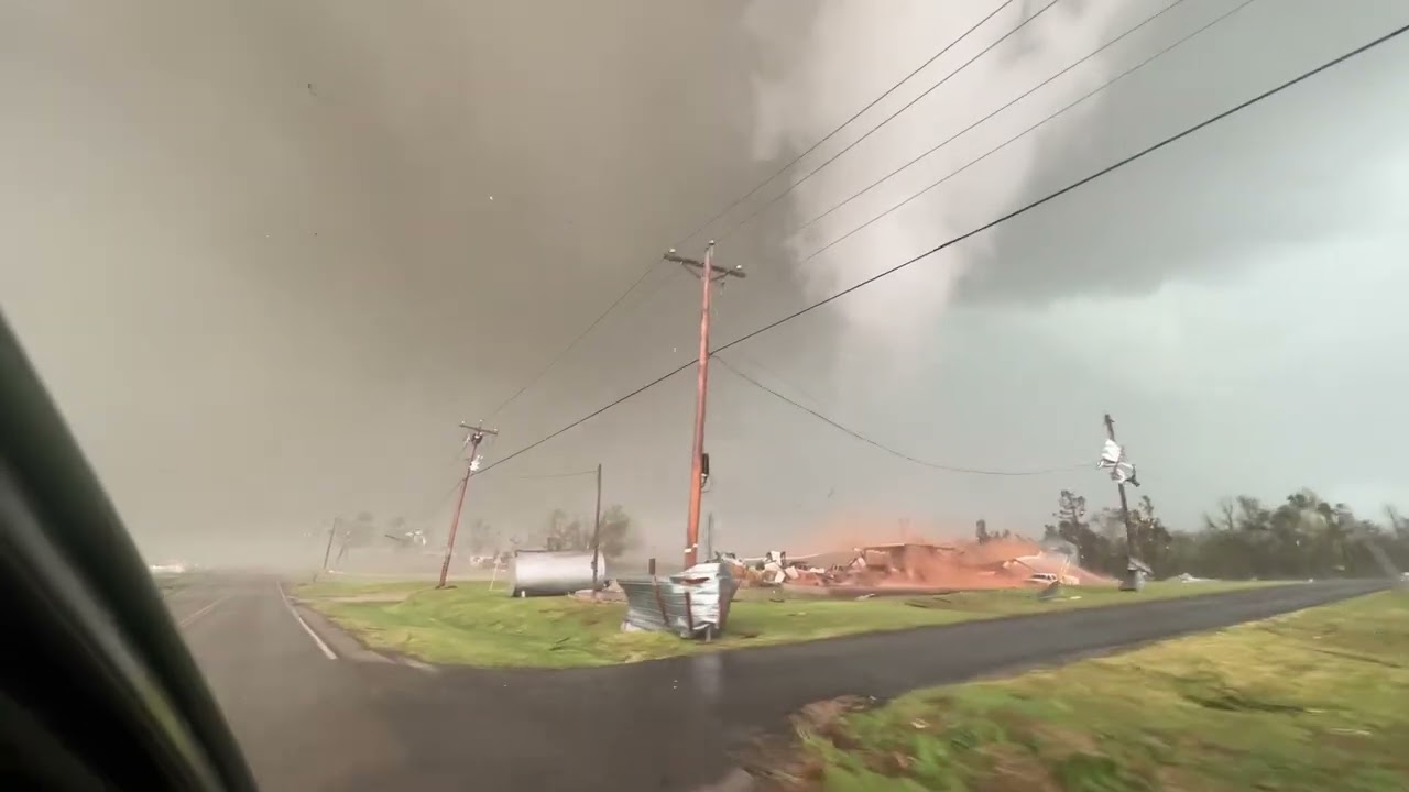
Powerful and tragically destructive tornado passes through Cole, Oklahoma. Subsonic sensor deployed west of torn. Dominator fire anticipated left hand turn and allowed the tornado to pass the road. Underground storm shelter in destroyed home. Search and rescue zone now
A EF3 Tornado that should have been classified as an EF5
Cole, Oklahoma
Tornado watching is pretty fun
^
ah yes
nws lowballing again
at this rate we're not getting another ef5 LOL
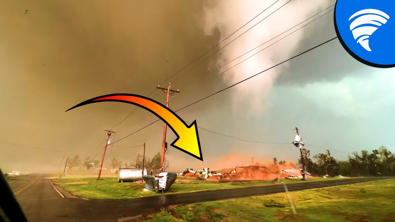
Dr Reed Timmer's footage of the Cole, Oklahoma tornado is now extended, enhanced, and explained step by step. This disaster had several strange things about it, including horizontal vortexes and multiple vortexes, not to mention the erratic path of the tornado. Drone footage also reveals the toll of this extremely strong tornado.
00:00 - Intr...
More detailed information about it

Agreed
nws what are you doing 😭
there's fr so many tornadoes that should've been ef5 but noooooo
here you go ef4
They like to add "+" to every major tornado
For example Rolling Fork, MS EF4+
Fujiwhara effect going crazy
goofy ass ef scale
Fr
i mean, its exciting but i kinda wanna live my life first
it's fun till it's suddenly approaching your direction
I studied tornadoes enough to tell lol
I still want to
I studied supercell formation for a reason 

Monster Baseball sized hailstone smashing my windshield right in front of my camera with tornado approaching.
NOT FOR REBROADCAST
COPYRIGHT PECOS HANK 2023
To license video contact [email protected]
On April 19, 2023 a tornado outbreak occurred in Oklahoma, Kansas and Iowa. The tornadoes in this video were near the towns Strong City K...
new pecos hank video
aware
I think I've sent this before but

Of the many tornadoes which touched down in the April 27, 2011 afternoon super outbreak, the Philadelphia, MS EF5 tornado was undoubtedly one of the most intense. Leaving behind trenches in the ground up to 2 feet deep, the sheer strength of this storm ensured it would not be forgotten.
From Wikipedia: During the afternoon of April 27, 2011, a ...
good documentary pls watch
(or just any vid from this channel)
Rainsville should've been ef5
I know that all too well
you live in the alley?
I do
wew
Most of my life
.......
wtf dox
I don't mind
🤨
oh it's just on the edge of the alley
hhh
I thought you live in like
nebraska
or smth
It is

More like forced

o h
tbh I want to stormchase at least once in my life
I've always been interested
but well
I live literally across the planet
One day you'll be able to
the real question is
I got to watch a mini supercell form a couple days ago
o
oh right it's late april already
tornado season!!!!!!
huh
we don't get tornadoes here
well not conventional ones at least
last time one appeared was like
7 years ago
even a weak one is a big deal here
Once you come over here they are as cool and scary
they are cool
I even studied the conditions for them LOL
that's how interested I am
Im glad you have a passion for meteorology👍

I need my hurricane season
True
I just try to predicted how many times Florida is going to get hit
💀
I forgot how long la nina was lol
lol
well to put it simply
el nino = warmer waters
la nina is the opposite
oh
that's what you meant
it was nina last year
it is neutral rn
models predict nino to start mid-late may
avg +2c which is actually quite big
Interesting
Freddy refused to die
😩

SITREP - This is live storm chase mode with “Panhandle Magic” possible today including threat of gorilla hail and an isolated tornado. Supercell initiation i...
hoho
This one has been going up and down
Ya but it dissipated in like 1min


Lol
He was the only one that I could find that was close to it
Reed is just as crazy as my last boss
I don't think this one will produce anything minor or major
trolled by dry air once again
But its still possible
True

SITREP - Today is an Enhanced Risk, and a monster hail and tornado threat all across the GREAT state of Texas. This is live storm chase mode from the Domina...
Another very likely tornado
Now its in a rain wrapped wall
I love constantly being at risk
when the tornado season:

Full Story behind my most insane and dangerous storm chase ever- the chase I was hit by the Lewistown IL EF3 tornado on April 4, 2023.
Featured Videos-
Styro_Drake
https://www.youtube.com/watch?v=zHHzhkRXGG8
Stas is Chasing
https://www.youtube.com/watch?v=Rh1R2YhZKQQ
0:00 - Intro
1:16 - Feb 26
2:59 - March 31 HIGH RISK
5:26 - April 4
8:42 -...
this kids is why you gotta stay calm and collected

wtf


what the fuck
@normal frost ok
shit is getting
VERY real
icon 912.
even navgem is onboard 💀

what gfs has
oh god oh fuck


oh dear

ye a


uh oh

DEPRESSION HAS FORMED OVER SOUTHEAST BAY OF BENGAL AT 1730 IST TODAY, THE 9TH MAY 2023. TO INTENSIFY INTO A CYCLONIC STORM ON 10TH MAY.
yum
What the weather cook'n
we have cyclonic storm mocha
Mocha
MOCHA

PNS issued by NWS NHC at 11 May 2023 15:00 UTC
@normal frost
subtropical storm 90L
Cyclonic storm Mocha intensified into Severe Cyclonic storm at 1730 IST of today .It lay centered near latitude 12.2 N and longitude 88.0 E about 520 km west of Port Blair 1100 km southwest of Coxs Bazar Bangladesh at 1730 hrs IST of today the 11th May


SCS Mocha

jesus that windfield


A. TROPICAL CYCLONE 01B (MOCHA)

B. 12/1130Z

C. 14.62N

D. 88.69E

E. THREE/GK2A

F. T5.5/5.5/D2.0/24HRS  STT: D0.5/03HRS

G. IR/EIR/VIS/MSI

H. REMARKS: 11A/PBO RAGGED EYE/ANMTN. DG EYE SURROUNDED BY B YIELDS
AN E# AND DT (NO EYE ADJUSTMENT) OF 5.5. PT AGREES. MET YIELDS 5.5.
DBO DT.

I. ADDITIONAL POSITIONS: NONE


DESSINO```@normal frost T5.5
wao
ah fuck
considering how huge it is this thing will flood the entire place
dear god
01B MOCHA 230512 1200 14.6N 88.7E IO 90 966
yeahhhhhh
i fear we may have a humanitarian crisis in our hands
imd now wants a 100 kt 3-min peak btw


wtf
POSITION: WITHIN 20 NM RADIUS OF POINT 3.0 S / 86.0 E
(THREE    DECIMAL ZERO   DEGREES SOUTH AND
EIGHTY SIX    DECIMAL ZERO   DEGREES EAST) AT 0600 UTC
MOVEMENT: WEST-SOUTH-WEST 5 KT```@normal frost tc jumpscare


meanwhile mocha

first cone for tdist 10
not the kind of storm you'd want to wake up to though
(referring to mocha)
😭
this is the issue with storm tracking
so exciting but you'd get hanged for being excited
yeah
😭😭😭

this thing should probably be named by now

@normal frost mocha
actually gunning for c5
because Of Course it is
Fucking Hell

SOURCES USED: https://pastebin.com/abGSRasd
Want to request a storm for me to cover? Fill out this form! (Please read the instructions on the form before sending a request): https://forms.gle/y24TaENXChddrXuH6
Join this channel to get access to perks:
https://www.youtube.com/channel/UCjC-vhlDXh6cJSwePxc-V_A/join
May 3, 1999. A day that li...
👍

holy shit
also
someone pointed out
this thing is bigger than amphan
that made landfall as a c2.
and you know what happened afterwards
oh fuck
yea this thing is fucking huge
@atomic flint bro wtf dapiya actually hates me
dapiya broke for me AGAIN
💀💀💀💀💀
certified dapiya moment
😭
i have to wait 18 mins to get it gg
KEKW
wait
??????????
I TURNED ON PROXY AND DAPIYA WORKS NOW
AM I FUCKIN IP BANNED
dapiya so racist
TCSNIO

A.  01B (MOCHA)

B.  13/1130Z

C.  17.0N

D.  91.0E

E.  ONE/MET-9

F.  T6.0/6.0

G.  IR/EIR/VIS/SSMIS

H.  REMARKS...DG EYE SURROUNDED BY A CDG RING AND EMBEDDED IN CMG RESULTS
IN A DT OF 7.0. THE 6 HOUR AVERAGE DT IS 6.0. THE MET IS 6.5. THE PT
AGREES WITH THE MET. THE FT IS BASED ON THE 6 HOUR AVERAGE DT WHICH DOES
NOT JUSTIFY BREAKING CONTRAINTS LIMITING THE FT TO A CHANGE IN 1.0 OVER
6 HOURS.

I.  ADDL POSITIONS

    13/1110Z 16.9N 90.6E SSMIS


...GATLING```@normal frost
SAB trolling
nah !!!

I'm just stalking everything
hi weg
damn guess the safety of a million people is worthless to you 👍
the scug :)
The existence of the universe don't mean shid to me
I am the void after all

fucking Monster
christ
Extremely severe #CycloneMocha continues to roar. To cross near Sittwe in Myanmar tomorrow afternoon with peak winds upto 200kmph.
Really worried about storm surge of 4-5m height along the funnel-shaped low lying coastline might cause biggest threat to population.
#Stormsurge

because Of Course it's headed there.
01B MOCHA 230513 1200 16.9N 90.8E IO 130 923
atcf

Of Course it also has this structure
damn
yea i dont like how this year is going
yeah it really is
gdi
,,,,,,
why can't you just be in the middle of the ocean
yea fr

,,,,

that is actually cool though
you can clearly view the jet stream
but how much rain is that
¯_(ツ)_/¯
actually I don't think a lot of people live there
in the Jetstream?
i mean it is going over the Yangtze Delta
Of Course its on track to get a WMG
eye temp in the positives now apparently
mmm

@normal frost
imd wants 115 kt 3-min peak
for context: SuCS is 120 kts
wonder whats causing them to be so conservative within their basin but be aggressive outside
wtf imd
you're not supposed to be CONSERVATIVE
especially when it's hitting your own damn country
it isnt
||politics probably has a hand in it, sadly||

¯_(ツ)_/¯

actually yea india has a panhandle
didnt know it extended into the bob huh
either way
looks like the current forecast brings it into a city of 300k?
fuck me
thanks imd
tbf
credit where credit is due
imd is usually spot on with their landfall cones
intensity estimates is an entirely different story tho
man i thought they were on the right track considering tauktae + yaas 😭
😭

are you fucking serious

sigh
because of course it did,,,,,,,,,,,,,,,,,,,,,,,,,,,,,,,,,,,,,,,,,,,,,,,,,,,,,,,,,
huh
jtwc T7.0
sab T7.0
should be 140 kts then
ima go sleep, hope i wake up to something weaker without it ewrcing
😭

On May 3rd, 1999, one of the strongest tornadoes ever recorded leveled areas of Bridge Creek and Moore Oklahoma. This documentary is a complete timeline of tornado A9, which includes synced video and a real-time map of the twisters location.
It's important to note that not all the footage from the May 3rd 1999 tornado has been included. Notabl...
this is so incredibly detailed
it's incredible
it appears
@normal frost
i woke up to 18z 135kts 💀
somehow they still got 135 even with double T7s
buuuut
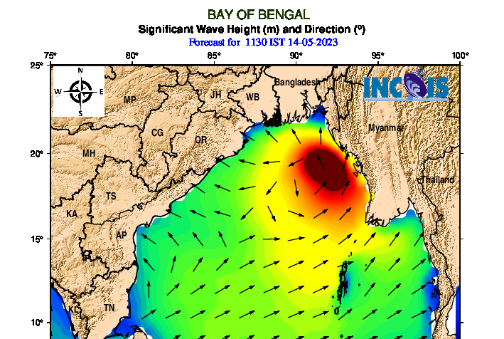
01B MOCHA 230514 0000 18.7N 91.8E IO 140 919
now hours away from landfall.
wtf
interesting
01B MOCHA 230514 0000 18.7N 91.6E IO 150 919
what the Fuck
@normal frost
POSITION: WITHIN 20 NM RADIUS OF POINT 4.8 S / 82.4 E
(FOUR    DECIMAL EIGHT   DEGREES SOUTH AND
EIGHTY TWO    DECIMAL FOUR   DEGREES EAST) AT 0600 UTC
MOVEMENT: WEST-SOUTH-WEST 11 KT```
inching closer and closer...

I just have no words
KEKW
i think some people have ilsa at 150
but officially hm
yea fani was the last one thats official
and not wpac
@normal frost

uhm
can we Not
Communication tower of #Sittwe fell down
#CycloneMocha #Rankine
jesus fuck
what the hell


uh oh
@normal frost hey dude
i wonder how the tropics are doing after mocha
surely we'll be getting a brea-

oh.
oh fuck no
death toll for mocha is now 5
o h

POSITION: WITHIN 20 NM RADIUS OF POINT 5.2 S / 79.4 E
(FIVE    DECIMAL TWO   DEGREES SOUTH AND
SEVENTY NINE    DECIMAL FOUR   DEGREES EAST) AT 0000 UTC
MOVEMENT: WEST-SOUTH-WEST 9 KT```55 kts 10-min
This morning, as sun shines over cyclone #Fabien, an eye can be seen. Rapid Intensification continues with slight VWS affecting the system, MW shows a small - pinhole eye that will continue to contract as intensification continues.


oh ho
bro this is swio
💀
G