#Meteorology
1 messages · Page 3 of 1


we're the first post to reach 2000 messages lol
You two were the hypercarry

our interest in tropical storm systems are unmatched
I've been talking to ap in dms about it since what 2021
checked
we started talking tropical storms may 16th 2021

💀💀💀
It's raining~

ho?
55*
also can i talk about FUCKING SMALL that is
frfr


haggis?
ITS BEEN 4 YEARS
its just date
so i assumed its hagibis
because i remember it lining up
yea it is hagibis
early october 2019
makes sense
ngl
i wouldve guessed faxai but it hit tokyo instead of there
or mirelle but i did remember it going into the sea of japan instead...?
yea

I'd like to speak to the BoM

KEKW
lets see if this activity sustains into april tho
shem peaks at march, and shit like fantala & monica happened in april
my guess is that it will end early
id hope not
i want an active aus for once
😭
shit hasnt been active since 2006
ironically the year monica happened
fr,,,
the thing is
mother nature hates me
so whatever i wish for
the opposite happens
💀💀💀💀💀
only need a bangkok landfall for that statement to be true
!!!!
now watch a wwb happen exactly in the gulf of thailand LOL
jk
dont think thats even a thing lol
but seriously tho
kinda jarring to compare the most active aus season to the least active one
fuckin
19 named storms...compared to 3
the latter of which happened only recently too, 2015-16
NOOOOO
im ngl idm having a tropical storm hit thailand
winter already dead and I WANT RAIN
💀💀💀💀💀
@normal frost @normal frost hdjjrmfmrmgmmfg
nmrmfndmfmmdmfmdmc

LOLLDKDMKFKFMRMGMMFMG
look at enala over there
LMAO
"I have unfinished business let me come back"
also the fact that freddy hit mozambique then proceeds to walk out of it too
thats my gift for ion
he does now
no LOL
ap,,,,
or at least i was supposed to
our president moved a public holiday from saturday to friday LOL
so gg
poggggg
poggers
bet
@normal frost uh
looks like we've got some interesting overrides

didnt even know that mfr does them
enala now TC
🤨🤨


what the fuck is happening with this storm LOL
5*
Making its final approach to #Mozambique, #Cyclone #Freddy is back at 60 knots of intensity which corresponds to a 30 knot increase over the last 24 hrs. As a result, #CycloneFreddy is now the only storm to achieve 5 separate rapid intensification cycles in the IBTrACS record.


oh right
first to do 5
after madagascar
ever
4!!!!!
its literally in the previews tweet to that LOL
😋😋😋

SH112023 (Freddy)
-Up to 06Z Feb.24-
Max Winds = 145kts
ACE = 70.0975
lfg
historic storm
70 ACE lets GOOOOOOOOOOOOOOOOO
94P red now
ye


Woi
ikr
atcf is back
11S FREDDY 230227 1200 21.1S 31.6E SHEM 25 1004
14S ENALA 230227 1200 28.9S 67.4E SHEM 40 1002
15P JUDY 230227 1200 13.5S 169.6E SHEM 45 996
96P INVEST 230227 1200 14.9S 149.3E SHEM 15 0
zamn
Today's visible images suggest #Cyclone #JUDY is strengthening—& nearing #hurricane strength. The beginnings of an eye are apparent. The cyclone's core should impact #Vanuatu's capital, Port Vila, tomorrow (Wednesday) morning. COMPLETE PREPARATIONS BEFORE DARK.
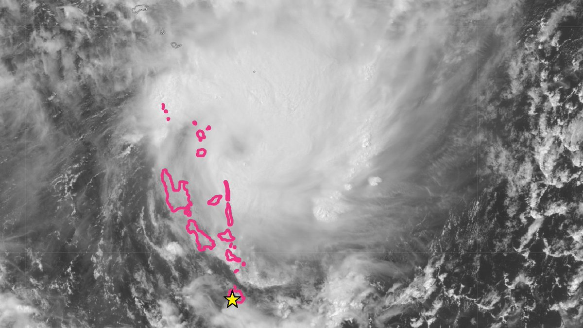

oh wow

In this video, we go over the 1999 Bridge Creek-Moore, Oklahoma F5 tornado - the tornado which produced the highest windspeeds ever recorded on planet earth.
Sources:
NWS Norman - https://www.weather.gov/oun/events-19990503
https://web.archive.org/web/20170211155104/http://www.weather.gov/oun/events-19990503-storma
good video
pls watch
TC ADVISORY
DTG:                 20230228/1200Z
TCAC:                NFFN
TC:                  JUDY?JU-DEE?
ADVISORY NR:         2023/7
OBS PSN:             28/1200Z S1548 E16818
CB:                  WI 160NM OF TC CENTRE TOP FL530
MOV:                 SSW 09KT
INTST CHANGE:        INTSF
C:                   970HPA
MAX WIND: 65KT```ye 10 min
LOL
they went 75kts i think
15P JUDY 230228 1200 15.5S 168.3E SHEM 75 971
here
thank

prayge
i mean this is purely spac so /shrug
😡
closing in on major status

wooooo
@normal frost
wait
According to our unofficial analysis, #Juliette has become the second #medicane of the year. More details soon, stay tuned. Find latest satellite imagery on our website: https://t.co/CqeAN2NrFy

wtf

LOL
@normal frost
Models continue to increase the strength of our East Pacific/West Hem MJO event, with the ECMWF especially showing a ridiculously high amplitude event. Should begin over the next few days.


?
and both were super ninos...
oh dear
🤨
16P KEVIN 230301 1800 13.7S 162.3E SHEM 40 993
KEVIN

kevin the fish killer
kevin!!!!!
yea until the vanuatu part
60 kts 10-min

jtwc forecast
probably


gfs:
it be like that
but >72 hours so I sleep

@atomic flint LMAO
imaginary hwrf storm
once again
wow every model has at least cat1 landfall
but it's like 190 hours so not reliable
by every model, only hwrf/hwrf-p, gfs, and ecmwf is available
💀💀💀💀
@normal frost so uh
ha?
o h .
yeah...
not fun at all
unrelated note why the fuck does my thai milk tea have so much fucking boba pearls


@normal frost

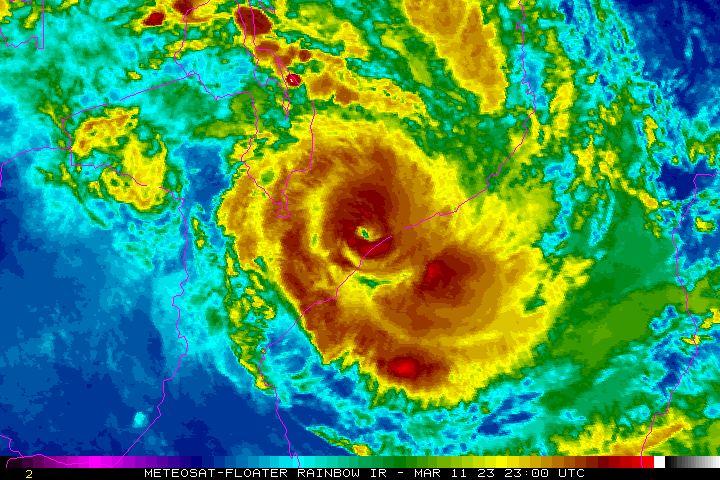
Port Vila at the moment. The second Category 3 Cyclone to hit this pretty city in 3 freaking days.
,,,,,,


Right he's making a scene again
16P KEVIN 230304 0600 22.3S 173.3E SHEM 135 918
ye
fms went 115 kts 10-min
or 130kts 1-min
but hey at least it made it to aus c5!!!!
💀
[Override]
16P KEVIN 230304 1200 23.3S 175.1E SHEM 120 936
16P KEVIN 230304 0600 22.1S 173.1E SHEM 130 923
16P KEVIN 230304 0000 20.8S 171.3E SHEM 140 915
16P KEVIN 230303 1800 19.6S 169.9E SHEM 125 930
@normal frost yo
AYO
I know this should be in #other-games but aint no way they made a stormchasing game in roblox
also istg if this motherfucker freddy outlive john
ik it became remnants and reformed but im counting it idc
wtf LOL
if u count remnants its gonna outlive it easily
if you don't, that's more interesting
It’s not something you see everyday when a southern hemisphere invest is in north hemisphere basin.

when the

wtf
nzms declared kevin as post tropical now gg
f

hmm?
💀💀💀💀
lmaooo
i cant believe im like
actually stormchasing in game
and taking pics
roblox ruined me
LOL
😭


Cyclone #Freddy is now tied with Hurricane John (1994) as the longest lasting tropical cyclone ever recorded.
Freddy still has many more days to go over the #Mozambique channel, and will likely surpass the 35-day mark.
This is truly a once in several decade event.
embed pls
yeeed
well if you count its time as a remnant low
@normal frost want something even funnier

OMG this is hilarious, The latest GFS has the remnants of #Cyclone #Freddy re-emerge back into the channel after its likely upcoming landfall in Mozambique, where they re-develop AGAIN. Would be absolutely rediculous if this verified (it likely won't) #tropicswx #LOCKITIN
💀💀💀
@normal frost @normal frost @normal frost

i look away for 4 hours.
and i come back to this shit
WHAT
mmmmmmmm
@normal frost
@proven rain
[Override]
11S FREDDY 230307 1200 23.0S 42.1E SHEM 85 970
11S FREDDY 230307 0600 23.4S 42.4E SHEM 70 979


Yeah, we were here when it made a history
indeed
https://media.discordapp.net/attachments/716216212207435806/1082639290489638942/Freddy_2023_path.png

this is a track of all time
Now where will he go
I dont think this is how tornadoes work

o h
11S FREDDY 230307 1800 22.8S 41.7E SHEM 95 959
@atomic flint
??????????????????????????
that's the 5th RI
from mr. freddy here

ow
A westerly wind burst is now underway in the eq. Pacific as the MJO arrives into the WHEM, the strongest event since at least March 2015.
This is causing rapid dissipation of La Niña and if a strong downwelling oceanic KW develops from this WWB, El Niño by fall becomes likely.


wow
wwb poge
@normal frost

oh come ON
that one ensemble that goes into madagascar at sub 970mb
LOL
@normal frost UHHHHHHHHHHHHHHHH

???????????????????????????????????????????/
when the Invest


why are half the fuckin storms so east

💀💀💀

UIASHFGTVIOSERNGIORSJHNFGV


certified Roblox
lmaoo


WHAT

mood

WHY

you already burnt one down????

you know
this would be an extremely cool and absolutely stupifying event
if uh
it wasnt stalling
over like
500k+ people or something

yeaaaa

As of 18Z, March 10, 2023, another record has been broken by Cyclone #Freddy.
Based on its 1-min sustained winds, the storm has the longest-lasting hurricane-equivalent winds worldwide with 18.25 days (and counting).
The old record is Hurricane/Typhoon Ioke (2006) – 16.00 days.
bro dapiya is still down
my ass got this pinned in a roblox server
added RAMMB and GOES because apparently I forgot
😭
É uma catástrofe. Não estavamos preparados para o #CicloneFreddy em #Quelimane.
yike.
seems to be making landfall right now
ow
#Freddy has come ashore again in Mozambique, near the city of Quelimane which was devastated by Idai in 2019. In doing so, the tenacious storm also broke Hurricane/Typhoon Ioke (2006)'s record for the most accumulated cyclone energy accrued by a single TC at an astounding 85.88!

yeaaaa

@normal frost agencies try not to ignore a storm challenge
bro this isnt even invested
impossible
wake UP aus
freddy show the show
LOL
so aus is now dead
CHICONY DT ABUSING AGAIN
JDNTMOGBNHMDKO,IBHNDT
WAIT THIS MAP LOL
@atomic flint yknow
I made a practice set for sheepy i think almost 2 years ago
on this map
yea LOL
, ,,,
NOOOOOOOO
ik lmao'
TXHONOLULU42 121130
TCSPAC2
SOUTH PACIFIC TROPICAL CYCLONE SUMMARY - FIXES
NWS CENTRAL PACIFIC HURRICANE CENTER HONOLULU HI
1129 UTC SUN MAR 12 2023
A. TROPICAL CYCLONE 11F
B. 12/1100Z
C. 18.2S
D. 173.8W
E. HIMAWARI-9
F. T2.5/2.5/D1.0/12 HRS
G. IR/EIR
H. REMARKS...CONVECTION WRAP OF 0.4 ON LOG10 SPRIAL YIELDS A DT
OF 2.5. PT IS 2.5. MET IS UNAVAILABLE. FT BASED ON DT.
I. ADDL POSITIONS
NONE.
$$
GIBBS
when cphc makes a good fix
joining imd in the group of agencies that suck inside their AoR but do fine outside
LOL
KEKW
too
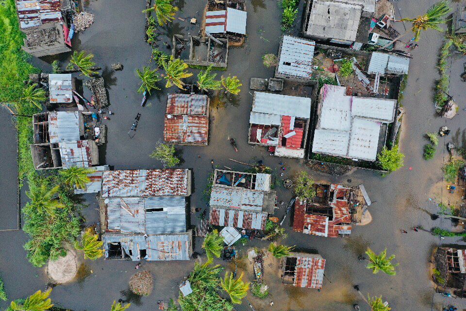
First drone shots emerging from #Quelimane show the enormous impact of #CycloneFreddy on homes, schools, and other infrastructure. Flooding is widespread within the city and surrounding areas.
@UNICEF is on the ground, responding, but additional support is urgently needed.


yikes


#LaNiña has ended, and the Pacific Ocean is now in a neutral phase – neither La Niña nor El Niño. The Bureau has issued an El Niño WATCH which means there's around a 50% chance El Niño will develop in 2023. Learn more: https://t.co/raJvaHEx6s
ooo
Reuters
Tropical Storm Freddy, one of the most powerful storms ever to hit the southern hemisphere, has killed 190 people in Malawi after ripping through southern Africa for the second time in a month, Malawi's disaster management agency said on Tuesday.
Jesus Fuck
yikes


Cyclone #Freddy (2023) is such an unusual, and a once-in-a-lifetime storm that we will never forget forever.
Here is the complete list of Freddy's all record-breaking milestones.
• the longest-lasting TC worldwide (lifetime) – 37 days
• the highest ACE worldwide – 87.01 [1/5]
jesus Fucking CHrist
Another view of the Australian BoM ENSO model showing a super El Niño by August. Our best possible future is one where this is completely and totally wrong.

hey Uh
...can we not?
oh dear
i want an el nino
the pacific would be 🔥 for trackers
tho w/o the deaths please
...but a super el nino is Yikes.
im gonna die

yea 💀
freddy is dead

that just makes it worse
it was already really bad before the 200 deaths
are we gonna talk about this mf 91p
KEK
And in just a matter of weeks, La Niña practically disappeared from the Equatorial Pacific, with very warm waters. One of the fastest transitions to a warm neutrality/El Niño that I've ever seen.

o/
you won't be missed

Before and after satellite image of #Freddy's second #Mozambique landfall. Some of those rivers are more than 5 miles wide now and are essentially lakes. #Quelimane appears to either be completely under water or an island.
jesus fuckin christ
holy shit
?????????
yeah thats...not fun at all

💀


we have TD 09


yay

lets see
not much time left tbh
probs c3 aus at most

slightly interesting
94S
jtwc went 35kts but didnt upgrade it


sheared slop perhaps?
KEKW
also this had like 40 kts support apparently?
yikes
freddy alone will be 90% of the season's ace LOL
u mean freddy + darian
both combined make up like 130 ace?
darian who
id wager its pretty Damn Hard to beat that
hey cmon
darian reached 42 ace!!!!
thats pretty Big!!!!!


@normal frost truly the most 60 kts storm of all time
(jtwc went 60 kts)
(tho tbf they're doing an exercise rn so repackaging shit from BoM)
(BoM went 55kts 10-min which is ????????)
???

holy fuck ok
me in sea
🔥🔥🔥🔥🔥🥵🥵🥵🥵🔥🔥🔥🔥
now give us a freddy 2
when the heat index
in april????????????
actually there's a gunga consistent signal that might turn out to be a major sooner or later
been there for a week now i think?
but its nowhere near a freddy lol
what the hail 32°c on new guinea and North Australia?!!!!!!
ill take it
yea those are sea surface temperatures
26.5°C and above = good for tropical cyclones
||there's other factors too but shush not relevant rn||
now 30 on the other hand
💀
Yeah, just searched it
m.
its just hot
my brain
also that part of the basin has pretty huge history for RI shit
i see yall say yolanda and i need a second before i know what it is
like extreme RI shit
ernie, veronica, etc
yolanda is cooler ngl
hone 2023
im just waiting for the 2023 super typhoon in October or November
hopefully not a hit
we shouldve gotten it a long time ago!!!!!
like 4 missed tcs already LOL
Annual dose of super typhoon
TRUE
in el ninos you don't have to wait til then
could get one as early as next month really
4/20
they usually dont hit land tho
also hey finally someone other than ap and jherold talking here LOL
💀
KEKW
usually
kek
i dont think april super typhoons have hit the Philippines
gotta get someone to check that tho cuz idk
lmao
Oh god not Glenda

aw hell na
yikes.
the name rammasun itself isnt even from thailand
i remember even moa got damages from that beast lmfao
o h
I remember answering my math division sheet that time lol
💀
While it's all chaos outside
chad filipino dismissing typhoons
just your normal filipino day fr
i mean i went to the arcade on the night that noru hit
mfers closed early tho LOL
only got to play for less than an hour
💀


nice eye
still 60,,,,,
Ayo
knots is standard in meteorology actually

just refer to this
also
WMO's Hurricane Committee retires Fiona and Ian from the list of rotating names because of the death and destruction they caused in 2022.
They will be replaced by Farrah and Idris in 2028.
🔗https://t.co/t9e9bteysp
Likes
948
Retweets
560

yea i saw
ngl i thought julia would be gone too
now watch idris get retired lmfao
lol
i-name curse
We need very intense tropical cyclone Bonnie for the funny
the day hermine gets retired the world will end
60 = 111kmh i see
that name is there for SO LONG
i get it now
KEKW
bro didnt even leave africa
actually so dumb
After Freddy, this will be the perfect scenario
ok now another cat5 will hit the us this year
💀
TRUE
depends on how strong the nino is
tho c5 monsters mostly do happen in inactive years so /shrug
there were only 2 c5s in 2017 right
💀
kekw
meanwhile 2005
💀
4 fucking c5s
3 of em in the top 10 basin-wide
literally How
rofl
its a c4 so
still
Yeah that one was yikes.
natl decided they wanted to be wpac that year
💀
honestly the weirdest part about 2005 for me is that
most of the storms there were actually strong
unlike the 2020 slopfest incident™
we do NOT talk about 2020
the only reason 2020 wasnt a slopfest is cuz oct/nov carried HARD
yeah
also first half of the season makes me want to kill myself


LOL
LOL SAME BRAIN CELL
JKISROEFOVSMFVOISMFIOSMFS
we both share the same braincell it seems
💀💀💀💀💀
that crop is almost the same too LOL
yeah lmfaooo
oh shit
A. TROPICAL CYCLONE 17S (HERMAN)

B. 30/1130Z

C. 15.64S

D. 105.41E

E. FIVE/GK2A

F. T5.0/5.0/D2.0/24HRS  STT: S0.0/03HRS

G. IR/EIR

H. REMARKS: 46A/PBO EMBD CNTR/ANMTN. LLCC EMBEDDED IN W YIELDS A DT
OF 5.0. MET/PT YIELD 4.0. DBO DT.

I. ADDITIONAL POSITIONS:
   30/0650Z  15.42S  104.87E  ATMS
   30/0652Z  15.40S  104.72E  AMS2
   30/0652Z  15.42S  104.83E  AMS2


PETERSEN```T5.0
tho they also went T5.0 in 6z
took long enough
KEK
oh my fucking god
and uh.

On Thursday, police said those missing would be presumed dead upon completion of rescue operations, which were still ongoing in some areas.
sadge
,,,,,,,,,,,,,,,

my sincerest condolences


maybe

oh my Stupid Ass Bitch @normal frost
BoM maintained
.
17S HERMAN 230330 1200 15.7S 105.4E SHEM 90 976
jtwc took matters into its own hands LOL

lol

just look at top right
nice intensity you got there jtwc/bom
LMAO
ok bom woke up a bit
high confidence in the position. An eye pattern yields a DT of 4.5 at 12Z.
MET/PAT is 4.5 based on a D+ trend. FT/CI is set to 4.5.

Objective guidance (all 1-minute mean): SATCON 64kt at 0647Z, CIMSS ADT 72kt at
1200Z, NESDIS ADT 61kt at 1210Z, AiDT 66kt at 1200Z, CIMMS DMN 48kt at 10Z,
CIMMS OPEN-AIR 67kt at 12Z. There was a jump in intensity in objective guidance
since the 1200 UTC analysis was first performed, along with the appearance of
an eye in EIR imagery, so the forecast has been updated.

Intensity set at 70 knots (10-minute mean) based on Dvorak analysis,
development trends and objective guidance. ```yay

@normal frost i woke up to a c4 aus
epic
goddamn this storm is on crack
hey it didnt want us to be too bored

yummy eye

