
#Weather and geological phenomena
1 messages · Page 2 of 1

Image I actually sent to the NWS just now 😵💫
Two geolocation requests sent by a storm chaser!

FOR MEDIA INQUIRIES OR ANY DONATIONS TO RECOVERY EFFORTS PLEASE CONTACT:
PAYPAL: [email protected]
VENMO: @Alexander-Scholten
On the evening of June 22nd 2024, a supercell thunderstorm produced a tornado just southwest of Janesville, WI that tracked through my neighborhood and produced significant damage to trees ...
At least 7 tornadoes tore through southern Wisconsin on Saturday, June 22. The communities of Argyle and Janesville were hardest it. This video documents my chase that day.
Very proud how these turned out.
weather adjacent but interesting AF

Augmented reality sandbox, the 3D interactive tool to decode mapping and topography
Always fun seeing those things around!
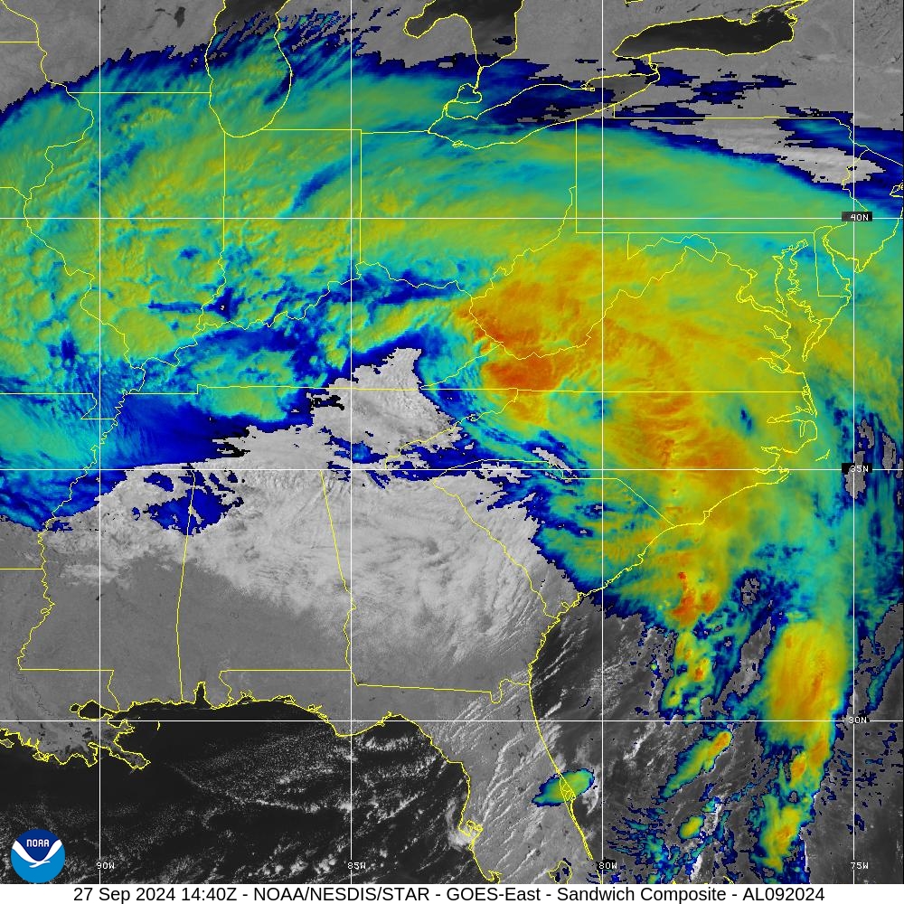
Hurricane #Beryl Advisory 13A: Noaa Hurricane Hunters Find Beryl Even Stronger as it Moves Quickly Across the Southeastern Caribbean. Hurricane Warning Issued For Jamaica. https://t.co/tW4KeGe9uJ
A potential CAT 5 in July is... historic for this area,
(2MPH away from the strict classification for the rating- from the recon trips.)
Anybody here use windy pro? Do you think it's worth it?

Its not supposed to happen so damn soon in the year
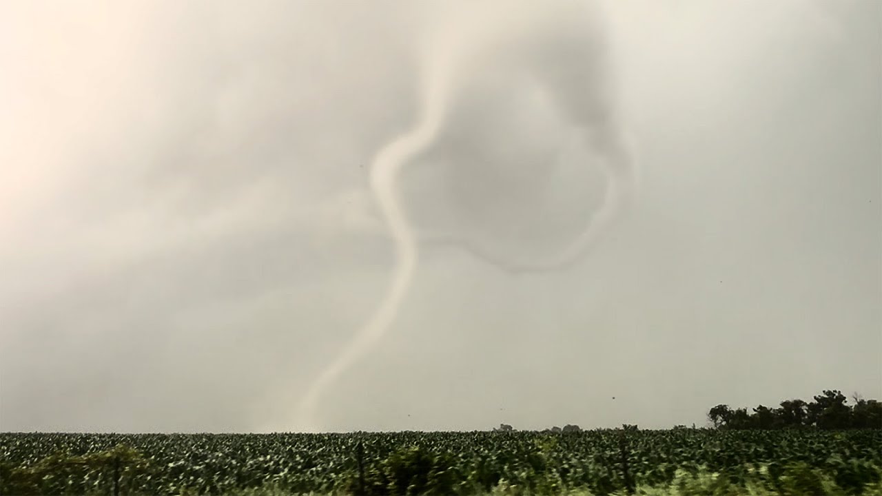
Surreal urban tornado touchdown in #Dongming county, #Shandong province of #China, around 3pm local time on 5 July, 2024.


industrial and residential area took a hard hit in Dongming, Shandong Province.... hundreds of injuries, maybe some fatalities, so sad to see all of this.

WHOA!
Two waterspouts are over the lake right now near the Twin Span in Slidell!
Source: Ehryel Wade
WHOA!
Two waterspouts are over the lake right now near the Twin Span in Slidell!
Source: Ehryel Wade

Extreme close range of the powerful tornado in Dongming, Shandong Province. The photograher likely recorded the moment tor struck industrial park and obliterated it.
starting geolocation attempt for this area.
35°19'50"N 115°11'33"E a good candidate?
I got a lead that it may be closer to Heze, (Unverified- might be one of the 3 areas hit, and not specifically where the image is.)
My specific "what i'm looking for" notes,

That red roofed building across the street with the large parking lot is probably what'll tie the geolocation together.
Also- unfortunately looks to be of a different area
We're also on the edge of residental vs industrial,
I also have my suspicions that this video is at the same area
Agreed. They look separate.
Also to add into confusion- there were atleast 2 tornados in this province.
(Potentially up to 5!)
So trying to geolocate additional tornado footage may not fully help.

GeoConfirmed World.
A major tornado in the town of Dongming in Shandong province.
8496+WG2 Dongming County, Heze, Shandong, China
35.319763, 115.111268
GeoLocated by @Asia_Intel
Geolocation: https://x.com/Asia_Intel/status/1809147771296862235
Location: https://geoconfirmed.org/world/021fc356-f04a-447b-c791-08dc9c60acd9
Sources: https://x.c...
Different footage geolocated (Notably CLOSE to where your coords were!)
Resorting to finding more data from original source- Went to Douyin.
Welp that went into the shadowrealm.
Not gonna mess with Automod- if you wanna look at the source vid- Go to Douyin and type in those numbers seen at the bottom right.
probably near a gas station that's labled as "Sinopec"

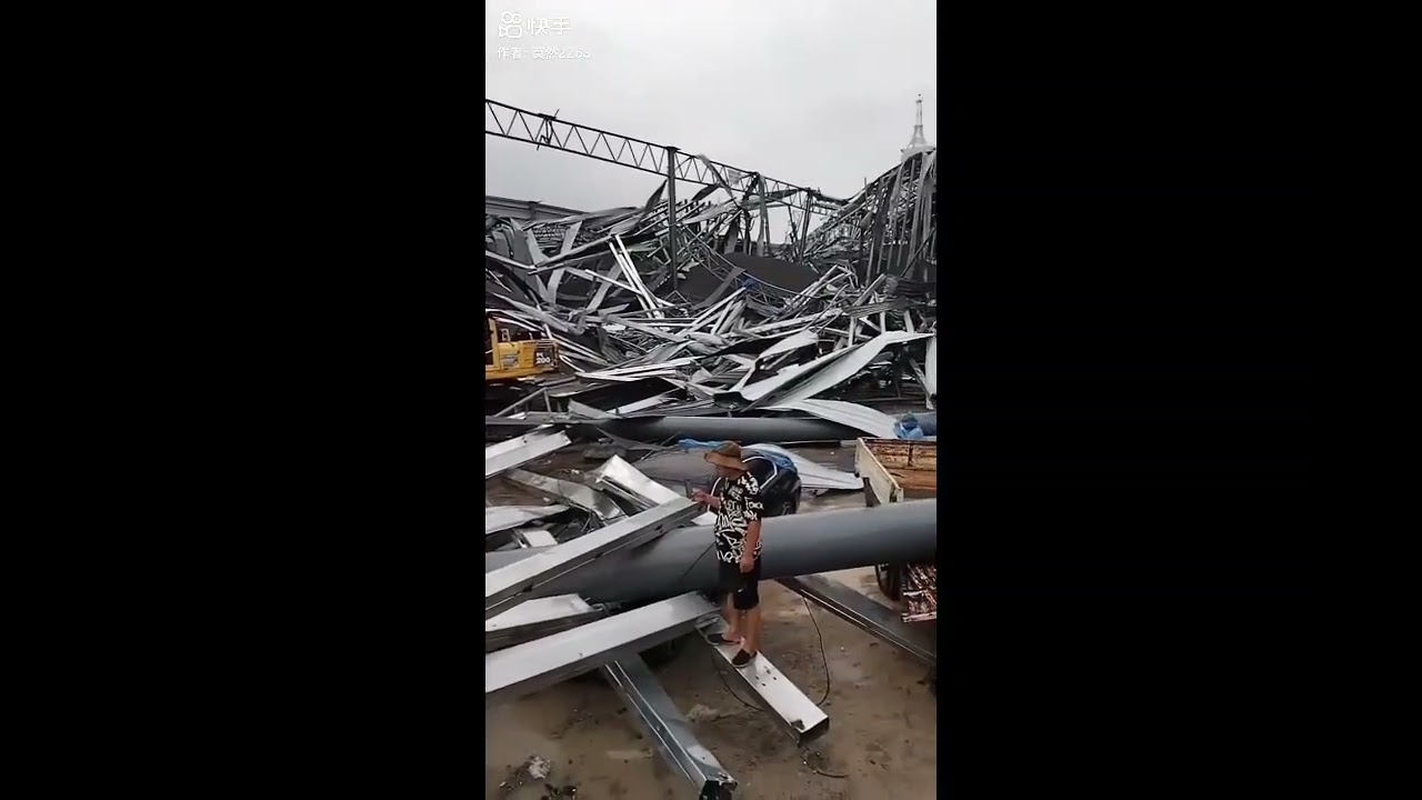
The violent Dongming tornado hit a cement mixing plant near peak intensity, almost completely demolished the whole site, some heavy tank loaded with cement were tossed.

Damage points we're able to find thru internet and radar data so far, time were plotted on the track use radar data, a cluster of 8-9 tors in just a small region were evident, and we're still counting.
Yes i am currently attempting to reach out to see if the concrete plant has been geolocated (mainly so I don't "double work" a solved area.)
Still feeling good about my location of the first video. Looks like it's on the red path.
Strange weather today in Texas: there’s these things called “clouds” in the sky? (This is a joke comment, I’m actually relieved that there’s clouds)
Damn shame it’s preceding a storm though
The first video?
If you're talking about the apartment complex vid- that was 4 miles to the SW,
Ah, the first I did. #1204206076493434930 message
Yeah this is the same concrete plant.
White and blue silos,


Recorder was in a crane or something similar (forklift/ tractor?)
In fact, when that "outer shell" collapses- it reveals an interior that is close to what other industrial concrete mixers in China look like


Well,
This would have made my life easier.
Yeah Louisiana is getting rocked
Pleasant Hill may have been hit just now

That one is quite strong

Both of these are quite strong


Goddamn

We've got the remnants of hitting us here in Southern Ontario tomorrow
Got a rainfall and wind warning in effect in Toronto


Strong tornado in KY again.
PDS issued

STRONG TORJARO MADISONVILLE #kywx @NWSPaducah
How close it got to town

Debris spike.


Uniontown, however likely was hit to some degree


The Town of Eden is under a State of Emergency. Significant damage has been incurred at a number of farms, especially barns which are a total loss, and animals are injured. Thankfully there are no reports of human injuries.


I'm not a weather expert... but this sure looks like a tornado forming over @CityofLdnOnt.
Filmed moments ago from West 5 / Riverbend area.
@CTVLondon @LFPress

@dwhart @CityofLdnOnt @CTVLondon @LFPress Geolocated to around (42°57'59"N 81°21'42"W) looking NE.

Check this out - corn crops have become sprouting along the damage path less than 2 months after a strong tornado impacted the city of Greenfield, Iowa. #iawx #greenfield #wx #tornado
Photos belong to Wendi Rae on Facebook, I could not find an account on Twitter to link to it. The original post linked below.

Very rough path estimation- assuming the higher degree of damage to be on the right side of the core winds (from tornado's perspective)

This is an Alberta Emergency Alert. Environment Canada has issued a tornado watch alert .
This alert is in effect for all communities between Wetaskiwin and Calgary, that are west of Veteran's Memorial Highway 36 and east of the foothills (see detailed map in link).
Conditions


#meteoqc #qcstorm tornade #brossard 2024-07-24 20h11

Fire tornado in progress, #ParkFire
Might have been one of the strongest fire tornados of recent history. That one fuckin went for it
Bizarrely, since was a case of arson (someone set fire to a car),
This is one of the first verifiable "man made tornados" occuring in a way.
...don't let the crazies hear that one tho.


FOX Weather
The American Meteor Society received around 140 reports of people both seeing and hearing the event. NASA said its analysis found the fireball traveled from west to east over Tennessee before breaking up over the Tar Heel State.
A PDS Red Flag Warning is in effect Wednesday from 11 AM to 8 PM for the Sierra Front including the #DavisFire. This is a PARTICULARLY DANGEROUS SITUATION. Gusty winds & dry conditions will lead to very rapid fire growth. #nvwx

Looking at the current location the #DavisFire is burning on a mountain, immediately downstream of tomorrow's winds is a neighborhood with homes built in the midst of quite a bit of ground fuel & trees. Won't be able to stop ember attacks. Great warning that will save lives.


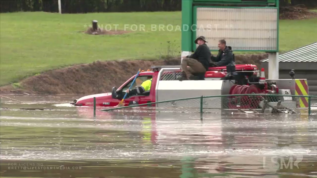
Yeah we need a Flash Flood Emergency in the New Orleans metro


EXTREMELY DANGEROUS FLOODING: A rescue is underway at the Canal Street Underpass after a person drove a truck around the barricades and into the flood water. We cannot stress this enough. STAY OFF THE ROADS
Driver was rescued about 10-15 minutes after this clip ends.

INCREDIBLE RESCUE: With just seconds to spare, a Good Samaritan rescued a man who drove into flood waters at the Canal Underpass, saving his life.
2025 could be 2011 all over again with the warm NPO also persisting through spring
👀
Reed Timmer is one of the go to guys in the field- if you've seen storm chasing documentaries/TV shows (Especially back in 2011-2013)- That was likely Reed Timmer.
you can spot 2011 pretty easily on this graph

Oh boi

Large wedge tor right now! Possible major damage in Sihong, Jiangsu Province!
Every time i see tornados, theres a small part that says "This gots be CGI"
at a certain point, weather looks fundamentally fake
🥹

oh hell yea! best of luck and have fun
If I had a nickel for every youtuber named Will that I researched for-
I'd have two nickels, which isn't a lot but it's weird it's happened twice
casual <2% day

2nd tornado hit Portland, Indiana.

Damage pics so far show houses missing roofs, trees that got absolutely munched, I'd estimate a suprisingly strong tornado rolled through the area- but likely wouldn't be lethal
(Not sharing as the home's address is plastered on the side of the building- not risking it. It's on Twitter.)
Dang. Hope everyone made it out unharmed
This image I can share- looking at the HS
https://x.com/INILKYWeather/status/1838017086498455600

my assessment of the damage pics (Camera is orientated North), geolocated to 40°25'46.01"N 85° 1'15.17"W

That "Unknown object" (as seen in the above screenshot- that box could be the school's HVAC system, maybe. Very hard to tell.
That would be DOD 5 here (EXP of 101 MPH, although could range between 85-119 MPH. further review needed. but likely is on the lower end of that scale.)

That house has a large overhang on the right side (Heading of 295 degrees/ NW)- Likely a point of failure as the wind got under it and levered that entire section of roof up and off the building.
Likely will be rated less than what would be typical.
(literally if the house was on the other side of the street/ didn't have that porch, likely would have much less damage.)

More damage to Jay County High School and the area around it just outside of Portland @NWSIndianapolis #inwx
(More damage pics around the HS)- looks like decent roof damage [also under DOD5], tree damage would likely be DOD 4 here. (I'm not a tree dude so I can't tell if this would be TH or TS.)


If all DI's are EXP- most of these are agreeing with around 100-110 MPH range at first glance Please refer to the NWS report when it is (eventually) finished.
Found additional (closer) pictures- Likely part of the school's HVAC system.
https://x.com/CalebIvins1/status/1838027909820276778


We are tracking Potential Tropical Cyclone #9, which is likely to strengthen this week as the system enters the Gulf of Mexico. I have issued Executive Order 24-208, declaring a state of emergency in 41 counties in Florida that could see potential impacts from the storm and
lol, lmao even- First preliminary has the trees at 100 MPH, HS at 110 MPH.


green line is the estimated centerpoint for the preliminary rating,
Green triangles indicate an EF1 DI,
the pins are my notes from here

Right mover on the KY/TN state line!

that storm takes a hard eastern shift and immediately starts showin promise,
Violent tornado SE of LaGrange. Significant damage to several homes and multiple serious injuries. Search and rescue performed and emergency crews are on scene @NWSIWX #inwx
Latest wording from @NWSTallahassee is as serious as it gets. "There is a danger of catastrophic and potentially unsurvivable storm surge for Apalachee Bay." "...nightmare surge scenario for Apalachee
Bay." 😬 #flwx #Helene


Might see some flood damage as far north as Atlanta, GA honestly- they're getting rained on quite a bit today as a bit of an appetizer.
Storm surge potentially up to 20 FT

Hope everyone makes it through
btw here's all of the warnings that are already issued.

Most of FL, All of GA and SC under some level of warning.
godspeed, everyone
this is a model run for GA lmao

955mb is a pretty mid analog for a Cat 3 lmaooo this is so not happening.
Oof! I'm about to get hammered.
I wonder which one of the trees in my yard are going to try to occupy my house.
Good luck Snap
Thanks! I might need it.
Stay safe, aight?
Hopefully, we will make it through the storm unscathed. I also have concerns about our office; there are giant trees next to it as well. If the power goes out, we’ve got plenty of dry goods, canned goods, gallons of water, cat food, beer, wine, and most importantly books that need reading.
If you’re interested in urban exploration, for a book for you
If it isn't already on our shelves, it might be too late.
Yea, figured. Consider it as “something for the undetermined future”
Undetermined future describes my life lately. Keeping with the theme here, Access all areas should be revised to include "in all weather conditions".
Fair play, and glad you know of that book!
bet. I'm hip, kind of.
Worth a read since it delves into the mental state of people who willingly venture into (sometimes) abandoned structures
and it might as well be a fucking autobiography of my mental state too while exploring lol
I know that we are getting a bit off topic, but my colleges and I have to explore urban places as a day job. Some times it's fun, but other times we get threatened by the local inhabitants and get run off.
There’s low pressure in the Midwest and high pressure along the eastern seaboard, steering Helene through the path of least resistance right over us.
Helene Helene Helene Heleeene. I’m begging of you please don’t take my house. Helene Helene Helene Heleeene. Please don’t take it just because you can.
Dolly Parton anyone?
Personally do not understand the reference but hope someone here does
Look up Jolene.
It references a song... Ill listen to it
huh. Cool song! Now i better understand that reference
Who would have ever predicted that Dolly would be mentioned here. Btw, I think she might be in the path of this as well.

Tornado on ground southwest of Bluffton, SC
Hurricane Helene officially marked as a Cat 3 hurricane as of now. (Classifying it as a major hurricane.)
Still has room to intensify.


wowzers
That doesn't seem wise...
current flood forecast for Biltmore Village (S of Asheville, NC)

May i ask program is this?
gauge photos from the site

iprobably the site you want
circle= Observed flood state (color indicates severity- Yellow-Orange-Red-Purple)
Square- max flood forecast (same scale)

...fuckin lmao- 30.5FT flood in the forecast at this spot in NC, personally- probably shouldn't happen.

Naples FL is the first station to record a locally major flood at 3.6FT

10:00 EST flood gaugue update-
3 recording local major floods (14 forecasted)
Naples, FL -3.97 FT [No previous record on file]
Alafia River (close to Tampa, FL)- 6.35FT (Forecasted- 7.90 FT)[Site Record of 6.60FT]
Peachtree Creek (NE of Atlanta, GA)- 18.06 FT [Site record of 18.60 FT]
Luckily the center of this storm is coming ashore where it’s mostly wildlife management areas and state park lands. The population density is low right on the coastline here. As it moves inland, that’s a different story.
Here's a live stream from some guys sitting in a Toyota RAV4 on Cedar Key. https://www.youtube.com/watch?v=pxTqQss2dvc&ab_channel=WXChasing

Driving around Cedar Key, Florida in Hurricane Helene
Cash App: $wxchasing
Venmo: venmo.com/bclemms
Check out Jonathan’s youtube channel here YouTube.com/jonathanpetramala
Please subscribe and click the notification button so you know when we are going live!
Looks like the one NE of Atlanta is finally starting to crest out at 18.25 FT

It's been raining where I live in GA almost nonstop for the past 36 hrs.
All of GA's current flood gauges (I have OBS/ Forecast "No flood" and other error codes turned off to make the map less cluttered.)


Street View · Google Maps
Explore a place in a more immersive way in Google Maps.


11:10 EST flood update (a lil late, sorry)
5 stations recording a major flood (14 forecasted)
(Not counting 2 in ND that are in "Major flood" at 0.3 ft.)
FORMAT: Station[MAJOR:FT requirement]- Observed reading [Previous Record] Climbing/Crested/Decreasing
Naples, FL[M:3.5 FT]- 4.02FT [No record on file] Crested
Alafia River (E Tampa FL)[M:5.7FT]- 8.24 FT [6.6 FT] Climbing
Clearwater Beach FL[M:6.0FT]- 6.62 FT [4.0 FT] Crested?
Cedar Key FL[M6.2FT]- 7.60 FT [6.8 FT] Climbing
**Peachtree Creek **(NE Atlanta GA)[M:17.0FT]- 18.42 FT [18.6 FT] Crested
*Updated to include FT required to meet "Major" flood requirement per station.
i quite like this format tbh
Each category's description
ignore the heights tagged here- specific to this station,


Quitman and Valdosta are going to have a rough time. Thomasville too.
..wha..

This live stream is kind of stressful. 😬 #1204206076493434930 message
Went from -1.31 FT to a 9.63 FT flood in 1 hour.
real rapid flooding.
12:20 flood station update- 10 marked as observing a major flood, 15 forecasted to.
7 of those OBS's are in FL
2 in Atlanta, GA.
1 in NC
My yard is 100 percent flooded.
Station[MAJOR:heightrequirement]- Observed reading, [Previous Record] Climbing/Crested/Decreasing
All readings will be in FT.
Fort Myers, FL [5.0]- 5.07, [7.3], Crested(?)
ST Petersburg, FL [6.0]-6.20, [N/A], Rising
Old Port Tampa, FL [6.0]- 6.63, [N/A], Rising
Alafia River (Riverview, FL)[5.7]- 8.98, [6.6] Crested(?)
Cedar Key, FL[6.2]-8.65, [6.8], Rising(? Might be near crest)
Steinhatchee, FL[6.0]- 9.63 [8.0], RISING
Peachtree Creek, Atlanta, GA [20.0]- 20.06 [25.8] Rising
Peachtree Creek, Atlanta GA 2 [17.0]- 17.74 [18.6] Decreasing
Nancy Creek, Atlanta GA [13.0]- 13.19 [15.5] Rising (near crest.)
Wilson Creek, Collettsville NC [12]- 13.20 [N/A] Rising
take the second number minus the first [number] to get the "excess flooding past scale" per site.
Preliminary data from a drone that the National Weather Service launched into #Helene shows a 158 mph winds, which would be category five status. This data will be used in the coming months for a post-review into determining the landfall strength of Helene. #FLwx

Flash Flood Emergency including Atlanta GA, Hartsfield-Jackson Atlanta Airport GA and East Point GA until 1:00 PM EDT

Power's out here
And also new life goal, gonna sleep in every natural disaster atleast once.
So far I have slept through
Tornado zero meter (2018) wildfires (multiple times) earthquake (M.2.7, 2021)
On the porch atm,
Stay safe m8
My setup is sooo fuckin jank lmao
How jank?
Two lawn chairs, bungee cords, a freezer, and some cardboard jank
Freezer is my anchor in case it gets insanely bad lol

Any wind?
Like 10-15 MPH gusts so far, center is still over TN
Stay safe, dont be a dumb about it
...#HELENE PRODUCING HISTORIC AND CATASTROPHIC FLOODING OVER PORTIONS OF THE SOUTHEAST AND SOUTHERN APPALACHIANS...
...FLASH FLOOD EMERGENCIES IN EFFECT FOR METROPOLITAN ATLANTA, AND MUCH OF UPSTATE SOUTH CAROLINA AND WESTERN NORTH CAROLINA...
eep went great- only slightly damp
unfortunately power came back on (turned on the lamp over my head) and I had to go back inside and continue working 😭
(See attached for sleeping setup- Bungee cord was added post image when I realized that cardboard doesn't want to stay there.)

A good chunk of the Appalachians are currently flooding

Some to record amounts
Also hey don't shaking eye react me I've done much worse 😠
so i was gonna do the ol flooding format... there's 32 of them 💀
i'll pass along the "highlights"

eaten by the filter- refer to https://water.noaa.gov/
Glad to know that you and those you hold close are alright for th emost part
btw all of the graphics for Hurricane Helene for it's entire life if you wanna see the warning evolution
I-40 at the North Carolina /Tennessee border is washed out. #cltwx #ncwx #wncwx #tnwx

well damn

@wxbrad Pretty sure this is the spot, ( 35°45'27.18"N, 83° 3'3.51"W) looking W/SW
holy smokes yeah
at first I thought "No no that's not it, you're looking for a two-lane highway going both dir... oh man!"
reasoned that the road was an S turn curve* hugging the river- mountain's on the right, so that narrowed stuff down pretty quickly, then was looking for the matching mountain backdrop+ the rock fence
27 minute geolocation 🫡
Thought the same too at first. Erosion is WILD to witness
Some of this damage is even more jarring from up above. These images are from Tiffany Boulevard in Rocky Mount just hours after a tornado touched down there. Photos are from Hunter Lilley. @WRAL


@heididkirk @WRAL Located to (35°58'32"N 77°47'59"W)-
This is the 2nd time Rocky Mount, NC has been hit by a tornado in the past 2 years.
lol, lmao even- what the fuck is being circled on half of these

(Also argued on my verification post that "nuh uh it's AI" when i... provided the exact area the photo was taken from)
wtf is bro on about?
Rule #1 of X is ignore eveyone else on X
I went to have a look and they'd deleted most of it. 🙁

‼️‼️
MASSIVE FLOODING IN EASTERN TENNESSEE
This is likely either Newport [ https://water.noaa.gov/gauges/NEPT1 ] or Embreeville TN [https://water.noaa.gov/gauges/EMBT1 ].
Leaning towards the Embreeville area. Went from minor flood (10.01ft) at 6:15 to the gauge going offline (likely overtaken by water at 19.56 ft) at 11:15


(Found some sources saying Elizabethtown, TN [https://water.noaa.gov/gauges/EZBT1 ]- which is a fair bit NE of Embreeville)

Also yes each time scale is different here because there is no consistency between gauges it is irritating
trust me it was dumb all the way down.


UPDATE: More than 50 individuals have been safely evacuated from the Unicoi County Hospital.
This video is from a TEMA District Coordinator who responded to the initial evacuation request Friday morning.
This will unfortunately likely be a very high death toll for a lot of these communities along the mountains.
Seen it before year after year.
https://fxtwitter.com/forecaster25/status/1839781822147817885
Chimney Rock, NC.


When you’re in a path of a hurricane, wtf can you realistically do except for “GTFO or hunker hard”?

I can't comprehend what has happened in western North Carolina.
This is Asheville.
National Weather Service has said this is one of the region's most significant weather events of the modern era.

Do not travel to the mountains.
... there's a lot of bodies in the valleys.
A lot of missing person's posts in these areas too, this death toll will rise. (Currently at 49)
And as always, if (you’re) sensitive to this, do not look for any potential images
As of this morning, over 400 roads remain closed in NC. All roads in Western NC should be considered closed.
Remember: As crews work to clear and inspect roads and bridges, please give them room.
Go to https://t.co/AGDVnBcrXk for the latest road information.

^just for NC.
It is still raining in the area occasionally- Some of the rivers are still flooded.
Geolocating the images sent just before people died is the biggest heartbreak.
NOT FOR BROADCAST
Contact Brett Adair with Live Storms Media to license.
[email protected]
A rescue of an emergency vehicle with crew happened in the City of Harford, TN on Friday. Crews were standing on top of their truck until help arrived. The Pigeon River was raging causing major flooding with water rescues going on all over ...
tamer area in TN
context of the water's power. Gun safe washed down river.

Geolocated to around ( 35°26'24.80"N, 82°14'58.27"W)


look at all of that silt that got moved up here


Weather is a scary thing, and to NEVER be underestimated
censored to not even risk breaking Discord TOS- but this is the gist with a lot of the missing persons posts

i'm currently at 57 recorded across FL, GA, SC, NC, TN. First news reports of 100 unnacounted for in GA alone.
A lot of these people are hopefully safe, just stranded in an insanely rural area- the Appalachians are not the nicest sometimes, so it is vital to get a tally on how many are missing, and where they were last seen going
Death toll has increased to 50 people so far.
https://www.cnn.com/2024/09/28/weather/hurricane-helene-florida-georgia-carolinas/index.html
🚨 REMINDER: 𝘼𝙇𝙇 𝙍𝙊𝘼𝘿𝙎 in Western North Carolina should be considered 𝘾𝙇𝙊𝙎𝙀𝘿.
I-40 and I-26 are impassable in multiple locations.
⚠️ Travel in this area for non-emergency purposes is hindering needed emergency response.
#ncwx #Helene

Higher quality version of the same area.
So much for that one person claiming AI
may have DM'ed them another verification post using the higher qual version 👉 👈
“UwU may I have some more pics please?” lol
Smart move on your end

^Just one area.
There's one road in and out of Asheville that's not washed out (that I can find proof of.). If they were fully stranded (air only rescue) you'd be looking at Katrina x 10.

# of missing person's suddenly started decreasing- did some digging, found this.
I am however personally able to confirm atleast 4 fatalities in North Carolina (Next of kin posts.)- potentially a 5th* in Chimney Rock. There are no official numbers for the state yet.
*Additional update to add an additional fatality.

It looks like there may be a tarp or something over the front of the car, which is why i'm leaning towards this being a fatality. Absolutely wild how these mountains funnel the water into insanely violent currents. Image is from https://www.facebook.com/share/p/zhYbKPTsXE6v1ax4/
DISTANCE SHOT OF A CRUSHED CAR- POSSIBLE BODY WITHIN CAR.

Likely a mix of double counting missing persons (due to there being multiple forms/ phone numbers to report missing persons) and people who are safe, and are just now getting (very limited) cell service. Hopefully their phones aren't waterlogged or otherwise dead.


CAP images from Asheville NC catastrophic flooding.
Image #1 (35°34'18.00"N, 82°31'52.00"W)
Image #2 ( 35°34'7.83"N, 82°32'39.74"W)
Image #3(35°34'9.00"N, 82°33'42.00"W)
Image #4 (35°33'57.00"N, 82°32'30.00"W


i just woke up ☕,
I also run "weather channels" in a couple of other discords so a lot of info is "categorized" per group's interest-
This one gets more "geolocation"-type posts because I feel like y'all would like it more
Certainly not gonna complain about geolocation!
Hell, we like it when people talk about nerd shit. The passion they have is infectious

NOT FOR BROADCAST
Contact Brett Adair with Live Storms Media to license.
[email protected]
One of the first videos to be on the ground the moment water receded in Biltmore Village in Asheville, NC on the afternoon of 9-29-24. Devastation to many buildings along the river. Parts of buildings became river debris following historic r...
Not a good day when one of these videos goes viral.
Live Storms Media is the place chasers send their footage in to license it so news orgs can buy it.
Media aggregator.


I’ve never been more thankful to be an iPhone user.
Due to the lack of cell service, EVERYONE in Asheville NC right now on iOS 18 has been able to get messages out and in with the Satellite messaging feature.
This is literally saving lives @Apple.

Still closed, wont be open til 2025.

Both 40 and 26?
The 40 for sure,
Not sure on the current timeline for the 26
For context of how vital these roads are in this area- here's the detour route


A huge amount of imagery of the damage from Helene is available here: https://hddsexplorer.usgs.gov/
If anyone is aware of frame images (not ortho-corrected) of Western North Carolina or Eastern Tennessee please let me know, I'd love to try processing them into 3D models.
How does that even work? Turning 2D images into 3D
It's a process called photogrammetry - essentially using a lot of math computers can match features in one image to the same features in other images which can then be used to estimate where the photo was taken from in 3D space. By then estimating depth from the parallax shift between the different photos it's possible to approximate a 3D object from a series of 2D images. Here's a pretty good overview of how it works and it's applications: https://www.artec3d.com/learning-center/what-is-photogrammetry
we may have found it
ironically- at this point that I was the most confident in- but not confident at all about it

Further review by another user noted signs that another set of powerlines may have been in the area as seen in 2008 street view, the surrounding terrain matched rough enough, and nearby buildings resemble the blurry mess seen in the backdrop of the other images.
We're still not 100% on it- but we're quickly approaching 50-60% (for scale)
Still hearing horrible reports out of NC/SC, "there's not a lot of 'rescuing" going on- you either survived it, and might be slightly stuck, or you didn't, and we're finding you in trees."- Slight paraphrase from https://www.youtube.com/watch?v=XYnVbBXuPfU as he's sort of "live talking" to camera and sorta wonders from topic to topic

A lot of people have been asking how they can help. Here's what I saw October 1st:
I think the area is starting to get saturated with very legitimate help. I'm not sure how many more hands on deck are needed but I could be wrong. Water is the obvious thing needed since water systems have been compromised/contaminated so if you can find a reputa...

This is technically Hurricane John, which landfalled in Mexico twice (Once as Cat 3, once as Cat 1 when it poked back in the ocean for a bit)
This will be the 3rd time this system will landfall, and it's forecasted to landfall as a major in FL
I have just been told that this will technically be landfall #4 for John/Milton, in order it went Cat 3, Cat 1, TD, now will be Cat 3+ (forecasted)

This interview was done the afternoon of October 5th, 2024 in Red Hill, NC
Her Facebook:
https://www.facebook.com/NCOutdoorAdventures
Gofundme:
https://gofund.me/fd503b06
Interview starts at (36° 0'29.64"N, 82°14'46.37"W)
Walks south, and looks across the river.


Really feel bad for the lady. Won’t be shocked if PTSD kicks in for her. Really hope there’s help for not only her, but for everyone in the area that got hit
The one good thing, if i can even call it that about this, is reminding all of us that we are humans who just wanna help out other humans in shitty situations. When humans help humans, we as a collective are not yet lost
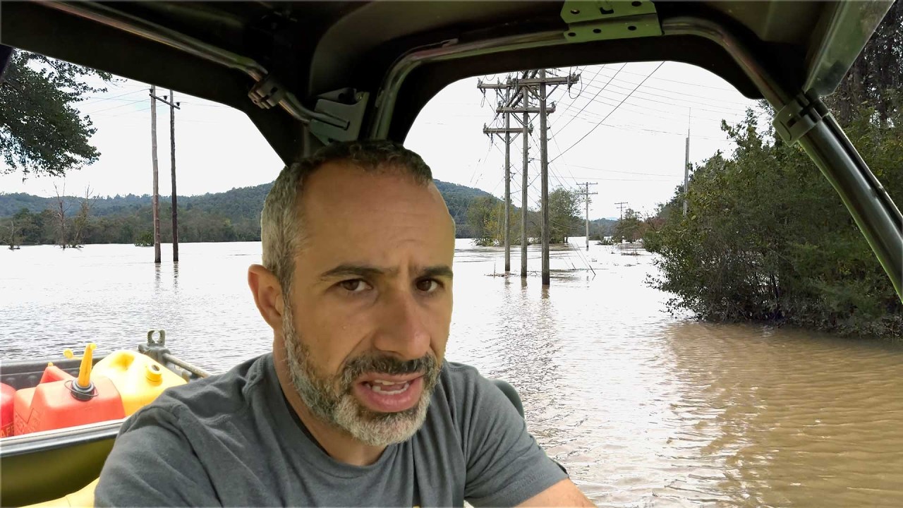
It has been a heavy week. We got hit with the remnants of Hurricane Helene as the Asheville, NC metro area and took on over 15 inches of rain in 24 hours. My family and I fared well, but others did not. We're super lucky.
Use the link in the video or a non-profit of your choice to donate to Helene restoration efforts. Better yet, bring sandwich...
Hurricane Milton gaining strength, riding between Cat 3 and 4

0800 UPDATE -Milton has rapidly intensified into a Major Category 4 Hurricane. Data from both Hurricane Hunter aircraft indicate maximum winds are estimated to be 150 mph with a pressure fallen to 940 mb. Changes will w…

How do you know that feom this flight data?

Recon finds flight level wind of > 155kt in #Milton suggesting a 140-145kt Category 5. If 145kt, this is up from 55kt 24 hours ago, an exceptionally fast intensification tied with Hurricane Wilma

New winds just measured by the @53rdWRS hurricane hunter aircraft in the SW eyewall suggest that #Milton will shortly be upgraded to a Cat 5 hurricane with max winds of 160-165 mph as an extreme rate of intensification continues.
Not understsnding this graph...?
But at the ssme time, dang it, really feel for those who are forced to stay
Ohhhhh
Also this was just indicative that they successfully got into it- massive change of ground speed
Upgraded to Catagory 5 officially.

The NHC is watching 3 systems (2 of which are not expected to make landfall) in the Atlantic

*Not expected to landfall as a hurricane
Kirk is still being funky.

Yea, was under 24 hours between tropical storm and cat 5
...oof.

At peak they might have recorded 200+ MPH, very scuffed data at the end there.
Certainly 160 MPH.
^Important clarification, 200 MPH would have likely been a gust, and not sustained, also would be estimated derived from winds recorded at flight level.
200mph gusts is definitely no fun

Hurricane Milton pressure down to 914 mb in latest recon pass

😅 sub 900mb in the future?

Hurricane #Milton Advisory 10A: Milton Explosively Intensifies With 175-Mph Winds. Residents in Florida Are Urged to Follow the Advice of Local Officials. https://t.co/tW4KeGe9uJ
Another upgrade,
Traffic as per Google and Waze


Yeah it literally accelerated after I posted
bottom note-

"Observed flocks of birds within eye"
-They're going to be stuck there until landfall (or potentially after Milton leaves FL)
NOAA49 on it's way, will have a 2nd set of recon passes soon (ish.)

alright a pack of these models want to fight.


what is UKTI doing...?
it's just being dumb- looks like it landfalls as a major and then increases in strength over land, which is... lmao not happening.


sub 900mb.
With a storm like this, AND Helena basically disappearing cities in the Appalachian mountain range? Who wouldnt be nervously checking the sites
898mb 😮

Hurricane Milton will be one of the 6 hurricanes to reach a sub 900 mb pressure in the Atlantic.
In recorded history.
Sub 900mb and they missed a direct pass
If they got a sub-900 while missing the eye, then the actual readings will be significantly scarier
as if they are not scary ALREADY
or are they gonna pull a 180 and just full send...?
They missed the eyewall pressure, which is likely lower than 898MB

the eyewall is fucking miniscule atm.
shrunk tenfold in the past few hours-
editor's note-
small things go BRRRR with the same energy
they said what i just said! the yee has to have even lower pressures
The smaller it is- the more terrifying it is personally.
something something "figure skater moving arms in while spinning"

holy shit a sub 900
hPa?
yep. sub 900hPa
bumpy flight

From 10k to 11.2k to 9.2k in about 5 minutes.
Transponder just turned off/ lost coverage of it
Well, those madmen(and ladies) flirt with hurricanes in a aircraft. Im just happy they made it out
or at least not dead so far
The latest Hurricane Hunter Vortex data message reports #Milton's eye is 4 nautical miles wide, with minimum central pressure of 899mb, which would make #Milton the 6th strongest hurricane ever observed in the Atlantic (wrt Sea Level Pressure).
A 4 mile wide eye? #Milton is

Drops #3 and #4


Note the coordinates in the top left.

#3 had 161 kts (185 MPH) at surface
#4 had 24 kts (27 MPH) at surface.
are they not going for another pass?

Might have been damaged/ spooked by that first swing.
(Usually they do several)
2nd attempt coming through.

No matter how far you zoom in or out- areas of rotation act the same


Left is hurricane Milton,
Right is a supercell over AL.
Knew they would pull a 180
Recent drop has 185 MPH ☕
It'll likely be upgraded again
uh oh

they've got 3 recons on this.
So this is particularly interesting to the meteorology community
Heard about that in Project Owl too

Tail Doppler Radar from NOAA2. A very narrow eye wall with extreme winds likely owing to in part by conserved angular momentum. Perhaps the very early stages of an ERC. Very deep, intense eye wall convection as noted by vertical cross sections. Further strengthening is possible.
Further strengthening is possible.
Atlantic record is 190 MPH sustained 🚬
we're at 185 MPH
Milton updated to 897mb w/ 185 MPH sustained.
TLDR: Florida is FUCKED fucked
It'll likely weaken before landfall in FL
storm surge is the main concern
Specifically Tampa-
If the damn thing moves north- Tampa's fucked.

if it moves south- Tampa's not as fucked
May seem a tad cruel, but I hope the hurricane won’t be as bad when it lands
Make things more manageable for those who can’t evacuate
Best case on current forcast is a 10ft surge for Tampa.

if this strays a bit more north- I wouldn't be surprised to see that jump to 15-20 ft
If it strays way south towards like Charlotte Harbor- you'll get more of a "draw' than a "force" (Winds for Tampa would be going SW- Drawing water out overall.)

Milton grew into a Category 5 hurricane with maximum sustained winds of 160 mph over the southern Gulf of Mexico. Storm surge and hurricane watches were issued for Florida’s Gulf Coast, and a hurricane warning was issued for Mexico’s Yucatan Peninsula.
Forecast models vary widely, but the most likely path would have Milton making landfall Wedne...
i would like for these models to not split their forecasts between landfalling in FL as anything between Cat 3 and Cat 5.


We don't talk about UKX2,
UKX2 is just being stupid still.
the Tampa Bay area's main hospital and only trauma center is built on an island at sea level

Also- the flood walls they put up at typically 9 feet tall.
At current forecast- best case scenatio is 10 ft of storm surge.
Any news from the Yucatan?
Seems Mexico is getting hit bad and Florida might be off the menu.
@unborn timber Thanks for all this, it's very interesting, and free of social media hot takes, which is always appreciated.
For a sorta similar field- we hang out at the wx tag on twitter,
or "STATEABBREVIATION'+wx for specific areas
(eg- TNwx for Tennessee, ALwx for Alabama, UKwx for the United Kingdom, there's probably a few I don't know about)
This looks awful for Mexico

From what I can tell it didn't quite make landfall- area had hurricane force winds and flooding- but escaped an absolutely catastrophic situation
If this had been a bit SW (still in the ocean)- the damage would have possibly been historic, as a sub 900 mb landfall is practically unheard of for the Atlantic.
also- glad to report that people are taking evacuation orders seriously for FL,
Massive evacuation is happening in Florida tonight. This is I-75 in Tampa.
#MILTON #flwx 🌀

(6 hours ago)
8PM EDT: This is nothing short of astronomical. I am at a loss for words to meteorologically describe you the storms small eye and intensity. 897mb pressure with 180 MPH max sustained winds and gusts 200+ MPH. This is now the 4th strongest hurricane ever recorded by pressure on

"This hurricane is nearing the mathematical limit of what Earth's atmosphere over this ocean water can produce."
Theorized max for this area rn is around 190-195 MPH sustained if I remember right? I'll have to dig up the study (probably from the 90's..)
"This hurricane is nearing the mathematical limit of what Earth's atmosphere over this ocean water can produce."
Probably the spookiest quote I heard that’s weather related
I mean as long as it stays over the ocean at peak (which it seems to be doing- should weaken as it approaches FL...)- absolutely fascinating to me
this is the hypothetical example whenever you start learning about this- and it's infront of us not in the 1980's, not in 2005- but now 2024. When we have amazing open source satellites, open source radar stations, and recon data (again open source) pinging in and out of it nonstop.
This will be a triumph for meteorological studies for decades to come.
Not shocked that meteorologists will be reading up on it for a while after this hurricane lands
Not everyday a hurricane drops below 900
Also really happy that there’s satellites that 24/7 ping out data for all to look at
Yup! for the entire USA aswell! (Updates every 15 minutes- you're not going to get an "up close" scan from this ever)
https://www.star.nesdis.noaa.gov/goes/

GOES Image Viewer - NOAA/NESDIS/STAR website
Near real-time publication of GOES-East and GOES-West images from NOAA/NESDIS/STAR
Every 15 mins is close enough to live weather data for me lol
If you want live doppler radar- there's a few sources for that too- as that's also open source.
https://radar.weather.gov/
Free- not that great UI experience, you can get archives but it's a hassle
Radarscope- $8, there are subscriptions within- good UI personally, can pull archives going back to 1980 quite easily (they did the hassle for me.)
slightly outdated map- but if it starts raining anywhere in those blobs- we can see it- updates 3-15 minute incriments depending on how strained the operators put the dish at-

Average is like 8 minutes.
I often joke that if we ever get nuked- weather nerds will be one of the first groups of civilians to report it.
(That and earthquake nerds- which I am slowly being absorbed into- a lot of seismic stations are also open source- look into GlobalQuake- I have a personal server running w/ it.)
Why are all the stations on the east half all round while west is just “lol no”
not as chaotic w/ weather (partially thanks to the Rockies)
Ohhh
notable radar holes in the area-
If you can see white it's real bad,
blue- pretty damn bad
Orange- Start of the "losing confidence" range

radars are expensive as shit to put up, maintain, and also to put a NWS office behind-
Each one of these stations is part of it's own jurisdiction in terms of the NWS
May I ask how expensive?
like look at this- if you wanna report in a tornado tag/ call the right office

I myself am under Jackson, KY's jurisdiction (JKL), Part of the Appalachians- fewer tornados per year here.
but the more known variant is Jackson, MS- as that's a section of Dixie Alley (JAN)
if you're storm chasing in MS and fuck up your code/ twitter message- you may send info to the wrong office entirely
Can’t you just “get there’s some weather at (Denver)” and let the offices figure it out from there?
yeah that is usually how it works lol
Ok cool! Glad to know that tactic works well
btw- each weather station has a dedicated twitter page, Facebook page, Youtube* (some dont), etc.
Oh sweet! Not shocked though
So if you're in the USA- I recommend following your local NWS station on twitter- as they're going to alert you to shit going on quite close to you (And the more ways to get an alert the better in terms of severe weather events- also just nice to keep updated.)
also- if you're fully invested- gonna slide over this talk given by Tim Marshall in 2021 (800 views 😭 )
https://youtu.be/yPtBuEEgPDo?si=5_g1vBIOtadnwPuU
It's a good one I promise! He's working on the updated EF scale too- and lets a few things slip about that during this.
200MPH EF5 however is wild- scale currently has 201+ being EF5, 200 would be EF4, but he frequently refers to 200 MPH being EF5... would have a new EF5 awarded posthumorously to probably a few tornados post 2013...

Yea, am located in the States 🙂
Back on Milton coverage since I went on a massive tangent there (sorry!)
Here's the specific page for tracking Milton- will take a second to load as these are surprisingly high detail images per update
https://www.star.nesdis.noaa.gov/goes/floater.php?stormid=AL142024#navLink
this is the weather thread lol. As long as its weather related, im chillin
Sadly it´s gaining wind speed.
Up to 129 km/h now outside the coast of Mexico
Using this to track the wind speeds
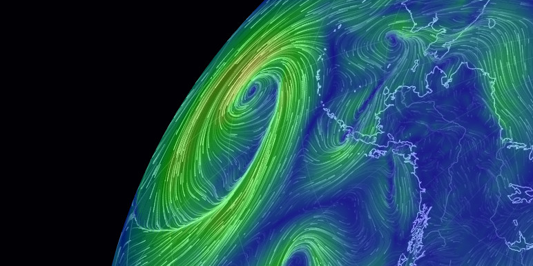
See current wind, weather, ocean, and pollution conditions, as forecast by supercomputers, on an interactive animated map. Updated every three hours.
Not that we need worse news, but I actually think Hurricane Milton may produce a high number of tornadoes prior to landfall on Wednesday.
Combo of a volatile unstable thermal environment within the favorably sheared front right quadrant may set the stage for a tornado outbreak.


Bumpy ride into Hurricane #Milton on @NOAA WP-3D Orion #NOAA43 "Miss Piggy" to collect data to help improve the forecast and support hurricane research.
Visit http://hurricanes.gov for the latest forecasts and advisories
Visit http://noaa.gov/milton for information that you can use before, during, and after the storm
bumpi
We flew over Hurricane Milton about 90 minutes ago. Here is the view out the Dragon Endeavour window. Expect lots of images from this window as this is where I’m sleeping while we wait to undock and return to Earth.
Timelapse coming in a separate post.
1/6400 sec, f8, ISO 500

I wanted to take a moment to say I appreciate how you all are talking about this storm. Other areas of social media are very, "Florida is fuuuuuucked" and "I wonder what will fall down" and on and on. Which is, uh, quite a vibe for people in this community in the path of the storm.
I also have to say that I appreciate not seeing any "the people who don't evacuate are stupid" or similar takes. If you've not tried to evacuate for a hurricane you don't know about the jam-packed highways where it takes hours to go a half mile, or gas stations that have run out of gas, the endless logistics. If you're unfamiliar with that experience and interested, let me know and I'll get some information for you.
Proud of this community as always!
White House launching Reddit account with updates on hurricane response, preparedness
I'm bogged down enough getting data in- i rarely have time to make dumb takes lol
Also if tomorrow acts like forecasted- could have a bit of a tornado flurry in southern FL- if so yay more work 🙃
also will say- if this storm holds forecast/ strays slightly north-
Tampa is fuuuuuucked (scientific term.)
if it strays south of the inlet- Tampa's probably banged up a little but aight (Port Charlotte however could get fucked instead- again, scientific term.)
Right now the "highest probabilities of eye landfall" are barely south of the inlet- but notably still has the potential to stray as far North as Homosassa Springs

Reminder- damage will extend further than the cone- cone is trying to predict where the center will be.
one last note in the flurry of messages (probably)
a couple of gauges are predicting records already (circle is observed, square is predicted)

Also- Milton weakened overnight (as expected)- but earlier this morning intensified back into CAT5 territory- waiting on the next recon pass to see where it's at now.
Last pass (2 hours ago) was at like 920 mb, if this hurricane goes sub 900 twice in it's life- it'd be a first, a very dumb first.

This is also thanks to you blue and green names for keeping an eye on things and making sure the "dumb takes" people are managed. Storms like this can easily bring out emotional responses, especially if theres people you hold close in the area
Really hope that everyone stays safe, and emergency responces come quick

I've been in and out of this channel, but watching elsewhere
I do my best to steer clear of "opinions" and just focus on watching the storm happen, and hope as many can get out as they can. I'm a midwesterner, and despite the "puts out lawnchair" attitude we portray, we really hate people getting hurt.
Should be the standard. We as humans are stuck on this rock together, least we can do is help someone out
I do not want there to be people stuck there, and I recognize the ones that are, are by and large just stuck
Some people are forced to be there, such as first responders, poor, disabled, so on. It SUCKS seeing people there, especially after the news and info that this hurricane will be messed up
mhm
anyway it's calmed down here after tornado season, the news is that the fire danger is very high
prairie desert hours
Can’t catch a damn break with weather… apparently France is gonna get broadsided with a cyclone too???
Gonzo releasing dropsondes into the storm
https://vxtwitter.com/NOAA_HurrHunter/status/1843827946328633769

Releasing dropsondes into Hurricane #Milton from @NOAA Gulfstream IV-SP #NOAA49 "Gonzo."
The G-IV flies high altitude missions above and around the storm to collect atmospheric data that helps refine track forecasts.
…
Can’t wait for the data from that
post-cyclone Kirk yeah
Hurricane Leslie looks like it's spinning out in the middle of the Atlantic
As a fellow stand on the porch, tell someone it smells like rain, observe thunderstorm Midwesterner, I've seen tropical storms/Cat 1s be cause for a "hurricane party" in New Orleans where everyone hunkers down together and fills coolers and helps each other and it's sort of like a camping party.
But it's all serious business for the bigger ones
Reminder that Nadocast is good- tends to act wonky w/ tropical cyclones. Think of this as "worst case scenario" forecasting for this.\

but yeah- there is likely a tornado threat for a good chunk of Florida across the 9th.
Personally- i'd put it at 5-10% (Maybe a tiny area of 15%? Uncertain.) , one or two could be strong.
A minor selection (Like 4 out of 9 typically used) of different model runs for the same point of time.


All of these show a pretty notable chance of a tornado outbreak just prior to landfall.
Also HAZCAST threw a 18% for 1hr max tomorrow
Still testing to see how reliable that is w/ tropical setups- newer and much more "guarded" AI model there.
But overall- rough AI model agreement, human forecast currently is a bog-standard 5% for the area- will have to see if it gets updated in 3 hours. (Also- recent model runs are leaning towards 10% minimum for a small area in my opinion. Sorta in between human and AI.)

We’re going to do fieldwork in Peach County, GA tomorrow. Fingers crossed that we won’t get rained out. I think we will be out of the range of the bands. What do you think @unborn timber .
You're likely goin to be rained on- lemme check the excessive rain forecast.
Most of GA shouuuld be aight


Thanks friend! If it was up to me, you would be financially compensated as a weather consultant to our firm. Keep doing what you do. We love you!
Acedog is clutching hard as this servers westherperson
Agreed!
ironically would be the 3rd company to say that
one of them was a roofing company-Afterwards I sorta keyed into the fact that they were looking for work and wasn't quite happy 🙃
(Hopefully they offered fair rates to those who lost their roof)
At this rate, I consider whatever Acedog says about weather to be legit, even if bro doesn’t provide sources 
i provided the excessive rainfall outlook :C
Milton is back to 185 MPH sustained winds :L

A different drop shows Milton is back to 910 mb
(Still has only gone sub 900 once, but it keeps chipping it down)


Welp they added the 10#


...#MILTON REMAINS A CATASTROPHIC CATEGORY 5 HURRICANE...
...FORECAST TO MAKE LANDFALL ON THE FLORIDA GULF COAST LATE TONIGHT AS A DANGEROUS MAJOR HURRICANE...
Follow http://Hurricanes.gov/#Milton for the latest advis…
Officials say Milton, currently under category five status, could be the worst storm to hit the area in about a century - with a surge of 10-15ft (3-4.5m) possible, and localised rainfall of up to 1.5ft.
six inches of rain inundates us here in Nebraska, I can't imagine one and a half feet

The 👁️ of #hurricanemilton2024🌀 during a mission Oct. 8.
Listen to local officials, evacuate if told to do so, and stay #weatherready https://t.co/gCZAwSAx5z
Godspeed to those brave lunatics who see what is effectively a cylinder of wind and water and instantly think “cowabunga it is” and jump in an airplane
to be fair, they're in one of the best planes for it
it's hard to break those old P-3s
They still go “cowabunga it is” and full send into the cylinder of wind and water
Oh yeah, just saying the airframe helps
Not denying that!

Port Charlotte is in trouble

JUST IN: Tornado captured by drone south of Lorida, Florida.
@SevereStudios @MyRadarWX
#flwx #tornado
There's been quite a few tornadoes today


Likely a violent tornado ongoing in FL


Likely just had 3 strong if not violent tornados occur at the same time
What area (roughly) are we talking?


Very strong tornado heading towards Yeehaw Junction, FL


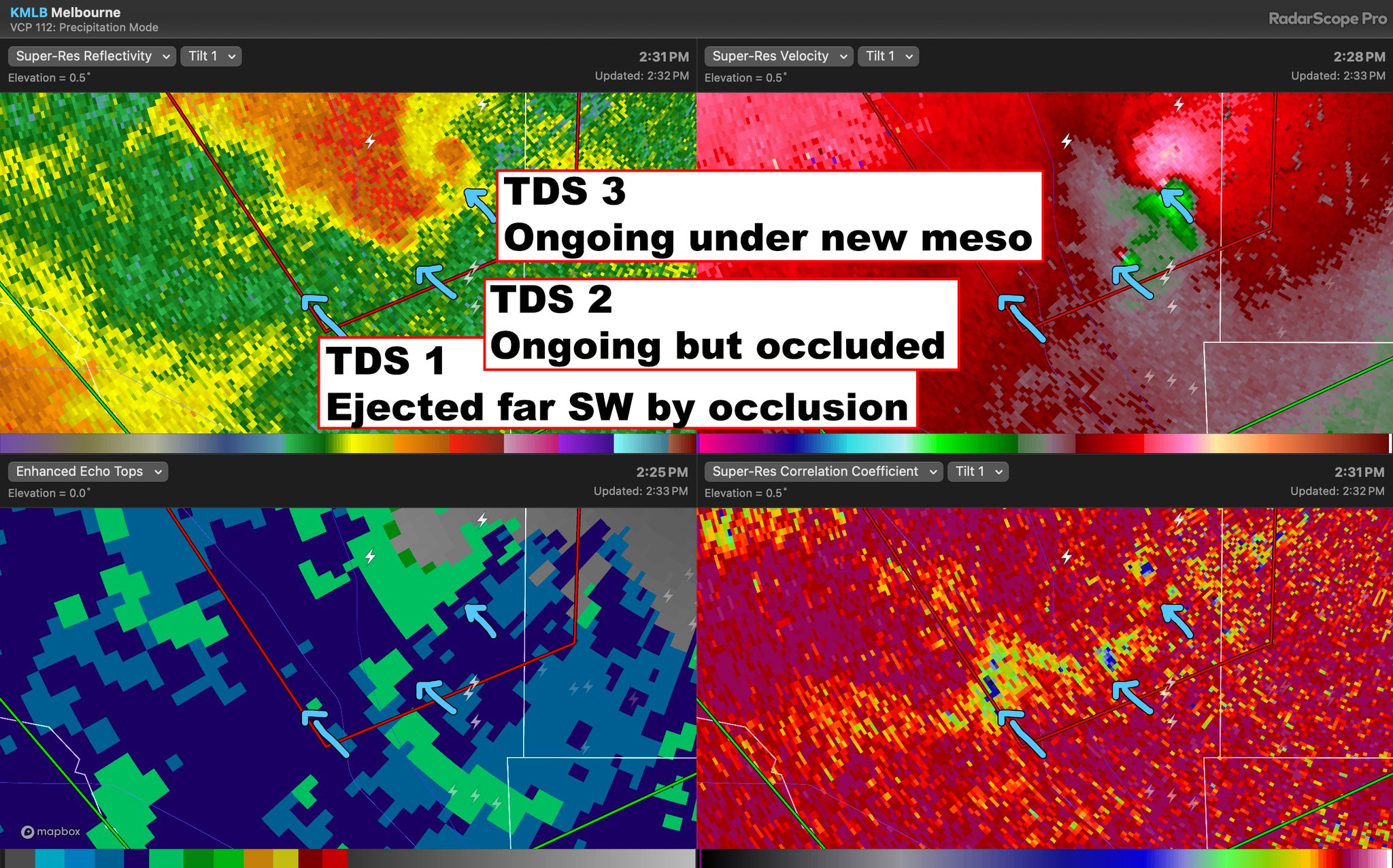
#1 is showing reflectivity+ Velocity,
Images #2 and #3 show reflectivity+ CC, that pocket of lowered values is indacative of debris in the air (especially when alligned w/ previously mentioned ref+vel values.)
Reports of vehicles overturned near Port Saint Lucie, likely tornadic damage.
Cycled- new mesocyclone location is a bit NE

Already tornadic- Yeehaw Junction likely got spared from a massive hit.
Well that's unfortunate. NOAA's water level monitoring buoys seem to be down. The website part of it, presumably.
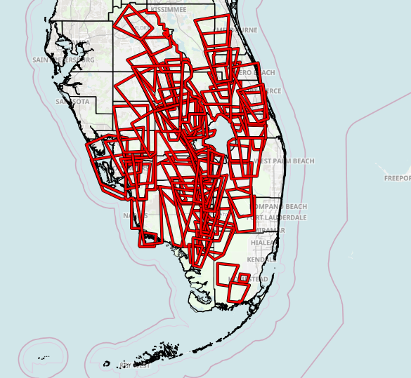
10/9 at 3pm: Here is a view of all of the *Tornado Warnings* issued by NWS Tampa Bay, NWS Miami, and NWS Melbourne thus far.
As of 3pm, 53 total tornado warnings have been issued today...
41 issued by NWS Miami
Please remain aware for current and future tornado warnings!
thank fuck it cycled 😅

That's likely another strong tornado just north of the area.
New tornado probably starting up just NW of Port Saint Lucie

just an update- yeah- tornado active here.

Sneaky fucker- in a radar hole.
Likely active, tracking over previous tornado damage-


this fucking storm N of Yeehaw Junction keeps producing pairs of tornados at a time (This is like tornado #6 or #7 from it.)

This cell extremely dangerous in my opinion
This one's also heading for Port Saint Lucie..

Central FL update- This cell's probably produced another violent

Incredible cyclic behavior by these supercells in FL, The Yeehaw Junction supercell producing three potentially significant tornadoes back to back with twins ongoing during both cycles.
Mereologically- pretty nuts,
Logistically- fuuckin stop storm before you get over populated areas
Observed tagged warning going into Port Saint Lucie now- Unsure if there's a tornado on it still- radar might not be having a fun time w/ the area though.
No one in Florida is having any damn fun for the past month
I'm going to be out for the next few hours- Ryan's typically up there w/ resources for live weather watchin

Support the channel here: http://www.shopryanhall.com
Internet provided by: https://isptek.co/
Support the Y'all Squad here: http://www.theyallsquad.org
WANT TO BECOME A MEMBER? CLICK HERE:
https://www.youtube.com/channel/UCJHAT3Uvv-g3I8H3GhHWV7w/join
VIRTUAL RAILFAN
https://www.youtube.com/@VirtualRailfan
________________________________...
WOW - using 0.8° for velocities, it would appear that the new cycle of this extremely prolific tornado-producing supercell now an ANTICYCLONIC tornado with it's own debris ball and couplet ALONGSIDE the intense parent tornado #flwx

also yeah- anticyclonic tornado from a TC supercell 😵💫
'preciate it, I'm in there now
new warning just dropped


BREAKING ALERT: Violent tornado recorded in Fort Pierce, Florida.


This is PTDS- which is effectively sorting through CC+ REF and detecting what it believes to be a debris ball
This one is confirmed and is used to help note where this tornado tracked.
storm surge is chewing on the shore now

What channel is that from?
Support the channel here: http://www.shopryanhall.com
Internet provided by: https://isptek.co/
Support the Y'all Squad here: http://www.theyallsquad.org
WANT TO BECOME A MEMBER? CLICK HERE:
https://www.youtube.com/channel/UCJHAT3Uvv-g3I8H3GhHWV7w/join
VIRTUAL RAILFAN
https://www.youtube.com/@VirtualRailfan
________________________________...
CW: disorientation
https://vxtwitter.com/NOAA_AOML/status/1844115360997654917

Inside Hurricane Milton, @saildrone reported wave height of 28.12 feet and wind gusts as strong as 75.95 mph while 40 nautical miles from the center of the storm. This research represents a collaborative endeavor to bet…

Just went over to check on Lieutenant Dan during a break in the weather - he just cut one of his lines because he said his boat was hitting the wall but he’s ok.
Everyone's sorta watchin to see how this dude fares.
He's in Tampa
WELLINGTON,FL **TORNADO TOUCHDOWN** 16296 DEER PATH LN - CALLER HYSTERICAL REPORTING HOUSE IS GONE - POSSIBLY 10 PPL TRAPPED IN RUBBLE - OPS TAC 8 #BREAKING
Looks like Milton will landfall juuust south of the inlet to Tampa- storm surge should not be as bad
(Should mainly draw water out with W/SW winds)
MesoVort #5 in Port Charlotte is giving the most impressive storm surge footage
Birdfall?
Oh shit, i assume dead?
Not as long as there's a blue signal. https://vxtwitter.com/matthewcappucci/status/1844137957181317212

BIRDS 🕊️ in the eye of Milton. Those blue signatures represent spikey/jagged/irregular shapes not representative of rain. Likely the birds that have been pulled into the eye, where they can’t fly out due to powerful inward winds. (Imagine being caught in a whirlpool.)@MyRadarWX
Fun note- that blue line on the left is likely a hail spike at the NE spot

WPBF
St. Lucie County officials confirmed to WPBF 25 News that there are multiple fatalities following tornadoes in the area.
yeah they're sea birds, they'll by and large be ok
just very confused
welcome to the new intersection of 22nd and Manatee

Milton made landfall at Category 3
Looking grim in Nottingham. 😉
https://vxtwitter.com/simonoking/status/1844247582220091844
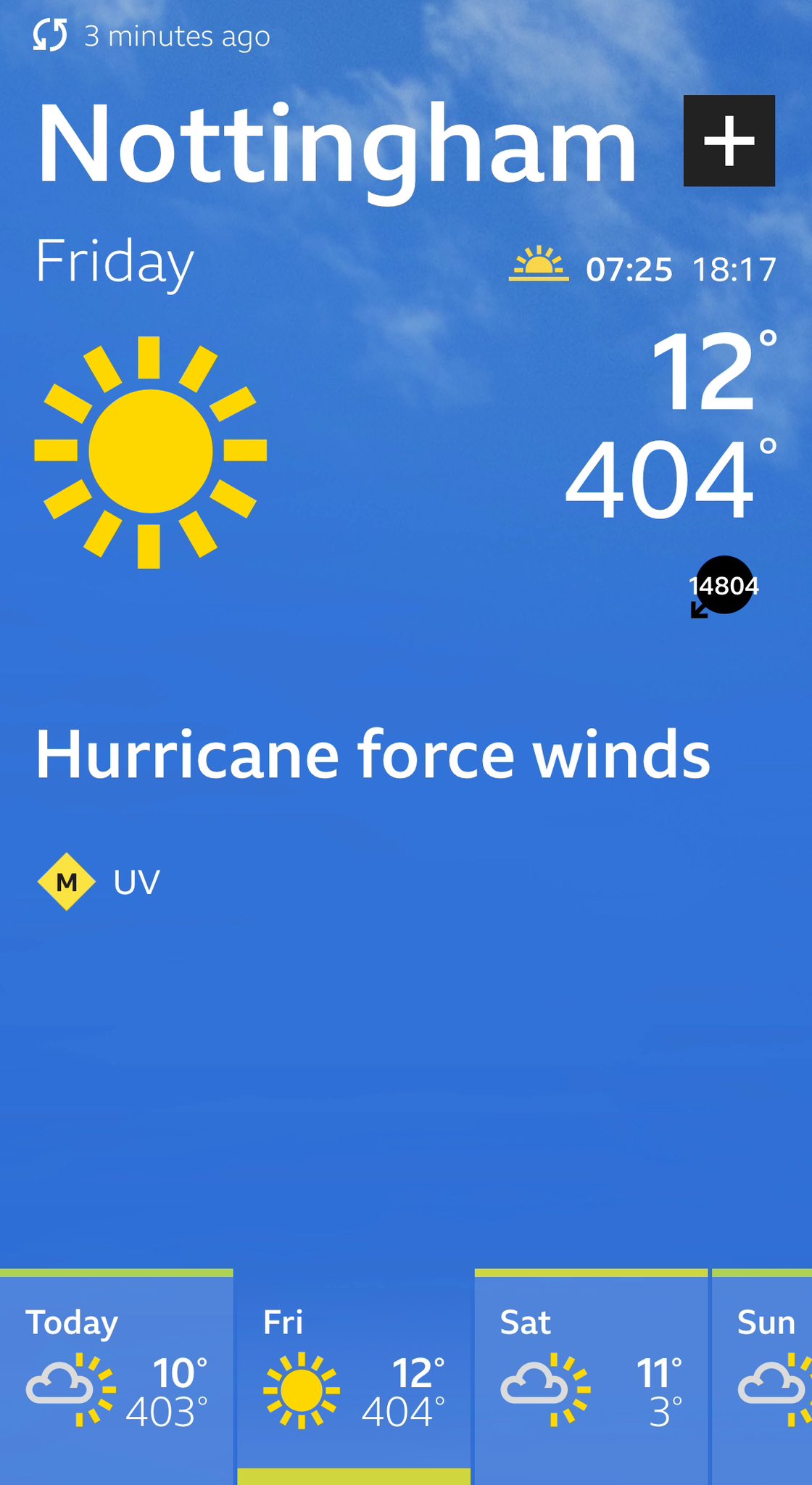
Oops, don’t be alarmed by some of our @bbcweather app data this morning.
Be assured there won’t be 14408mph winds, hurricane force winds or overnight temperatures of 404°C. 🤦♂️
It is being looked at and hopefully sorted asap 🤞 https://t.co/Fjgw15s8ej
Across the UK apparently.
Yeah, this happened to be the first I saw. Funny that daytime temperature isn't affected.
Strange indeed. Must be the government  !
!
current outages in Florida post-Milton https://poweroutage.us/area/state/florida
PowerOutage.us tracks, records, and aggregates power outages across the United States.
almost 3.4 million
Do geomagnetic storms count as weather?

"reverse engineering" tornado probs using tornado reports then creating a graphic afterwards-
This would be the "theoretical perfect" NWS forecast that would have been issued, which as you can tell- is a bit absurd in this one

West Palm Beach… video from Robert Hubert
Very close view of one of the tornados yesterday
Tornado hits Avenir in Palm Beach Gardens in my in-laws neighborhood. A dumpster gets lifted onto a roof. Unreal.
@WPTV @SunSentinel @WPBF25News @wsvn @FOX29WFLX
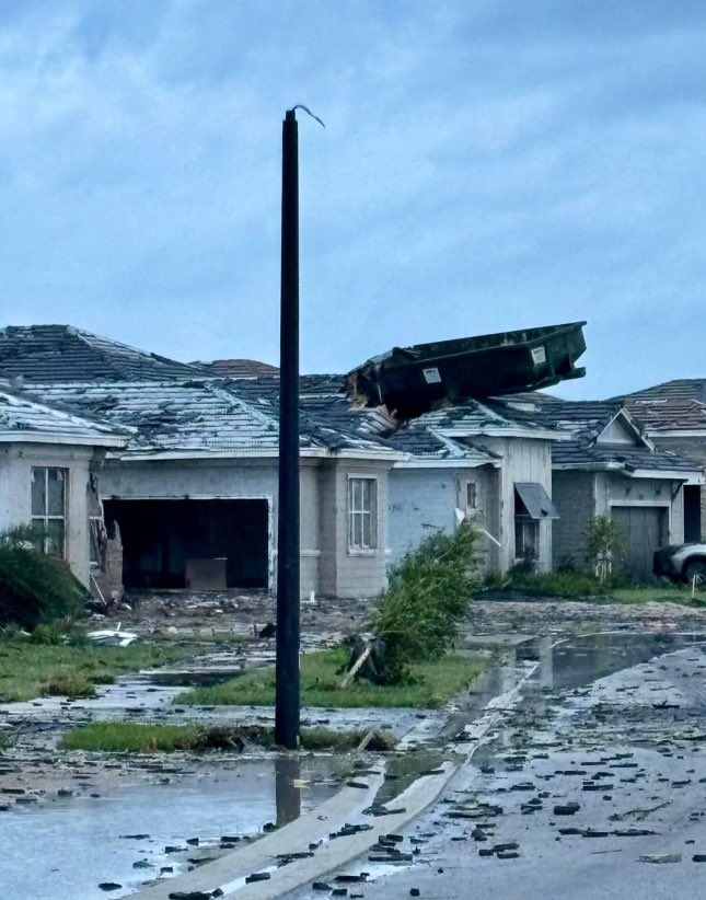
Course- one of the more wild instances of wind driven projectiles lately.
Aurora right now in north cap, Norway!!
@landon_wx
@theauroraguy
@TamithaSkov

*Preliminary* EF3/140 mph DI in the DAT for a well-built home impacted by the Wellington, FL tornado yesterday.

Very well built house
My local power district is sending their mutual aid team down to Florida to help restore power https://oppdthewire.com/oppd-mutual-aid-crews-facing-tough-conditions
OPPD’s mutual aid team is now in Orlando, where it will help with restoration efforts in the wake of Hurricane Milton.
the DAT currently has a 0.32 mile long EF3 marked

As it were, I'm around ground zero. Thought I'd pop back in for a bit since I'm going to assume no one else is able to get to where I physically can. So...please let me know how I can assist.

The Ovation Aurora Forecast by @NWSSWPC for the northern hemisphere. Does it slightly underestimate the extent of aurora visibility as I saw nice pictures of auroras taken by my colleague at Princeton, NJ.
Photos from a friend in MN

I saw them here in SE Kentucky,
...barely.
30 second exposure vs a 65 second exposure


^ The last event was much better for me- 15 second exposure.
(No actually this has to be like 5 seconds max because it's handheld. I'm not that steady.)
btw theres a Space Weather Prediction Center that tracks this

when I say I have an interest in weather, I mean all weather lol

Tornado Warnings, as they happened during #Milton. At one point there was nearly 15 active tornado warnings at the same time.
The only reason why the USA didn't see 100+ tornados from Milton is because the FL peninsula is skinny.
ooh you can see the spin off the hurricane

Watch as a tornado rip through a patio in Palm Beach Gardens, #Florida a couple of days ago. #severewx #FLwx

Also don't worry about the location tags- they're optional for the storm chasing group i'm in- "Closest 'big town' to you" for reporting weather events without having to say exactly where you are every damn time.
Probably bad opsec- but good for us logistically for reporting shit (such as flooding)
I use the closest weather station
Oh that is not a good idea for some of us on the border of 2 (+)
Like i'm under NWS Jackson, but I use NWS Memphis's radar more often (Because I tend to chase more south of where I live.)
also we voluntarily put GPS trackers on our phones while we go chasing- usually with the whole "name/alias", "phone number", "email" layout so that's probably asking for trouble... Especially w/ all of that being open to the public.
That's a chaser standard btw- Spotter Dots via Spotter Network.
I'm more of a "watcher" than a "chaser" tbf :P
Wooo we finally get one unit of fall https://x.com/NWSOmaha/status/1844854547312988285
Our warm streak is heading for a cooldown this weekend, with areas of eastern Nebraska and Iowa expected to see some frost to start the mornings next week.

i hate the cold, it's rough and corse and irritating and it gets everywhere
I like being warm in cold places


#HurricaneHelene #PowerOutage Summary.
Max customers out at one time: 4.79 million
Total customers Affected: Over 7.4 million
Over 1.69 million customers affected in #Florida
1.59 million in #SouthCarolina
1.28 million in #Georgia
1.18 million in #NorthCarolina
https://poweroutage.us
jesus
Bloody hell
Heads up to all of our local fire departments, our weather satellite has already detected 4 fires this morning, and given the very windy and dry conditions, additional fires will be possible this afternoon. Please do not do any outdoor burning today or dispose of cigarette butts.
fall in Nebraska yeehaw
Another day of extreme fire danger is expected today across the entire forecast area. Please do your part to prevent fires today, as fires will start easily and spread rapidly. Additional information can be found at https://t.co/pSucZ51NOa
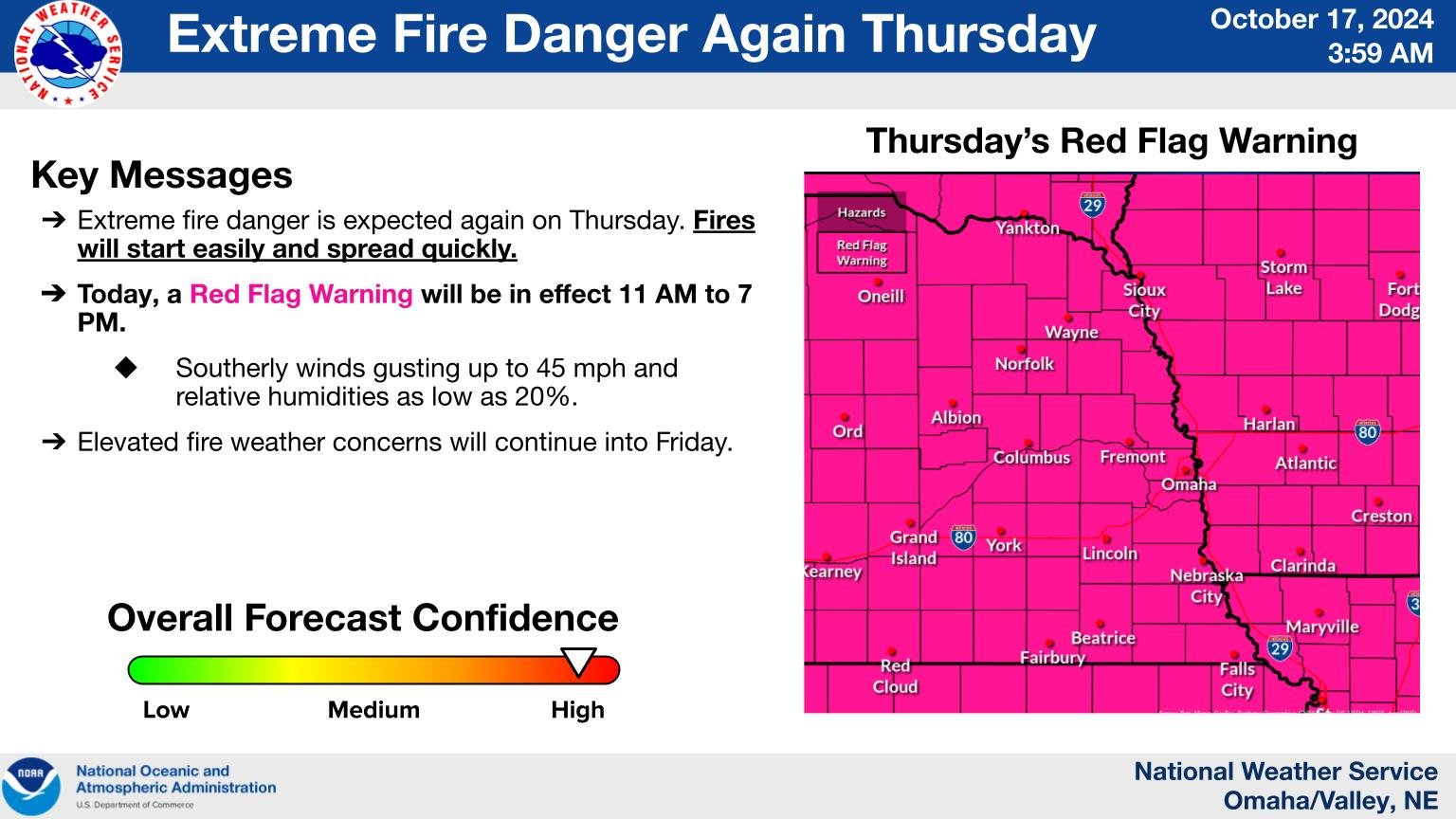
all of the fire danger
Super full moon tonight

We now have Nadine & Oscar out there! Nadine will traverse across Central America & it looks like Oscar will just kind of hover around Cuba / Bahamas for quite some time.
two storms out there now


SURPRISE! We have a surprise hurricane. Four hours ago, Oscar didn’t even have a name. Now it’s an 80 mph Category 1.
How does this happen? Oscar is so remarkably small that it can gain and lose strength very quickly.
Hurricane-force winds only reach out FIVE miles from center!
huh, that is tiny on the scale of hurricanes
Convection Outlooks may look different sometime in 2025

What it'd look like on a typical graphic-

One month later update on my personal tally (Scoured Facebook for missing persons posts) using these reports.
15 missing were found deceased
38 missing were found/ reported as alive
2 still missing (1 presumed deceased atm)
1 was identified as a dupe submission (error on my end.)
1- Unknown (Post was deleted, cannot find any level of update- presumed found alive.
From what I can gather there are still 20-25 people still missing from the effects of Hurricane Helene, mostly in NC.

meanwhile in Nebraska, Normal October continues


BREAKING: School and work have been canceled across Taiwan, except for outlying Lienchiang and Kinmen counties, on Thursday, October 31, due to Super Typhoon Kong-rey.

Typhoon Kong-Rey is huge.


In Spanish, but this is a good rundown on the particular type of supercell (there have been tornado warnings in the area yesterday and today in Barcelona) that led to the deadly floods in Valencia https://www.newtral.es/dana-valencia-mediterraneo-caliente/20241030/

Newtral
Las altas temperaturas del mar, por la emergencia climática, han hecho de esta dana una de las más destructivas en la costa mediterránea.
Also going through how climate change impacted this event and made it more extreme than other similar cold drops
Well they expanded the tornado risk to include OKC in the SIG TOR parameters.

it's damp here in Nebraska, but at least the fire danger is gone for now 😬
First tornado warning of the OK/KS event day- In Iowa, never change weather, never change.
lmao
Had some drizzle over here which is a very nice change of pace
2nd warning is in KS- but about to leave the state.

again- never change weather, never change.
New watch for Tulsa OK has 70/40 odds 👀


Gonna fuckin laugh if this current line kicks up as it leaves KS into MO
Cause there's straggler cells ahead of the line up there near Kansas City, and that's prolly the biggest concern (once they get fully goin in like an hour or two.. or three... or never)


Damage from a nasty feeder band that that swept across the coast 30 mins ago #typhoon #kongrey #taiwan

An incredible case to support @CameronJNixon 's Nudger theory tonight as a potentially intense tornado touches down in Northeast OK! Wow
Possible tornado ongoing east of Fairland
#okwx @NWStulsa

Probably had three tornados yesterday, 1 was in Iowa, 2 in Oklahoma.
Cross-posting this from #eu-uk: A water sprout/tornado has affected the municipality of Isla Cristina, Huelva (Spain) https://fixvx.com/Meteohuelva/status/1852020403297812910

Impresionante la tromba marina que acaba de afectar a la localidad de Isla Cristina.
Ha tocado tierra y ha ocasionado algunos daños materiales.
Autores de los videos desconocidos. https://t.co/c7yoSnePCk

A giant croissant seen on the sidewalk during Typhoon #Kongrey in Taiwan #颱風 #康芮
satellite image of the flooding in Valencia


the Guardian
Weather agency says four regions remain on amber alert because of risk of rain and storms
We've been covering more of it at #eu-uk


this video is geolocatable
https://fxtwitter.com/ReedTimmerUSA/status/1852821987061882923

BIG-TIME #TORNADO west of Oil Center, New Mexico! @ChrisHallWx @NWSAlbuquerque
Geolocated to || 32°28'19.66"N, 103°21'25.49"W, via Raz Oil And Gas LLC seen at 40 seconds in the video.||
..you aight there NWS?


Had a strong tornado go through part of OKC
MAJOR TORNADO DAMAGE sooner road and 84th st. In del city/ okc
@NWSNorman


Pictures of the tornadoes that were produced by a long track cyclic supercell between Byers, TX and Waurika, OK very close to the Red River crossing. Big multiple vortex bowl at the beginning then had two simultaneous tornadoes as it passed Red River. #txwx #okwx #wxtwitter
Damage survey update: Our team found at least EF-3 damage in the vicinity of Harrah. Analysis is ongoing.
testing to see how forwarding works for this
EY IT WORKS!
my fingers may be spared from the needless task of ctrl+C, ctrl+V 😭 (such a challenge)


Ai is going nuts over today's event (currently starting)

First lil sign of things to come,

Now tagged as an Observed Tornado
Tornado Warning continues for Nowata OK, Talala OK and Jamestown OK until 1:30 PM CST

^Downgraded immediately, likely had a bit of an error

A tornado watch has been issued for parts of Arkansas, Kansas and Missouri until 9 PM CST


Tornado NW of Talala minutes ago @NWStulsa #okwx


Fujiwhara effect ongoing!


TORNADO NOTCHIETOWN #okwx

INSIDE TORNADO LAKE TENKILLER @NWStulsa
^Later became a pretty strong tornado

Christie, OK likely hit

wha happun
I'm the "dude you go to for geolocation work" in several communities- Including this one ran by a YT'er friend of mine.
tl;dr- YTer I know spent 2 hours bashing his head in on a geolocation attempt, pinged me for help at 1 AM and then found it 5 minutes later
Idk how to get this flavor of knowledge, but YES PLEASE
lmaooo


If you want to play along- here's the full image. 1999 Bridge Creek- Moore F5

I personally believe this area is close to (but not exactly at) || (35.203673210981336, -97.73580758265588) ish, Looking towards SW Bridge Creek.||
@VinceWaelti @SimonStormRider I would just mention whoever you are talking shit about in the future from here on out. You talk so much shit all the time it is impossible to tell. Simon should have mentioned me also. Weird comment
...Weather twitter is going nuts rn
Can you please ELI5 this to me?
What’s the drama?
Just some anger goin around honestly
Reed's one of the "founding fathers" of the field imo- but he's always been a pretty gray zone character imo.
@reich_sindy @SimonStormRider @VinceWaelti It’s all on me, Sindy!! I get a lot of negative feedback for being too loud and excited, and saw these two comments and took it personally. I then called out 30 years of frustration dealing with similar type of comments/energy from my male
peers, but I understand. It sounds like
think we're resolved 👍
weather community update while we're between severe events-
mass exodus from twitter from us
Scattered across BlueSky, Mastadoon, and any other site you can think of
Bluesky is a pretty fucking good social media, snag an account there

The Weather Network
A rapidly intensifying storm will threaten some hazardous conditions across B.C. through the first half of the week
This damn wind, aaaaaaaa


So i've been silent for a bit- I've been working on a new EF scale for personal use.
Not even really changing much! Just sub dividing each EF category into Low End, Mid Point, and High End ratings to further subdivide the uncertainty between each one.

Here's my bullshit math dumbassery to figure this out.

Id offer up a 2 parter for this: a "wind rating" and a "damage rating"
Well- We derive the wind estimates from the damage
its easy to imagine a 200+mph tornado just ripping through fields damaging like 2 houses
Sure, its a 200+mph tornado, but damage might as well be zero
The EF scale is already sorta an amalgamation of both lol, El Reno 2013 for example had over 220 MPH recorded winds, hit like 2 poorly built houses, and was given EF3.
Why not make it simple and have 2 ratings?
Internationally there's like 5 different tornado scales
Key word: amalgamation
EF(USA), F(Pre 2007), IF(International), TORRO(Europe), "Modified EF"(Canada) and a few others i'm forgetting off the top of my head.
The biggest issue is that there's no good tools that can consistently get wind readings of a tornado without promptly being fucked up themselves.
Even radar (including the DOW here) scan above what the winds are on the surface, and typically record higher values.
(Typically)
They can be scanning 400 ft above the surface, 1,500+, 4,000+ It depends how far out the radar is.
Yea, maybe someone needs to make a portable (well, "portable") directional radar so people can point it right at the base for the most part
That's the DOW (Doppler on Wheels)

So people do that, neat
It's tough as shit to get set up usually, and you'll be getting like.. one storm a day with each truck.
Good odds that storm doesn't go brrr and produce too,
I always joke that if you're a meteorologist, you're very fuckin unlikely to be a gambling addict, because our fuckin primary hobby is chucking ourselves at 5% odds day in, day out hoping for a jackpot.
Same with a mathmatician who focuses on statistics
High school teacher who taught that said "gambling is a scam, i checked the numbers myself"
That's what Meteorology primarily is! It's a bunch of dumb math with a bit of pattern recongnition.
Nice
I'm gonna take a nap because holy shit I spent a real stupid length of time figuring out the midpoints of each rating, then realizing they would be forced to overlap under the new EF revision set to be released soon ™️
(Calculating the midpoints of the hex values for the colors was fucking easier!)
ex CURRENTLY, 110 MPH is EF1, 111 MPH is EF2,
Under the new EF revision, all MPH estimates will be rounded to the nearest 5 MPH- uh oh.
I derived a system like so- If it rounds up, it is marked as "110-", indicating 105 < x< 110, If it rounds down it will be marked "110+" indicating 110 ≤ x< 115
If you look at the current EF scale- it seems like this was the original intention back in 2007 aswell, but they settled on making it easier by just setting each division at +1 MPH

The biggest controversy I can see from my scale is that.. well, 200 MPH exact would be EF5 going strictly off the pattern set,
This does allign with what TIm Marshall (Notable damage assessor who is working on the new EF revision) has mentioned, He has also stated 200 MPH EF5 a few times recently.
....Currently there are a few tornados rated 200 MPH EF4.
Full text: Tsunami warning for parts of California and Oregon


Mighta had an aftershock- would have been BARELY felt on the surface, M3.5 estimated
Attached is one of the seisographs for the area.

Hexagons follow the MMI color scale for estimated (local) intensity.

Important note that the program i'm using has pure estimations using publicly accessible seismographs, don't expect my values to be exact
NOAA’s tide gauge website is down apparently according to @visual sphinx
Might be a useful webcam:
https://www.windy.com/-Webcams-Crescent-City/webcams/1635184770?41.872,-124.244,10

Might have been moved.
Also sorry about the scuffed link- it apparently adds my filters and where I was last looking
What program/website?
Full tsunami watch area- Effectively from Reedsport OR to just S of San Francisco is included.

This is GlobalQuake, there is a version being livestreamed 24/7, I have my own version running which will differ somewhat.
https://www.youtube.com/watch?v=rvtygG4n6ew
Important note- This will sometimes catch false positives. There's a whole course in understanding the UI in itself
Weather and geological phenomena
Hell yea, thank you! Sometimes catching a false positive is alright, since it proves that the sensors are working
Don't have time to go through this now but reupping this forum post full of livestreams https://discord.com/channels/709752884257882135/1144296259805528256
There's probably relevant ones here
If you do go to run it yourself- you can pull up each station-
Important UI things to look for- Top left, Program estimate of magnitude+ MMI scale, Revision #, Estimated epicenter location, Quality is a big one- Higher letter grade= more stations reporting it= more certain in estimations.
Just under that is the "Magnitude scale"- Basically "what are the odds it's X intensity given the data we have", and to the slight right of that is Stations used and a bunch of other fun data that you probably wont need.

Main worry personally is the moment a relatavly strong earthquake is felt closer to Washington State, thats whole coastline might be gone
For up to date (and more official) reports, always refer to https://tsunami.gov/ and also- https://earthquake.usgs.gov/earthquakes/map/
(You honestly don't have to fiddle with setting up connections to seismograph stations yourself, I just do it because i am a nerd.)
Estimated start times for some selected areas. (If a tsunami does occur for these areas.)

WEAK51 PAAQ 051954
TSUAK1

BULLETIN
Public Tsunami Message Number 3
NWS National Tsunami Warning Center Palmer AK
1154 AM PST Thu Dec 5 2024

...THE TSUNAMI WARNING IS CANCELLED...

 * The Tsunami Warning is canceled for the coastal areas of
   California and Oregon


OBSERVATIONS OF TSUNAMI ACTIVITY
--------------------------------
 * No tsunami observations are available to report.


RECOMMENDED ACTIONS - UPDATED
-----------------------------
 * Do not re-occupy hazard zones until local emergency officials
   indicate it is safe to do so.


IMPACTS - UPDATED
-----------------
 * No destructive tsunami has been recorded.

 * No tsunami danger exists for the U.S. west coast, British
   Columbia and Alaska.


ADDITIONAL INFORMATION AND NEXT UPDATE
--------------------------------------
 * Refer to the internet site tsunami.gov for more information.

 * Pacific coastal regions outside California, Oregon,
   Washington, British Columbia, and Alaska should refer to the
   Pacific Tsunami Warning Center messages at tsunami.gov.

 * This will be the final U.S. National Tsunami Warning Center
   message issued for this event.

$$
Well, you sniped me on the tsunami cancellation
Still keepin an eye for aftershocks for the next.. probably hour.
-30.56199162499195, 128.99401256520997 @unborn timber lol check this out. Tornado scar
Yeah- there's a good few that only get ID'ed from satellite imagery later- There's a good thread on Twitter (somewhere) about North Korean tornados.
I love how people look around only to see undocumented tornados like “ayo wut”
also no offence but Google served me quite literally all of these to my phone like a few days ago.

(Google News alerts lol)
I know you as the “Bellingcat Tornado Member” so the algorithm be hella strong for you lol
My life is staring at Google Earth for tornado paths too lol, got me on two fronts
lol

Majority of the reports so far are on the scale of "felt it- nothing really damaged"- Woke many people up lol.
https://www.emsc-csem.org/Earthquake_information/earthquake_map.php?id=1740821

Glad to know no one was seriously hurt, if anyone even got hurt to begin with
I'll be inactive in this server- if you need me, ping me/ DM me. Will not check this server.
NWS outlook for tomorrow- Looking at a potential strong (EF2+) tornado in theory (Likely wont get one.)


....aight i guess.

Screw Rockwall in particular I guess lmao

Nadocast does have a notable population bias (it's ran on weather data+ storm spotting reports from those prior events, more people in an area= more reports)
Hell yea
Just realized you weren't talkin about my post rip.
Still love how there’s basically NOTHING in Dallas but weather went “lmao screw Rockwall” with lightning
In like 3 hours, check Houston***. (oop wrong city)
aight bet
Upgraded to ENH, New tornado probs.


A tornado watch has been issued for parts of Louisiana and Texas until 7 PM CST


Yeah- Houston within the next 3 hours.

Events starting to kick off- Start of the event around 3-ish,
just a mini archive for myself.


Tornado in El Campo, Texas happening now
To no one’s shock, the Bellingcat servers resident meteorologist is correct about meteorology
(Just to be clear, @unborn timber is not in any way affiliated with Bellingcat the organisation.)
I know, but Acedog chills specifically in this thread a lot
(At least from what I’ve seen 🙂 )
Your phrasing implied that he is affiliated with Bellingcat. That's why I made sure to point out that this is not the case. For anyone reading this.
Yea, that’s fair
at best- i chuck some additional reading towards the party
where are they then?
Hiding in your walls.
Tell em to plz come out, I’ve been a good boy 
i'm a weird neither category, I am like half in both boat. Geolocating tornado vids- which- working on this one now.
I have helped out the NWS w/ damage assessments technically (helped geolocate videos/ images)
more of a volunteer QC sorta deal than anything official.
Geolocated additional video to around ( 29°12'19.67"N 96°15'5.43"W)
https://twitter.com/VortixWx/status/1872390391997378932/video/1
Videos of the tornado that impacted El Campo, #Texas just moments ago. You can see on the first video of the low precip base along with the typical cone structure.
📹: Todd White (Facebook)
#TXwx #severewx

I'd love it if the image sent correctly.

you run into the weirdest area names doin this- "Big Thicket Lake Estates"

There's a chance of a very strong tornado NE of Houston here in a bit... Gonna bunker my head down, and consolidate in my usual discord servers.. sending radar image now.

Tornado Warning continues for Liberty County, TX, Polk County, TX until 4:15 PM CST

Immediately went PDS, (Might already be lifted. I loss any sign of a CC drop on it, gonna give it a few)
Likely lifted, will post any notable situations in here. A fair few brief weak rotations- most won't do anything.
Prolly be somewhat back tomorrow.

....Something's going to kick up as it crosses the Mississippi river I fuckin just know it.
Seems to be the trend with MS's significant tornados fairly lately.


In for a long day, hunkering down for geolocation work all day today.

Yeah we might have an issue for Alexandria, LA.


Tanked an inflow merger then started showin signs of wrapping up.
Might have produced an extremely brief tornado, area's now looking quite.. blobby.
Likely a merger induced tornado if one did occur, storm does not appear to be as great of a threat anymore on current view.
Lanky boy.


nah that mario image is cursed


Possibly just had a strong tornado go through Dickinson TX (proximity to radar makes this very hard to verify.)
A tornado watch has been issued for parts of Arkansas, Louisiana, Mississippi and Texas until 9 PM CST


literally me 5 minutes before the PDS watch :l

Still ongoing- left the coast at Dickinson, about to reach the other side of the bay and show up near Oak Island, TX
Holy cow- it held a vel bleed event across the bay!

That's a proper strong one.
This storm is going to make me look at the coast for the next like 2-4 hours I can already tell....
This is the "biggest concern" of the entire event so far, and likely will continue to be.

A TOR-E is likely soon to be issued for Port Arthur.
Very notable day, PDS in TX, PDS in MS active at the same time
... Very strong tornado just SW of Port Arthur.

Tornado Warning including Port Arthur TX and Groves TX until 4:30 PM CST

Looking scarry around Jackson MS right now. Here's Ryan Hall's livestream.
https://www.youtube.com/watch?v=NbbfVfYX7Ro&ab_channel=RyanHall%2CY'all
30% off Yall-O-Meters until 12/31/2024 at https://shopryanhall.com/products/yall-0-meter-2-0
10% off Tempest Weather Systems with code TEMPEST10 until 12/31/2024 https://shopryanhall.com/collections/weather-stations
#weatherchannel #ryanhall #ryanhallyall
The Y'all Squad Nonprofit: https://www.theyallsquad.org/
Official Weather Merch: https...
So many tornado warnings.
yeah it peaked a few hours ago (contextually)
One storm's tornado paths.

(actually 5 tornados, it dropped as it left Dickinson, CROSSED THE TRINITY BAY (15 miles) then kept going for another 70 miles until it crossed a 2nd bay!
Mostly over rural areas but jesus this one was going! (Held a very notable strength it's entire life.)
(Some people had radar estimations of around 200 MPH, but those were elevated scans, surface winds would be expected to be much lower.)
I think there are like 10 active tornado warnings right now.
Mostly in MS
I can't keep up.

Birth-to-present storm-following loop of THE supercell that has produced tornadoes from Bonney, TX into southwestern LA. Included the initial development because it was a really interesting one. Really crazy supercell and an incredibly surprising one, to me #txwx #lawx
Merger after merger after merger, environment refused to let up on this cell. (This storm continues to be tornadic a long time after this)
Houston was unbelievably lucky today.

holy hell
Port Arthur super Preliminary High end EF3 (161 MPH) rating, Only one NWS office submitted data for their assessment over this path so far (red line indicate CWAs)

Meanwhile,
Porter Heights preliminary EF3 (145 MPH)

Houston area damage map as of the posting of this message- Likely to be refined further, as not all tornados have been assessed fully. (I think a few aren't even assessed, such as the Port Arthur path in Houston's CWA.)


godspeed
It's 34% humidity here with gusty winds. I can't wait until all of my neighbors set off their fireworks. What could go wrong?
An eventful start of the year
Let's hope not. So far it's just gun shots. That's ironically safer than fireworks in these conditions.
Join em /j
My wife and cats would not approve, even though most of our guns belong to one of them. 😂
In your neck of the woods?
Texas, yea
Stay on top of the weather and close to shelter friend.
I would like to meet these cats with guns 👀
Thank you, will do
:l that's a fairly regarded storm chaser and meteorologist advertising a gambling site for tornado counts.

Dang
Lowkey prepped for this weekend because of the polar vortex, and already expecting the Texas power grid to implode
our one unit of winter arrives here in the northern plains as well

Tornado Warning including Shingletown CA, Manton CA and Paynes Creek CA until 6:00 PM PST

First tornado of 2025 goes to Northern California what in the hell?

Tornado in California this evening, East of cottonwood CA. #cawx
yeah he was smoovin
Full superstition atm- but like, every time there's a severe event in Dixie... If a tornado pops up somewhere W of the Rockies a day or two prior- the main event will be one to watch usually. Would keep my eye on LA/MS for that D3.
Texas isn’t prepped for snow/ice.

yeah I can see us sending equipment down there again
At this point in life I am considering sending nitro in here if the power grid DOESNT implode during the storm... (assuming green/blue names allow it outside of DMs)
btw you can see GOES imagery w/ a pretty good UI w/ the College of Dupage's website.
