#Meteorology
1 messages · Page 14 of 1
why is swio alive now
blossom is kinda a funny name considering all the other names lmao
its so like
normal
...MINI MARIO FORMS JUST OFF THE COAST OF MEXICO...
...TROPICAL STORM WATCH ISSUED FOR A PORTION OF THE STATE OF
MICHOACAN...
SUMMARY OF 900 AM CST...1500 UTC...INFORMATION
LOCATION...17.2N 101.9W
ABOUT 40 MI...65 KM SSW OF ZIHUATANEJO MEXICO
ABOUT 60 MI...95 KM SSE OF LAZARO CARDENAS MEXICO
MAXIMUM SUSTAINED WINDS...40 MPH...65 KM/H
PRESENT MOVEMENT...WNW OR 295 DEGREES AT 14 MPH...22 KM/H
MINIMUM CENTRAL PRESSURE...1006 MB...29.71 INCHES
mini mario rofl
MINI MARIO
if it becomes a hurricane will it be big mario
🤨
||alternatively if it becomes a sheared slop does it become mushroom mario||

@normal frost
...MARIO HAS A SECOND LIFE AS A TROPICAL STORM...
SUMMARY OF 800 AM MST...1500 UTC...INFORMATION
LOCATION...18.5N 110.2W
ABOUT 55 MI...90 KM ESE OF SOCORRO ISLAND
ABOUT 305 MI...490 KM S OF THE SOUTHERN TIP OF BAJA CALIFORNIA
MAXIMUM SUSTAINED WINDS...40 MPH...65 KM/H
PRESENT MOVEMENT...WNW OR 285 DEGREES AT 8 MPH...13 KM/H
MINIMUM CENTRAL PRESSURE...1004 MB...29.65 INCHES
guess which fucker had a 1-up in store

bruh everything is trying to avoid ph this year lmao
its literally trying to move around luzon
mario weakening
its gonna be a massive rainmaker still

uh
also mario's 2nd chance is starting to be over
peaked at 55kts


cooked
FINALLY named
jfc lol
holy shit the other 2 TDs got named
we now have
mitag, neoguri, ragasa

@normal frost
Death
holy fuck
welp it was a good run for ph I suppose
I still do not know why vietnam ate so many storms this year
nah not ph
at least if this track verifies
if anything its south china 💀
also why does every fucking storm want to go to scs this year

except this

also might be trying to do a funny
Not
wtf
real


?????
Not Be Good
yeah
a c4 on the pearl river delta
that would be
💀

pagasa cone also has this
yeah no that would be messed up
whens the last time we had a c4 there
what is this bro 💔


look how enormous that monster is ☠️
RSMC TROPICAL CYCLONE ADVISORY
NAME  TY 2519 NEOGURI (2519)
ANALYSIS
PSTN  201200UTC 26.3N 155.0E GOOD
MOVE  WNW 11KT
PRES  950HPA
MXWD  090KT
GUST  130KT
50KT  55NM
30KT  180NM EAST 120NM WEST
FORECAST
12HF  210000UTC 27.0N 152.7E 30NM 70%
MOVE  WNW 10KT
PRES  940HPA
MXWD  095KT
GUST  135KT
24HF  211200UTC 28.3N 151.0E 42NM 70%
MOVE  NW 10KT
PRES  935HPA
MXWD  100KT
GUST  140KT
48HF  221200UTC 30.1N 150.8E 85NM 70%
MOVE  N SLOWLY
PRES  935HPA
MXWD  100KT
GUST 140KT```Neoguri 90kts koba
wasnt able to post but first jma major of the year
even scarier
RSMC TROPICAL CYCLONE ADVISORY
NAME  TY 2518 RAGASA (2518)
ANALYSIS
PSTN  201200UTC 17.3N 128.6E GOOD
MOVE  NW 06KT
PRES  955HPA
MXWD  080KT
GUST  115KT
50KT  70NM
30KT  300NM SOUTHEAST 210NM NORTHWEST
FORECAST
24HF  211200UTC 18.9N 125.5E 42NM 70%
MOVE  WNW 08KT
PRES  940HPA
MXWD  090KT
GUST  130KT
48HF  221200UTC 19.9N 121.0E 55NM 70%
MOVE  W 11KT
PRES  915HPA
MXWD  105KT
GUST 150KT```105kts koba forecasted for Ragasa (equivalent to C5)
jtwc also went major for ragasa


neoguri (will be getting recon from jma apparently)
📑 Translated from Japanese
【Flying tomorrow!】Flying into the eye of a typhoon by aircraft to directly measure temperature, pressure, and more, #TyphoonAircraftObservation will be conducted tomorrow, the 21st, the day after, the 22nd, targeting #Typhoon19. Professor Tsuboki, Deputy Director of TRC is also scheduled to be on board! Direct observation of the typhoon is expected to provide valuable data that will improve prediction accuracy.
Original text
【明日飛びます!】航空機で台風の眼まで飛んでいき、温度や気圧などを直接測る #台風航空機観測 が明日21日と明後日22日、 #台風19号 を対象に行われます。TRC副センター長の坪木教授も搭乗予定です!台風を直接観測することで、予測精度向上につながる貴重なデータが得られると期待されています。

kinda insane tho
just pointing out that neoguri is RIing at 26N
too bad ragasa isnt getting any
at least, unless if HKO has anything to say about it
When dealing with a full-fledged typhoon given Dvorak estimates of T6.0 on the one hand and ASCAT readouts of 81 kt on the other, it is the latter which must get the precedence. This is the lesson we learn today from the JTWC! An excellent of estimate of 85 kt for #Neoguri today!

@normal frost sobbing
surely they override it...right?
doesnt look 95 to me though idk about you
LOL
yea no
that thing is basically a wejj already idk about 95
also it always amazes me when i look at satelite during these times
neoguri is so much smaller than ragasa

Something that’s interesting that I found out: Neoguri came from a TUTT, the same TUTT that killed Hurricane Kiko in the EPAC. The amount of ACE the TUTT ended, but then created…. From a TUTT killing a Cat 4, to becoming a Cat 4. Credit to @charka123 for discovering this.
QRT: IPTCWCDirector
Typhoon #Neoguri is rapidly intensifying in the WPAC subtropics. Despite the latitude approaching the 27th degree, an impressive satellite structure with radial outflow is taking shape, and is now a major typhoon, and could peak as a Super Typhoon, one of few above 25°N.
@normal frost kinda interesting

we live in a society where a typhoon north of 25N has a 20C eye
is this actually gunning for STY
true

another south china/vietnam storm, anyone?
holy fuck
they just hate vietnam
🥀
dual c4s right now
genuine chance that we get dual c5 as well
would be insane if that happened
gg neoguri is entering ewrc
wait
@normal frost

consolation prize

its over though
but hey first VTY!!!

ragasa looks crazy rn
dear lord...

wew
holy fk already
145 from jtwc
its fresh off an ewrc tbf
anyway
pagasa is forecasting 120kts koba
which is...170 kts 1-min 💀
wtf
meanwhile jma: still no STY for ragasa

RSMC TROPICAL CYCLONE ADVISORY
NAME  TY 2518 RAGASA (2518)
ANALYSIS
PSTN  220000UTC 19.4N 123.0E GOOD
MOVE  W 12KT
PRES  905HPA
MXWD  110KT
GUST  155KT
50KT  120NM
30KT 270NM EAST 210NM WEST```skipped 105 entirely
nothing particularly exciting with those two for now
nope

guess gabrielle took that comment personally
anyway

weakening
seems to be another ewrc?
that's an ewrc alright
SOUTHEAST OF BERMUDA...


SUMMARY OF 900 AM AST...1300 UTC...INFORMATION
----------------------------------------------
LOCATION...30.6N 62.2W
ABOUT 195 MI...310 KM SE OF BERMUDA
MAXIMUM SUSTAINED WINDS...120 MPH...195 KM/H
PRESENT MOVEMENT...N OR 10 DEGREES AT 10 MPH...17 KM/H
MINIMUM CENTRAL PRESSURE...957 MB...28.26 INCHES```almost had 3 active majors at the same time
too bad neoguri shat the bed
c4 forecasted btw
gonna steer clear of it for the most part thankfully
whats interesting is that nhc wants this thing to reach the azores while still tropical
nvm recon shows double eyewalls
gg ewrc moment


truly one of the eyes of all time
anyway

@normal frost
narda is pulling a sneaky
...NARDA BECOMES A HURRICANE...
...ADDITIONAL STRENGTHENING EXPECTED...
SUMMARY OF 800 AM MST...1500 UTC...INFORMATION
LOCATION...15.8N 107.3W
ABOUT 295 MI...475 KM SW OF MANZANILLO MEXICO
MAXIMUM SUSTAINED WINDS...85 MPH...140 KM/H
PRESENT MOVEMENT...W OR 270 DEGREES AT 13 MPH...20 KM/H
MINIMUM CENTRAL PRESSURE...981 MB...28.97 INCHES
somehow still not forecast to become a major (??)
wew

no brother
look at where the ph track leads it to
right below
metro manila
💀
yknow whats Not A Fun Fact
oh right
rammasun 
ragasa made lf in china
Judging from the surface wind obs, the center of Typhoon #Ragasa has made landfall exactly on #Hailing Island of #Yangjiang.


this thing had 3 eyewalls btw, both jma and jtwc have c3
...HURRICANE WARNING ISSUED FOR THE AZORES...
...GABRIELLE CONTINUES MOVING QUICKLY EAST-NORTHEASTWARD ACROSS THE
NORTH ATLANTIC...
SUMMARY OF 500 AM AST...0900 UTC...INFORMATION
LOCATION...35.6N 51.5W
ABOUT 1360 MI...2190 KM W OF THE AZORES
MAXIMUM SUSTAINED WINDS...115 MPH...185 KM/H
PRESENT MOVEMENT...ENE OR 75 DEGREES AT 25 MPH...41 KM/H
MINIMUM CENTRAL PRESSURE...959 MB...28.32 INCHES
gabrielle still barely major
expected to hit azores as a hurricane
narda is 90kts
neoguri down to STS, expected to reintensify one last time though
aaaand bulaloi is now STS
possibly c4able
it has a lot of time still
not the best conditions but not bad either
well

gg
maybe once conditions relax...?

we have humberto in natl


neat eye
wow
its still trying huh
isnt it at like 33N
what is it cooking


we'll see


also 75 isnt real they have 95
jma has major tho
because ofc jma is doing better
also bualoi doing some last min strengthening
neoguri:
jtwc - 110kts
jma - 90kts koba

anyway bualoi
both agencies have low end typhoon


despair

not fucking south china again 😭
25W NEOGURI 250928 1200 38.0N 167.3E WPAC 105 953

@normal frost
HOW DOES THIS STORM STILL HAVE AN EYE AT 40 NORTH (in wpac)
HOW ARE YOU REAL
this storm is well out of tc waters btw
jma - 80kt koba, 40.4N
25W NEOGURI 250928 1800 40.3N 169.7E WPAC 95 961
dang we were so close to a 40N major
lmfaooo
looks like humberto gonna eat imelda up
are we witnessing the fujiwara effect
potentially soon yeah
cool ass name
indeed
EP, 15, 2025100112, , BEST, 0, 114N, 1154W, 55, 994, TS, 50, NEQ, 20, 20, 0, 0, 1010, 140, 15, 0, 0, E, 0, , 0, 0, OCTAVE, M, 0, , 0, 0, 0, 0, genesis-num, 027,
direct to the province i'm in


i'm literally outside
the winds are quite strong
URGENT!!
it intensified to a typhoon


bruh its cooked


02A SHAKHTI 251004 1800 21.1N 62.5E IO 75 976
wew
they have T3.5 btw
I know they have a history of lowballing but WHAT

anyway
HOW is it still TD
wanna bet shakhti wont become a c1 for IMD
gonna bash my head against the wall
imd is always a day slow anyway
LMAO
its ok im running on
3 hours (generous estimate)
btw 28w did get ci 2.0 from jma
good chance it gets named rn
next name?
thats still 💀 for matmo tho
Halong
u alr know real shit is gonna happen with this one
true
classic jp storm lineup
tbh
five billionth storm to take that path
tbh its quite well organized already
yeah
we'll prob wake up to it named
we have mujigae at home
indeed.

yeah
think it has the time to major?
tho i think its like 12h or less to landfall
kekw

funnily enough cma does forecast that
my guess 90kt
south china this year...
south china stuck in a time loop
its ok its
gonna be the last south china storm
...for at least a week
28w is jp storm(?)
seems like it
theres another signal looming but models want it to go taiwan
the shear seems to throw it that way too
gotta say tho
at least for now
weather's fucked these recent years
yeaaaaa
oh one last thing
octave is restrengthening
has a slim window to go hurricane

9 minimum TS landfalls this year, 5 if minimum c1
not counting matmo
hmm
a bit wobbly but sure
crazy
been a busy year
also can i just empasize
we are at 28W
it is currently
october 5
welp
RSMC TROPICAL CYCLONE ADVISORY
NAME  TS 2522 HALONG (2522) UPGRADED FROM TD
ANALYSIS
PSTN  041800UTC 25.1N 143.8E FAIR
MOVE  W SLOWLY
PRES  1002HPA
MXWD  035KT
GUST  050KT
30KT 180NM NORTHEAST 120NM SOUTHWEST```22nd named storm
anyway with that i go sleep gn
EP, 16, 2025100418, , BEST, 0, 154N, 1065W, 40, 1002, TS, 34, NEQ, 120, 0, 0, 90, 1008, 160, 60, 0, 0, E, 0, , 0, 0, PRISCILLA, M, 0, , 0, 0, 0, 0, genesis-num, 028, TRANSITIONED, epB92025 to ep162025,
actually one more named storm
epac
oh ok
lol
very busy year

we got a couple interesting ones this year at least
neoguri def stands out the most LOL
indeed
choked 40N major
def possible
i mean we're in a la nina
season should be backloaded
and thats quite the scary thought
wew

yeaaa

🥀
priscilla now a hurricane
poge
75kts now
shakhti is basically dead
matmo is basically dead

halong
jtwc alr had ty on this since 6z
jma still keeps 60kts for 12z
octave weakened below hurricane
natl has a 40/70
insane news on the tornado side of things today
Enderlin (north dakota) tornado was upgraded to EF5 rating, making it the first tornado to get an EF5 rating since the Moore oklahoma tornado in may 20th 2013
over 12 years drought
@hollow zealot maybe you'll find this interesting too
no more moore being the most recent

oh shit
completely missed it
average jma lowball


【明日・明後日飛びます!】明日7日~明後日8日に、台風22号の航空機観測を行うことが決まりました。今回はムーンショットプロジェクトの一環で、台風制御に向けた重要な第一歩としての観測です。最新の衛星画像では、台風の眼が開きかけている様子。明日午後、この眼の中へ飛んでいきます。


oh?
recon plans for halong
oh wait its alr been conducted


Damn.

on the other side of the pacific
a bit weaker than I thought ngl
still decent tho

omg pretty
look at it
it's perfection
I pray this be a fish storm and not for it to slam japan
prayge
we have nakri btw
bro just spontaneously disintegrated
me when the shear
nvm they did downgrade 18z to 110kts
105 now

thats so messy lmao
tbf it's at 33N

oh?
i wonder if this'll be our last recurver
halong down to c2

yea its cooked
DEATH

...RAYMOND FORMS OFF THE COAST OF SOUTHWESTERN MEXICO...
SUMMARY OF 1200 PM CST...1800 UTC...INFORMATION
LOCATION...16.1N 101.0W
ABOUT 115 MI...190 KM SSE OF ZIHUATANEJO MEXICO
ABOUT 745 MI...1200 KM SE OF THE SOUTHERN TIP OF BAJA CALIFORNIA
MAXIMUM SUSTAINED WINDS...45 MPH...75 KM/H
PRESENT MOVEMENT...WNW OR 285 DEGREES AT 14 MPH...22 KM/H
MINIMUM CENTRAL PRESSURE...1002 MB...29.59 INCHES
pog
so many systems close to each other in epac lmao
although I think raymond will also be slop

LMAO
nakri seems to finally be getting its act together
nvm this storm fucking blows
nvm its Going

btw spare a thought for the remnants of shakthi which is still somehow there
a bit messy?
oh yea
hey tbf
it went to that
from this

give it some time man
we'll see
fwiw jma is forecasting typhoon 2 days from now
jtwc forecasts typhoon late tomorrow
with a peak of 75 kts on the 13th
honestly this could easily get c2 if it plays its cards right


bro just poofed

cooked

sloppa again?
zodw 4
something form pls

unfortunately smth will probably form in the next 48h lol
(2)
RSMC TROPICAL CYCLONE ADVISORY
NAME  TS 2524 FENGSHEN (2524) UPGRADED FROM TD
ANALYSIS
PSTN  171800UTC 12.9N 127.4E FAIR
MOVE  W 13KT
PRES  1000HPA
MXWD  035KT
GUST  050KT
30KT 120NM```04S FOUR 251018 0000 7.7S 74.2E SHEM 35 1004
wher name
none yet
fengshen's predicted path is interesting to say the least
me when jet stream is gone
POSITION: WITHIN 30 NM RADIUS OF POINT 8.5 S / 70.8 E
(EIGHT    DECIMAL FIVE   DEGREES SOUTH AND
SEVENTY    DECIMAL EIGHT   DEGREES EAST) AT 0000 UTC
MOVEMENT: WEST-SOUTH-WEST 13 KT```kinda crazy it went basically over manila lmao

me when a low makes landfall at Fucking Perth of all places
in other news
fengshen is
ahahaha
🍳
(its not cooking its just scrambled eggs)
jtwc has 55kts on chenge
haha...
...THE 13TH TROPICAL STORM OF THE SEASON FORMS OVER THE CENTRAL
CARIBBEAN SEA...
...HURRICANE WATCH ISSUED FOR PORTIONS OF HAITI...
SUMMARY OF 1100 AM EDT...1500 UTC...INFORMATION
LOCATION...14.3N 71.7W
ABOUT 300 MI...480 KM S OF PORT AU PRINCE HAITI
MAXIMUM SUSTAINED WINDS...50 MPH...85 KM/H
PRESENT MOVEMENT...W OR 280 DEGREES AT 14 MPH...22 KM/H
MINIMUM CENTRAL PRESSURE...1003 MB...29.62 INCHES
Melissa
true the track forecast basically makes it crawl lol
also...

this looks like something?
looks weird


woah
pagasa went TS before jtwc even does anything with it
jma also still have it as TD
pien

18E

EP, 18, 2025102506, , BEST, 0, 132N, 1172W, 35, 1006, TS, 34, NEQ, 50, 20, 0, 50, 1011, 150, 50, 0, 0, E, 0, , 0, 0, SONIA, M, 0, , 0, 0, 0, 0, genesis-num, 032,
sleepge


oh what the fuck
the stalling is going to make it terrible for jamaica
we might see a record breaking flood
which is...not good

jesus

also this is funny

Sonia is experiencing about 10-15 kt of southerly vertical wind shear while over sea-surface temperatures (SSTs) of about 27C. The shear and SSTs should remain about the same for the next 12-24 h, but southerly shear is forecast to increase further after that time while SSTs begin to gradually decrease. By 60 hours, shear should be stronger than 20 kt while SSTs fall below 26C. Melissa will also reach a drier airmass after 60 h. The NHC forecast will show slight strengthening over the next 24 h while Sonia remains over lukewarm SSTs and moderate shear. Thereafter, gradual weakening is expected, and Melissa should lose its convection and become a remnant low by day 3.
anyway
we have cyclone montha
NEAR 11.6N / 86.2E (.) INTENSITY T2.5 (.) ASSTD SCT TO BKN LOW/MED CLOUDS WITH EMBDD
INT TO V INT CONVTN OVER SOUTH ADJ CENTRAL BAY BET LAT 5.0N TO 18.0N LONG 80.0E TO
93.0E AND ANDAMAN & NICOBAR ILS (MINIMUM CTT MINUS 70-90 DEG CEL) (.)```only the 2nd named storm of NIO season
yippee
about time it starts weakening
kinda a fucked run its doing
this is an advisory for sonia btw
not melissa
LOL
unfortunately melissa has been maintaining/strengthening still
though not for long, looks to be going into an ewrc
130/924 melissa

or maybe not?
c5.
...NOAA AND AIR FORCE RESERVE HURRICANE HUNTERS INVESTIGATING
CATEGORY 5 MELISSA...
...DESTRUCTIVE WINDS AND STORM SURGE AND CATASTROPHIC FLOODING WILL
WORSEN ON JAMAICA THROUGH THE DAY AND INTO TONIGHT...
SUMMARY OF 800 AM EDT...1200 UTC...INFORMATION
LOCATION...16.4N 78.0W
ABOUT 135 MI...220 KM SW OF KINGSTON JAMAICA
ABOUT 320 MI...515 KM SW OF GUANTANAMO CUBA
MAXIMUM SUSTAINED WINDS...160 MPH...260 KM/H
PRESENT MOVEMENT...W OR 275 DEGREES AT 3 MPH...6 KM/H
MINIMUM CENTRAL PRESSURE...913 MB...26.96 INCHES
id just like to mention
this is the 3rd C5 of 2025 natl
the only season ik with higher is...2005 lmfao
impressive for a season thats been mostly slop outside of 5 storms

holy fuck thats dry LOL
yeah
top 3 driest ever
also 145kts 908mb
This latest dropsonde in Melissa is mind boggling.
︀︀
︀︀185 knot mean winds in the lowest 150m reduces to about 155 knots at the surface, a good bit higher than the current NHC estimate of 145 kt and actually very much in line with satellite consensus (SATCON)


prolly quite conservative too
...CATEGORY 5 MELISSA NOW MOVING NORTHWESTWARD WHILE WARNINGS
ARE ISSUED FOR THE BAHAMAS AND THE TURKS AND CAICOS...
...CATASTROPHIC AND LIFE-THREATENING WINDS, FLOODING, AND STORM
SURGE EXPECTED ON JAMAICA TONIGHT AND EARLY TUESDAY...
SUMMARY OF 500 PM EDT...2100 UTC...INFORMATION
LOCATION...16.7N 78.4W
ABOUT 140 MI...225 KM SW OF KINGSTON JAMAICA
ABOUT 320 MI...515 KM SW OF GUANTANAMO CUBA
MAXIMUM SUSTAINED WINDS...175 MPH...280 KM/H
PRESENT MOVEMENT...NW OR 315 DEGREES AT 3 MPH...6 KM/H
MINIMUM CENTRAL PRESSURE...906 MB...26.76 INCHES
they went 150
also this beat meranti's driest eye record earlier
150/909

This footage from inside the eye of Category 5 Hurricane Melissa might be the most jaw-dropping video ever captured of a hurricane’s eye, showcasing the infamous “stadium effect."
das crazy
goddamn
901mb...
its approaching.
this has been C5 for...24 hours
this is gonna slam jamaica at or near peak
aieeeeee
if this storm makes landfall as is
it would be the first recorded category 5 landfall on jamaica
I don't think anyone is prepared for that and it's really bad
yeah
if theres any silver lining it seems to be missing the most populated parts of it
but like
thats still Bad.
also no recons are up atm
both recons scheduled for rn are running late
i believe one of them is cuz replacing parts
in other news

fat fuck
gg both recons are under repair
FAT ball
dude its literally not even rotating
now???? of all times
yeah.


monka
also because beating meranti wasnt enough
dry ass
idt this is even its driest
fucking freak storm man
whats a wpac storm doing in the natl
btw if this was in wpac
well
considering lack of recon, well let me just say that ADT hit T8.5 earlier 💀 💀 💀 💀 💀
so like
OFF THE CHARTS estimates with #MELISSA. ADT estimates T8.5 — the highest ever seen in the Atlantic.
︀︀
︀︀ADT is notorious for overestimating intensity, however it goes to show just how impressive MELISSA is on satellite tonight.


nah
some storms have definitely gotten it before
but idk which
probably insert wpac c5 #7284829
ive heard delta might made it?
but like
delta is Funny
delta...
HOLY SHIT
i just noticed
160/892?????
@normal frost @normal frost @normal frost @normal frost @normal frost
this is landfalling soon.
...MELISSA'S EYE APPROACHING THE SOUTHWESTERN COAST OF JAMAICA...
...STAY IN YOUR SHELTER...
...1200 PM EDT POSITION UPDATE...
THIS IS AN EXTREMELY DANGEROUS AND LIFE-THREATENING SITUATION! Do
not leave your shelter as the eye passes over, as winds will
quickly, and rapidly increase on the other side of the eye.
Residents should remain in place through the passage of these
life-threatening conditions. To protect yourself from wind, the
best thing you can do is put as many walls as possible between you
and the outside. An interior room without windows, ideally one where
you can also avoid falling trees, is the safest place you can be in
a building. You can cover yourself with a mattress and wear a
helmet for added protection.
The next update will be provided at 100 PM EDT (1700 UTC), or as
needed for landfall.
SUMMARY OF 1200 PM EDT...1600 UTC...INFORMATION
LOCATION...18.0N 78.0W
ABOUT 30 MI...55 KM SE OF NEGRIL JAMAICA
ABOUT 230 MI...375 KM SW OF GUANTANAMO CUBA
MAXIMUM SUSTAINED WINDS...185 MPH...295 KM/H
PRESENT MOVEMENT...NNE OR 25 DEGREES AT 9 MPH...15 KM/H
MINIMUM CENTRAL PRESSURE...892 MB...26.34 INCHES

what the wejj
horrifying wejj
yknow when was the last time a storm made landfall as an 892
fucking
1935 labor day
💀

this was what last recon experienced btw @normal frost
that plane is probably gonna be out of commission for a while
what the fuck
...CATEGORY 5 MELISSA MAKES LANDFALL IN JAMAICA...
...ONE OF THE MOST POWERFUL HURRICANE LANDFALLS ON RECORD IN THE
ATLANTIC BASIN...
Melissa has made landfall in southwestern Jamaica near New Hope with
estimated maximum sustained winds of 185 mph (295 km/h) and an
estimated minimum central pressure of 892 mb (26.34 inches).
THIS IS AN EXTREMELY DANGEROUS AND LIFE-THREATENING SITUATION! Do
not leave your shelter as the eye passes over, as winds will
quickly, and rapidly increase on the other side of the eye.
Residents should remain in place through the passage of these
life-threatening conditions. To protect yourself from wind, the
best thing you can do is put as many walls as possible between you
and the outside. An interior room without windows, ideally one where
you can also avoid falling trees, is the safest place you can be in
a building. You can cover yourself with a mattress and wear a
helmet for added protection.
The next position update will be provided with the intermediate
advisory at 200 PM EDT (1800 UTC).
SUMMARY OF 100 PM EDT...1700 UTC...INFORMATION
LOCATION...18.1N 78.0W
ABOUT 25 MI...40 KM SE OF NEGRIL JAMAICA
ABOUT 145 MI...235 KM S OF GUANTANAMO CUBA
MAXIMUM SUSTAINED WINDS...185 MPH...295 KM/H
PRESENT MOVEMENT...NNE OR 25 DEGREES AT 9 MPH...15 KM/H
MINIMUM CENTRAL PRESSURE...892 MB...26.34 INCHES
landfall.
160/892
tied with labor day.
90 year record
I pray for the people in jamaica
made landfall in cuba earlier at 105kts
it managed to restrengthen to 115kts before that
well
¯_(ツ)_/¯
i wasn't following it after jamaica
but i think recon might not support c4?
that said
it did clear out an eye before lf
restrengthening
again...


what the fuck
its basically disintegrated at this point
prob gonna become SS before evaporating
would be funny if it did
either way still gonna be affecting bermuda with hurricane force winds
gg


oh shit
its that time of the year agane
ph is one thing
but look at the cone
100kts in scs...headed straight for central vietnam 💀
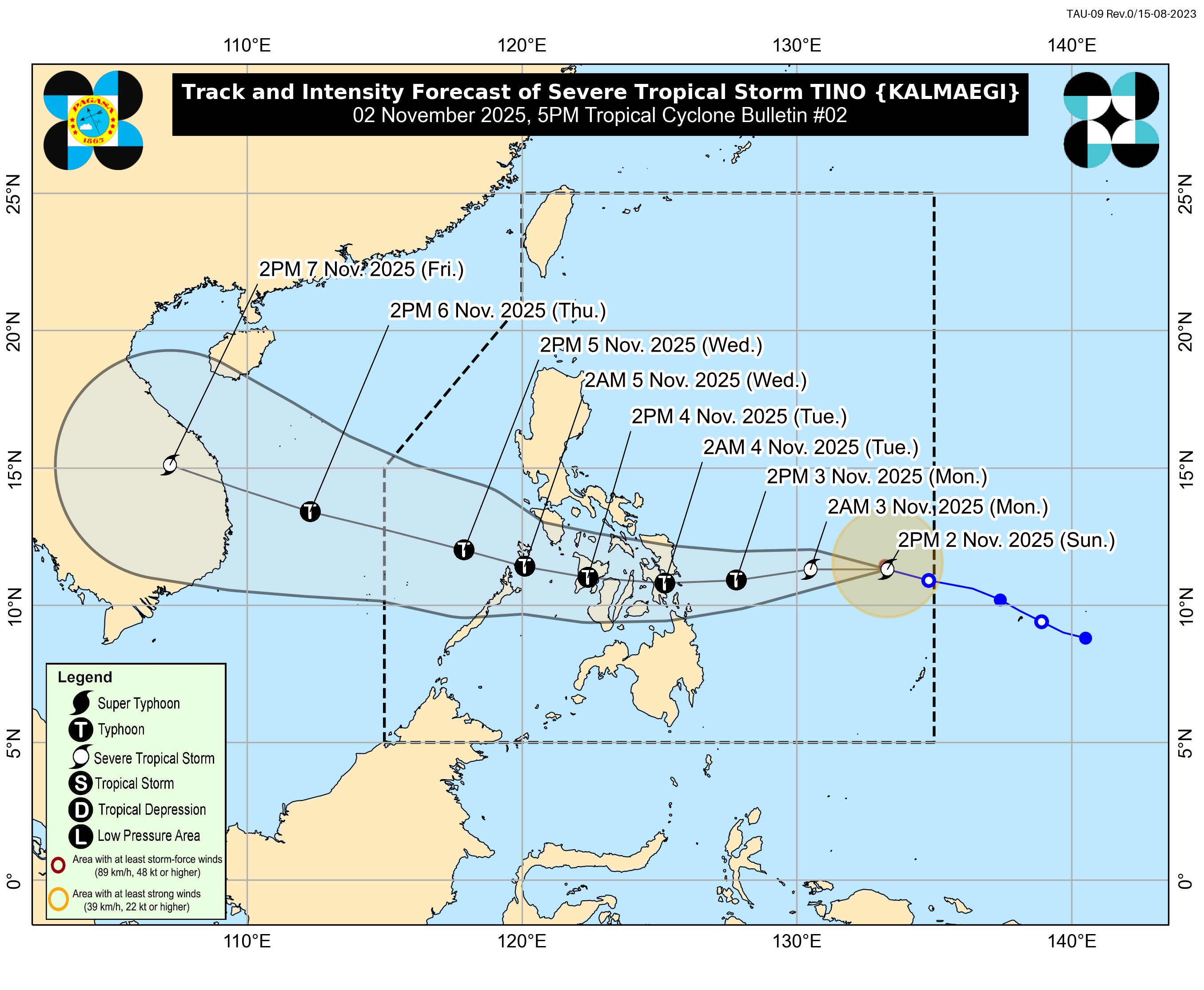
TROPICAL CYCLONE BULLETIN NR. 2
︀︀Severe Tropical Storm #TinoPH (KALMAEGI)
︀︀Issued at 5:00 PM, 02 November 2025
︀︀Valid for broadcast until the next bulletin at 11:00 PM today.
︀︀
︀︀“TINO” INTENSIFIES INTO A SEVERE TROPICAL STORM WHILE OVER THE PHILIPPINE SEA
︀︀
︀︀Link: tinyurl.com/TCB-TinoPH


wew
31W KALMAEGI 251103 0000 10.5N 128.9E WPAC 70 985

stay safe
pagasa has sty forecast for their first cone of the next storm
🥲
TROPICAL CYCLONE ADVISORY NR. 1
Tropical Depression
Issued at 11:00 AM, 04 November 2025
Valid for broadcast until the next bulletin at 11:00 PM today.
THE LOW PRESSURE AREA SOUTH OF GUAM OUTSIDE THE PHILIPPINE AREA OF RESPONSIBILITY (PAR) DEVELOPS INTO A TROPICAL DEPRESSION

fan fucking tastic
ah fuck

easily doable

the 👁️ is here
WTPQ51 RJTD 051800
RSMC TROPICAL CYCLONE ADVISORY
NAME TS 2526 FUNG-WONG (2526) UPGRADED FROM TD
ANALYSIS
PSTN 051800UTC 10.2N 142.1E FAIR
MOVE NNW 11KT
PRES 998HPA
MXWD 035KT
GUST 050KT
its here.

also damn


blob
actually that storm might impact me too
even if thailand doesnt get hit by storms
maybe remnants yeah

mhm
32W FUNG-WONG 251107 1200 11.9N 135.6E WPAC 65 983

the chonker is chonking
(please prepare if you need to)
thats a big motherfucker
that goes straight to my place
another hell week, another eyewall witnessing
it's gonna be a big eyewall 😭

hope i can handle those winds
i'm gonna be outside and document the battering if possible
stay safe and please prepare
dont
well dont do that when the typhoon is there
i mean
stay safe everyone
^also this

i'll be at my balcony
surely i won't be pulled away by the wind
bro a chaser
near


since typhoon matmo


that eye is crazy