#Meteorology
1 messages · Page 10 of 1
Finished

#Beryl's eyewall replacement cycle is evolving quickly tonight as its outer eyewall quickly becomes dominant on both radar and aircraft data. The most recent penetration into the core shows it to be significantly broader, with the secondary eyewall as strong as the primary.
wtf


😭🙏
tbf tropics are just
Dead
except natl
yea
😭
june storm 
oh yeah
tropical storm chris formed
oh wait
it already made landfall
Oh.

O h.
brown ocean 
nah it formed before landfall
think it had a grand total of 12 hours as a ts
LMAO
maybe less
what being an early storm does to a mf

quite literally


...EXTREMELY DANGEROUS EYEWALL OF BERYL MOVING OVER CARRIACOU
ISLAND...
...LIFE-THREATENING WINDS AND DANGEROUS STORM SURGE CONDITIONS ARE
OCCURRING...
SUMMARY OF 1100 AM AST...1500 UTC...INFORMATION
LOCATION...12.4N 61.3W
ABOUT 35 MI...55 KM NE OF GRENADA
ABOUT 15 MI...25 KM ESE OF CARRIACOU ISLAND
MAXIMUM SUSTAINED WINDS...140 MPH...220 KM/H
PRESENT MOVEMENT...WNW OR 285 DEGREES AT 20 MPH...31 KM/H
MINIMUM CENTRAL PRESSURE...956 MB...28.23 INCHES
@tribal arch @normal frost
also added context

bro thinks its emily
bro think hes emily
update?
BECAUSE RECON JUST FOUND 149 KTS SFMR????????
HUH
132kt FL 149kt SFMR 950.7mb
source?
lol

@normal frost here
apparently inflated due to rain spike?
is what others are saying
but still supports 125 to 130 kts
which is uh
Wild
remind me what month it is again?

@normal frost @tribal arch HOLY SHIT THEY PULLED THE 130 KTS TRIGGER
...EXTREMELY DANGEROUS CATEGORY 4 BERYL MAKES LANDFALL ON CARRIACOU
ISLAND...
...AIR FORCE RECONNAISSANCE AIRCRAFT FINDS BERYL STRONGER...
Satellite imagery and Barbados radar data indicate that the eye of
Beryl has made landfall on Carriacou Island at 1110 AM AST (1510
UTC). Data from an Air Force Reserve Hurricane Hunter aircraft
indicate that Beryl's maximum sustained winds have increased to 150
mph (240 km/h). The latest minimum central pressure estimated from
reconnaissance data is 950 mb (28.05 inches).
SUMMARY OF 1110 AM AST...1510 UTC...INFORMATION
LOCATION...12.5N 61.5W
ABOUT 0 MI...0 KM S OF CARRIACOU ISLAND
ABOUT 30 MI...50 KM NNE OF GRENADA
MAXIMUM SUSTAINED WINDS...150 MPH...240 KM/H
PRESENT MOVEMENT...WNW OR 285 DEGREES AT 20 MPH...31 KM/H
MINIMUM CENTRAL PRESSURE...950 MB...28.05 INCHES
????????????
JULY 1.
WTF
130 kn is crazy ☠️
and we might actually be getting c5
IN JULY
??????????????

TCU issued by NWS AT2 at 01 Jul 2024 17:00 UTC
130kts/946

@normal frost @tribal arch no way
recon left
💀
next recon in 6 hours
istg
we're gonna miss its peak arent we
NOOOOOOOOOOOOOO

yea that looks about right
lmao sfmrs broken @normal frost @tribal arch
in the new recon plane
or at least not transmitting

needs 152 kt fl winds for c5 or bust
LMFAO THEY FOUND 151
also 937mb

C5 OR NOT DEBATES IN JULY
WE LIVE IN A SOCIETY
but yeah its 135 kts at minimum
oh sfmrs back?
Woie

sonde
...NOAA HURRICANE HUNTERS FIND BERYL EVEN STRONGER AS IT MOVES
QUICKLY ACROSS THE SOUTHEASTERN CARIBBEAN...
...HURRICANE WARNING ISSUED FOR JAMAICA...
SUMMARY OF 800 PM AST...0000 UTC...INFORMATION
LOCATION...13.4N 64.0W
ABOUT 575 MI...925 KM ESE OF ISLA BEATA DOMINICAN REPUBLIC
ABOUT 910 MI...1460 KM ESE OF KINGSTON JAMAICA
MAXIMUM SUSTAINED WINDS...155 MPH...250 KM/H
PRESENT MOVEMENT...WNW OR 290 DEGREES AT 21 MPH...33 KM/H
MINIMUM CENTRAL PRESSURE...938 MB...27.70 INCHES
THE FUNNY
THEY FOUND 157 KTS FL
wait no shot


...BERYL BECOMES A POTENTIALLY CATASTROPHIC CATEGORY 5 HURRICANE
IN THE EASTERN CARIBBEAN...
...EXPECTED TO BRING LIFE-THREATENING WINDS AND STORM SURGE TO
JAMAICA LATER THIS WEEK...
SUMMARY OF 1100 PM AST...0300 UTC...INFORMATION
LOCATION...13.8N 64.9W
ABOUT 510 MI...825 KM ESE OF ISLA BEATA DOMINICAN REPUBLIC
ABOUT 840 MI...1355 KM ESE OF KINGSTON JAMAICA
MAXIMUM SUSTAINED WINDS...160 MPH...260 KM/H
PRESENT MOVEMENT...WNW OR 290 DEGREES AT 22 MPH...35 KM/H
MINIMUM CENTRAL PRESSURE...938 MB...27.70 INCHES
i cannot sleep
anyways here another record broken @tribal arch @normal frost
das crazy
oh my fucking god
july btw.
bro spawned and chose violence
...CATEGORY 5 BERYL STILL INTENSIFYING IN THE SOUTHEASTERN
CARIBBEAN...
...EXPECTED TO BRING LIFE-THREATENING WINDS AND STORM SURGE TO
JAMAICA LATER THIS WEEK...
SUMMARY OF 200 AM AST...0600 UTC...INFORMATION
LOCATION...14.2N 65.8W
ABOUT 445 MI...715 KM ESE OF ISLA BEATA DOMINICAN REPUBLIC
ABOUT 775 MI...1245 KM ESE OF KINGSTON JAMAICA
MAXIMUM SUSTAINED WINDS...165 MPH...270 KM/H
PRESENT MOVEMENT...WNW OR 290 DEGREES AT 22 MPH...35 KM/H
MINIMUM CENTRAL PRESSURE...935 MB...27.61 INCHES
@normal frost @tribal arch 145 kts?????

💀 💀 💀 💀 💀
holy moly
ok seems to have peaked

164kt FLW 165kt SFMR
@tribal arch @normal frost
?
???????????????????????????
hey so
thats
Kind Of
150 to 155 kts support.

this storm isnt real man
JULY BTW
JULYYYYYYYYYYy
ok seems to be weakening
recent recon now showing like
150kt FLW 148kt SFMR
still tho crazy that we even got This in the first place
bro thinks its a wpac storm
LMAO
anyways 96L prolly busted hard
down to 20/30
...BERYL EXPECTED TO BRING LIFE-THREATENING WINDS AND STORM SURGE
TO JAMAICA ON WEDNESDAY...
...HURRICANE HUNTER AIRCRAFT REPORT LITTLE CHANGE IN STRENGTH OVER
THE PAST FEW HOURS...
SUMMARY OF 800 AM AST...1200 UTC...INFORMATION
LOCATION...15.0N 67.9W
ABOUT 300 MI...485 KM SE OF ISLA BEATA DOMINICAN REPUBLIC
ABOUT 625 MI...1005 KM ESE OF KINGSTON JAMAICA
MAXIMUM SUSTAINED WINDS...165 MPH...270 KM/H
PRESENT MOVEMENT...WNW OR 290 DEGREES AT 22 MPH...35 KM/H
MINIMUM CENTRAL PRESSURE...934 MB...27.58 INCHES
oh wtf
alright then
,
prolly in reanalysis i guess
shear starting to really get to it
unfortunately its probably still gonna hit jamaica as a major

World Meteorological Organization
A WMO international committee of experts working under the auspices of the Weather and Climate Extremes Archive conducted a detailed analysis and verification of the distance and duration. The evaluation committee recognized Tropical Cyclone (TC) Freddy’s duration of 36.0 days at tropical storm status or higher as the new world record for the lo...
@normal frost
its official


thats gonna be a scary flood potential

yea 120kt is still fucked
I hope they dont get landslided to hell
jamaica is especially prone

oh god
its down to c2 tho
okay correction, I can't actually count https://vxtwitter.com/philklotzbach/status/1808923377836441810?t=vjYpqmLkS8WY4tLwpYIeug&s=19

#HurricaneBeryl has finally weakened to a Category 2 #hurricane. #Beryl was a major (Category 3+) hurricane for 4.25 days, tied with Hurricane Emily (2005) for the most major hurricane days produced by a sin…
💖 113 🔁 44
this motherfucker better not pull a harvey
atp it depends
the more north it gets
i believe stronger ensemble members have it going more north
weaker ones have it doing a double mexico landfall
anyways
epac got a named storm
prolly wont last long tho
classic first storm flop

wtf why is it still doing that
bro really woke up and said "im gonna carry this season's ACE"
...BERYL WEAKENING AS IT MOVES FARTHER INLAND OVER THE
NORTHEASTERN YUCATAN PENINSULA...
...DANGEROUS HURRICANE-FORCE WINDS, STORM SURGE, AND DAMAGING WAVES
EXPECTED OVER PORTIONS OF THIS AREA FOR A FEW MORE HOURS...
SUMMARY OF 1000 AM CDT...1500 UTC...INFORMATION
LOCATION...20.7N 88.3W
ABOUT 100 MI...160 KM ESE OF PROGRESO MEXICO
ABOUT 680 MI...1095 KM ESE OF BROWNSVILLE TEXAS
MAXIMUM SUSTAINED WINDS...85 MPH...140 KM/H
PRESENT MOVEMENT...WNW OR 290 DEGREES AT 16 MPH...26 KM/H
MINIMUM CENTRAL PRESSURE...980 MB...28.94 INCHES

TCD issued by NWS AT2 at 05 Jul 2024 15:00 UTC
funny you say that
if it heads north to like new orleans we could be seeing another RI

damn i thought nio was insane for 700%
guess not
other than beryl very depressing so far
global at 73% of normal ytd
yeah wpac is
gonna be interesting (and scary)
one of the very few years where there are zero june storms
yet yknow whats another year without a june storm?
2016 💀
foreshadowing?
who knows
we're headed into either a cold neutral or a la nina
and we also have -pdo
yea it's gonna be an inactive year
odds are pretty stacked against wpac
its not that flop
bro popped off before peak season only to Not Do Anything After
tru
but Man
i thought we'd finally get an above average season
even if its just ace wise
😔

what
rai as in
the 2021 storm
tbf we had bangers last year
mawar, bolaven, saola
tho only bolaven was fish
i forgor bout oceania,,
was surprised too ngl
😔
been downhill since 2019

ngl didnt realize but Lan was pretty picturesque at peak
oh wow

got gregged
sob
💀💀💀💀💀
beryl down to TS strength
😔


oh gawd

"almost"
what
💀💀💀💀
hwrf moment
good thing its not gonna verify this time around
oh wtf
BoM used SAR again to upgrade another storm
this time its jasper from aus c4 to aus c5 LOL
poggeres !!


😩😩😩😩


its getting the northeastern side of the storm its joever

one hell of a start

a

Louie
here it comes
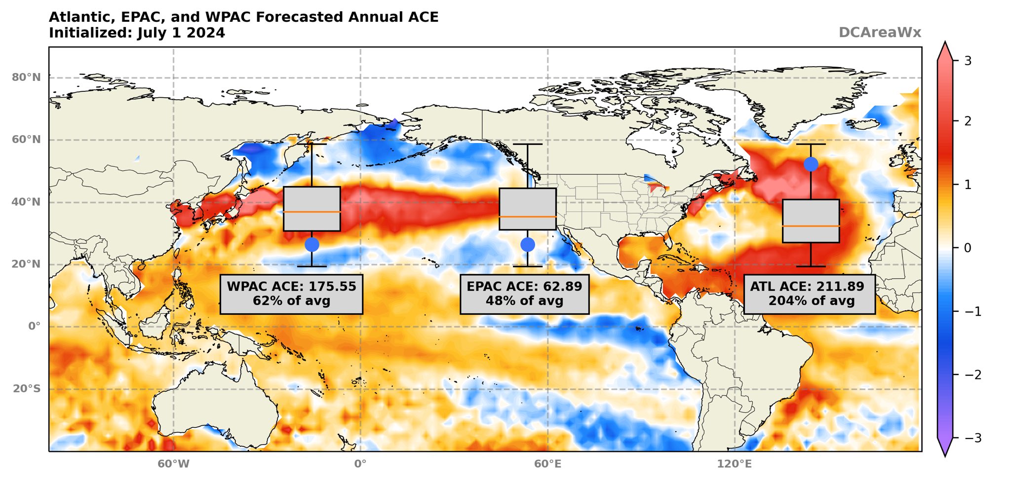
Here are the results of the July run of ACE Predictor thing. The Atlantic forecast for annual ACE increased a bit thanks to Beryl, while the Pacific basins continue to look very quiet. This has been very consistent so we’ll see how well it performs.
pacific bros its so over
tornado in lithuania!!!!
it was kinda close to me (but not close enough)
in general the weather was p shitty yesterday
supercell taken on that day

ill post the vids once i figure out how to download them from facebook
grah
formation and someone's house getting hit
two people injured, no deaths
most of our country is farmlands lmao
rare but they're getting more common
https://www.google.com/maps/place/55°42'00.0"N+23°10'19.2"E/@55.6969653,23.1498287,5346m/data=!3m1!1e3!4m4!3m3!8m2!3d55.7!4d23.172?hl=lt&entry=ttu formed near this village

55°42'00.0"N 23°10'19.2"E · Kiaunoriai, Kelmės r. sav., Lietuva
Kiaunoriai, Kelmės r. sav., Lietuva
i doubt there's gonna be much more info shared
nada
unfort
happened two hours ago so we'll have to wait
now could the next one be a tad closer to me?
dont jinx it
thats massive


but like
I doubt it'd actually slab shianghai
prob will go to korea
or just under shianghai
i cant look at models atm im fuckin formatting windows


uh oh
tropics update!!!
04w, 05w both formed; both forecasted to make landfall in china
04w is SCS slop
05w is named now, Gaemi
both also have par names but that doesnt rly matter
also 93w exists but idk if it'll be a surprise storm formation or just go poof
on the other side of the pacific invests keep dropping dead 🔥🔥🔥 this epac season is so doomed 🔥🔥🔥🔥🔥

@normal frost @tribal arch
also here's epac if you wanna see a burning dumpster fire

epac...


bruh
guess its just 04w and 05w
well that answers it


mayhaps
ok wow


we have prapiroon @normal frost @tribal arch
hko has 40kts
10-min
for gaemi, jtwc just went 50kts
1-min

yikes


im getting rained on rn 🗿
💀


oh wtf
why is this fucker intensifying and the obvious storm dying


let it cook

☠️
what the fuck


@normal frost @tribal arch bros...
also when was the last time we had a typhoon in the gulf of tonkin lol
goof
anyways
gaemi now typhoon
prapiroon probably typhoon but no one has pulled the trigger yet
closest is cma at 60kts?

what

anyways both jma and jtwc have 60 kts on prapiroon
jma try not to underestimate storms challenge
(impossible)

no i mean
severe overestimate for gaemi
LMAO

🗿🗿🗿

75kts is like

ok thats dumb LOL
we live in a society

that shit does not look 70 lol
lmao
we'll see

Reddit
Explore this post and more from the VirtualYoutubers community
@normal frost bro What.
❓❓❓❓

monsoon :D
😭
05W GAEMI 240723 0600 20.6N 125.0E WPAC 90 959
bruh i got home a little late because of the fuggin storm
even with my raincoat
i still got drenched
gg


@normal frost @tribal arch 125kts
05W GAEMI 240724 0600 24.2N 122.5E WPAC 125 919


BREAKING: #CarinaPH (#Gaemi) is now a SUPER TYPHOON by @dost_pagasa, with 10-min sustained winds of 185 km/h and gusting to 230 km/h.
It is the first STY within the Philippine Area of Responsibility (PAR) this year, and the first since STY #GoringPH (#Saola) in 2023.
pagasa STY
cwa also went 140kts i think
jma at 90kts koba (i think thats 110 1-min?)
WTF

bro did a bmw 💀💀💀
landfall.
what 🗿
yeah epac is literally record low activity rn
holy shit

XDDD
wtf maria returns
yea the wpac maria
we have one for some reason
¯_(ツ)_/¯
the last wpac maria (2018) was a c5
Hell yeah

here
both mawar and bolaven up to 165kts
still kinda crazy we had this much majors last year ngl
lets gooo
at least something interesting is happening in america
2 EF4s in one day
well 1 but 2nd one got upgraded today
damn
🥶🥶🥶
https://cdn.discordapp.com/emojis/1024752013491322901.gif?quality=lossless&name=RonaldoSipping&size=

carlotta seems to have peaked
90 mph
ts daniel formed in epac
short lived prolly
04L is a thing now

interesting feature
kinda sad that no one would designate it even if it formed tho

round of applause for epac finally doing something
that's natl man
sry to break ur bubble
unfortunately yeah
it aint the case
its ok we're up to emilia now
for epac
fabio soon
omg emilia the osu player retired to become a storm

TeamDomHQ Discord - https://discord.gg/teamdomhq - First week or so for Channel Members onlyWant to be a Member? Click here : https://www.youtube.com/channel...
hunting tornadoes in a hurricane
sick af
the question of if he will actually intercept one is another story
but yes they can happen
oooh


life could be dream
🗣️🗣️🗣️🗣️🗣️🗣️

tweaking
let it cook
thats a funky cone on maria
oh wait it updated
last one had it turn a hard 90 degrees to japan
think it still tries to
WTPQ51 RJTD 110900
RSMC TROPICAL CYCLONE ADVISORY
NAME TS 2406 SON-TINH (2406) UPGRADED FROM TD
ANALYSIS
PSTN 110900UTC 28.4N 155.2E FAIR
MOVE N 09KT
PRES 994HPA
MXWD 035KT
GUST 050KT
30KT 180NM EAST 60NM WEST
@tribal arch @normal frost
stc jumpscare
formed from 95w


woa

that'd be fine
if
it actually formed yknow
💀
apparently tho it has a good shot of forming soon
just a reminder that is the same system as this one @normal frost


actually fkin crazy
imagine if it had more time
💀
07W SON-TINH 240812 0600 32.4N 151.5E WPAC 40 992
bro its finally tropical @normal frost
LMAO

3 TCs
https://cdn.discordapp.com/emojis/1024752013491322901.gif?quality=lossless&name=RonaldoSipping&size=
08W EIGHT 240812 1200 23.6N 136.7E WPAC 25 999

?
my god its been reborn
i have a weird feeling its gonna get sheared first tho
and then be a fish storm

are u still sure
tho it has shear to deal with so yea ur right
RSMC TROPICAL CYCLONE ADVISORY
NAME  TS 2407 AMPIL (2407) UPGRADED FROM TD
ANALYSIS
PSTN  121800UTC 23.7N 136.8E FAIR
MOVE  NNE SLOWLY
PRES  998HPA
MXWD  035KT
GUST  050KT
30KT 120NM EAST 90NM WEST```fresh off the oven @normal frost @tribal arch
we are now sitting at 7/2/1
should rly be 7/4/1 but kek

could also see a surprise storm from this one ngl
le invest

like a pan de sal at 4am 🗣️🗣️🗣️
🔥🔥🔥

RSMC TROPICAL CYCLONE ADVISORY
NAME  STS 2407 AMPIL (2407) UPGRADED FROM TS
ANALYSIS
PSTN  130600UTC 24.6N 138.7E FAIR
MOVE  ENE 10KT
PRES  990HPA
MXWD  050KT
GUST  070KT
30KT 120NM EAST 90NM WEST```@tribal arch @normal frost oh?
that was fast
theyre now forecasting 80 kts koba

bro rly thinks its neuville
RSMC TROPICAL CYCLONE ADVISORY

NAME  TS 2408 WUKONG (2408) UPGRADED FROM TD

ANALYSIS

PSTN  130600UTC 26.3N 150.5E FAIR

MOVE  ENE SLOWLY

PRES  1004HPA

MXWD  035KT

GUST  050KT

30KT  90NM EAST 60NM WEST

FORECAST

24HF  140600UTC 31.7N 148.1E 35NM 70%

MOVE  N 12KT

PRES  1002HPA

MXWD  035KT

GUST  050KT

48HF 150600UTC 38.5N 148.5E 55NM 70% TROPICAL DEPRESSION =```jumpscare ts @tribal arch @normal frost

LMAO

what the fuck

🔥🔥🔥🔥🔥🔥

@tribal arch @normal frost
yea thats booming
track shifted further away from tokyo tho which is nice
woa
🙏


thats definitely at least mid c3 LOL
08W AMPIL 240815 1800 32.5N 140.8E WPAC 100 951
2nd major
of this year's wpac
or 3rd if u think ewiniar was major
anyways moving to NATL

what the fuck is this.
woah

ok damn
honestly that is such a large ass eye
wouldnt it be funny if it reaches c4 at tokyo latitude @normal frost
remember when
we thought tokage was rare as fuck for intensifying into a major at japan latitude
well here we have a storm doing the same thing but stronger 💀
yeah it does
good thing it trended east
fish storm!!!!
08W AMPIL 240816 0000 33.5N 140.8E WPAC 115 947
wait yo? @normal frost

not sure if c4 is justified but
hey
34N c4 💀💀💀

it can swallow half the country
meanwhile that one Japanese streamer

💀💀
so we got a new named TS @normal frost
did a funni tc jumpscare earlier
and uh

its not doing so good
o h

what


huh
also has a GW from jma so could be named anytime soon
next name is "Shanshan"
goofy ahh name wtf
lmaoo

we also have this in EPAC @normal frost
2nd hurricane of the season so far
wild that its this late
oh
speak of the devil
Hurricane Gilma Advisory Number 13
NWS National Hurricane Center Miami FL EP072024
800 AM PDT Wed Aug 21 2024
...GILMA INTENSIFYING...
...NOW FORECAST TO BECOME A MAJOR HURRICANE...
SUMMARY OF 800 AM PDT...1500 UTC...INFORMATION
LOCATION...16.0N 122.8W
ABOUT 965 MI...1555 KM WSW OF THE SOUTHERN TIP OF BAJA CALIFORNIA
MAXIMUM SUSTAINED WINDS...85 MPH...140 KM/H
PRESENT MOVEMENT...W OR 280 DEGREES AT 7 MPH...11 KM/H
MINIMUM CENTRAL PRESSURE...983 MB...29.03 INCHES

not even 4 hours
that shit straight up looks like a major already
yeah
hone! hone! hone! hone!
"we have hone at home"


RSMC TROPICAL CYCLONE ADVISORY
NAME  TS 2410 SHANSHAN (2410) UPGRADED FROM TD
ANALYSIS
PSTN  211800UTC 16.7N 142.1E FAIR
MOVE  WNW SLOWLY
PRES  1002HPA
MXWD  035KT
GUST  050KT
30KT 120NM EAST 90NM WEST```ooooh
jma forecasts typhoon as well
minimal tho

tbf the advisory after called for 95
so ig 100 is not surprising
but like
100 there?
really???
💀💀💀💀
bro going straight for it
tbf that was first cone
i forgor to post the next one
LMAO
i didnt check,,

yep just your average 180kt storm at 32N
yk when you think about it
it might actually be possible in like 15 years
fucking global warming
@normal frost 90C INVEST 240822 1200 15.4N 140.3W CPAC 30 1005
so guess who's in CPAC now
01C

SOON
LETS FUCKING GOOOO
@normal frost
CP, 01, 2024082218, , BEST, 0, 157N, 1416W, 35, 1005, TS, 34, NEQ, 15, 0, 0, 15, 1011, 150, 15, 0, 0, C, 0, , 0, 0, HONE, M, 0, , 0, 0, 0, 0, genesis-num, 020,
WELP.
only 2 more hours before it becomes official ig
almost
5
fucking
years.
HONEEEEEEEEEEEEEEEEEEEEEEEEEEE


this actually happened one advisory ago but i was asleep alr lol
@tribal arch @normal frost


YES.
MY GOAT HONE RAHHHHHHHHHH


🗣️🗣️🗣️🗣️🗣️🗣️


🔥
not bad for cpac
not bad

bruh embed fail

uh oh
guess it took offence to the ppl calling it slop earlier in the morning
cuz of dry air intrusion
on the bright side tho track shifted west
no thats not hone
thats shanshan
LMAO
y'know
LMFAO
@normal frost
RSMC TROPICAL CYCLONE ADVISORY
NAME TY 2410 SHANSHAN (2410)
ANALYSIS
PSTN 261200UTC 27.7N 132.0E GOOD
MOVE WNW 06KT
PRES 980HPA
MXWD 065KT
GUST 095KT
50KT 30NM
30KT 210NM NORTHEAST 120NM SOUTHWEST```meanwhile jtwc
11W SHANSHAN 240826 1200 27.8N 131.9E WPAC 90 958
WAIT
@normal frost
UFJENDJENNFNENDMF

Enough, just stop it already…
💖 214 🔁 40
WHY.
@tribal arch


wtf

staying alive

jesus
