#Meteorology
1 messages · Page 2 of 1
💀
man
probably
but im still hoping for c3
bro i just noticed outsiders will think we are talking about genshin LOL
cmonnnn

WA
swio gonna get its 4th named storm then
gonna match aus with that (excluding 01U)
spac still at 2 💀
poge
@normal frost @normal frost @normal frost @proven rain 94S FINALLY FORMED
06S "Dingani" 16.6S 88.9E 998 hPa 21.0 m/s (40 knots)

LETS GOOOOOOOOOOOOOOO
tfw it decided to form right after leaving aus


quirky
gabrielle looks extremely menacing lmao


wtf
@normal frost

😳

gabrielle is now 70kt while freddy is dying at 50kt

75 now
jtwc at least
bom upgraded to c3 aus
12P GABRIELLE 230209 1800 20.7S 156.1E SHEM 75 971
yum
Nice
freddy L
rofl
Oh
zamn
11S FREDDY 230210 1200 14.8S 106.5E SHEM 70 982
12P GABRIELLE 230210 1200 24.8S 162.4E SHEM 75 968
13S DINGANI 230210 1200 16.1S 82.7E SHEM 45 997
90P INVEST 230210 1200 1.0S 149.5E SHEM 20 1004
wait
90P INVEST 230210 1200 1.0S 149.5E SHEM 20 1004
so ur telling me
theres an invest north of new guinea
its actually more confusing why we havent had more
its shem peak season, after all
Better than nothing

holy shit
70 kts peak rn


wait aint no way
freddy 90kt now
major?major?major?

oh dear
thats like
almost 80kt
TROPICAL CYCLONE INFORMATION BULLETIN
Issued at 8:39 pm WST on Saturday 11 February 2023

Severe Tropical Cyclone Freddy (Category 4) was located at 8:00 pm AWST near
14.8S 102.9E, that is 570 km south southwest of Christmas Island and moving
west at 20 kilometres per hour.

Severe Tropical Cyclone Freddy will continue moving westwards across the Indian
Ocean, passing well to the south of the Cocos (Keeling) Islands.

Severe Tropical Cyclone Freddy poses no threat to the Western Australian coast,
Christmas Island or the Cocos (Keeling) Islands.

The next Information Bulletin will be issued at 3:00 am AWST.

yep
1st major
cheneso meme'd itself out of existence
and gabrielle peaked at 90kt
does any of the pinned material actually explain what yall are talking about
😋😋😋
uhhh
welp
@atomic flint yknow when I did meteorology terms
i might have to update that
but nero took away our pin perms
😭😭😭😭😭
nope
do you want the storm glossary?
its....not really friendly either
since in the force 13 server, there's an entire #glossary channel lol
do i post all of them @normal frost
LOL
why tho
but later because i have a headache
i think f13 sums it up well
just remove some stuff that u think arent that important
ap
the thing is
that still doesnt explain anything lol
like we know what it is
other people dont
imma go nap because headache
also pls get nero to give us pin perms again LOL
(or rian)
here @normal frost
pretty surface level stuff
but should be good enough
oh wait
found smth better


o/
gud

cant believe that thing didnt flop

leTS GOOOOOO
what happens when you work at fazbear pizzaria:
its freddy's 5th night too btw
quite fitting LOL
XD
LOL

yea
it got sheared to death
but it still has insane winds tho
that thing is already hitting nz with what
80kt winds
💀💀💀💀
nah no way its 80 lol
its EX
definitely way less

@normal frost this is a track of all time
one of the tracks of all time

oh dear
apparently its still cat2 strength
wait pressure or wind

dingani popping off
@atomic flint
The Channel Island wind observation in the Gulf is recording sustained winds of 124 km/h (67 knots), gusting to 146 km/h (79 knots). In the tropics sustained winds from 118–157 km/h is category 3 status.

welllllllllllllllllllllllllllll
by cat 3 they meant aus scale 💀

but yeah 65 kt seems accurate
cape reinga currently has 985 hPa
i mean i was almost right
i said 80kt earlier
and well its 79kt

💀💀💀💀💀💀

👀
also jtwc's pgtw fixed a 3.5 on this LOL
lets hope the dry air doesnt choke it to death before then
idk honestly
thing's already overperformed
any more is just icing on the cake
truee
wait its heading south now FUCK
at about 25S
theres strong shear
30-40kt
yeah its supposed to get sheared to death after reaching peak
lemme slap it
still a bit til then tho
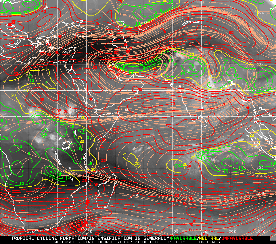
shear at freddy is 25 kt?
apparently
||i mean there's the saying that shear maps are unreliable but eh||
dingani is what
sub 15?
lol

hoho
tfw there's 2 banger storms rn but few ppl in f13 are tracking them
o
natl sleeping
lmfao
what site even is that
a
🤨
yea its there
epac waking up?
WAIT WHY IS IT SHOWING OLD SHIT LOL
that shit is outdated af
YEA I CLICKED ON IT
AND IT SHOWED BONNIE IM LIKE??????????
thats so weird
wow i cant believe ap is trolling
i was using it earlier and i got dingani
proof
also holy fuck thats a long link
bro my chairs started floating halfway through that link
o
press storm name -> click gcom-w-1 -> click color (under asmr2)
...or you dont need to click on gcom????? im so confused rn
wtf is this site
zamn
honestly im just waiting for mfr 18z so i can go sleep LOL

thing's really trying but its time is ticking
don't think it'll make it to major anymore
AWA
11S FREDDY 230212 1800 15.0S 97.9E SHEM 100 948
12P GABRIELLE 230212 1800 33.3S 175.3E SHEM 55 982
13S DINGANI 230212 1800 17.8S 74.4E SHEM 75 981
freddy weakening now
yeah

ho


WOI
also this has to be one of the Tracks of all time
true...
but wow
imagine
the tc breakout was actually successful
c4 in aus and double c2s in the other 2 basins
mmmmm
also like
freddy having a THIRD peak?
in like 3 days
at least jtwc says so

im ngl

my guess is that it will go a bit more south
and it'll live for a while more
pls live 2 weeks it will be funny
NOOOOOOOOO

let him cook
11S FREDDY 230215 0000 15.3S 87.3E SHEM 120 942
12P GABRIELLE 230214 1800 38.5S 178.5W SHEM 30 1000
13S DINGANI 230215 0000 25.3S 71.0E SHEM 50 989
91P INVEST 230215 0000 15.1S 140.4E SHEM 25 1000
99W INVEST 230215 0000 5.2N 134.7E WPAC 20 1007
ayo wpac invest?
🤨

dingani basically EX at this point
freddy got about 16 hours to strengthen before it gets into worse conditions
mfr went ex already no?
jtwc fixed t7.0, sab t6.5, mfr t6.5
also imd t7
oh yea jtwc went 130kts, mfr 115kts 10-min (just shy of vitc)

never!!

@normal frost @proven rain
that wpac invest might have a good chance

mjo in phase 6
pogeeee
even if not, la nina's basically a goner so good enough


"Passenger photo while plane flew near East Palestine, Ohio ... chemical fire after train derailed"
looks safe
jesus
cat5!cat5!cat5!

@proven rain @normal frost cockblocked
11S FREDDY 230215 1200 15.0S 84.9E SHEM 135 932
135
when the c5n't
Let Freddy cook more
let him cook
@normal frost @proven rain nvm
[Override]
11S FREDDY 230216 1200 15.0S 79.5E SHEM 125 939
11S FREDDY 230216 0000 14.8S 82.3E SHEM 145 918
11S FREDDY 230215 1800 14.8S 83.6E SHEM 140 923

aw
we're getting hit!!!!!
basically i live close ish to the coast
so we might have 25 m/s winds
stay safe hun
stay safe


The catastrophic blizzards of 1977 and 1978 occurred amidst record-breaking cold spells that affected the entire country. Today we look at these blizzards in detail, learn the meteorology behind them, and examine some of the incredible stories to emerge from the wreckage.
Sources and further reading: https://controlc.com/3ed29434
Chapters:
0:...
this video got me so interested in jet streams LOL

impressive eye

LOL
I’m sorry but it’s unacceptable. Completely unacceptable. There’s no satellite resolution issues, there’s not a fluctuation of eye temp, there’s not only a few pixels, there’s not a small eye. There’s not. This is straight up either unskilled analysis or rigging. No way around it


TRUE
11S FREDDY 230217 1200 15.8S 74.0E SHEM 120 944
woah
he knows how to atcf
fingers crossed that gets overrided, no way in hell this shit is only 120 kts lol

Dang
yeah
@proven rain @normal frost https://twitter.com/VortixWx/status/1627107519192797184?t=4w3cUWDAt28hO1DOFH9ciw&s=19
Not JTWC but:
#BREAKING:
#Freddy is now a Very Intense Tropical Cyclone at this time & will remain that way for a while.
This marks the 1st season to have 2 MFR VITCs since 2014-15
And the 3rd VITC in February on record (Gervaise ‘75 & Faraji ‘21 were the other 2) #tropicswx


holy shit thats scary
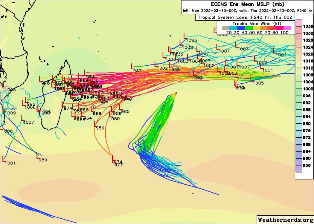
If the JTWC forecast were to verify exactly as they predict, #Freddy will reach 70.5 ACE units while still having around 1 day left over water, and 2 days left as a TC in its lifetime. You can track your whole life and see maybe 3-4 70+ ACE storms. They’re more rare than 170kt+


The hurricane of 87
freddy (real)

what a menace
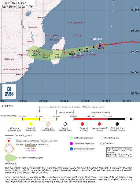
now if only it wasnt on a crash course to Madagascar
@atomic flint i agree with ur username
oh dear god
yes!!!!
06z has freddy maintaining 120 kts 10-min
but weakening expected in 6 hrs
although....
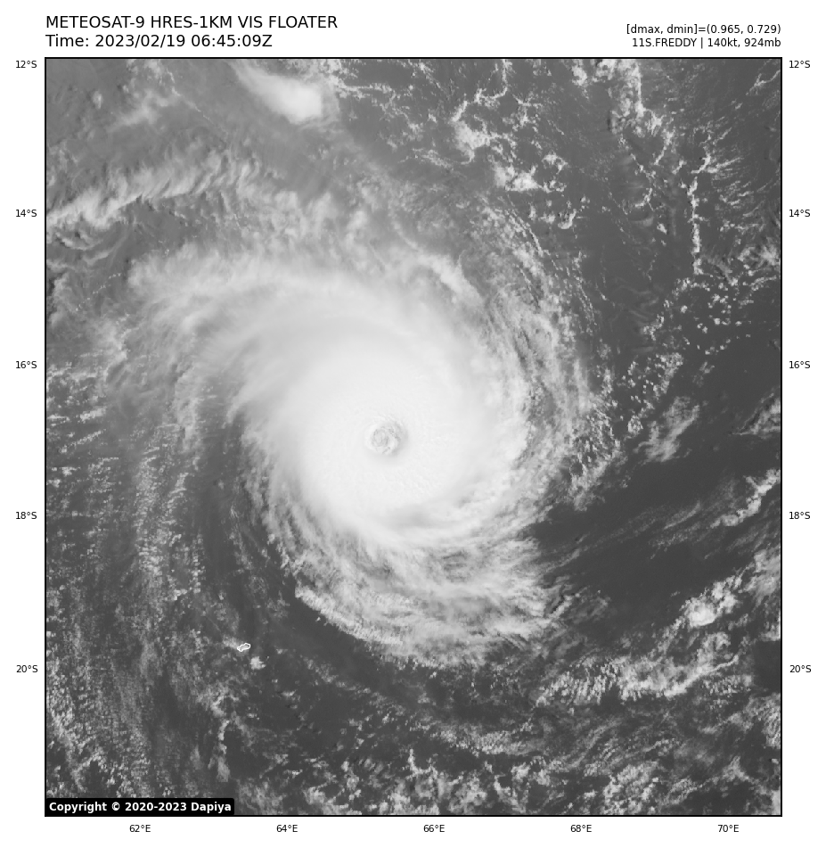
11S FREDDY 230219 0600 17.0S 65.7E SHEM 140 924
fantala's ace record is down

This feels like a narration of a race lol
until you realize its threatening a country of 30 million

and another one with 31 million right after


#Freddy became the highest ACE storm in the southern hemisphere at 06Z Feb 19, with 53.8125 points. Breaking the record set by 2016 Fantala at 52.4725.
And Freddy's journey isn't ending yet...
It's possible that Freddy can become officially the second highest ace storm.


btw @normal frost @proven rain
next on the list is fengshen (tho unofficially that thing has 76 ace LOL)
Rip
nah
ivan 2004 had higher
i think its barely over 70 ace
oh what
apparently theres a hurricane in 1899 with even higher ace
@atomic flint

ikr


jesus fuck
also @atomic flint i just saw the pin
are you doing updates like f13
or different
idk
💀
i guess lets just pin meteo france cones?
sure
11S FREDDY 230219 0600 17.0S 65.7E SHEM 140 924
92S INVEST 230219 0600 11.8S 114.7E SHEM 15 1010
93S INVEST 230219 0600 10.1S 90.2E SHEM 20 1007
99W INVEST 230219 0600 12.9N 123.2E WPAC 20 1004
still going strong
💪
ye
freddy + 3 shitty invests
lets see if it maintains in 12z
imma be real i have no idea what that means
warm medium gray
a
dvorak thing
i havent learned dvorak,,,
only know it cuz of this
apparently dingani played a part in this
ig it did throw some dryness out of the way for freddy?

ap,,,
tldr; dingani's upper level outflow pushed air to the subtropical ridge (H) making whatever air in the path of freddy have lower pressure overall (I was also partially right that it pulls some dryness away)
well in other words
the dry subtropical ridge that was sending dry winds via trade winds got disrupted by dingani
so freddy gets a free pass
oh damn
oh wow freddy actually got no shear in its way at all
dapiya is up
fuk

@atomic flint maybe this is why freddy is forecasted to weaken

look whats infront of it
yea


yeah
thanks freddy
yea but nhc is blind
a
ok now the only thing freddy has to do to make it a super funny storm
is that it stalls in the channel

can you NoT
when the cheneso
oh wait

nvm i forgor hale, irene, and hannelore existed
the first 2 are too forgettable 💀
mediterranean storm
Oh
hale -> slop spac
irene -> slop spac (2) that built an inner core
when the south pacific slop
kekw
yknow looking now
climate change is super obvious when I look at ACE stats for each year
I will screenshot some random 10 years before 1950 and another random years after 1950 and chances are it will have much more ACE on average
example


1930's vs 1960's
u sure
you gotta take into account that pre satellite era seasons are kinda yikes
a lot of missed tcs and all that
probs better to compare smth like 1970s and 2010s
^
aight
since 1970s had wpac recon


let me see
wait why is 1973 inactive when wpac was also gunga inactive then
lol
anyways 1971 had 35 wpac tropical storms
lol.
wait 24 typhoons?????
why does 1972 also have the same amount of typhoons with only 31 storms???????????

tho iirc 2015 should have the highest ace
o

wao
wanna make a guess on what year had the most retired names
lets start with wpac
like literally right before you said it
'19 and '20 had 5 each
lemme check if there's more
'06 had 5 as well
😠
oh
1960 had 8.........?
1950
i mean
Names decommissioned
For unknown reasons, the names Helene, Jane, Kezia, Lucretia, Missatha, Ossia, Petie, Salome and Delilah were replaced with Helen, June, Kathy, Lorna, Marie, Olga, Pamela, Sally and Dot.
oh 1949 had 9
ha?
confusing ass namechanges
if you go with jtwc list and are ok with ancient shit, yea 1949 had 9
if you go with post 2000, then 5
o
if you go with 1970 - 2000
surprisingly the most was 2
because a typhoon causing 225k deaths wasnt eligible for retirement
😇
nina 1975
ha?
ye
banqiao dam failure
but for what its worth
In 1980s, several representatives of the Chinese People's Political Consultative Conference including Qiao Peixin (乔培新), Sun Yueqi (孙越崎), Lin Hua (林华), Qian Jiaju (千家驹), Wang Xingrang (王兴让), Lei Tianjue (雷天觉), Xu Chi (徐驰) and Lu Qinkan (陆钦侃) revealed that the death toll of the 1975 Banqiao Dam failure was 230,000.
storm committed a genocide bruhh
Bhola v2
jesus what
yeah
155 mph, weakened to a c3 upon landfall in taiwan
a grand total of 29 of nina's deaths were from taiwan

yeah
i mean if 64 inches of rain falls down into a poorly made dam
shit happens
33 inches of those fell in 6 hours btw
y ea
💀
11S FREDDY 230219 1200 17.4S 64.1E SHEM 140 918
?
why 918
it was 140/924 before
"yes"


eh
maintaining
or even strengthening?
yikes
also like why cant i find this
Rate it now

i grab it off f13 but its dapiya -> ir ott
!!!!!
wejj

11S FREDDY 230219 1200 17.4S 64.1E SHEM 130 934
expected
tho ngl 135-140 is probably better anyway
that looks sexy hoyl


the wejj,,,,
in ace at least
@normal frost holy shit dude

freddy just completely collapsed
😭
WTF
when u use himawari in swio
true,,,
lmfao we're still the thread with the highest messages
lol
also
tfw someone mentioned in #1072081241257562192 that #1072081241257562192 passed this thread in messages earlier today
and this thread took it back again

Over the past 6 hours, the cloud tops of Tropical Cyclone Freddy have warmed up causing a decrease in intensity according to subjective analysis. However, th...
@normal frost
zamn

A. TROPICAL CYCLONE 11S (FREDDY)

B. 19/1730Z

C. 17.56S

D. 62.45E

E. ONE/MET9

F. T7.0/7.0/D1.0/24HRS  STT: S0.0/03HRS

G. IR/EIR

H. REMARKS: 01A/PBO EYE/ANMTN. WMG EYE SURROUNDED BY W YIELDS AN E#
OF 6.0. ADDED 1.0 EYE ADJUSTMENT FOR W, TO YIELD A DT OF 7.0. MET
AND PT AGREE. DBO DT.

I. ADDITIONAL POSITIONS:
   19/1200Z  17.33S  63.97E  SSMS
   19/1327Z  17.43S  63.62E  GPMI


HUYNH```TCSSIO
A. 11S (FREDDY)
B. 19/1730Z
C. 17.6S
D. 62.5E
E. ONE/MET-9
F. T6.5/6.5
G. IR/EIR/SWIR
H. REMARKS...LARGE STADIUM-EFFECT WMG EYE SURROUNDED BY W AND EMBEDDED
IN B RESULTS IN AN E# OF 5.5 WITH EADJ +1.0 FOR A DT OF 6.5. OUTSTANDING
SATELLITE PRESETATION ANNULAR STRUCTURE CONTINUES. POLEWARD AND EQUATORIAL
UPR-LVL OUTFLOW CHANNELS BECMG MORE DEFINED. EYE TEMP +20 C. MET=6.5
AND PT=7.0. FT BASED ON DT.
I. ADDL POSITIONS
NIL
...KONON```a
11S FREDDY 230219 1800 17.7S 62.4E SHEM 140 926
That eye kinda gives me chills
fr its insane how stable that eye is

brother that thing is a fuckin circle
maximum wejj
Dang maxi wejj
💪
Kil freddy


PAGASA just requested decommissioning and replacing the name #Noru and #Nalgae .
Noru made an intense landfall in the Luzon, while Nalgae flooded large parts of the Philippines, causing 164 fatalities.

ma-on is a massive surprise


Ayo perfect crescent in the center


btw some models now want freddy to recurve right after hitting Mozambique
oh no
wtf why is freddy still 130kt what is happening
nvm atcf outdated
hoe
its 105kt rn
it'll make landfall in maybe 3 hours


i finally got dapiya to load 😭 😭

yea
landfall in like an hour
its there now
major landfall prob
since its still 105kt
it will prob be 100kt on landfall
better not smh
how much did they predict for 2nd landfall tho
pain
jtwc forecasts 60kt landfall
not even c1
also 93s will form any moment now
30kt (will prob be named when it goes TS)
@normal frost
PHENOMENON: MODERATE TROPICAL STORM 8 (ENALA) 998 HPA

POSITION: WITHIN 20 NM RADIUS OF POINT 14.6 S / 74.3 E
(FOURTEEN    DECIMAL SIX   DEGREES SOUTH AND
SEVENTY FOUR    DECIMAL THREE   DEGREES EAST) AT 1200 UTC
MOVEMENT: SOUTH-WEST 12 KT
ayyy

14S is now the strongest storm globally atm
at 40kt tied to freddy post-landfall
3 millibars lower than freddy
